ATLAS of ANTIENT GEOGRAPHY by SAMUEL BUTLER 1843John McInnis Auctioneers,LLC4.6(504)See Sold PriceFeb 24, 2024
18TH C. ANTIQUE MAP: FRENCH & INDIAN WAR, FRAMEDThomaston Place Auction Galleries4.4(389)See Sold PriceFeb 24, 2024
Rand McNally Railroad Map Cabinet w/ 21 Railroad MapsRail & Road Auctions4.6(165)See Sold PriceMar 08, 2024
Keith Haring - Ink on New York Map, Best Buddies, Inscribed, Signed, and DatedSapphire Auction Gallery4.1(67)See Sold PriceMar 02, 2024
LATE 17TH C. FRENCH MAP OF THE NEW WORLD BY ALEXIS-HUBERT JAILLOT (1632-1712)Thomaston Place Auction Galleries4.4(389)See Sold PriceFeb 24, 2024
Central Railroad of New Jersey Map of Sandy Hook Route-ca. 1903JM Hobby Supply and Railroad Artifact Auctions4.4(126)See Sold PriceFeb 24, 2024
Lot of Six Mixed Atlas Box Cars-HO Scale-New in BoxJM Hobby Supply and Railroad Artifact Auctions4.4(126)See Sold PriceFeb 25, 2024
Rand McNally/Santa Fe Railroad Map of Iowa-1912JM Hobby Supply and Railroad Artifact Auctions4.4(126)See Sold PriceFeb 24, 2024
NICOLAES VISSCHER (NETHERLANDS, 1618-1709) MAP OF THE NEW WORLDThomaston Place Auction Galleries4.4(389)See Sold PriceFeb 24, 2024
17TH C. WORLD MAP BY NICOLAES VISSCHER (NETHERLANDS, 1618-1709)Thomaston Place Auction Galleries4.4(389)See Sold PriceFeb 24, 2024
Lot of Six Mixed Atlas Cabooses-HO Scale-New in BoxJM Hobby Supply and Railroad Artifact Auctions4.4(126)See Sold PriceFeb 25, 2024
SoldBennett, John - Sayer, Robert - The East India Pilot,Londra, Robert Sayer e John Bennett, Fleet Street, s.d. [ma fine sec. XVIII]. In 2° massimo. 2 voll. La prima parte si compone della carta di titolo, carta dedicatoria a The court of Directors UnitSee Sold Price
SoldThe West-India Atlas...The West-India Atlas: or, A Compendious Description of the West-Indies... JEFFERYS, Thomas (1719-1771). London: Robert Sayer and John Bennett, 1775. Folio (22 x 16 4/8 inches).Physical Description: FoSee Sold Price
SoldAmerica.- West Indies.- Sayer (Robert) and JohnAmerica.- West Indies.- Sayer (Robert) and John Bennett. A New and Correct Map of North America, with the West India Islands. Divided According to the Last Treaty of Peace..., large detailed 4 sheet mSee Sold Price
SoldSayer & Bennett - Map of North America, 1779published by Robert Sayer (1725?1794) and John Bennett (c. 1745?1787),ÿA New Map of North America, with the West India IslandsÿDivided according to the last Treaty of Peace, Concluded at Paris, 10thSee Sold Price
Sayer Wall Map of AsiaSAYER, Robert (ca. 1724-1794) & BENNETT, John (fl. 1760-d. 1787). Asia according to the sieur D'Anville Divided into its Empires, Kingdoms, & States showing the European Settlements in the East IndiesSee Sold Price
SoldSayer (Robert) & John Bennett. The Provinces of NewSayer (Robert) & John Bennett. The Provinces of New York, and New Jersey; with part of Pensilvania and the Province of Quebec. Drawn By Major Holland, Surveyor General, of the Northern District of AmeSee Sold Price
Sold1 piece. Partly Hand-Colored Engraved Map. Sayer,1 piece. Partly Hand-Colored Engraved Map. Sayer, Robert; Bennett, John, pub. The Seat of Action between The British and American Forces or, An Authentic Plan of The Western Part of Long Island, withSee Sold Price
SoldChart of the Entrance of Hudson's River. [1776].[New York]. CHART OF THE ENTRANCE OF HUDSON’S RIVER, FROM Sandy Hook to New York, with the Banks Depths of Water, Sailing-marks &ca. Lon: Robert Sayer & John Bennett, 1776. 27 5/8” x 20 ½”. DetSee Sold Price
Sold[ENGLAND]. Britanniae Antiquae Tabula Geograp[ENGLAND]. Britanniae Antiquae Tabula Geographica Ex Aevi Romani Monumentis...Lon: Robert Sayer & John Bennett, April, 1775. Double-page engraved map, outline color. 21 1/4 x 19 1/2. Near fine conditiSee Sold Price
Sold(Maps and Charts, America), Sayer, Robert & Bennet(Maps and Charts, America), Sayer, Robert & Bennett, John, A Map of Pennsylvania...from the late Map of W. Scull Published in 1770, London, 1775, hand-colored, three sheets joined, framed, sight sizeSee Sold Price
Americas.- Sayer (Robert) and John Bennett. A New MapAmericas.- Sayer (Robert) and John Bennett. A New Map of the Whole Continent of America, Divided into North and South and West Indies, large-scale 4 sheet map, with extensive details and rococo-styleSee Sold Price
SoldSayer (Robert) and John Bennett. Publishers. A GenSayer (Robert) and John Bennett. Publishers. A General Chart of the China Sea,Drawn from the Journals of the European Navigators particularly from those Collected by Capt. Hayter, from 'The OrSee Sold Price
SoldEnglish Print (18th Century)Lion and Horse. Printed by Robert Sayer and John Bennett, London. Sight size, 19 x 23 inches. Frame size 26 x 30 inches. Matted and framed. Notice to bidders: Due to the nature of this particular onliSee Sold Price
The seat of action, between the British and America81. Map: Robert Sayer and John Bennett, London, 1776 (Nebenzhl #108) The seat of action, between the British and American forces, or a plan of the western part of Long Island, with the engagement of tSee Sold Price
SoldSayer And Bennet Map of North America, 1777British, published by Robert Sayer and John Bennett, joined four-sheet map, black and white engraving with minimal hand colored highlights, decorative cartouche to upper right, includes historical notSee Sold Price
Antique Map, A New General Chart.. Fleurieu, 1777"Antique Map, A New General Chart of the Atlantic..", Mr. de Fleurieu, dated 1777. copperplate engraving printed for Robert Sayer adn John Bennett, Map and Sea Char Sellers, 53, Fleet Street, 10 AugustSee Sold Price
SoldAN ANTIQUE MAP OF SURREY by Robert Sayer and JohnAN ANTIQUE MAP OF SURREY by Robert Sayer and John Bennett C1777. 1Ft 8ins x 1ft 4.5ins.See Sold Price
SoldBritish Colonies in America MapRobert Sayer And John Bennett, and Thomas Pownall. A general map of the middle British colonies, in America. Containing Virginia, Maryland, the Delaware counties, Pennsylvania, and New Jersey. OriginaSee Sold Price
English Print (18th Century)Lion and Horse. Printed by Robert Sayer and John Bennett, London. Sight size, 19 x 23 inches. Frame size 26 x 30 inches. Matted and framed. Notice to bidders: Condition reports and additional photograSee Sold Price
SoldBook: Hibernian AtlasBook: Hibernian Atlas General description of the Kingdom of Ireland, Bernard Scale, Printed for Robert Sayer and John Bennett, Map and Print Fellers, no.53 Fleet street, London Worldwide shipping avaiSee Sold Price
SoldSayer (Robert) Lands End and Scilly IslesSayer (Robert) and John Bennett. A Chart of the Entrance into the Channel, Containing the West Coast Coast of Cornwall, and Scilly Islands, with all the Soundings,detailed chart with extensiveSee Sold Price
South America. SAYER. A map of South America.SAYER, Robert. A map of South America containing Tierra-Firma, Guayana, New Granada, Amazonia, Brasil, Peru, Paraguay, Chaco, Tucuman, Chili and Patagonia.London, Robert Sayer and John Bennett, 7 JulySee Sold Price
SoldRare folio J.(John) W. Norie 1840Rare folio by J.(John) W. Norie, Hydrographer ''The Complete East India Pilot'', 9th edition (1840) published and printed by Wilson. ''London to any part of the Red Sea, Gulf of Persia, Indian and ChiSee Sold Price
SoldSayer & Bennett Map of the American RevolutionsSAYER, Robert (1725-1794) & BENNETT, John (D.1787). The Theatre of War in North America, with the Roads and a Table of the Distances. Engraved map with original hand color in outline. London, 1776. 29See Sold Price
1795 FEMINISM in America 1ed US ed Strictures on Female Education Bennett WomenSchilb Antiquarian Rare Books4.8(422)See Sold PriceMar 10, 2024
CHINESE NANKING CARGO CUP & SAUCERThomaston Place Auction Galleries4.4(389)See Sold PriceFeb 24, 2024
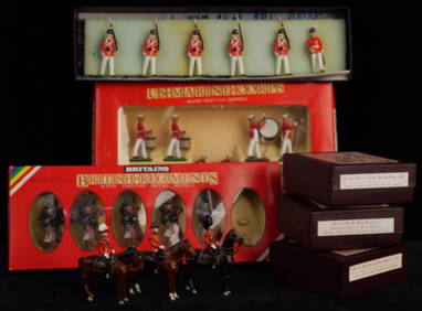
BRITAINS, IMPERIAL and TRADITION TOY SOLDIERSJohn McInnis Auctioneers,LLC4.6(504)See Sold PriceFeb 24, 2024
10 Books including: The Future as History, The Bedside Tales, Whitefish & MoreCain Modern Auctions4.4(44)See Sold PriceFeb 28, 2024
American Patrick Henry Davenport 1803-1890 Portrait Of John Robert Allen Oil On CanvasRbfinearts4.4(575)See Sold PriceFeb 24, 2024
[LITHOGRAPHY]. Group of 41 Trade Cards for American Domesti...Potter & Potter Auctions4.6(544)See Sold PriceMar 07, 2024
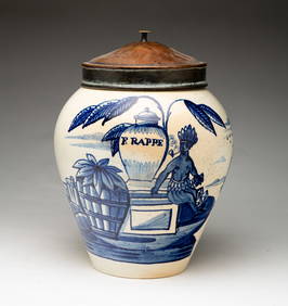
DELFT "THREE BELLS POTTERY" TOBACCO JAR.Amelia Jeffers, Auctioneers & Appraisers4.5(116)See Sold PriceMar 08, 2024
Musicians & Theatrical.- Collection of letters and postcards, 19th – 20th centuries (c. 120).Forum Auctions4.3(53)See Sold PriceFeb 29, 2024
Pair of Antique East India Porcelain Plate & TureenAkiba Galleries4.7(1.8k)See Sold PriceFeb 29, 2024
Churchill & Nieuhof 1744 Folio Print. India - Malabar Man & WomanAlbion Auctions4.6(341)See Sold PriceMar 07, 2024
Churchill & Nieuhof 1744 Folio Print. India - Snake Charmer, MalabarAlbion Auctions4.6(341)See Sold PriceMar 07, 2024
Churchill & Nieuhof 1744 LG Folio Print. India - Pearl Fishery, Toutte CourynAlbion Auctions4.6(341)See Sold PriceMar 07, 2024
Churchill & Nieuhof 1744 LG Folio Print. India - Taking of Cochin, ShipsAlbion Auctions4.6(341)See Sold PriceMar 07, 2024
Churchill & Nieuhof 1744 Print. India - Nieuhof & Queen of Koylang, Bats & Malabar MammalsAlbion Auctions4.6(341)See Sold PriceMar 07, 2024
WWII RARE RAF Eagle Squadron ID'D UniformEagles Corps International LLC4.5(107)See Sold PriceMar 10, 2024
The Blue Max And Thompson Trophy Racers SoftcoversRapid Estate Liquidators and Auction Gallery4.5(1.1k)See Sold PriceFeb 25, 2024


![Chart of the Entrance of Hudson's River. [1776]. (1 of 3)](https://p1.liveauctioneers.com/179/64124/32202587_1_x.jpg?height=282&quality=70&version=1416275428)
![[ENGLAND]. Britanniae Antiquae Tabula Geograp (1 of 1)](https://p1.liveauctioneers.com/179/10971/2682714_1_x.jpg?height=282&quality=70&version=1162265652)


![[LITHOGRAPHY]. Group of 41 Trade Cards for American Domesti... (1 of 1)](https://p1.liveauctioneers.com/928/318880/171361100_1_x.jpg?height=282&quality=70&version=1707501302)


![[BATTLE OF BRITAIN]: (1 of 1)](https://p1.liveauctioneers.com/1458/320148/172030845_1_x.jpg?height=282&quality=70&version=1708367366)

