ATLAS of ANTIENT GEOGRAPHY by SAMUEL BUTLER 1843John McInnis Auctioneers,LLC4.6(502)See Sold PriceFeb 24, 2024
18TH C. ANTIQUE MAP: FRENCH & INDIAN WAR, FRAMEDThomaston Place Auction Galleries4.4(386)See Sold PriceFeb 24, 2024
Rand McNally Railroad Map Cabinet w/ 21 Railroad MapsRail & Road Auctions4.6(165)See Sold PriceMar 08, 2024
Keith Haring - Ink on New York Map, Best Buddies, Inscribed, Signed, and DatedSapphire Auction Gallery4(67)See Sold PriceMar 02, 2024
LATE 17TH C. FRENCH MAP OF THE NEW WORLD BY ALEXIS-HUBERT JAILLOT (1632-1712)Thomaston Place Auction Galleries4.4(386)See Sold PriceFeb 24, 2024
Central Railroad of New Jersey Map of Sandy Hook Route-ca. 1903JM Hobby Supply and Railroad Artifact Auctions4.4(126)See Sold PriceFeb 24, 2024
Lot of Six Mixed Atlas Box Cars-HO Scale-New in BoxJM Hobby Supply and Railroad Artifact Auctions4.4(126)See Sold PriceFeb 25, 2024
Rand McNally/Santa Fe Railroad Map of Iowa-1912JM Hobby Supply and Railroad Artifact Auctions4.4(126)See Sold PriceFeb 24, 2024
NICOLAES VISSCHER (NETHERLANDS, 1618-1709) MAP OF THE NEW WORLDThomaston Place Auction Galleries4.4(386)See Sold PriceFeb 24, 2024
17TH C. WORLD MAP BY NICOLAES VISSCHER (NETHERLANDS, 1618-1709)Thomaston Place Auction Galleries4.4(386)See Sold PriceFeb 24, 2024
Lot of Six Mixed Atlas Cabooses-HO Scale-New in BoxJM Hobby Supply and Railroad Artifact Auctions4.4(126)See Sold PriceFeb 25, 2024
Bellin, J. N. Costes Orientales de L' AmeriqueBellin, Jacques Nicolas Carte Reduite du Costes Orientales de L'Amerique Septentrionale É 1757 Copperplate engraving; uncoloured Printed area: 62.5 x 49.5 cm; 24.6 x 19.5 in Large and detailed chartSee Sold Price
SoldBellin (J N) N.E. coast of USABellin (Jacques Nicolas) Carte Reduite des Costes Orientales de l'Amerique Septentrionale,coastal chart of north east America, from Labrador to New York, with inset plan of Boston harbour, engSee Sold Price
MAP, Northeast US & Canada, BellinColonial Northeast United States & Canada. Jacques Nicolas Bellin, Carte Reduite des Costes Orientales de l'Amerique Septentrionale 1re Feuille Contenant l'Isle Royale, l'Accadie, la Baye Francoise, lSee Sold Price
Bellin (Nicolas) Carte Reduite des Costes Orientales deBellin (Nicolas) Carte Reduite des Costes Orientales de l'Amérique Septentrionale, detailed coastal chart of northeast North America, from Nova Scotia to south of Long Island, with inset plan of BostSee Sold Price
SoldEngraved Map of the East Coast of AmericaJacques-Nicolas Bellin (1703-1772), "Carte Reduite des Costes Orientales de L'Amerique Septentrionale," Paris, 1757. Hand colored engraved map of the northeast coast of North America, showing what isSee Sold Price
Bellin (Jacques Nicolas) Carte Reduite des CostesBellin (Jacques Nicolas) Carte Reduite des Costes Orientales de l'Amerique Septentrionale,from south of Long Island to Isle Royale, with inset map of Boston Harbour lower right, large decoratiSee Sold Price
Americas.- Bellin (Jacques Nicolas) Carte Reduite desAmericas.- Bellin (Jacques Nicolas) Carte Reduite des Costes Orientales de l'Amérique Septentrionale, sea chart of northeast North America, showing from Nova Scotia to south of Long Island, withSee Sold Price
SoldL'Amerique Septentrionale, M. Bellin 1757Title: Carte Reduite Des Costes Orientales de L'Amerique Septentrionale Subject: East coast of North America from The Maritimes in Canada south to New Jersey, inset plan of Boston Harbor Maker: M. BelSee Sold Price
FRAMED 1757 BELLIN MAP OF THE DOWNEAST COASTCarte Reduite des Costes Orientales de L'Amerique Septentrionale, 1re Feuille contenant L'Isle Royale, L'Accadie, La Baye Francoise, La Nouvelle Angleterre, et la Nouvelle Yorc. Pour le Service des VaSee Sold Price
SoldBellin (J N) Carte de L'Ocean MeridionalBellin (Jacques Nicolas) Carte Réduite de L'Ocean Meridional; ...des Costes de la Guyane,South America and the Guianan coast, decorative title cartouches, 2 engraved charts, 545 x 870mm., andSee Sold Price
SoldBellin: Plan De L’Isle a Vache, 1764“Plan De L’Isle a Vache a la Coste du Sud de S. Domingue”, by J.N. Bellin, 1764 from “Le Petit Atlas Maritime…”. Fine, tinting, in matting and tagged to top margin, measures 9 x 12”. PleSee Sold Price
Plan De L’Isle a Vache a la Coste du Sud 1764Map: Plan De L’Isle a Vache a la Coste du Sud de S. Domingue Maker: J.N. Bellin Date: 1764 From "Le Petit Atlas Maritime…" Size: 9 x 12 inches Jacques-Nicolas Bellin(1703-1772) was a French cartogSee Sold Price
Sold1757 FRENCH MAP OF AMERIAN AND CANADIAN ATLANTIC COAST1757 FRENCH MAP OF AMERIAN AND CANADIAN ATLANTIC COAST AND BOSTON Hand-colored printed map: "Carte Reduit des Costes Orientales de l'Amerique Septentrionale, Ire Feuille...", 1757, prepared by "M. BelSee Sold Price
1757 French Map of East CoastColonial Era Map of the East Coast from New York to Canada, Featuring Inset of the Boston Harbor 1757, "CARTE REDUITE DES COSTES ORIENTALES DE L'AMERIQUE SEPTENTRIONALE," & "PLAN DU HAVRE DE BASTON,"See Sold Price
SoldBellin (J N) Carte de l'ocean occidentaleBellin (J.N.) Carte de l'ocean occidentale, Atlantic Ocean showing the east coast of America, the Gulf of Mexico, and the west coasts of Europe and north Africa, decorative title cartouche, enSee Sold Price
SoldBellin (J N) Carte de L'Isle de La BarbadeWest Indies.- Bellin (J N) Carte de L'Isle de La Barbade, engraved map of Barbados, with hand-colouring, large decorative cartouche, 560 x 405mm., occasional very light spotting, tipped-in toSee Sold Price
Bellin (J N) Carte de Saint DomingueBellin (J.N.) Carte de l'Isle de Saint Domingue, 2 engraved chart of Dominique, on two sheets, joined, with outline hand-colouring, 570 x 910mm., colour faded, repair to verso, some surface weSee Sold Price
Bellin (J N) Carte de L'Ocean OccidentalBellin (J.N.) Carte de L'Ocean Occidental, engraved chart of the Atlantic Ocean showing the east coast of America, part of Europe and the north west coast of Africa, ornamental cartouche, withSee Sold Price
SoldBellin (J.N.) Carte de L'Ocean OccidentalBellin (J.N.) Carte de L'Ocean Occidentalengraved chart of the Atlantic Ocean showing the east coast of America, part of Europe and the north west coast of Africa, ornamental cartouche, with hSee Sold Price
Bellin (J.N.) Carte de l'Ocean OccidentalBellin (J.N.) Carte de l'Ocean Occidental, Dressée pour servir a l'Histoire Generale des Voyages,Atlantic chart, central compass rose and rhum lines with the east coast of North America, the nSee Sold Price
SoldBellin (J N) Carte de L'Ocean MeridionalBellin (J.N.) Carte Réduite de L'Ocean Meridional, engraved chart of the South Atlantic Ocean showing part of South America and South Africa, 560 x 880mm., large decorative cartouche, extensivSee Sold Price
SoldBellin (J N) Carte de la Coste de GuinéeBellin (Jacques Nicolas) Carte Generale de la Coste de Guinée,Guinea coastline, extending from the Sierra Leone river to Cape Lopez Gonsalvo in Gabon, ornamental title cartouche, coastal profiSee Sold Price
SoldMap : A hand coloured map by J N Bellin Carte de LMap : A hand coloured map by J N Bellin Carte de La Louisiane Cours Du Mississipi et Pais Voisons issued in Charlevois's Histoire et Dexcriotion Generale de la Nouvelle France 1744, showing various paSee Sold Price
SoldJacques Nicolas Bellin (1703-1772)Jacques Nicolas Bellin (1703-1772), West Indian Maps from the Petit Atlas, v. I [Paris]: J. N. Bellin, 1764. "L'Amerique septentrionale et les Isles Antilles", telliere folio, a fragmentary copy withSee Sold Price
Roman Bronze Looped Figural Pendant with PhallusTimeLine Auctions Ltd.4.5(183)See Sold PriceMar 06, 2024
D. CHIPARIUS (20TH CENTURY) Bronze Dancer Raised on stepped marble base, the figure 21.5cm high toAdam's Auctioneers4.3(5)See Sold PriceFeb 27, 2024
L'Age de Soleil. Picasso, Godet. With one original drypoint, one of 100 copies, 1950.TheRedFinch Auctions4.4(24)See Sold PriceFeb 29, 2024
1764 Bellin Map of Eastern Guadeloupe in the Lesser Antilles -- Partie Orientale de l'Isle de laJasper524.5(9.8k)See Sold PriceFeb 27, 2024
1764 Bellin Map of Mari-Galante Near Guadeloupe -- Carte de l'Isle de Mari-GalanteJasper524.5(9.8k)See Sold PriceFeb 27, 2024
1764 Bellin Map of St. Kitts -- Carte de l'Isle St. ChristopheJasper524.5(9.8k)See Sold PriceFeb 27, 2024
1764 Bellin Map of Western Guadeloupe in the Lesser Antilles -- Partie Occidentale de l'Isle de laJasper524.5(9.8k)See Sold PriceFeb 27, 2024
1764 Bellin Map of Antigua -- Carte de l'Isle d'Antigue Situee par la Latitude 17 Degres et par laJasper524.5(9.8k)See Sold PriceFeb 27, 2024
Coste Orientale d’Afrique…' South Africa. Mozambique channel. BELLIN 1746 mapJasper524.5(9.8k)See Sold PriceFeb 28, 2024
Coste Occidentale d’Afrique…' West Africa. Gulf of Guinea. BELLIN 1746 mapJasper524.5(9.8k)See Sold PriceFeb 28, 2024
WHISTLER JAMES MCNEILL: (1834-1903)International Autograph Auctions Europe S.L.4.5(52)See Sold PriceMar 13, 2024
GAUGUIN PAUL: (1848-1903)International Autograph Auctions Europe S.L.4.5(52)See Sold PriceMar 14, 2024
LUCE MAXIMILIEN: (1858-1941)International Autograph Auctions Europe S.L.4.5(52)See Sold PriceMar 14, 2024
VAN DONGEN KEES: (1877-1968)International Autograph Auctions Europe S.L.4.5(52)See Sold PriceMar 14, 2024
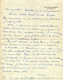
HUGO VICTOR: (1802-1885)International Autograph Auctions Europe S.L.4.5(52)See Sold PriceMar 14, 2024
HUGO VICTOR: (1802-1885)International Autograph Auctions Europe S.L.4.5(52)See Sold PriceMar 14, 2024
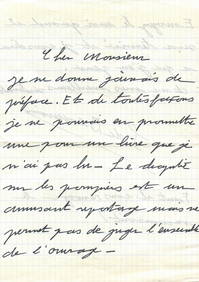
MONTHERLANT HENRY DE: (1895-1972)International Autograph Auctions Europe S.L.4.5(52)See Sold PriceMar 14, 2024
BEAUVOIR SIMONE DE: (1908-1986)International Autograph Auctions Europe S.L.4.5(52)See Sold PriceMar 14, 2024
BERTRAND JOSEPH: (1822-1900)International Autograph Auctions Europe S.L.4.5(52)See Sold PriceMar 14, 2024