ATLAS of ANTIENT GEOGRAPHY by SAMUEL BUTLER 1843John McInnis Auctioneers,LLC4.6(504)See Sold PriceFeb 24, 2024
18TH C. ANTIQUE MAP: FRENCH & INDIAN WAR, FRAMEDThomaston Place Auction Galleries4.4(389)See Sold PriceFeb 24, 2024
Rand McNally Railroad Map Cabinet w/ 21 Railroad MapsRail & Road Auctions4.6(165)See Sold PriceMar 08, 2024
Keith Haring - Ink on New York Map, Best Buddies, Inscribed, Signed, and DatedSapphire Auction Gallery4.1(67)See Sold PriceMar 02, 2024
LATE 17TH C. FRENCH MAP OF THE NEW WORLD BY ALEXIS-HUBERT JAILLOT (1632-1712)Thomaston Place Auction Galleries4.4(389)See Sold PriceFeb 24, 2024
Central Railroad of New Jersey Map of Sandy Hook Route-ca. 1903JM Hobby Supply and Railroad Artifact Auctions4.4(126)See Sold PriceFeb 24, 2024
Lot of Six Mixed Atlas Box Cars-HO Scale-New in BoxJM Hobby Supply and Railroad Artifact Auctions4.4(126)See Sold PriceFeb 25, 2024
Rand McNally/Santa Fe Railroad Map of Iowa-1912JM Hobby Supply and Railroad Artifact Auctions4.4(126)See Sold PriceFeb 24, 2024
NICOLAES VISSCHER (NETHERLANDS, 1618-1709) MAP OF THE NEW WORLDThomaston Place Auction Galleries4.4(389)See Sold PriceFeb 24, 2024
17TH C. WORLD MAP BY NICOLAES VISSCHER (NETHERLANDS, 1618-1709)Thomaston Place Auction Galleries4.4(389)See Sold PriceFeb 24, 2024
Lot of Six Mixed Atlas Cabooses-HO Scale-New in BoxJM Hobby Supply and Railroad Artifact Auctions4.4(126)See Sold PriceFeb 25, 2024
Bartholomew: Map of Sweden & Norway, 1898Map: Sweden & Norway Date: 1898 From Bartholomew's "The Citizen's Atlas of the World" Size: 18 x 14 inches Please note that this lot has a confidential reserve. When you leave a bid in advance of theSee Sold Price
An accurate map of Sweden, Denmark and Norway. BOWEN. Scandinavia 1789 oldTITLE/CONTENT OF MAP: 'Sweden & Norway; Inset maps of Christiania; Stockholm' DATE PRINTED: 1898 IMAGE SIZE: Approx 43.0 x 32.5cm, 16.75 x 12.75 inches (Large); Please note that this is a folding map.See Sold Price
Sweden & Norway. Baltic Sea &C.Title/Content of Map: Sweden & Norway. Baltic Sea &C. Date: 1879 Cartographer: BARTHOLOMEW, J. Size: 19.75Height - 14.75Width Publisher: A. & C. Black Small sketch map showing the relative position anSee Sold Price
YUGOSLAVIA. Trieste international zone. Slovenian Istria. BARTHOLOMEW 1947 mapTITLE/CONTENT OF MAP: 'Sweden and Norway with Russian Finland' DATE PRINTED: 1860 IMAGE SIZE: Approx 53.5 x 43.0cm, 21 x 17 inches (Large); Please note that this is a folding map. TYPE: Antique atlasSee Sold Price
EUROPE. Ethnographic. Racial. BARTHOLOMEW 1952 old vintage map plan chartTITLE/CONTENT OF MAP: 'Sweden and Norway' DATE PRINTED: 1709 IMAGE SIZE: Approx 29.5 x 19.5cm, 11.5 x 7.75 inches (Medium) TYPE: Antique copperplate map CONDITION: Good; suitable for framing. Please cSee Sold Price
1873 Map of Sweden and NorwayAuthor: Bartholomew Title: 1873 Map of Sweden and Norway Medium: Ink on Paper Dimensions: 14"X18.5" Description: Map of Sweden and Norway dated 1873. Edited and by J.G. Bartholomew. Published by GeorgSee Sold Price
1873 Map of Sweden and NorwayAuthor: Bartholomew Title: 1873 Map of Sweden and Norway Medium: Ink on Paper Dimensions: 14"X18.5" Map of Sweden and Norway dated 1873. Edited and by J.G. Bartholomew. Published by George Newnes in LSee Sold Price
1873 Map of Sweden and NorwayTitle: 1873 Map of Sweden and Norway Author: Bartholomew Materials: Ink on Paper Dimensions: 14"X18.5" Description: Map of Sweden and Norway dated 1873. Edited and by J.G. Bartholomew. Published by GeSee Sold Price
1873 Map of Sweden and NorwayAuthor: Bartholomew Title: 1873 Map of Sweden and Norway Medium: Ink on Paper Dimensions: 14"X18.5" Description: Map of Sweden and Norway dated 1873. Edited and by J.G. Bartholomew. Published by GeorgSee Sold Price
1873 Map of Sweden and NorwayAuthor: Bartholomew Title: 1873 Map of Sweden and Norway Materials: Ink on Paper Size/Dimensions: 14"X18.5" Description: Map of Sweden and Norway dated 1873. Edited and by J.G. Bartholomew. PublishedSee Sold Price
1873 Sweden and Norway MapAuthor: Bartholomew Title: 1873 Sweden and Norway Map Medium: Ink on Paper Dimensions: 14"X18.5" Map of Sweden and Norway dated 1873. Edited and by J.G. Bartholomew. Published by George Newnes in LondSee Sold Price
SCANDINAVIA. Norway and Sweden, Central. Railways. BARTHOLOMEW 1944 old mapTITLE/CONTENT OF MAP: 'Norway and Sweden, Central' This map was printed in an atlas that was published during the Second World War. Many of the maps show the advance of the Axis powers including the dSee Sold Price
SCANDINAVIA. Norway and Sweden, Central. Railways. BARTHOLOMEW 1952 old mapTITLE/CONTENT OF MAP: 'Norway and Sweden, Central' DATE PRINTED: 1952 IMAGE SIZE: Approx 34.0 x 44.5cm, 13.25 x 17.5 inches (Large); Please note that this is a folding map. TYPE: Vintage colour map; SSee Sold Price
Sweden, Norway & the Baltic Sea. Scandinavia. BARTHOLOMEW 1862 old antique mapTITLE OF PRINT (NOT PRINTED ON THE PAGE):'Sweden & Norway, Baltic Sea &c.' DATE PRINTED: 1862 IMAGE SIZE: Approx 54.0 x 42.0cm, 21.25 x 16.5 inches (Large); Please note that this is a folding map. TYPSee Sold Price
Sweden & Norway. Scandinavia. Railways. BARTHOLOMEW 1870 old antique map chartTITLE OF MAP (NOT PRINTED ON THE PAGE):'Sweden & Norway, Baltic Sea &c.' DATE PRINTED: 1870 IMAGE SIZE: Approx 54.5 x 40.5cm, 21.25 x 16 inches (Large); Please note that this is a folding map. TYPE: ASee Sold Price
Sweden & Norway. Scandinavia. Railways. BARTHOLOMEW 1870 old antique map chartTITLE/CONTENT OF MAP: 'Transport Map of Central Europe' DATE PRINTED: 1927 IMAGE SIZE: Approx 49.5 x 72.0cm, 19.5 x 28.25 inches (Large); Please note that this is a folding map. TYPE: Antique colour mSee Sold Price
Danemarc #8 Denmark. Southern Sweden & Norway. VANDERMAELEN 1827 old mapTITLE OF MAP (NOT PRINTED ON THE PAGE):'Europe' DATE PRINTED: 1898 IMAGE SIZE: Approx 44.5 x 57.0cm, 17.5 x 22.5 inches (Large); Please note that this is a folding map. TYPE: Antique atlas map CONDITISee Sold Price
Sweden & Norway. Baltic Sea &C.Title: Sweden & Norway. Baltic Sea &C. Cartographer: BARTHOLOMEW, J. Publisher: A. & C. Black Height: 19.75 Width: 14.75 Small sketch map showing the relative position and climate of Norway. Some topoSee Sold Price
SoldGuthrie, William 1799 Map Sweden Norway Finland DenmarkOutline Hand Colored Copper Engraved Map Published 1799, London for "A New Geographical, Historical and Commercial Grammar..." by William Guthrie. The maps are by D. Ogilby & Son and others. Folds asSee Sold Price
SDUK: Antique Map of Scandinavia, 1845Title/Content of Map: 'SWEDEN, NORWAY, AND DENMARK'. Scandinavia. Population table. Date Printed: The map was originally published in 1841. This date is printed on the map. This edition of the map wasSee Sold Price
Sweden, Norway & DenmarkTitle/Content of Map: Sweden, Norway & Denmark Date: 1841 Cartographer: WALKER, J. & C. Publisher: SOCIETY FOR THE DIFFUSION OF USEFUL KNOWLEDGE/S.D.U.K. Size: 15.5Height - 12.1Width Details topographSee Sold Price
SCANDINAVIA. Sweden, Norway, and Denmark. PopulationTITLE/CONTENT OF MAP: 'SWEDEN, NORWAY, AND DENMARK' Date: The map was originally published in 1841. This date is printed on the map. This edition of the map was published in 1845 IMAGE SIZE: Approx 41See Sold Price
SoldSCANDINAVIA. Sweden, Norway, and Denmark. Populations. SDUK 1857 old mapTITLE/CONTENT OF MAP: 'SWEDEN, NORWAY, AND DENMARK' DATE PRINTED: 1857 IMAGE SIZE: Approx 41.0 x 33.5cm, 16.25 x 13.25 inches (Large) TYPE: Antique steel engraved map with original hand colouring CONDSee Sold Price
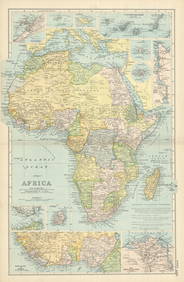
Scandinavia political divisions. Sweden Lans. Norway Amts. STANFORD 1887 mapTITLE/CONTENT OF MAP: 'Sweden & Norway' DATE PRINTED: 1887 IMAGE SIZE: Approx 66.0 x 54.0cm, 26 x 21.25 inches (Large); Please note that this is a folding map. TYPE: Large (folio) antique atlas map COSee Sold Price
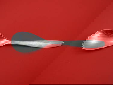
Swedish Modern by Allan Adler Sterling Silver Grapefruit Spoon Original 6"Bidhaus4.3(757)See Sold PriceFeb 25, 2024
1558 SCANDINAVIA SWEDEN ILLUSTRATED HISTORY Gothorum Sveonumque historia antiqueJasper524.5(9.8k)See Sold PriceFeb 27, 2024
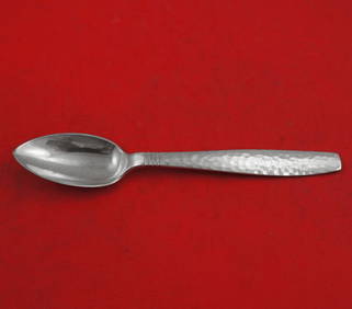
Swedish Modern by Allan Adler Sterling Silver Preserve Spoon 7"Mynt Auctions4.6(689)See Sold PriceMar 01, 2024
AFRICA. French West Africa. Rio de Oro Rio Muni Nigeria. BARTHOLOMEW 1952 mapJasper524.5(9.8k)See Sold PriceFeb 28, 2024
NORTH & COLONIAL WEST AFRICA. Nigeria marked as "Royal Niger Company" 1898 mapJasper524.5(9.8k)See Sold PriceFeb 28, 2024
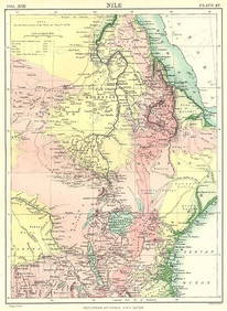
NILE VALLEY. Sudan Tanzania Ethiopia Uganda Lake Victoria. Britannica. 1898 mapJasper524.5(9.8k)See Sold PriceFeb 28, 2024
Algeria Morocco & Tunis. North Africa. Tunisia. Maghreb. BARTHOLOMEW 1898 mapJasper524.5(9.8k)See Sold PriceFeb 28, 2024
COLONIAL CENTRAL AFRICA. Congo German East Africa Rhodesia. BARTHOLOMEW 1898 mapJasper524.5(9.8k)See Sold PriceFeb 28, 2024
Central Africa. Congo Zambia Tanzania Kenya Mozambique. BARTHOLOMEW 1886 mapJasper524.5(9.8k)See Sold PriceFeb 28, 2024
NORTH AFRICA. Morocco Algeria Tunis Tunisia Egypt. Cairo. BARTHOLOMEW 1912 mapJasper524.5(9.8k)See Sold PriceFeb 28, 2024
NORTH AFRICA. Morocco Algeria Tunis Tunisia Egypt. Cairo. BARTHOLOMEW 1901 mapJasper524.5(9.8k)See Sold PriceFeb 28, 2024
AFRICA French Congo State Soudan Nile Delta Suez canal by GW BACON 1898 mapJasper524.5(9.8k)See Sold PriceFeb 28, 2024
Cooke, George 1801 Antique Map. Sweden, Denmark, Norway, IcelandAlbion Auctions4.6(341)See Sold PriceMar 01, 2024
BERNADOTTE JEAN BAPTISTE: (1763-1844)International Autograph Auctions Europe S.L.4.5(52)See Sold PriceMar 14, 2024
Carl J. Sundevall (1801 - 1875) Set of 4 Bird Prints - Dove - Woodpecker - DuckProverde Auctions4.3(3)See Sold PriceFeb 28, 2024
Set of 4 Maps - Netherlands - Seven United Provinces - Germany - Sweden, Denmark, Norway, FinlandProverde Auctions4.3(3)See Sold PriceFeb 28, 2024