ATLAS of ANTIENT GEOGRAPHY by SAMUEL BUTLER 1843John McInnis Auctioneers,LLC4.6(502)See Sold PriceFeb 24, 2024
18TH C. ANTIQUE MAP: FRENCH & INDIAN WAR, FRAMEDThomaston Place Auction Galleries4.4(386)See Sold PriceFeb 24, 2024
Rand McNally Railroad Map Cabinet w/ 21 Railroad MapsRail & Road Auctions4.6(165)See Sold PriceMar 08, 2024
Keith Haring - Ink on New York Map, Best Buddies, Inscribed, Signed, and DatedSapphire Auction Gallery4(67)See Sold PriceMar 02, 2024
LATE 17TH C. FRENCH MAP OF THE NEW WORLD BY ALEXIS-HUBERT JAILLOT (1632-1712)Thomaston Place Auction Galleries4.4(386)See Sold PriceFeb 24, 2024
Central Railroad of New Jersey Map of Sandy Hook Route-ca. 1903JM Hobby Supply and Railroad Artifact Auctions4.4(126)See Sold PriceFeb 24, 2024
Lot of Six Mixed Atlas Box Cars-HO Scale-New in BoxJM Hobby Supply and Railroad Artifact Auctions4.4(126)See Sold PriceFeb 25, 2024
Rand McNally/Santa Fe Railroad Map of Iowa-1912JM Hobby Supply and Railroad Artifact Auctions4.4(126)See Sold PriceFeb 24, 2024
NICOLAES VISSCHER (NETHERLANDS, 1618-1709) MAP OF THE NEW WORLDThomaston Place Auction Galleries4.4(386)See Sold PriceFeb 24, 2024
17TH C. WORLD MAP BY NICOLAES VISSCHER (NETHERLANDS, 1618-1709)Thomaston Place Auction Galleries4.4(386)See Sold PriceFeb 24, 2024
Lot of Six Mixed Atlas Cabooses-HO Scale-New in BoxJM Hobby Supply and Railroad Artifact Auctions4.4(126)See Sold PriceFeb 25, 2024
Sweden & Norway. Scandinavia. Railways. BARTHOLOMEW 1870 old antique map chartTITLE OF MAP (NOT PRINTED ON THE PAGE):'Sweden & Norway, Baltic Sea &c.' DATE PRINTED: 1870 IMAGE SIZE: Approx 54.5 x 40.5cm, 21.25 x 16 inches (Large); Please note that this is a folding map. TYPE: ASee Sold Price
Sweden & Norway. Scandinavia. Railways. BARTHOLOMEW 1870 old antique map chartTITLE/CONTENT OF MAP: 'Transport Map of Central Europe' DATE PRINTED: 1927 IMAGE SIZE: Approx 49.5 x 72.0cm, 19.5 x 28.25 inches (Large); Please note that this is a folding map. TYPE: Antique colour mSee Sold Price
Sweden and Norway. Scandinavia. Railways. HUGHES 1876 old antique map chartTITLE/CONTENT OF MAP: 'Environs of London; Environs of Paris; Berlin; Rome; Environs of Vienna; St. Petersburg; Constantinople; Copenhagen' DATE PRINTED: 1890 IMAGE SIZE: Approx 30.0 x 41.0cm, 11.75 xSee Sold Price
Sweden, Norway & the Baltic Sea. Scandinavia. BARTHOLOMEW 1862 old antique mapTITLE OF PRINT (NOT PRINTED ON THE PAGE):'Sweden & Norway, Baltic Sea &c.' DATE PRINTED: 1862 IMAGE SIZE: Approx 54.0 x 42.0cm, 21.25 x 16.5 inches (Large); Please note that this is a folding map. TYPSee Sold Price
Sweden and Norway by John Dower. Scandinavia 1845 old antique map plan chartTITLE/CONTENT OF MAP: 'Sweden and Norway' DATE PRINTED: 1845 IMAGE SIZE: Approx 27.5 x 21.5cm, 10.75 x 8.5 inches (Medium) TYPE: Antique map with original hand colouring CONDITION: Good; suitable forSee Sold Price
Sweden and Norway by John Dower. Scandinavia 1845 old antique map plan chartTITLE/CONTENT OF MAP: 'Sweden and Norway' DATE PRINTED: 1845 IMAGE SIZE: Approx 27.5 x 21.5cm, 10.75 x 8.5 inches (Medium) TYPE: Antique map with original hand colouring CONDITION: Good; suitable forSee Sold Price
SCANDINAVIA. Norway and Sweden, Central. Railways. BARTHOLOMEW 1944 old mapTITLE/CONTENT OF MAP: 'Norway and Sweden, Central' This map was printed in an atlas that was published during the Second World War. Many of the maps show the advance of the Axis powers including the dSee Sold Price
SCANDINAVIA. Norway and Sweden, Central. Railways. BARTHOLOMEW 1952 old mapTITLE/CONTENT OF MAP: 'Norway and Sweden, Central' DATE PRINTED: 1952 IMAGE SIZE: Approx 34.0 x 44.5cm, 13.25 x 17.5 inches (Large); Please note that this is a folding map. TYPE: Vintage colour map; SSee Sold Price
EUROPE. Ethnographic. Racial. BARTHOLOMEW 1952 old vintage map plan chartTITLE/CONTENT OF MAP: 'Sweden and Norway' DATE PRINTED: 1709 IMAGE SIZE: Approx 29.5 x 19.5cm, 11.5 x 7.75 inches (Medium) TYPE: Antique copperplate map CONDITION: Good; suitable for framing. Please cSee Sold Price
Carte de L'Europe. Map of Europe. MALTE-BRUN c1871 old antique plan chartTITLE/CONTENT OF MAP: 'Scandinavia, or Sweden, Denmark and Norway' DATE PRINTED: 1830 IMAGE SIZE: Approx 60.5 x 51.0cm, 23.75 x 20 inches (Large); Please note that this is a folding map. TYPE: AntiqueSee Sold Price
Holland, Belgium & Luxembourg. Benelux. BARTHOLOMEW 1870 old antique map chartTITLE/CONTENT OF MAP: 'ANCIENT MACEDONIA, THRACIA, ILLYRIA, MOESIA AND DACIA' DATE PRINTED: This map was originally published by Baldwin & Cradock in 1830; this date is printed on the map. This editioSee Sold Price
Sweden and Norway by Herman Moll. Scandinavia Finland 1709 old antique mapTITLE/CONTENT OF MAP: 'Sweden and Norway' DATE PRINTED: 1709 IMAGE SIZE: Approx 29.5 x 19.5cm, 11.5 x 7.75 inches (Medium) TYPE: Antique copperplate map CONDITION: Good; suitable for framing. Please cSee Sold Price
Sweden and Norway by Herman Moll. Scandinavia Finland 1709 old antique mapTITLE/CONTENT OF MAP: 'Europe' DATE PRINTED: 1856 IMAGE SIZE: Approx 28.0 x 40.5cm, 11 x 15.75 inches (Large) TYPE: Antique atlas map with original hand colouring / coloring CONDITION: Good; suitableSee Sold Price
Colton's Sweden and Norway. Decorative antique map. Scandinavia 1869 oldTITLE OF MAP (NOT PRINTED ON THE PAGE):'Colton's Sweden and Norway' DATE PRINTED: 1869 IMAGE SIZE: Approx 42.0 x 33.5cm, 16.5 x 13.25 inches (Large) TYPE: Antique engraved hand coloured atlas map CONDSee Sold Price
Colton's Sweden and Norway. Decorative antique map. Scandinavia 1869 oldTITLE/CONTENT OF MAP: 'The War in Eastern Europe - Final Russian Campaign in Central Europe - Operations, 16 April-7 May 1945' DATE PRINTED: 1959 IMAGE SIZE: Approx 25.0 x 33.5cm, 9.75 x 13 inches (LaSee Sold Price
SCANDINAVIA Northern Sweden & Norway, Finland, Karelia & Murmansk. SDUK 1874 mapTITLE/CONTENT OF MAP: 'Eastern European Ports and Waterways' DATE PRINTED: 1918 IMAGE SIZE: Approx 49.0 x 34.0cm, 19.25 x 13.5 inches (Large) TYPE: Antique colour maritime map chart; Scale 1:20,000,00See Sold Price
Sweden & Norway. Scandinavia showing provinces. SIDNEY HALL 1856 old mapCAPTION PRINTED BELOW PICTURE: 'Sweden & Norway' DATE PRINTED: 1856 IMAGE SIZE: Approx 40.5 x 28.5cm, 16 x 11.25 inches (Large) TYPE: Antique atlas map with original hand colouring / coloring CONDITIOSee Sold Price
Suède et Norvège. Sweden and Norway. Scandinavia. MALTE-BRUN c1871 old mapTITLE/CONTENT OF MAP: 'Suède et Norvège [Sweden and Norway]' DATE PRINTED: c1871 IMAGE SIZE: Approx 33.0 x 24.5cm, 13 x 9.5 inches (Large) TYPE: Antique 19th century engraved atlas map withSee Sold Price
Suède et Norvège. Sweden and Norway. Scandinavia. MALTE-BRUN c1871 old mapTITLE/CONTENT OF MAP: 'Suède et Norvège [Sweden and Norway]' DATE PRINTED: c1871 IMAGE SIZE: Approx 33.0 x 24.5cm, 13 x 9.5 inches (Large) TYPE: Antique 19th century engraved atlas map withSee Sold Price
Sweden and Norway with Russian Finland. Scandinavia. SWANSTON 1860 old mapTITLE/CONTENT OF MAP: 'Sweden and Norway with Russian Finland' DATE PRINTED: 1860 IMAGE SIZE: Approx 53.5 x 43.0cm, 21 x 17 inches (Large); Please note that this is a folding map. TYPE: Antique atlasSee Sold Price
Sweden and Norway by Arrowsmith & Lewis. Scandinavia & Finland 1812 old mapTITLE/CONTENT OF MAP: 'Sweden and Norway' DATE PRINTED: 1812 IMAGE SIZE: Approx 25.0 x 20.0cm, 9.75 x 8 inches (Medium) TYPE: Antique steel engraved map CONDITION: Good; suitable for framing. Please cSee Sold Price
SoldSCANDINAVIA. Sweden, Norway, and Denmark. Populations. SDUK 1857 old mapTITLE/CONTENT OF MAP: 'SWEDEN, NORWAY, AND DENMARK' DATE PRINTED: 1857 IMAGE SIZE: Approx 41.0 x 33.5cm, 16.25 x 13.25 inches (Large) TYPE: Antique steel engraved map with original hand colouring CONDSee Sold Price
Scandinavia including Sweden, Norway & Denmark. Iceland. LIZARS 1842 old mapTITLE/CONTENT OF MAP: 'Europe in 1360' DATE PRINTED: 1902 IMAGE SIZE: Approx 25.0 x 33.5cm, 10 x 13.25 inches (Large) TYPE: Antique colour map. This map was published in 1902 but it may depict an earlSee Sold Price
The World on Mercators Projection'. BARTHOLOMEW 1876 old antique map chartCAPTION PRINTED BELOW PICTURE: 'The World on Mercators Projection' DATE PRINTED: 1876 IMAGE SIZE: Approx 23.5 x 31.0cm, 9.25 x 12.25 inches (Large); Please note that this is a folding map. TYPE: AntiqSee Sold Price
Karl Holleck Wethmann (German,Swedish,1872-1955) oil paintingBroward Auction Gallery4.8(277)See Sold PriceMar 10, 2024
Blanche Macarthur (UK,1870-1903) oil painting antiqueBroward Auction Gallery4.8(277)See Sold PriceMar 17, 2024
Carl Folke Sahlin (FL,Sweden,1884-1972) watercolor paintingBroward Auction Gallery4.8(277)See Sold PriceMar 31, 2024
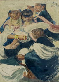
Anne Angelshaug (Norway,b 1977) acrylic paintingBroward Auction Gallery4.8(277)See Sold PriceApr 14, 2024
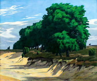
James Baker Pyne (UK,1800-1870) oil painting antiqueBroward Auction Gallery4.8(277)See Sold PriceApr 14, 2024
Mckenney & Hall - Two Octavo Volumes of Text with Rare Plate of Billy BowlegsTrillium Antique Prints & Rare Books4.5(30)See Sold PriceFeb 24, 2024
1738 BIBLE in DUTCH ILLUSTRATED w/ MAPS MASSIVE FOLIO in DUTCH antique BIBLIAJasper524.5(9.8k)See Sold PriceFeb 27, 2024
AFRICA. Pre 'Scramble for Africa'. BARTHOLOMEW 1876 old antique map plan chartJasper524.5(9.8k)See Sold PriceFeb 28, 2024
Alice Best (CA,1870-1926) oil painting antiqueBroward Auction Gallery4.8(277)See Sold PriceMay 19, 2024
George Glenn Newell (NY,MI,CT,1870-1947) oil painting antiqueBroward Auction Gallery4.8(277)See Sold PriceMay 19, 2024