SoldAttributed to Jacques Tanesse, 1834 MapAttributed to Jacques Tanesse, "Plan of the City and Suburbs of New Orleans From Actual Surveys 1834", [no place], 1834, lithographed map, scarce map showing the fauburgs L'Anunciati, De La Course, SoSee Sold Price
SoldJacques Tanesse Map of New Orleans, 1817Jacques Tanesse (New Orleans), "Plan of the City and Suburbs of New Orleans from an Actual Survey made in 1815 by J. Tanesse, City Surveyor", 1817, engraving, drawn by Jacques Tanesse, engraved by WilSee Sold Price
Attributed Jacques L.David1748-1825 Figural StudyAttributed Jacques L. David 1748-1825. Figural Study Priest. pen/ink/grey wash. 9.24x7. Jacques Louis David was a French painter in the neoclassical style. Father of the Whole Modern School. Best knowSee Sold Price
Sold1834 Map of the route passed over by an expedition intoThis highly detailed map depicts the territory of the region between the Red River and Lake Superior within present day Minnesota. The map is centered on the course of the Missisippi River above LakeSee Sold Price
Soldd'Urville, Dumont 1834 Map of the World"Carte General du Voyage Pittoresque autour du Monde" Steel Engraved Map Published 1834 by Chez Furne et Ce, Paris for "Voyage pittoresque autour du Monde - Résumé général des voyages de découverSee Sold Price
Sold1834 Map of EgyptAuthor: Black Title: 1834 Map of Egypt Medium: Ink on Paper Dimensions: 12"X17" Map of Egypt dated 1834. Published by A.C. Black in Edinburgh. Nice map with elaborate borders. Lower left inset of theSee Sold Price
SoldENGRAVING ATTRIBUTED JACQUES BLONDEAU MEDICIENGRAVING ATTRIBUTED JACQUES BLONDEAU MEDICI "Medici coat of arms carried by putti in heaven", 18th century engraving attributed to Jacques Blondeau. Set in silver and gold frame under glass. ShippingSee Sold Price
Scarce (1834) map of New Jersey from Mitchell 1848 atlasHighly detailed and scarce 1834 map of New Jersey, re-published by S. Augustus Mitchell in his 1848 New Universal Atlas. The map shows original hand coloring by county, with great detailing of bays, iSee Sold Price
Sold1834 Map of Kennebec River"The Kennebec River and Adjacent Country Shewing the Routes Examined for a Road from Augusta to the Canada Line in the Direction of Quebec". Reconnoissance made in 1834 by Hartman Bache T.E. & BT. MajSee Sold Price
Attributed JACQUES ANTOINE VALLIN (French 1760-183Attributed JACQUES ANTOINE VALLIN (French 1760-1831) A PAINTING, "A Nymph and Satyr," oil on panel. Note: Attribution certified in Paris January 5, 1975 by Jacques Poinsier, Restaurateur, des Palais NSee Sold Price
Sold1834 Map Village of Auburn NY. Published by Hagama1834 Map Village of Auburn NY. Published by Hagaman & Markham 1834. minor staining and old tape repair. In wooden frame under glass. Note "Profile of Grand Erie Canal" 18 1/2"h x 28 1/2"wSee Sold Price
1834 Map of ScotlandAuthor: Walker Title: 1834 Map of Scotland Medium: Ink on paper Dimensions: 14.5"X18" Map of Scotland dated 1834. Engraved by J.C. Walker. Published in Edinburgh. Key located lower left. Hand coloredSee Sold Price
1834 Map of North AmericaAuthor: Walker Title: 1834 Map of North America Medium: Ink on Paper Dimensions: 13.5"X16" Map of North America dated 1834. Engraved by J.C. Walker and published by Baldwin and Cradock in London. MapSee Sold Price
1834 Map of the ShetlandsAuthor: Walker Title: 1834 Map of the Shetlands Materials: Ink on Paper Dimensions: 14"X16" Description: Map of the Shetlands and Hebrides islands dated 1834. Engraved by J.L. Walker. Published by ChaSee Sold Price
1834 Map of North AmericaAuthor: Walker Title: 1834 Map of North America Medium: Ink on Paper Dimensions: 13.5"X16" Map of North America dated 1834. Engraved by J.C. Walker and published by Baldwin and Cradock in London. MapSee Sold Price
1834 Map of EgyptAuthor: Black Title: 1834 Map of Egypt Medium: Ink on Paper Dimensions: 12"X17" Map of Egypt dated 1834. Published by A.C. Black in Edinburgh. Nice map with elaborate borders. Lower left inset of theSee Sold Price
1834 Map of Colombia and PeruAuthor: Black Title: 1834 Map of Colombia and Peru Medium: Ink on paper Dimensions: 12"X17" Map of Colombia and Peru dated 1834. Engraved by Bloomsbury. Published by A.C. Black in Edinburgh and LondonSee Sold Price
SoldJacques Tanesse (New Orleans)Jacques Tanesse (New Orleans), "Plan of the City and Suburbs of New Orleans from an Actual Survey made in 1815 by J. Tanesse, City Surveyor", 1825, engraving, drawn by Jacques Tanesse, engraved by WilSee Sold Price
1834 Map of the Shetland IslandsTitle: 1834 Map of the Shetland Islands Author: Walker Medium: Ink on Paper Dimension: 14"X16" Description: Map of the Shetlands and Hebrides islands dated 1834. Engraved by J.L. Walker. Published bySee Sold Price
1834 Map of the Scottish Shetland IslandsTitle: 1834 Map of the Scottish Shetland Islands Author: Walker Medium: Ink on Paper Dimensions: 14"X16" Description: Map of the Shetlands and Hebrides islands dated 1834. Engraved by J.L. Walker. PubSee Sold Price
1834 Map of North AmericaAuthor: Walker Title: 1834 Map of North America Medium: Ink on Paper Dimensions: 13.5"X16" Map of North America dated 1834. Engraved by J.C. Walker and published by Baldwin and Cradock in London. MapSee Sold Price
1834 Map of Africa, with LiberiaH.S. Tanner, New Universal Atlas of Empires, Kingdoms, States and RepublicsSee Sold Price
1834 Map of ScotlandAuthor: Grigny Title: 1834 Map of Scotland Medium: Ink on Paper Dimensions: 13"X16" Map of Scotland dated 1832. Drawn by Th.Lejeune. Engraved by Grigny. Published in Brussels. Inset of Shetland Isles.See Sold Price
Tombleson, William 1834 Map of the River Rhine"Tombleson's Upper Rhine" Showing Germany and Switzerland. Steel Engraved Map Published 1832-34, London for "Tombleson's Upper Rhine" Edited by William Gray Fearnside. Illustrated by William TomblesonSee Sold Price
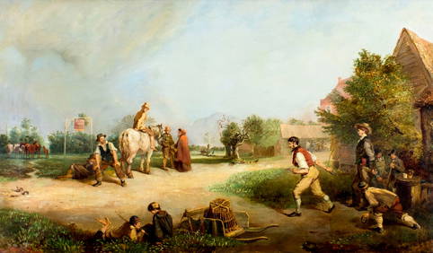
ATTR Philipp Loutherbourg (UK,Germany,1740-1812) oil painting antiqueBroward Auction Gallery4.7(300)See Sold PriceMar 31, 2024
Leather desk lamp, date calendar, attributed to Jacques ADNET.GOLDFIELD AUCTION4.3(32)See Sold PriceMar 02, 2024
1758 MAP PARTIE DE LA MER GLACIALE contenants La Nouvelle Zemble RUSSIA antiqueJasper524.5(9.9k)See Sold PriceFeb 27, 2024
1749 MAP CARTE DE LA TARTARIE ORIENTALE RUSSIA & CHINA antique EASTERN TARTARYJasper524.5(9.9k)See Sold PriceFeb 27, 2024
1834 Malte-Brun Map of the Caribbean -- West India IslandsJasper524.5(9.9k)See Sold PriceFeb 27, 2024
Attributed to Jacques Francois Joseph Swebach-DesfontaineBrunk Auctions4.6(475)See Sold PriceMar 07, 2024
Barthelemy, Jean 1790 Map. Greece - Essa sur la Bataille de PlateeAlbion Auctions4.7(341)See Sold PriceMar 01, 2024
Barthelemy, Jean 1790 Map. Greece - Plan de L'AcademieAlbion Auctions4.7(341)See Sold PriceMar 01, 2024
Barthelemy, Jean 1790 Map. Greece - Essai sur les Environs de DelphesAlbion Auctions4.7(341)See Sold PriceMar 01, 2024
Jacques Nicolas Bellin - Antique Map - Vue de la Rade de Tiniam, double antique coast view of theProverde Auctions4.3(3)See Sold PriceFeb 28, 2024
Attributed : Edgar Degas (1834-1917) Edgar Degas (Pastel on Paper) Signed lower left. BallerinaJoshua Kodner4.2(395)See Sold PriceMar 09, 2024
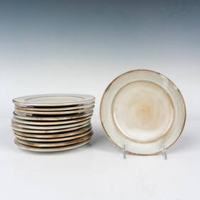
12pc Jacques Pouchain (Attributed) Glazed Small Stoneware PlatesLion and Unicorn4.7(1.9k)See Sold PriceMar 10, 2024
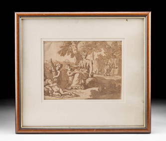
17th C. Ink Wash Drawing Ceres & Putti, ex-Christie'sArtemis Fine Arts4.8(1.4k)See Sold PriceMar 01, 2024
64.99 ctw London Topaz & Diamond Necklace 14K Rose GoldPacific Global Auction3.9(286)See Sold PriceJul 27, 2024