ATLAS of ANTIENT GEOGRAPHY by SAMUEL BUTLER 1843John McInnis Auctioneers,LLC4.6(502)See Sold PriceFeb 24, 2024
18TH C. ANTIQUE MAP: FRENCH & INDIAN WAR, FRAMEDThomaston Place Auction Galleries4.4(386)See Sold PriceFeb 24, 2024
Rand McNally Railroad Map Cabinet w/ 21 Railroad MapsRail & Road Auctions4.6(165)See Sold PriceMar 08, 2024
Keith Haring - Ink on New York Map, Best Buddies, Inscribed, Signed, and DatedSapphire Auction Gallery4(67)See Sold PriceMar 02, 2024
LATE 17TH C. FRENCH MAP OF THE NEW WORLD BY ALEXIS-HUBERT JAILLOT (1632-1712)Thomaston Place Auction Galleries4.4(386)See Sold PriceFeb 24, 2024
Central Railroad of New Jersey Map of Sandy Hook Route-ca. 1903JM Hobby Supply and Railroad Artifact Auctions4.4(126)See Sold PriceFeb 24, 2024
Lot of Six Mixed Atlas Box Cars-HO Scale-New in BoxJM Hobby Supply and Railroad Artifact Auctions4.4(126)See Sold PriceFeb 25, 2024
Rand McNally/Santa Fe Railroad Map of Iowa-1912JM Hobby Supply and Railroad Artifact Auctions4.4(126)See Sold PriceFeb 24, 2024
NICOLAES VISSCHER (NETHERLANDS, 1618-1709) MAP OF THE NEW WORLDThomaston Place Auction Galleries4.4(386)See Sold PriceFeb 24, 2024
17TH C. WORLD MAP BY NICOLAES VISSCHER (NETHERLANDS, 1618-1709)Thomaston Place Auction Galleries4.4(386)See Sold PriceFeb 24, 2024
Lot of Six Mixed Atlas Cabooses-HO Scale-New in BoxJM Hobby Supply and Railroad Artifact Auctions4.4(126)See Sold PriceFeb 25, 2024
1834 Map of Africa, with LiberiaH.S. Tanner, New Universal Atlas of Empires, Kingdoms, States and RepublicsSee Sold Price
SoldHAND COLORED MAP AFRICA BY H S TANNER DATED 1834Framed hand colored map of Africa dated 1834 with map inset of Liberia. Entered according to act of Congress in the year 1834 by H. S., Tanner in the Clerks Office of The Eastern District of PennsylvaSee Sold Price
SoldAFRICA and ABOLITIONISM.Four 19th-century books and a 1940 map of African, as follows: Thatcher, B.B. Memoir of Rev. S. Osgood Wright, late Missionary to Liberia (Boston: Light and Horton, 1834), 12mo, 126 pp., back endpaperSee Sold Price
Map of Africa (Liberia, the Nile & Cape Colony), 1868Original engraving from Johnson's Atlas of the World, 1868. Map includes vignettes of Liberia, the Nile, Cape Colony, Cape Verde Islans & St. Helena and details cities, towns and territories. DimensioSee Sold Price
Map of Africa (Liberia, the Nile & Cape Colony), 1868Original engraving from Johnson's Atlas of the World, 1868. Map includes vignettes of Liberia, the Nile, Cape Colony, Cape Verde Islans & St. Helena and details cities, towns and territories. DimensioSee Sold Price
Map of Africa (Liberia, the Nile & Cape Colony), 1868Original engraving from Johnson's Atlas of the World, 1868. Map includes vignettes of Liberia, the Nile, Cape Colony, Cape Verde Islans & St. Helena and details cities, towns and territories. DimensioSee Sold Price
Map of Africa (Liberia, the Nile & Cape Colony), 1868Original engraving from Johnson's Atlas of the World, 1868. Map includes vignettes of Liberia, the Nile, Cape Colony, Cape Verde Islans & St. Helena and details cities, towns and territories. DimensioSee Sold Price
Map of Africa (Liberia, the Nile & Cape Colony), 1868Original engraving from Johnson's Atlas of the World, 1868. Map includes vignettes of Liberia, the Nile, Cape Colony, Cape Verde Islans & St. Helena and details cities, towns and territories. DimensioSee Sold Price
Map of Africa (Liberia, the Nile & Cape Colony), 1868Original engraving from Johnson's Atlas of the World, 1868. Map includes vignettes of Liberia, the Nile, Cape Colony, Cape Verde Islans & St. Helena and details cities, towns and territories. DimensioSee Sold Price
Sold1834 SDUK Map of South Africa -- South Africa CompiledTitle/Content of Map: 1834 SDUK Map of South Africa -- South Africa Compiled from the M.S. Maps in the Colonial Office Captn. Owen's Survey &c Date: 1834, London Cartographer: SDUK Size: 12.3 x 15.5 iSee Sold Price
1834 SDUK Map of South Africa -- South Africa CompiledTitle/Content of Map: 1834 SDUK Map of South Africa -- South Africa Compiled from the M.S. Maps in the Colonial Office Captn. Owen's Survey &c Date Printed: 1834, London Cartographer: SDUK Size: 12.3See Sold Price
1834 SDUK Map of South Africa -- South Africa CompiledReserve Reduced! Title/Content of Map: 1834 SDUK Map of South Africa -- South Africa Compiled from the M.S. Maps in the Colonial Office Captn. Owen's Survey &c Date: 1834, London Cartographer: SDUK SiSee Sold Price
1834 SDUK Map od South Africa -- South Africa CompiledTitle/Content of Map: 1834 SDUK Map od South Africa -- South Africa Compiled from the M.S. Maps in the Colonial Office Captn. Owen's Survey &c Date: 1834, London Cartographer: SDUK Size: 12.3 x 15.5 iSee Sold Price
SoldS. Walker: Map of Africa, 1834Map: Africa Cartographer: M. Malte-Brun / S. Walker Date: 1834 Origin: Boston Size: 9.3 x 7.5 inches An attractive and highly detailed map with topographical and settlement details. From the AmericanSee Sold Price
1849 Map of Northern Africa,Liberia1849 Map, "AFRICA - NORTH WESTERN SHEET" with Liberia inset, Choice Extremely Fine. 17" x 13.75." Published by J. H. Colton & Co. of New York. Liberia was established by the American Colonization SociSee Sold Price
SoldSDUK: Map of South Africa, 1834Map: South Africa Cartographer: Baldwin & Cradock, Society for the Diffusion of Useful Knowledge Place & Date: London / 1834 Size: 15 1/2" x 12 1/4" The highly detailed South Africa map from the SDUKSee Sold Price
SoldAfrica by H. S. TannerTitle/Content of Map: Africa by H. S. Tanner Date Printed: 1847 Cartographer: TANNER, HENRY SCHENK Size: 12.25x15 Excellent pastel coloring. Inset shows Liberia. Margins browned. Please note that thisSee Sold Price
Cowperthwait: Map of Africa, 1850Map of Africa. Original engraving by Thomas Cowperthwait, circa 1850. Inset features Liberia. Beautiful original color. Dimensions 14" x 17". Please note that this lot has a confidential reserve. WhenSee Sold Price
SoldLate 19th Century Reference Map of AfricaLate 19th-century reference map, No. 15, of Africa showing a smaller map, top right, of Northern Egypt &, bottom left, Liberia & Sierra Leone. 9" X 11 1/4".See Sold Price
Late 19th Century Reference Map of AfricaLate 19th-century reference map, No. 15, of Africa showing a smaller map, top right, of Northern Egypt &, bottom left, Liberia & Sierra Leone. 9" X 11 1/4".See Sold Price
1864 Johnson's Map of AfricaDescription: 1864 Johnson's Map of Africa, published by Johnson and Ward. Hand colored; includes insets of Liberia, the Nile and Cape Colony. Originally published in the 1864 edition of Johnson's NewSee Sold Price
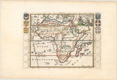
MAP, Western Africa, LangenesWestern Africa. Barent Langenes, Guinea, 1602 (circa). Hand Color. A beautiful miniature map of the west coast of Africa covering the coast from Liberia to Cameroon. The majority of the place names arSee Sold Price
Late 19th Century Reference Map of AfricaLate 19th-century reference map, No. 15, of Africa showing a smaller map, top right, of Northern Egypt &, bottom left, Liberia & Sierra Leone. 9" X 11 1/4".See Sold Price
WESTERN AFRICA.Kong Mountains.Caravan routes.SlaveTITLE/CONTENT OF MAP: 'Western Africa' The map shows sub-saharan west Africa prior to the later "Scramble for Africa" colonisation. Senegambia is shown, as is the state of Liberia. Ashantee (roughly pSee Sold Price
Afrique. Limba Soulimana #26. Guinea Sierra Leone Liberia. VANDERMAELEN 1827 mapJasper524.5(9.8k)See Sold PriceFeb 28, 2024
West Africa. Liberia Sahara Senegambia Guinea. Mountains of Kong COLTON 1869 mapJasper524.5(9.8k)See Sold PriceFeb 28, 2024
North west Africa. Liberia inset. Sahara Senegambia Guinea. COLTON 1863 mapJasper524.5(9.8k)See Sold PriceFeb 28, 2024
Carte de la Guinée, contenant…'. Guinea & Cape Verde islands. BONNE 1771 mapJasper524.5(9.8k)See Sold PriceFeb 28, 2024
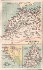
MOROCCO LIBERIA & MAURITIUS. Sierra Leone. BARTHOLOMEW 1886 old antique mapJasper524.5(9.8k)See Sold PriceFeb 28, 2024
WESTERN AFRICA.Kong Mountains.Caravan routes.Slave Coast.TALLIS/RAPKIN 1849 mapJasper524.5(9.8k)See Sold PriceFeb 28, 2024
Partie de la Coste de Guinée' Sierra Leone Liberia coast BELLIN/SCHLEY 1747 mapJasper524.5(9.8k)See Sold PriceFeb 28, 2024
Johnson's Africa. Colonies & tribes. Liberia Nile Delta Cape Colony 1866 mapJasper524.5(9.8k)See Sold PriceFeb 28, 2024
Partie de la Coste de Guinée'. Sierra Leone & Liberia coast. BELLIN 1747 mapJasper524.5(9.8k)See Sold PriceFeb 28, 2024
WESTERN AFRICA.Kong Mountains.Caravan routes.Slave Coast.TALLIS/RAPKIN 1851 mapJasper524.5(9.8k)See Sold PriceFeb 28, 2024
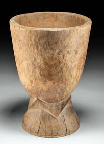
Large 20th C. Liberian Wood Mortar - ex-Arte PrimitivoArtemis Fine Arts4.8(1.4k)See Sold PriceFeb 26, 2024