ATLAS of ANTIENT GEOGRAPHY by SAMUEL BUTLER 1843John McInnis Auctioneers,LLC4.5(505)See Sold PriceFeb 24, 2024
18TH C. ANTIQUE MAP: FRENCH & INDIAN WAR, FRAMEDThomaston Place Auction Galleries4.4(393)See Sold PriceFeb 24, 2024
Rand McNally Railroad Map Cabinet w/ 21 Railroad MapsRail & Road Auctions4.6(165)See Sold PriceMar 08, 2024
Keith Haring - Ink on New York Map, Best Buddies, Inscribed, Signed, and DatedSapphire Auction Gallery4(67)See Sold PriceMar 02, 2024
LATE 17TH C. FRENCH MAP OF THE NEW WORLD BY ALEXIS-HUBERT JAILLOT (1632-1712)Thomaston Place Auction Galleries4.4(393)See Sold PriceFeb 24, 2024
Central Railroad of New Jersey Map of Sandy Hook Route-ca. 1903JM Hobby Supply and Railroad Artifact Auctions4.4(127)See Sold PriceFeb 24, 2024
Lot of Six Mixed Atlas Box Cars-HO Scale-New in BoxJM Hobby Supply and Railroad Artifact Auctions4.4(127)See Sold PriceFeb 25, 2024
Rand McNally/Santa Fe Railroad Map of Iowa-1912JM Hobby Supply and Railroad Artifact Auctions4.4(127)See Sold PriceFeb 24, 2024
NICOLAES VISSCHER (NETHERLANDS, 1618-1709) MAP OF THE NEW WORLDThomaston Place Auction Galleries4.4(393)See Sold PriceFeb 24, 2024
17TH C. WORLD MAP BY NICOLAES VISSCHER (NETHERLANDS, 1618-1709)Thomaston Place Auction Galleries4.4(393)See Sold PriceFeb 24, 2024
Lot of Six Mixed Atlas Cabooses-HO Scale-New in BoxJM Hobby Supply and Railroad Artifact Auctions4.4(127)See Sold PriceFeb 25, 2024
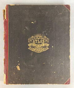
SoldAtlas of Stark County Ohio Combination Atlas Map 1875Atlas of Stark County Ohio Combination Atlas Map 1875: A nice book from 1875. An oversize atlas map of Stark County. By L.H. Everts and Co. There is some water marks on some pages but all of the mapsSee Sold Price
1875 Historical Combination Atlas Map of Stark County Ohio1875 Combination Atlas Map of Stark County, Ohio. Original 1/2 leather, boards detached, corners largely perished. Good internally, with light soiling, some short tears. In spite of the condition, thiSee Sold Price
SoldHistorical Atlas of Licking County, Ohio, 1875, Historical Atlas of Licking County, Ohio, 1875, Everts, L.H. Combination Atlas Map of Licking County, Ohio. 1875. Printed by Thos. Hunter, Phila. 37 hand-colored maps, several double-page.See Sold Price
Combination Atlas Map of Montgomery County Ohio''Combination Atlas Map of Montgomery County Ohio'', L. H. Everts, 1875, 176 pp, including pages 29 1/4, 29 1/2, 36 1/4 and 36 1/2, 14 1/2''w. x 17 1/4''h, hard bound in dark green textured cloth andSee Sold Price
SoldCombination Atlas Map of Montgomery County Ohio''Combination Atlas Map of Montgomery County Ohio'', L. H. Everts, 1875, 176 pp, including pages 29 1/4, 29 1/2, 36 1/4 and 36 1/2, 14 1/2''w. x 17 1/4''h, hard bound in dark green textured cloth andSee Sold Price
Sold1875 Atlas Map of Stark County 1974 ReproductionShowing folds, bends and some tears to edges as seen in photos but pages and maps are in good condition. 17" H x 14" WSee Sold Price
SoldCombination Atlas Map of Medina County Ohio''Combination Atlas Map of Medina County Ohio'', L. H. Everts, Chicago, 1874, all 106 pp present, 14 3/4'' x 17 1/2''h, hard bound in black and green cloth cover with embossed and gilt lettering, someSee Sold Price
SoldCombination Atlas Map of Medina County Ohio''Combination Atlas Map of Medina County Ohio'', L. H. Everts, Chicago, 1874, all 106 pp present, 14 3/4'' x 17 1/2''h, hard bound in black and green cloth cover with embossed and gilt lettering, someSee Sold Price
SoldCombination Atlas Map of Portage County Ohio''Combination Atlas Map of Portage County, Ohio'', L. H. Everts, Chicago, 1874, 148 pp, plus additional 21 pgs, 14 1/4 x 17 1/4''h, hard bound in dark blue green textured cloth and three-quarter leathSee Sold Price
SoldAntique Folio Atlas COMBINATION ATLAS MAP OF SANDUSKYAntique Folio Atlas COMBINATION ATLAS MAP OF SANDUSKY COUNTY OHIO 1874 Elephant Folio Color Maps Fold-Outs Portraits Sketches Lithographic Views Everts Stewart and Co Fremont Rice Riley Jackson ScottSee Sold Price
Sold2 Atlas - Ashland and Medina counties, Ohio2 Atlas- 1.) ''Caldwell's Atlas of Ashland County, Ohio'', J. A. Caldwell, Condit, Ohio, 1874; 2.) ''Combination Atlas Map of Medina County, Ohio'', L. H. Everts, Chicago, Illinois, 1874- both hardbouSee Sold Price
Sold1 vol. (Pennsylvania County Atlas.) Eve1 vol. (Pennsylvania County Atlas.) Everets & Stewart. Combination Atlas Map of Lancaster County, Pennsylvania. Philadelphia: Everets & Stewart, 1875. Folio, orig. cloth, gilt, later cloth spine & corSee Sold Price
SoldCombination Atlas Map of Summit County, 1874Heading: (Ohio) Author: Title: Combination Atlas Map of Summit County Place Published: Philadelphia Publisher:Tackabury, Mead, & Moffett Date Published: 1874 Description: 1See Sold Price
Combination Atlas Map of Summit County, 1874Heading: (Ohio) Author: Title: Combination Atlas Map of Summit County Place Published: Philadelphia Publisher:Tackabury, Mead, & Moffett Date Published: 1874 Description: 1See Sold Price
Sold(OHIO.) Levers, L. H. Combination Atlas Map of(OHIO.) Levers, L. H. Combination Atlas Map of Portage County. Numerous hand-colored maps, lithographed views. Folio, library buckram; ex-library, with small inked stamp on title, otherwise unmarked.See Sold Price
Sold1 vol. Everts and Stewart, pub. Combination Atlas1 vol. Everts and Stewart, pub. Combination Atlas Map of Lancaster County, Pennsylvania. Philadelphia, 1875. Folio, orig. cloth; worn & crudely repaired. 55 hand-colored maps, lithographic views. ContSee Sold Price
SoldTwo Atlases of Pennsylvania: Main Line, Delaware Co."Combination Atlas Map of Delaware County, Pennsylvania", by Everts and Stewart, Philadelphia, 1875, with hand colored maps and lithographic views; "Atlas of Properties on Main Line Pennsylvania RailrSee Sold Price
SoldAtlas of Jackson County Ohio''Atlas of Jackson County Ohio, from Actual Surveys by and under directions of D. J. Lake, C. E.'', Titus, Simmons and Titus, Philadelphia, 1875, all 45 pages present, along with a folding map of RailSee Sold Price
Untitled. [Two Real Estate Plats of Portions of WoodMap: Untitled. [Two Real Estate Plats of Portions of Wood County, Ohio] Date: 1880 Cartographer: ANONYMOUS Size (inches): 12.6x12.25 Traced or transcribed from the Combination atlas of Sandusky, OhioSee Sold Price
SoldNew Century Atlas of Lake County Ohio''New Century Atlas of Lake County Ohio'', Alexander C. Stark, Chief Engineer, Century Map Co., Philadelphia, 1915, 127pp containing 29 maps and 14 pgs of test, atlas folio (17 1/2 x 24''), hard boundSee Sold Price
SoldNew Century Atlas of Lake County Ohio''New Century Atlas of Lake County Ohio'', Alexander C. Stark, chief engineer, Century Map Co., Philadelphia, 1915, all 127 pp present, atlas folio (17 1/2'' x 24''h), hard bound in tan cloth and threSee Sold Price
Sold1875 Atlas of Dauphin County, PennsylvaniaDESCRIPTION: New Historical Atlas of Dauphin, Pennsylvania. Combination Atlas complied, drawn, and published from personal examinations and surveys by Everts and Stewart of Philadelphia, 1875. HardcovSee Sold Price
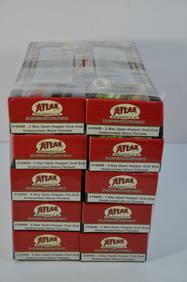
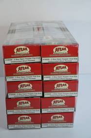
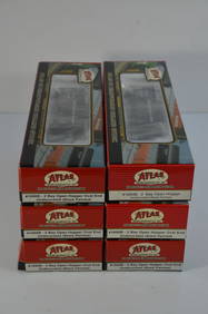
Chesapeake and Ohio RR 10-pack Atlas 2 Bay Open Hoppers-HO Scale-New in BoxJM Hobby Supply and Railroad Artifact Auctions4.4(127)See Sold PriceFeb 25, 2024
Chesapeake and Ohio RR 10-pack Atlas 2 Bay Open Hoppers-HO Scale-New in BoxJM Hobby Supply and Railroad Artifact Auctions4.4(127)See Sold PriceFeb 25, 2024
Chesapeake and Ohio RR 10-Pack Atlas Trainman 9 Panel Hoppers-HO Scale-New in BoxJM Hobby Supply and Railroad Artifact Auctions4.4(127)See Sold PriceFeb 25, 2024
Chesapeake and Ohio RR 4-Pack Atlas TM Cupola Cabooses-HO Scale-New in BoxJM Hobby Supply and Railroad Artifact Auctions4.4(127)See Sold PriceFeb 25, 2024
Chesapeake and Ohio RR 5-Pack Atlas TM Cupola Cabooses-HO Scale-New in BoxJM Hobby Supply and Railroad Artifact Auctions4.4(127)See Sold PriceFeb 25, 2024
Chesapeake and Ohio RR 6-pack Atlas 2 Bay Open Hoppers-HO Scale-New in BoxJM Hobby Supply and Railroad Artifact Auctions4.4(127)See Sold PriceFeb 25, 2024
Chesapeake and Ohio RR 6-pack Atlas 2 Bay Open Hoppers-HO Scale-New in BoxJM Hobby Supply and Railroad Artifact Auctions4.4(127)See Sold PriceFeb 25, 2024
Chesapeake and Ohio RR 6-pack Atlas Extended Vision Cabooses-HO Scale-New in BoxJM Hobby Supply and Railroad Artifact Auctions4.4(127)See Sold PriceFeb 25, 2024
Chesapeake and Ohio RR 7-pack Atlas 2 Bay Open Hoppers-HO Scale-New in BoxJM Hobby Supply and Railroad Artifact Auctions4.4(127)See Sold PriceFeb 25, 2024
Chesapeake and Ohio RR 8-pack Atlas Trainman 9 Panel Hoppers-HO Scale-New in BoxJM Hobby Supply and Railroad Artifact Auctions4.4(127)See Sold PriceFeb 25, 2024
Chesapeake and Ohio RR 8-pack Atlas Trainman 9 Panel Hoppers-HO Scale-New in BoxJM Hobby Supply and Railroad Artifact Auctions4.4(127)See Sold PriceFeb 25, 2024
General Books - Nicolson - The Counties of Britain - A Tudor Atlas by John SpeedTimeLine Auctions Ltd.4.6(183)See Sold PriceMar 08, 2024
1849 Mitchell School ATLAS 24 MAPS America Holy Land France Africa Egypt AsiaSchilb Antiquarian Rare Books4.8(428)See Sold PriceMar 31, 2024
Rand McNally & Co's New Ideal State and County Survey and Atlas 1911North American Artifact Auctions4.7(198)See Sold PriceApr 20, 2024
1872 New Combination Atlas of Lee County Illinois BookMatthew Bullock Auctioneers4.7(1.8k)See Sold PriceFeb 24, 2024
1905 20th Century Atlas of Boone County IllinoisMatthew Bullock Auctioneers4.7(1.8k)See Sold PriceFeb 24, 2024
Francis McNally - Antique Map of Ohio, Indiana & KentuckyProverde Auctions4.3(3)See Sold PriceFeb 28, 2024