ATLAS of ANTIENT GEOGRAPHY by SAMUEL BUTLER 1843John McInnis Auctioneers,LLC4.6(502)See Sold PriceFeb 24, 2024
18TH C. ANTIQUE MAP: FRENCH & INDIAN WAR, FRAMEDThomaston Place Auction Galleries4.4(386)See Sold PriceFeb 24, 2024
Rand McNally Railroad Map Cabinet w/ 21 Railroad MapsRail & Road Auctions4.6(165)See Sold PriceMar 08, 2024
Keith Haring - Ink on New York Map, Best Buddies, Inscribed, Signed, and DatedSapphire Auction Gallery4(67)See Sold PriceMar 02, 2024
LATE 17TH C. FRENCH MAP OF THE NEW WORLD BY ALEXIS-HUBERT JAILLOT (1632-1712)Thomaston Place Auction Galleries4.4(386)See Sold PriceFeb 24, 2024
Central Railroad of New Jersey Map of Sandy Hook Route-ca. 1903JM Hobby Supply and Railroad Artifact Auctions4.4(126)See Sold PriceFeb 24, 2024
Lot of Six Mixed Atlas Box Cars-HO Scale-New in BoxJM Hobby Supply and Railroad Artifact Auctions4.4(126)See Sold PriceFeb 25, 2024
Rand McNally/Santa Fe Railroad Map of Iowa-1912JM Hobby Supply and Railroad Artifact Auctions4.4(126)See Sold PriceFeb 24, 2024
NICOLAES VISSCHER (NETHERLANDS, 1618-1709) MAP OF THE NEW WORLDThomaston Place Auction Galleries4.4(386)See Sold PriceFeb 24, 2024
17TH C. WORLD MAP BY NICOLAES VISSCHER (NETHERLANDS, 1618-1709)Thomaston Place Auction Galleries4.4(386)See Sold PriceFeb 24, 2024
Lot of Six Mixed Atlas Cabooses-HO Scale-New in BoxJM Hobby Supply and Railroad Artifact Auctions4.4(126)See Sold PriceFeb 25, 2024
SoldAtlas of Plymouth County, 1879, published by Geo.H. Walker and Co. 61 Hanover St, Boston. 92 pages plus 6 pages in the back of advertising. Numerous maps and plates of Plymouth County. 18 1/2" x 15". Appears to be in good, as-found condition with noSee Sold Price
SoldAtlas of Plymouth County Massachusetts 1879This nice vintage atlas reads on the front page Atlas of Plymouth County Massachusetts complied from recent and actual surveys and records under the direction of the publishers, published by Geo. H. WSee Sold Price
SoldBOUND ATLAS OF PLYMOUTH COUNTY 1879 PUBLISHEDBY GEORGE WALKER & CO., BOSTON; 92 PAGES WITH 5 PAGES OF ADS IN THE REAR; 18" X 15"; HAS ORIGINAL CLOTH BINDING WITH GILDED LETTERING; SPINE IS BROKEN AND THE FRONT IS DETACHED; FRONT PAGE HAS BEEN FOSee Sold Price
Sold1879 BOUND ATLAS OF PLYMOUTH COUNTYAtlas of Plymouth County, Massachusetts, 1879, published by George H. Walker & Co., Boston, Mass. Rough condition covers and detached, Missing some front pages. Loose first 10 pages. Hand coloredmaps.See Sold Price
SoldGEORGE WALKER ATLAS BOOK OF PLYMOUTH COUNTY:Ca. 1879. Atlas of Plymouth County, Massachusetts, 1879 First Edition published by George H. Walker & Co. Boston, Mass. Consists of 92 pages along with four pages of lists of Manufacturers and MerchanSee Sold Price
SoldPLYMOUTH COUNTY 1879 HAND COLORED ATLAS BOOK:Atlas of Plymouth County, Massachusetts, 1879 First Edition published by George H. Walker & Co. Boston, Mass. Consists of 92 pages along with four pages of lists of Manufacturers and Merchants. IncludSee Sold Price
Sold19TH C. BOUND ATLAS; MAPS OF TOWNS Atlas of Plymouth19TH C. BOUND ATLAS; MAPS OF TOWNS Atlas of Plymouth County, Massachusetts, 1879, published by George H. Walker & Co., Boston, Mass., 92 pgs; along with four pages of lists of Manufacturers and MerchaSee Sold Price
1879 MASS. COLORED MAP BY WALKERAntique colored map WALKERS RAILROAD, COUNTY & POST OFFICE MAP OF MASSACHUSETTS, published Boston 1879 by Geo. Walker. 17.5 x 27.5 image, framed 19.5 x 29.5 inches.See Sold Price
SoldMASSACHUSETTS ATLASES 1879 & 1891Two New England atlases, one atlas of Massachusetts 1891, one atlas of Plymouth County 1879, two journals of Stanley Alger, who worked for the government during World War II, photo of family homesteadSee Sold Price
SoldAtlas of Plymouth CountyGeorge H. Walker and Co., Boston, atlas of Plymouth County, dated 1879, with center fold panorama of Nantasket beach, 18 1/2" h x 15" w. Provenance: MA estate.See Sold Price
SoldGroup Of Three Antique/Vintage American BooksConsisting of two Waverley Novels Volume VI and IV, published by Collier Publisher and one Standard Atlas of Fulton County, Illinois, published by Geo. A. Ogle & Co. Publishers & Engravers Chicago inSee Sold Price
Sold1879 BOUND "ATLAS OF PLYMOUTH COUNTY"BY GEORGE H. WALKER & CO.; GOOD OVERALL CONDITION; PAGES 9, 12, 13, 16, 24, 28, 37, 38, 39, 40, 76 ARE INTENTIONALLY LEFT BLANK.See Sold Price
Sold1908 Boston Atlas1908 Boston Atlas. "ATLAS OF Middlesex County, Massachusetts/VOLUME III, Published by GEO. H. WALKER & CO., 221 High Street, BOSTON 1908". 22 1/2" x 17 1/4".See Sold Price
SoldSTANDARD ATLAS OF WALLA WALLA COUNTY. LARGE BOOKSTANDARD ATLAS OF WALLA WALLA COUNTY. LARGE BOOK PUBLISHED BY GEO.A. OGLE &CO. CHICAGO, ILL. 1909. SOME DAMAGE.See Sold Price
Sold1909 Standard Atlas of Walla Walla CountyIncluding A Plat Book of the Villages, Cities, and Townships of the County, Published by Geo. A. Ogle & Co., Poor to Fair Condition See Sold Price
SoldTHREE 19TH CENTURY MISSOURI COUNTY ATLASESIncludes a 'Standard Atlas of Callaway County, Missouri, including a Plat Book,' published by Geo. A. Ogle & Co., 1919, no covers. 'Atlas Map of Pike County, Missouri,' from the census of 1870, with bSee Sold Price
Sold1880 BOUND ATLAS OF BARNSTABLE COUNTY, PUBLISHEDBY GEO. H WALKER, 81 MILK ST, BOSTON, 18 1/2" X 15". 81 NUMBERED PAGES AND 2 PAGES OF ADVERTISING IN REAR. THERE ARE SOME WATER STAINS ON PAGES, MOSTLY ON ENDS AND SIDES. THE SPINE IS SPLIT AND BOARDSSee Sold Price
SoldMidwest US Maps (8) (63200)8 maps featuring the Midwestern states. 1) Ohio by Counties with Railroads. Published by Geo. F. Cram, Chicago, IL. 1883. Approximately 14.5" x 21.5." 2) A New Map of the State of Ohio. 1856. PublisheSee Sold Price
Midwest US Maps (8) (63200)8 maps featuring the Midwestern states. 1) Ohio by Counties with Railroads. Published by Geo. F. Cram, Chicago, IL. 1883. Approximately 14.5" x 21.5." 2) A New Map of the State of Ohio. 1856. PublisheSee Sold Price
Scarce 1879 pocket map of KansasVery uncommon and early Township, County & Railroad Map of Kansas published 1879 by Rand McNally & Co. Printed outline color with larger color area in hachures. Railway lines labeled and in bright redSee Sold Price
New sectional map of the State of MissouriTitle: New sectional map of the State of Missouri Publication Date:1874 Cartographer: Geo. F. Cram Publisher: GEO. F. CRAM Brief Description: engraved from official draughts of each county published bSee Sold Price
SoldAntique Map Prince County, PEI, 1879Title: County of Prince, Prince Edward Island. Published in the Atlas of the Maritime Provinces of the Dominion of Canada by Roe Brothers of St. John, New Brunswick. Date: 1879.See Sold Price
SoldAN ANTIQUE POCKET MAP, "Railroad and County Map ofAN ANTIQUE POCKET MAP, "Railroad and County Map of Texas," CHICAGO, LATE 19TH CENTURY, color ink engraving, a page fragment from an atlas, plates 198-199, engraved and published by Geo. F. Cram., withSee Sold Price
SoldRare map of Stanislaus County, CaliforniaHeading: (California - Stanislaus County) Author: Macomber, Geo. D., County Surveyor Title: Stanislaus County Place Published: [Modesto?] Publisher: Date Published: 1941 Description: </See Sold Price
1850 ENORMOUS Italian Architecture Vannini Florence Italy RARE Renaissance ARTSchilb Antiquarian Rare Books4.8(421)See Sold PriceMar 31, 2024
Rand McNally & Co's New Ideal State and County Survey and Atlas 1911North American Artifact Auctions4.6(182)See Sold PriceApr 20, 2024
[BASEBALL]. Group of Three 1907 Championship Chicago White ...Potter & Potter Auctions4.6(539)See Sold PriceMar 07, 2024
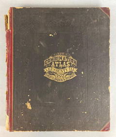
1872 New Combination Atlas of Lee County Illinois BookMatthew Bullock Auctioneers4.7(1.8k)See Sold PriceFeb 24, 2024
Carey, pub. 1796 - A Chart of the West IndiesTrillium Antique Prints & Rare Books4.5(30)See Sold PriceFeb 24, 2024
Carey, pub. 1796 - Map of the State of MarylandTrillium Antique Prints & Rare Books4.5(30)See Sold PriceFeb 24, 2024
Carey, pub. 1796 - Map of GeorgiaTrillium Antique Prints & Rare Books4.5(30)See Sold PriceFeb 24, 2024
Carey, pub. 1796 - Map of The State of South CarolinaTrillium Antique Prints & Rare Books4.5(30)See Sold PriceFeb 24, 2024
Carey, pub. 1796 - Map of KentuckyTrillium Antique Prints & Rare Books4.5(30)See Sold PriceFeb 24, 2024
Carey, pub. 1796 - Map of the Tennassee State formerly part of North Carolina (Tennessee)Trillium Antique Prints & Rare Books4.5(30)See Sold PriceFeb 24, 2024
De Jode, Rare, pub. 1593 - Map of the Czech Republic or Kingdom of Bohemia (Chorographia insignisTrillium Antique Prints & Rare Books4.5(30)See Sold PriceFeb 24, 2024
De Jode, Rare, pub. 1593 - Map of the Middle East, Eastern Asia (Primae Partis Asiae accurataTrillium Antique Prints & Rare Books4.5(30)See Sold PriceFeb 24, 2024
James Humbert Craig ( Irish 1877-1944) Lithograph Arranmore from the Rosses, County Donegal publisheHannam's Auctioneers Ltd4.3(386)See Sold PriceMar 01, 2024
Vintage Street Map of Pittsburgh, Pennsylvania - Rand McNallyProverde Auctions4.3(3)See Sold PriceFeb 28, 2024


![[BASEBALL]. Group of Three 1907 Championship Chicago White ... (1 of 2)](https://p1.liveauctioneers.com/928/318880/171361360_1_x.jpg?height=282&quality=70&version=1707501302)