ATLAS of ANTIENT GEOGRAPHY by SAMUEL BUTLER 1843John McInnis Auctioneers,LLC4.5(505)See Sold PriceFeb 24, 2024
18TH C. ANTIQUE MAP: FRENCH & INDIAN WAR, FRAMEDThomaston Place Auction Galleries4.4(393)See Sold PriceFeb 24, 2024
Rand McNally Railroad Map Cabinet w/ 21 Railroad MapsRail & Road Auctions4.6(165)See Sold PriceMar 08, 2024
Keith Haring - Ink on New York Map, Best Buddies, Inscribed, Signed, and DatedSapphire Auction Gallery4.1(67)See Sold PriceMar 02, 2024
LATE 17TH C. FRENCH MAP OF THE NEW WORLD BY ALEXIS-HUBERT JAILLOT (1632-1712)Thomaston Place Auction Galleries4.4(393)See Sold PriceFeb 24, 2024
Central Railroad of New Jersey Map of Sandy Hook Route-ca. 1903JM Hobby Supply and Railroad Artifact Auctions4.4(127)See Sold PriceFeb 24, 2024
Lot of Six Mixed Atlas Box Cars-HO Scale-New in BoxJM Hobby Supply and Railroad Artifact Auctions4.4(127)See Sold PriceFeb 25, 2024
Rand McNally/Santa Fe Railroad Map of Iowa-1912JM Hobby Supply and Railroad Artifact Auctions4.4(127)See Sold PriceFeb 24, 2024
NICOLAES VISSCHER (NETHERLANDS, 1618-1709) MAP OF THE NEW WORLDThomaston Place Auction Galleries4.4(393)See Sold PriceFeb 24, 2024
17TH C. WORLD MAP BY NICOLAES VISSCHER (NETHERLANDS, 1618-1709)Thomaston Place Auction Galleries4.4(393)See Sold PriceFeb 24, 2024
Lot of Six Mixed Atlas Cabooses-HO Scale-New in BoxJM Hobby Supply and Railroad Artifact Auctions4.4(127)See Sold PriceFeb 25, 2024
SoldAtlas minor, of Joh. Mich. Probst, 18. th c., map ofAtlas minor, of Joh. Mich. Probst, 18. th c., map of Austria, Australia and Scandinavia attached, 1870 new in paper binding, age related damaged, not exactly complete, colouredSee Sold Price
Sold18th c. Florida Map - Herman MollFLORIDA, CALLED BY YE FRENCH LOUISIANA & C., hand colored engraved map by Herman Moll (1688-1732), originally appeared in Moll's Atlas Minor (1736). 8 1/8" x 11" plate, 8 3/8" x 11 1/8" sight, 15" x 1See Sold Price
Nine -18th c. Italian map Photogravures circa 1900Nine total color stone engraved maps, some minor edge damage to some, depicting 18th century Italy and EuropeSee Sold Price
Sold18th c. French map18th c. French map- ''Partie Meridonale de Picardie''- engraving with hand-coloring, center fold as should be, minor paper foxing, staining along upper edge, other minor soiling and staining throughouSee Sold Price
SoldCopper engraving map, Joh. Baptist Homann NurembergCopper engraving map, Joh. Baptist Homann Nuremberg, 18th C., Judaea and Palaestina, partly colored, two cartouches, upper with representation of Moses, who receives the Ten Commandments, smoothed creSee Sold Price
Sold18TH C ATLAS MAP BY JOHANN HOMANN - HUNGARYTitled Hungariae by German Cartographer Johann Homann (1663 - 1724), published by Homannianis Heredibus in 1752 showing Hungary, Bulgaria, Romania & Serbia. Map is framed, shows foxing & has a tear. MSee Sold Price
'Carte de l'Egypte Ancienne et Moderne' 18th C MapCarte de l'Egypte Ancienne et Moderne' Map. Large antique 18th C. atlas map, printed on thick, good quality paper with original outline hand colour/color and decorative title cartouche. Artist/CartogrSee Sold Price
Six various maps related to the Netherlands and a re-edition of the Ferraris atlas, 18th C. andFull title: Six various maps related to the Netherlands and a re-edition of the Ferraris atlas, 18th C. and later Description: The map: 27,2 x 19,7 cm (the largest map) Paper: 29,5 x 23 cm Frame: 43 xSee Sold Price
SoldSeutter, Hand Colored Map, Asia Minor, 18th C.German, circa 1770. "Natoliae olim Asiae Minoris Tabula per Matth. Seutterum"-circa 1770, hand colored copperplate cartographic engraving by Georg Matthäus Seutter (German, 1678-1757) published in AuSee Sold Price
Sold18th C. Map, Engraving on Paper, Chios Greece18th Century map, engraving on paper, Chios Harbor, Greece, image 12 1/2" x 18 1/4", sheet 19 1/4" x 14 1/4", mounted on paper board. Folded in center; margins soiled; minor surface dirt.See Sold Price
Sold18th c. "Map of the Southern States of America,"18th c. "Map of the Southern States of America,"copperplate engraving by John Russell, from THE AMERICAN ATLAS (London: H. D. Symonds, 1795-95), shown are Maryland, Virginia, the Carolinas, Georgia, KSee Sold Price
Sold18th c. map of North America- H. Popple18th c, map by Henry Popple- ''Nova Mappa Geographica Americae Septentrionalis''- engraving with original hand-coloring, minor vertical printer's wrinkle from Central America to Lake Erie, large margiSee Sold Price
Sold18th C. map of BermudaCarte des Isles Bermudes ou de Sommer, Paris 1764. Hand colored copperplate engraving From Bellin's Petit atlas maritime.Tome I N.48 Plate XXXIII. Frame under glass, not inspected out of the frame. 8"See Sold Price
SoldVERY EARLY 18TH C. MAP OF BERMUDA "Bermudes ou Iles deVERY EARLY 18TH C. MAP OF BERMUDA "Bermudes ou Iles de Sommer...", by Pieter Van Der AA, Leyden, c. 1700-1715, lightly colored with green and red, central atlas fold line and some toning, good bordersSee Sold Price
18th c. Map of the Southern States of America18th c. ''Map of the Southern States of America,'', engraving by John Russell, 1795, from the ''American Atlas'' (London H. D. Symonds, 1795-95), mended 3 inch tear on right side, narrow right marginsSee Sold Price
SoldFrench 18th C. Map of the WorldGROUP LOT OF 6 MAPS WITH FINE ORIGINAL COLOR Louis Brion de la Tour (c. 1743 – 1803) from Louis C. Desnos' Atlas General Engraved maps with hand color in full Paris, 1779 (1783) each approximately 2See Sold Price
Sold18th c Map - Italy Ducato de Urbinofrom an 18th c Atlas possibly Dutch engraved and hand colored framed & glazedSee Sold Price
'Carte de l'Egypte Ancienne et Moderne' 18th C Map'Carte de l'Egypte Ancienne et Moderne' Map. Large antique 18th century atlas map, printed on thick, good quality paper with original outline hand colour/color and decorative title cartouche. Artist/CSee Sold Price
18th C. Map Italy: Etats du Roy de SardaigneHand colored copper engraving atlas map on laid paper, 1787, by Clouet, J. B. L. (Jean-Baptiste Louis,) entitled "Etats du Roy de Sardaigne. (with) Isle de Sardaigne". A beautiful map, with inset, shoSee Sold Price
Sold18th C. Map of LouisianaAn 18th C. hand-colored engraved map by Emanuel Bowen, titled "A New and Accurate Map of Louisiana with Part of Florida and Canada, and the Adjacent Countries", Plate 59. Likely from the "Complete AtlSee Sold Price
SoldFRAMED RARE 18TH C. MAP OF CORFU BY HOMANNSPlan de la Place de Corfu avec ses Environs Assiegee Par les Infideles, tranchee ouverte le 25me Juillet jusqu'au 22 me d'Aout, Iour de la Fuite des Ottomans". Homann, J. B. Circa 1740. Hand colored cSee Sold Price
Sold18TH C MAP, NORTH AMERICA, UNITED STATES & MEXICOJohann Baptist Homann (German, 1664-1724). "Regni Mexicani seu Novae Hispaniae" - circa 1725, engraving with hand coloring. Approx. 20.75" x 24" (sheet) Item from the Estate of Forest "Tag" Hunter, AtSee Sold Price
Sold18th c. Map of America- Emanuel Bowen18th c. Map- ''A New and Accurate Map of America''- engraved map, 1748, from John Harris- ''Complete Collection of Voyages and Travels'', short repaired separation at top of centerfold. 14 3/8 x 17 5/See Sold Price
Sold18th c. map of Africa showing known kingdomsHeading: Author: Robert de Vaugondy, Gilles and Didier Title: L'Afrique dressée, sur les relations les plus recentes, et assujettie aux observations astronomiques Place Published: [Paris] Publisher:See Sold Price
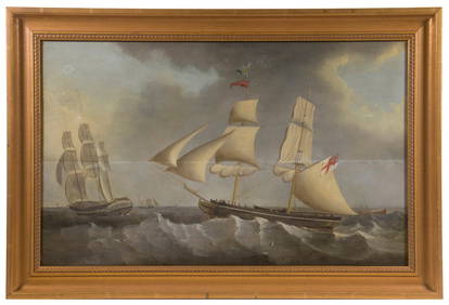
LATE 18TH C. OIL PAINTING OF BRITISH MAN-O-WARThomaston Place Auction Galleries4.4(393)See Sold PriceFeb 24, 2024
PR ENGLISH GEORGE III STAFFORDSHIRE ENAMEL CANDLESTICKSThomaston Place Auction Galleries4.4(393)See Sold PriceFeb 24, 2024
EARLY 18TH C. DUTCH CHART OF PACIFIC OCEAN BY FREDERIK DE WIT (1629-1706) WITH CALIFORNIA AS ANThomaston Place Auction Galleries4.4(393)See Sold PriceFeb 24, 2024
LATE 16TH C. MAP OF SCOTLAND BY MERCATOR, FRAMEDThomaston Place Auction Galleries4.4(393)See Sold PriceFeb 24, 2024
18TH C. ANTIQUE MAP: FRENCH & INDIAN WAR, FRAMEDThomaston Place Auction Galleries4.4(393)See Sold PriceFeb 24, 2024
PAIR (18th c) OF FLINTLOCK DUELING PISTOLSJohn McInnis Auctioneers,LLC4.5(505)See Sold PriceFeb 24, 2024
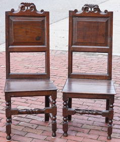
PAIR OF (18th c) ENGLISH OAK SIDE CHAIRSJohn McInnis Auctioneers,LLC4.5(505)See Sold PriceFeb 24, 2024
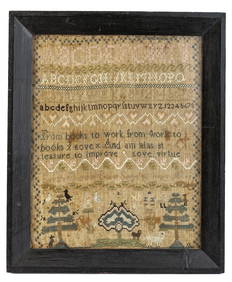
(18th c) SAMPLER by SARAH BROWN born 1780.John McInnis Auctioneers,LLC4.5(505)See Sold PriceFeb 25, 2024
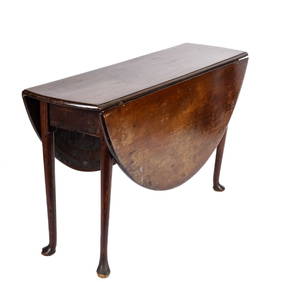
(18th c) QUEEN ANNE MAHOGANY DROP LEAF TABLEJohn McInnis Auctioneers,LLC4.5(505)See Sold PriceFeb 25, 2024
18th C. QUEEN ANNE CHINOISERIE DRESSING MIRRORLewis & Maese Antiques & Auction4.4(527)See Sold PriceFeb 25, 2024
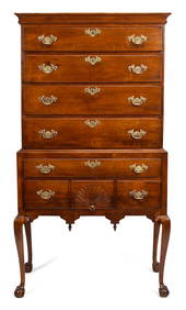
Period 18Th C. Queen Anne Bonnet Top Tiger Maple HighboyRalph Fontaine Heritage Auctions Inc.4.7(236)See Sold PriceFeb 25, 2024
COLONIES FRANÇAISES en AFRIQUE. Africa Sénégal Madagascar. LEVASSEUR c1850 mapJasper524.5(9.9k)See Sold PriceFeb 28, 2024
American Queen Anne Cherry Highboy, Litchfield County, CT, 18th c., H.- 73 in., W.- 41 1/2 in., D.-Crescent City Auction Gallery4.3(231)See Sold PriceMar 09, 2024
Perry, Matthew C. 1856 Large Map. Shah Bay, Lew Chew I. JapanAlbion Auctions4.7(341)See Sold PriceMar 01, 2024
FINE 18TH C. BOSTON CHIPPENDALE MAPLE HIGHBOY.William Smith Auctions4.6(147)See Sold PriceMar 06, 2024
18TH C. VA QUEEN ANNE MAHOGANY SMOKING CHAIR.William Smith Auctions4.6(147)See Sold PriceMar 06, 2024
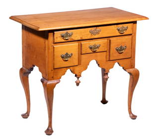
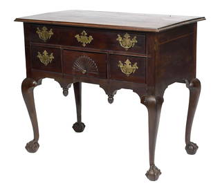
18TH C. CHIPPENDALE MA CARVED DRESSING TABLE.William Smith Auctions4.6(147)See Sold PriceMar 06, 2024
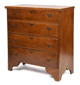
18TH C. QUEEN ANNE TIGER MAPLE BLANKET CHEST.William Smith Auctions4.6(147)See Sold PriceMar 06, 2024