ATLAS of ANTIENT GEOGRAPHY by SAMUEL BUTLER 1843John McInnis Auctioneers,LLC4.6(502)See Sold PriceFeb 24, 2024
18TH C. ANTIQUE MAP: FRENCH & INDIAN WAR, FRAMEDThomaston Place Auction Galleries4.4(386)See Sold PriceFeb 24, 2024
Rand McNally Railroad Map Cabinet w/ 21 Railroad MapsRail & Road Auctions4.6(165)See Sold PriceMar 08, 2024
Keith Haring - Ink on New York Map, Best Buddies, Inscribed, Signed, and DatedSapphire Auction Gallery4(67)See Sold PriceMar 02, 2024
LATE 17TH C. FRENCH MAP OF THE NEW WORLD BY ALEXIS-HUBERT JAILLOT (1632-1712)Thomaston Place Auction Galleries4.4(386)See Sold PriceFeb 24, 2024
Central Railroad of New Jersey Map of Sandy Hook Route-ca. 1903JM Hobby Supply and Railroad Artifact Auctions4.4(126)See Sold PriceFeb 24, 2024
Lot of Six Mixed Atlas Box Cars-HO Scale-New in BoxJM Hobby Supply and Railroad Artifact Auctions4.4(126)See Sold PriceFeb 25, 2024
Rand McNally/Santa Fe Railroad Map of Iowa-1912JM Hobby Supply and Railroad Artifact Auctions4.4(126)See Sold PriceFeb 24, 2024
NICOLAES VISSCHER (NETHERLANDS, 1618-1709) MAP OF THE NEW WORLDThomaston Place Auction Galleries4.4(386)See Sold PriceFeb 24, 2024
17TH C. WORLD MAP BY NICOLAES VISSCHER (NETHERLANDS, 1618-1709)Thomaston Place Auction Galleries4.4(386)See Sold PriceFeb 24, 2024
Lot of Six Mixed Atlas Cabooses-HO Scale-New in BoxJM Hobby Supply and Railroad Artifact Auctions4.4(126)See Sold PriceFeb 25, 2024
Arrowsmith: Antique Map of Egypt, Nile Valley, 1828TITLE/CONTENT OF MAP: 'Egypt' Nile Valley. Nubia. Red Sea. Bahri Vostani Sinai. DATE PRINTED: 1828 IMAGE SIZE: Approx 30.5 x 23.5cm, 12 x 9.25 inches (Large) TYPE: Antique copperplate map CONDITION: GSee Sold Price
SoldMallet: Antique Map of Ancient Egypt & Nile Valley 1683Title of the Map: 'Aegypte Ancienne' Nile valley. Shows towns. Date Printed: 1683 Image Size: Approx Overall page size 13 x 21cm approximately (5 x 8 inches); image size 10.5 x 14.5cm approximately (4See Sold Price
Arrowsmith: Antique Map of Ancient Egypt, 1828TITLE/CONTENT OF MAP: 'Aegyptus; Vel Regio, quam a Tachompso Insula ad Mare Internum Nilus interluit ' DATE PRINTED: 1828 IMAGE SIZE: Approx 31.0 x 25.5cm, 12.25 x 10 inches (Large) TYPE: Antique coppSee Sold Price
SoldSDUK: Antique Map of Ancient Egypt, 1846Title/Content of Map: 'ANCIENT EGYPT' Nile Valley ancient names & sites. Original colour. Date Printed: This map was originally engraved in 1831. This date is printed on the map. This edition of the mSee Sold Price
Mallet: Antique Map of Ancient Egypt, 1683Title of the Map: 'Aegypte Ancienne' ANCIENT EGYPT. Nile valley. Shows towns. Date Printed: 1683 Image Size: Approx Overall page size 13 x 21cm approximately (5 x 8 inches); image size 10.5 x 14.5cm aSee Sold Price
Aegyptus. Ancient Egypt. Nile valley. BONNE 1789 oldTITLE/CONTENT OF MAP: Aegyptus [Egypt] DATE PRINTED: 1789 IMAGE SIZE: Approx 36.0 x 25.0cm, 14.25 x 9.75 inches (Large); Please note that this is a folding map. TYPE: Antique 18th century copperplateSee Sold Price
NUBIA. 'Nubie'. Nile Valley. Sudan Ethiopia Egypt. MALLET 1683 old antique mapTITLE OF THE MAP: 'Nubie' (De L'Afrique) Shows the Blue Nile, although it does not indicate its source in Lake Tana. It does not show the White Nile, the source of which was not discovered until the 1See Sold Price
Aegyptus. Ancient Egypt. Nile valley. BONNE 1789 oldTITLE/CONTENT OF MAP: 'Aegyptus [Egypt]' DATE PRINTED: 1789 IMAGE SIZE: Approx 36.0 x 25.0cm, 14.25 x 9.75 inches (Large); Please note that this is a folding map. TYPE: Antique 19th century copperplatSee Sold Price
Arrowsmith: Antique Map of Palestine, 1828TITLE/CONTENT OF MAP: 'Southern Syria, or the Countries watered by the Jordan' Jordan valley. Levant. Dead Sea. DATE PRINTED: 1828 IMAGE SIZE: Approx 31.0 x 23.0cm, 12.25 x 9 inches (Large) TYPE: AntiSee Sold Price
SoldThomson: Antique Mpa of Egypt. Nile Valley, 1817TITLE/CONTENT OF MAP: 'Egypt' The map is noteworthy for showing the return route of Eyles Irwin, an Irish poet and civil servant, through Egypt from India, where he been in the service of the East IndSee Sold Price
Egypt. Nile valley Sinai Red Sea Gulf of Aqaba SharmTITLE/CONTENT OF MAP: 'Egypt' Date: 1896 IMAGE SIZE: Approx 41.0 x 34.0cm, 16.25 x 13.25 inches (Large) TYPE: Large (folio) antique atlas map CONDITION: Good; suitable for framing. VERSO: There is notSee Sold Price
SoldArrowsmith: Antique Map of Northern Italy, 1828TITLE/CONTENT OF MAP: 'North Italy' Papal States. Sardinia Lombardy Tuscany. DATE PRINTED: 1828 IMAGE SIZE: Approx 24.5 x 31.0cm, 9.5 x 12.25 inches (Large) TYPE: Antique copperplate map CONDITION: GoSee Sold Price
Sold4v Sandford PALEOLITHIC MAN NILE VALLEY Egypt MapWe at CNY Book Auctions are pleased to offer a large selection of archaeological and anthropological titles, along with works in related fields. Other subjects include sciences, medicine, mathematics,See Sold Price
Arrowsmith: Antique Map of Northern Africa, 1828TITLE/CONTENT OF MAP: 'Northern Africa' Maghreb.Marocco Algiers Tunis Tripoli Barca. DATE PRINTED: 1828 IMAGE SIZE: Approx 26.0 x 32.0cm, 10.25 x 12.75 inches (Large) TYPE: Antique copperplate map CONSee Sold Price
Arrowsmith: Antique Map of Central Europe, 1828TITLE/CONTENT OF MAP: 'Southern Germany, with parts of Hungary, Turkey and Italy' DATE PRINTED: 1828 IMAGE SIZE: Approx 26.0 x 28.5cm, 10.25 x 11.25 inches (Large) TYPE: Antique copperplate map CONDITSee Sold Price
Arrowsmith: Antique Map of Ancient Europe, 1828TITLE/CONTENT OF MAP: 'Europa; Cum Insulis et Regionibus intra Paludem Maeotida et Mare Hyrcanum sitis' DATE PRINTED: 1828 IMAGE SIZE: Approx 26.0 x 32.0cm, 10.25 x 12.5 inches (Large) TYPE: Antique cSee Sold Price
Arrowsmith: Antique Map of Ancient World, 1828TITLE/CONTENT OF MAP: 'Orbis Veteribus Notus' Eastern Hemisphere. DATE PRINTED: 1828 IMAGE SIZE: Approx 28.0 x 25.0cm, 11 x 10 inches (Large) TYPE: Antique copperplate map CONDITION: Good; suitable foSee Sold Price
Arrowsmith: Antique Map of South Italy, 1828TITLE/CONTENT OF MAP: 'South Italy' General map. Sardinia Sicily. DATE PRINTED: 1828 IMAGE SIZE: Approx 25.5 x 33.5cm, 10 x 13.25 inches (Large) TYPE: Antique copperplate map CONDITION: Good; suitableSee Sold Price
Hall: Antique Map of Egypt, Red Sea Nile, 1829TITLE/CONTENT OF MAP: 'Egypt' This fascinating map covers Egypt and the Red Sea including the Gulf of Aqaba and the Gulf of Suez. Tiran and Sanafir Islands are marked as "Pirates Isles". The town of ASee Sold Price
Arrowsmith: Antique Map of France & Benelux, 1828TITLE/CONTENT OF MAP: 'France and the Netherlands, with a part of Switzerland' DATE PRINTED: 1828 IMAGE SIZE: Approx 31.0 x 26.5cm, 12.25 x 10.5 inches (Large) TYPE: Antique copperplate map CONDITION:See Sold Price
Arrowsmith: Antique Map of Southern Germany, 1828Title/Content of Map: Central Europe 'Southern Germany, with parts of Hungary, Turkey and Italy' Date Printed: 1828 Image Size: Approx 26.0 x 28.5cm, 10.25 x 11.25 inches (Large) Type: Antique copperpSee Sold Price
Arrowsmith: Antique Map of Ancient Germnay, 1828TITLE/CONTENT OF MAP: 'Germania; Vel Regiones intra Rhenum f1. Oceanum, Sinum Codanum, Vistulam f1. Montes Sarmaticos et Danubium f1. Sitae' DATE PRINTED: 1828 IMAGE SIZE: Approx 27.0 x 33.0cm, 10.5 xSee Sold Price
SoldArrowsmith: Antique Map of Ancient Germany, 1828TITLE/CONTENT OF MAP: 'Germania; Vel Regiones intra Rhenum f1. Oceanum, Sinum Codanum, Vistulam f1. Montes Sarmaticos et Danubium f1. Sitae' DATE PRINTED: 1828 IMAGE SIZE: Approx 25.5 x 28.5cm, 10 x 1See Sold Price
Arrowsmith: Antique Map of Northern Germany, 1828TITLE/CONTENT OF MAP: 'Northern Germany' States. Free Cities. Switzerland Austria. DATE PRINTED: 1828 IMAGE SIZE: Approx 25.5 x 31.0cm, 10 x 12.25 inches (Large) TYPE: Antique copperplate map CONDITIOSee Sold Price
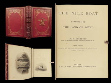
1880 Niles Boat Egypt Voyages Sphinx Pyramids Valley of Kings Illustrated MAPSSchilb Antiquarian Rare Books4.8(421)See Sold PriceMar 31, 2024
Battle of the Nile: Disposition of the English & French Fleets, at the Commencement of the Action,Trillium Antique Prints & Rare Books4.5(30)See Sold PriceFeb 24, 2024
Arrowsmith & Lewis - Map of PolynesiaTrillium Antique Prints & Rare Books4.5(30)See Sold PriceFeb 24, 2024
Arrowsmith & Lewis - Map of North AmericaTrillium Antique Prints & Rare Books4.5(30)See Sold PriceFeb 24, 2024
Arrowsmith & Lewis - Map of the World on Mercator's ProjectionTrillium Antique Prints & Rare Books4.5(30)See Sold PriceFeb 24, 2024
Arrowsmith & Lewis - Map of LouisianaTrillium Antique Prints & Rare Books4.5(30)See Sold PriceFeb 24, 2024
Arrowsmith & Lewis - Map of the United StatesTrillium Antique Prints & Rare Books4.5(30)See Sold PriceFeb 24, 2024
West Africa by Arrowsmith & Lewis 1812 old antique vintage map plan chartJasper524.5(9.8k)See Sold PriceFeb 28, 2024
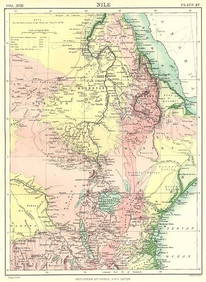
NILE VALLEY. Sudan Tanzania Ethiopia Uganda Lake Victoria. Britannica. 1898 mapJasper524.5(9.8k)See Sold PriceFeb 28, 2024
ANCIENT AFRICA cum Aegypto et Insulis. Nigritae Aethiopia. ARROWSMITH 1828 mapJasper524.5(9.8k)See Sold PriceFeb 28, 2024
NILE VALLEY. Upper & Lower. Egypt Sinai Nubia Sudan Abyssinia. BLACKIE 1886 mapJasper524.5(9.8k)See Sold PriceFeb 28, 2024
NORTH AFRICA. Morocco Algeria Tunis Tunisia Egypt. Cairo. BARTHOLOMEW 1912 mapJasper524.5(9.8k)See Sold PriceFeb 28, 2024
NORTH AFRICA. Morocco Algeria Tunis Tunisia Egypt. Cairo. BARTHOLOMEW 1901 mapJasper524.5(9.8k)See Sold PriceFeb 28, 2024
NILE VALLEY. Upper & Lower. Egypt Sinai Nubia Sudan Abyssinia. BLACKIE 1882 mapJasper524.5(9.8k)See Sold PriceFeb 28, 2024
NORTH AFRICA. Barbary. Morocco Tunisia Libya Egypt. 'Barbarie'. MALLET 1683 mapJasper524.5(9.8k)See Sold PriceFeb 28, 2024
NORTH EAST AFRICA. Libya Egypt Sudan Ethiopia Ubangi-Shari Chad 1952 old mapJasper524.5(9.8k)See Sold PriceFeb 28, 2024
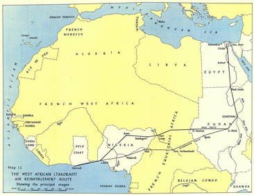
West Africa WW2 Nigeria Sudan Egypt. Takoradi air reinforcement route 1954 mapJasper524.5(9.8k)See Sold PriceFeb 28, 2024
NORTH AFRICA BARBARY. Parts of Tripoli (Libya) & Egypt. Tribes. SDUK 1848 mapJasper524.5(9.8k)See Sold PriceFeb 28, 2024
ANCIENT NORTH AFRICA Septentrionalis. Mauretania Tripolitana ARROWSMITH 1828 mapJasper524.5(9.8k)See Sold PriceFeb 28, 2024
NUBIA. 'Nubie'. Nile Valley. Sudan Ethiopia Egypt. MALLET 1683 old antique mapJasper524.5(9.8k)See Sold PriceFeb 28, 2024
Africa by Arrowsmith & Lewis 1812 old antique vintage map plan chartJasper524.5(9.8k)See Sold PriceFeb 28, 2024
Egypte, Nubie et Abissinie. Egypt, Nubia & Abyssinia. Sudan. BONNE 1788 mapJasper524.5(9.8k)See Sold PriceFeb 28, 2024