3 GREAT VINTAGE NECKLACES TALBOTS GUESS DESIGNER COSTUME JEWELRY LOTNoble House Collection Gallery4.5(123)See Sold PriceFeb 28, 2024
GUESS FOOTWEAR Black Heeled Zippered BootsThe Benefit Shop Foundation Inc.4.3(2.9k)See Sold PriceMar 13, 2024
ANTIQUE CHINESE PORCELAIN FAMILLE ROSE MEDALLION BOWLMannys Jewelry4.6(335)See Sold PriceMar 03, 2024
Guess Collection Form Fitting Cowl Neck Dress USAThe Benefit Shop Foundation Inc.4.3(2.9k)See Sold PriceMar 06, 2024
WW I and WW II Scrap Book - From the Jesse Eddington CollectionNorth American Artifact Auctions4.7(198)See Sold PriceApr 20, 2024
Guess silver-tone Rhinestone pendant NecklaceAnnzstiques Auction House4.4(620)See Sold PriceFeb 25, 2024
Stunning 14k gold Italy box chain necklace with 14kt & diamond pendant - approx 1.5ct ttwCrawford Family Auctions LLC4.6(122)See Sold Price
Three Vintage Guess Rings In Box 1981Rapid Estate Liquidators and Auction Gallery4.5(1.1k)See Sold PriceMar 01, 2024
Authentic Guess Pink Face Stainless Steel Watch G86136LRapid Estate Liquidators and Auction Gallery4.5(1.1k)See Sold PriceFeb 26, 2024
Vtg Guess Waterpro Watch Men Gold Silver Tone Day Date works great!!!Annzstiques Auction House4.4(620)See Sold PriceFeb 25, 2024
Vintage 5 strand Yellow Guess beaded enamel mother of pearl NecklaceAnnzstiques Auction House4.4(620)See Sold PriceFeb 25, 2024
SoldA map of the world on Mercators Projection. Davis Land. GENTS MAG 1755 oldTITLE/CONTENT OF MAP: 'A map of the World, on Mercators Projection' The map notes the European discovery of Alaska in 1741, and shows in dotted outline a pre-Cook guess at the east coast of Australia.See Sold Price
A map of the world on Mercators Projection. Davis Land. GENTS MAG 1755 oldTITLE/CONTENT OF MAP: 'A map of the World, on Mercators Projection' The map notes the European discovery of Alaska in 1741, and shows in dotted outline a pre-Cook guess at the east coast of Australia.See Sold Price
A map of the world on Mercators Projection. Davis Land.TITLE/CONTENT OF MAP: 'A map of the World, on Mercators Projection' The map notes the European discovery of Alaska in 1741, and shows in dotted outline a pre-Cook guess at the east coast of Australia.See Sold Price
WORLD ON MERCATOR'S PROJECTION. Texas shown as Mexican. SDUK 1844 old mapTITLE/CONTENT OF MAP: 'WORLD ON MERCATOR'S PROJECTION' DATE PRINTED: This map was originally published by The Society for the Diffusion of Useful Knowledge in 1841; this date is printed on the map. ThSee Sold Price
WORLD ON MERCATOR'S PROJECTION Chinese Outer Manchuria SDUK 1857 old mapTITLE/CONTENT OF MAP: 'WORLD ON MERCATOR'S PROJECTION' The non-existent Mountains of Kong are also shown on the map in West Africa DATE PRINTED: 1857 IMAGE SIZE: Approx 41.5 x 64.5cm, 16.25 x 25.25 inSee Sold Price
WORLD ON MERCATOR'S PROJECTION. Pre-Mexican-American war. SDUK 1844 old mapTITLE/CONTENT OF MAP: 'WORLD ON MERCATOR'S PROJECTION' DATE PRINTED: 1844 IMAGE SIZE: Approx 40.5 x 62.0cm, 16 x 24.25 inches (Large) TYPE: Antique steel engraved map with original outline hand colourSee Sold Price
The World on Mercator's Projection by Arrowsmith & Lewis 1812 old antique mapTITLE/CONTENT OF MAP: 'The World on Mercator's Projection' DATE PRINTED: 1812 IMAGE SIZE: Approx 25.0 x 20.0cm, 9.75 x 8 inches (Medium) TYPE: Antique steel engraved map CONDITION: Good; suitable forSee Sold Price
THE WORLD. 'Shewing the voyages of Captain Cook'. TALLIS/RAPKIN 1849 old mapTITLE/CONTENT OF MAP: 'The World on Mercator's Projection shewing the voyages of Captain Cook around the World' The track's of Cook's first, second and third voyages are shown, along with dates. DATESee Sold Price
The World on Mercator's Projection. SWANSTON 1860 oldTITLE/CONTENT OF MAP: 'The World on Mercator's Projection' The top image on the right hand side shows the entire map. To view a close up of the map showing the level of printed detail, please click onSee Sold Price
The World on Mercator's Projection by John Dower 1845 old antique map chartTITLE/CONTENT OF MAP: 'The World on Mercator's Projection' DATE PRINTED: 1845 IMAGE SIZE: Approx 22.0 x 27.5cm, 8.75 x 10.75 inches (Medium) TYPE: Antique map with original hand colouring CONDITION: FSee Sold Price
The World on Mercator's Projection. SWANSTON 1860 old antique map plan chartTITLE/CONTENT OF MAP: 'The World on Mercator's Projection' DATE PRINTED: 1860 IMAGE SIZE: Approx 44.0 x 53.5cm, 17.25 x 21 inches (Large); Please note that this is a folding map. TYPE: Antique atlas mSee Sold Price
The World: Shewing the Voyages of Captain Cook 1849 MapThe World. 'Shewing the Voyages of Captain Cook'. Tallis/rapkin 1849 Old Map. Title/content of Map: 'the World on Mercator's Projection Shewing the Voyages of Captain Cook Around the World' the Track'See Sold Price
Planisphere suivant la projection de Mercator. World. BONNE 1780 old mapTITLE/CONTENT OF MAP: 'Planisphere suivant la Projection de Mercator' A map of the world on Mercator's projection, showing the trade winds DATE PRINTED: 1780 IMAGE SIZE: Approx 23.0 x 35.0cm, 9 x 13.7See Sold Price
Johnson's World on Mercator's Projection. Americas-centric 1861 old mapCAPTION PRINTED BELOW PICTURE: 'Johnson's Map of the World on Mercator's Projection' DATE PRINTED: 1861 IMAGE SIZE: Approx 43.5 x 66.0cm, 17 x 26 inches (Large); Please note that this is a folding mapSee Sold Price
The World on Mercators Projection'. BARTHOLOMEW 1876 old antique map chartCAPTION PRINTED BELOW PICTURE: 'The World on Mercators Projection' DATE PRINTED: 1876 IMAGE SIZE: Approx 23.5 x 31.0cm, 9.25 x 12.25 inches (Large); Please note that this is a folding map. TYPE: AntiqSee Sold Price
Johnson's World on Mercator's Projection. Americas-centric 1866 old mapCAPTION PRINTED BELOW PICTURE: 'Johnson's World on Mercator's Projection' DATE PRINTED: 1866 IMAGE SIZE: Approx 45.0 x 61.5cm, 17.75 x 24.25 inches (Large); Please note that this is a folding map. TYPSee Sold Price
Map of the World, Published by Colton 1853Title: Colton's New Illustrated Map of the World on Mercator's Projection. Published by J.H. Colton, New York. Handcolored engraving, 1853. Size 43 3/4 x 32 1/2" (111 x 82.5 cm). Large item shipmentSee Sold Price
SoldAn Accompaniment to Mitchell's Map of The World,'An Accompaniment to Mitchell's Map of The World, on Mercator's Projection; containing an index to the various countries, cities, towns, islands, represented on the map...'', S. Augustus Mitchell, PhiSee Sold Price
AUSTRALIA. White=unexplored. Violet & green=best sheepTITLE/CONTENT OF MAP: 'Statistical map of Australia; Inset maps of The World on Mercator's Projection with Distances from Australian ports; Tasmania or Van Diemen Land' DATE PRINTED: 1889 IMAGE SIZE:See Sold Price
Planisphere Suivant La Projection De Mercator 1780 MapPlanisphere Suivant La Projection De Mercator World Bonne 1780 Old Map. Title/content of Map: 'planisphere Suivant La Projection De Mercator' a Map of the World on Mercator's Projection, Showing the TSee Sold Price
Western Hemisphere of the Earth on a plane. Davis Land. BOWEN 1776 old mapTITLE/CONTENT OF MAP: 'A new projection of the Western Hemisphere of the Earth on a plane (shewing the proportions of its several parts nearly as on a globe), by J. Hardy at Eton College' Marked on thSee Sold Price
Mappemonde suivant la Projection de Mercator. World. MALTE-BRUN c1871 oldTITLE/CONTENT OF MAP: 'Mappemonde suivant la Projection de Mercator [World Map following the Mercator Projection]' DATE PRINTED: c1871 IMAGE SIZE: Approx 35.0 x 46.5cm, 13.75 x 18.25 inches (Large); PSee Sold Price
The World on Mercator's Projection by John Bartholomew 1859 old antique mapCAPTION PRINTED BELOW PICTURE: 'The World on Mercator's Projection' Small fragments of the Antarctic coast are shown. The antipodes are named as "New Holland or Australia", while the islands of New ZeSee Sold Price
Old Chart of the World on Mercator's Projection - Submarine Cables - World MapTitle/Artist: Old Chart of the World on Mercator's Projection - Submarine Cables - World Map Date: 1905 Material: Paper Dimensions: 119 cm x 68 cm Additional Information: This is Chart of the World onSee Sold Price
Union Pacific RR Across The Continent West From Omaha, NE Book-April 2, 1868JM Hobby Supply and Railroad Artifact Auctions4.4(127)See Sold PriceFeb 24, 2024
Peter Williams (NY,New Zealand,1934-2018) oil paintingBroward Auction Gallery4.7(292)See Sold PriceMar 31, 2024
LATE 17TH C. FRENCH MAP OF THE NEW WORLD BY ALEXIS-HUBERT JAILLOT (1632-1712)Thomaston Place Auction Galleries4.4(393)See Sold PriceFeb 24, 2024
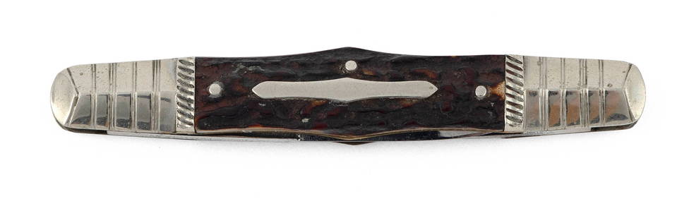
JOSEPH RODGERS & SONS TWO-BLADE POCKETKNIFE Sheffield, 19th Century Length 3.25".Eldred's4.7(419)See Sold PriceFeb 28, 2024
Jerusalem Map for British Soldiers in Palestine - WW2Levy Auction House4.3(11)See Sold PriceFeb 27, 2024
Museum of Horrors - King of Pigs -Emil Zola - 1899Levy Auction House4.3(11)See Sold PriceFeb 27, 2024
Meindert Hobbema or After "The Old Water Mill" Dutch Old Master Oil on Cradled Panel PaintingHess Fine Auctions4.5(210)See Sold PriceMar 02, 2024
VIK MUNIZ (São Paulo, Brazil, 1961), for The Skateroom. "Eigh color spectrum". Screen-printedSetdart Auction House4(23)See Sold PriceMar 04, 2024
DOEL REED (1895-1985) 'NIGHT IN GARCIA' RARE AQUATINTSoulis Auctions4.8(953)See Sold PriceFeb 24, 2024
[WORLD WAR II – OKINAWA]. Okinawa Shima Western Beaches Top...Potter & Potter Auctions4.6(545)See Sold PriceMar 07, 2024
Charles Levier (French,NY,CA,1920-2003) oil paintingBroward Auction Gallery4.7(292)See Sold PriceMay 05, 2024
Carey, pub. 1796 - Map of GeorgiaTrillium Antique Prints & Rare Books4.5(32)See Sold PriceFeb 24, 2024
Carey, pub. 1796 - Map of The State of South CarolinaTrillium Antique Prints & Rare Books4.5(32)See Sold PriceFeb 24, 2024
Carey, pub. 1796 - Map of KentuckyTrillium Antique Prints & Rare Books4.5(32)See Sold PriceFeb 24, 2024
Carey, pub. 1796 - Map of the Tennassee State formerly part of North Carolina (Tennessee)Trillium Antique Prints & Rare Books4.5(32)See Sold PriceFeb 24, 2024
De Jode, Rare, pub. 1593 - Map of Africa (Africae Vera Forma, et Situs)Trillium Antique Prints & Rare Books4.5(32)See Sold PriceFeb 24, 2024
AMERICAN SEASCAPE PAINTING BY ROSS EMBROSE MOFFETTAntique Arena Inc.4.5(878)See Sold PriceMar 02, 2024


![[WORLD WAR II – OKINAWA]. Okinawa Shima Western Beaches Top... (1 of 1)](https://p1.liveauctioneers.com/928/318880/171361141_1_x.jpg?height=282&quality=70&version=1707501302)