SoldA Map of Part of the N: W: Territory of the...[Old Northwest]. A MAP OF PART OF THE N: W: TERRITORY OF THE UNITED STATES: compiled from Actual Surveys, and the best Information, by Samuel Lewis 1796. [Ca. 1802 or 1808. The addition of the map numSee Sold Price
SoldAN ANTIQUE MAP, "Map of Texas," LATE 19TH/EARLY 20THAN ANTIQUE MAP, "Map of Texas," LATE 19TH/EARLY 20TH CENTURY, colored ink on paper, showing railroad stations and indian territories, with detail of "The Pan Handle or N.W. Part of Texas." 9" x 11" NoSee Sold Price
1785 Plat Map "The Seven Ranges of Townships"1785 Engraved Map entitled "Plat of the Seven Ranges of Townships being Part of the Territory of the United States N. W. of the river Ohio which by a late act of Congress are directed to be sold.", enSee Sold Price
SoldEarly plat map of Ohio 1814Heading: Author: Carey, Mathew Title: Plat of the Seven Ranges of Townships. Being part of the Territory of the United States N.W. of the River Ohio which by a late act of Congress are directed to beSee Sold Price
SoldTWO GREAT LAKES REGION MAPS, hand-colored "N. W.TWO GREAT LAKES REGION MAPS, hand-colored "N. W. Territory", Lon. W from Philada., no date evident, and uncolored "Copy of a Map attached to Gov. Colden's History of the Five Indian Nations", London,See Sold Price
SoldScott's US Gazetteer S.W. & N.W. Territory MapsDESCRIPTION: Southwest and Northwest Territory maps from Joseph Scott's The United States Gazetteer circa 1795. Includes: 1) N.W. Territory including Louisiana, Otogamies, Chippewa, Mascoutens, & CanaSee Sold Price
Sold1768 Thomas Jefferys Map NW Parts of Hudson Bay1768 Thomas Jefferys engraved folding map titled The Discoveries Made of the North West Parts of Hudson Bay by Capt. Smith in 1746 & 1747. Originally included in the book THE GREAT PROBABILITY OFSee Sold Price
1858 Map of Brazil, Argentina and UruguayTitle: 1858 Map of Brazil, Argentina and Uruguay Medium: Ink on Paper Dimensions: 14"X18" Map of NW part of South America dated 1858. Map captures Brazil, Argentina, Uruguay and Paraguay. Engraved bySee Sold Price
Chart shewing part of the coast of N.W America,Title/Content of Map: Chart shewing part of the coast of N.W America, Date Printed: 1872 Cartographer: Joseph Baker Size: 27.75X21.5 with the tracks of His Majesty’s sloop Discovery aSee Sold Price
SoldRare map of Alaska Gold Rush 1897Heading: (Alaska) Author: Langrehr, Henry C. Title: Alaska and N.W. Territory Gold Fields from San Francisco Place Published: San Francisco Publisher:H.S. Crocker Co. Date Published: 1897See Sold Price
SoldLAKE MICHIGAN Wisconsin / NW Territory. Indian tribes &Reserve Reduced! TITLE/CONTENT OF MAP: 'NORTH AMERICA, SHEET V., The North West and Michigan Territories' The map was originally engraved in 1833 (this date is printed on the map) and it depicts the aSee Sold Price
Scarce map NW corner of America, 1875Original full hand color map of Washington, Oregon and Idaho. One of the few maps to spell out “Territory of Washington” and “Territory of Idaho” on the map. Scarce map of these states showingSee Sold Price
SoldVancouver: Antique Chart of Northwest Coast of AmericaTitle/Content of Map: A Chart Shewing Part of the Coast of N.W. America, with the Tracks of His Majesty's Sloop Discovery and Armed Tender Chatham . . . [Columbia River to Northern California] Date PrSee Sold Price
Scarce map of NW corner of America, 1875Beautiful map of Washington, Oregon and Idaho with full original hand coloring from one of the last atlases to feature hand coloring. One of the few maps to spell out “Territory of Washington” andSee Sold Price
SoldRare Rufus Sage map of the WestTitle: Map of Oregon, California, New Mexico, N.W. Texas & the Proposed Territory of Ne-Bras-Ka (Nebraska)... Author: Sage, Rufus B. Description: Lithographed map. 45x59.5 cm. (17½x23¼").Rare map ofSee Sold Price
SoldRufus Sage map of the West 1846Heading: Author: Sage, Rufus B. Title: Map of Oregon, California, New Mexico, N.W. Texas & the Proposed Territory of Ne-Bras-Ka... Place Published: New York Publisher:F. Michellins' Lith. Date PSee Sold Price
SoldAN 1855 NEW MAP OF THE UNITED STATES BY LIPPENCOTTHand colored, detailed map; includes part of Canada and Cuba, inset of the Pacific NW. Professionally matted in archival materials, 24.75 x 29.75 inch sight size.See Sold Price
SoldAN ANTIQUE MAP, "Texas and Indian Territory," W. & A.AN ANTIQUE MAP, "Texas and Indian Territory," W. & A. K. JOHNSTON, CIRCA 1878, color print on paper, printed with the benday process, with map, "Western Part of Texas," printed for "Encyclopedia BritaSee Sold Price
Sold1855 N. Amer. w/large w. territories in western U. S.A fascinating version of the United States is frozen in time here when western American territorial boundaries were changing yearly. This map was produced in several editions with the imprint of 1850,See Sold Price
SoldCaptain James Cook.- A collection of mapsCaptain James Cook.- A collection of maps,including Views on the West Coast of America, A Chart of Cooks River in the N.W. part of America, a Sketch of Tongataboo Harbour, and 13 others, severSee Sold Price
SoldSpencer (B) Native Tribes of... AustraliaSpencer (Baldwin) Native Tribes of the Northern Territory of Australia, 1914 § Elkin (A. P.) The Australian Aborigines: How to Understand Them, folding map, 1938 § Thomas (N. W.) The Native RaSee Sold Price
SoldLOT OF 8 UNITED STATES MAPSLOT OF 8 UNITED STATES MAPS. 1. 1894-N.EAST TEXAS, N.W. LOUISIANNA. 2. 1895-KANSAS, INDANA TERRITORY, MO.AR. 3. 1856-ST. MARKS RIVER FLORIDA. 4. 1882-COUNTY MAP OF FLORIDA. 5. 1872-MAP OF MIDDLE STATESee Sold Price
Sold19th C. New Rail Road & County Map of N. CarolinaPublished 1878-1883 probably by George F. Cram; depicts cities, towns, rivers and railroads; inset continuation "Western Part of N. Carolina."; 11 1/2"W, 9"H--Private collection, Spartanburg, South CaSee Sold Price
Parts of E. California, S.E. Nevada, N.W. Arizona &Title: Parts of E. California, S.E. Nevada, N.W. Arizona & S.W. Utah Date: 1878-06-30 Cartographer: WHEELER, GEORGE MONTAGUE Publisher: U.S. GEOLOGICAL SURVEY Size: 14.75Height - 8Width Atlas sheet NuSee Sold Price
Michigan Southern and Northern Indiana RR 14th Annual Report-February 28, 1869JM Hobby Supply and Railroad Artifact Auctions4.4(127)See Sold PriceFeb 24, 2024
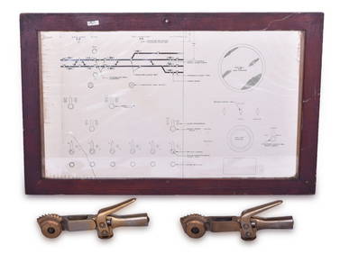
C&NW Railroad Geneva / West Chicago Interlocking Diagram and two Brass Tower Interlocking LeversRail & Road Auctions4.6(165)See Sold PriceMar 08, 2024
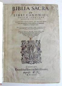
1581 BIBLE in LATIN PRINTED in ENGLAND antique 16th century BIBLIA LATINA RAREJasper524.5(9.9k)See Sold PriceFeb 28, 2024
NORTH WEST AFRICA Maghreb Morocco Tunisia Algeria JOHNSTON 1897 old mapJasper524.5(9.9k)See Sold PriceFeb 28, 2024
MAGHREB. North Africa Morocco Algeria & Tunisia. JOHNSTON 1913 old antique mapJasper524.5(9.9k)See Sold PriceFeb 28, 2024
Northwest Africa. Morocco Sahara Rio do Oro Ain Sefra Gardaia. STANFORD 1904 mapJasper524.5(9.9k)See Sold PriceFeb 28, 2024
AFRICA NW & SOUTH. Maghreb. Cape Colony electoral divisions. JOHNSTON 1906 mapJasper524.5(9.9k)See Sold PriceFeb 28, 2024
Northwest Africa. Morocco Sahara Rio do Oro Ain Sefra Gardaia. STANFORD 1904 mapJasper524.5(9.9k)See Sold PriceFeb 28, 2024
Chevrolet Genuine Parts Logo (1934-1940) 1 oz Gold w/ TEPGolden Air Auctions4.4(265)See Sold PriceFeb 24, 2024
[BATTLE OF BRITAIN]: CURRANT CHRISTOPHER 'BUNNY': (1911-2006)International Autograph Auctions Europe S.L.4.5(52)See Sold PriceMar 14, 2024
Chevrolet Genuine Parts Logo (1934-1940) 1 oz Silver w/ TEPGolden Air Auctions4.4(265)See Sold PriceFeb 29, 2024
Carl Ludwig Thilson Locher (1851 - 1915) Denmark/FranceCutler Bay Auctions4.5(174)See Sold PriceFeb 29, 2024
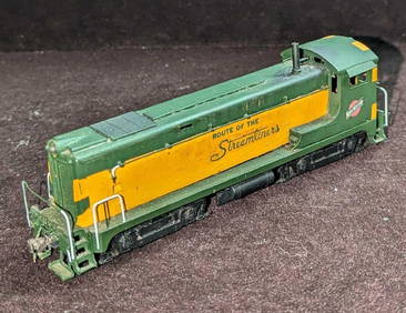
Hallmark Models HO Scale Chicago NW Railway LocomotiveRapid Estate Liquidators and Auction Gallery4.5(1.1k)See Sold PriceMar 01, 2024
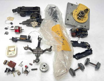
Vintage Kato HO Scale Chicago NW System Locomotive 1524Rapid Estate Liquidators and Auction Gallery4.5(1.1k)See Sold PriceMar 01, 2024
Herman Moll A New Map of Ye North Parts of AmericaWillow Auction House4.5(289)See Sold PriceMar 14, 2024
Vintage Marked Tupperware Freeze N Save Ice Cream Almond W/ Clear Lid ContainerRapid Estate Liquidators and Auction Gallery4.5(1.1k)See Sold PriceMar 03, 2024
Hudson River Map & North American Postcards, 45Auctions at Showplace4.6(740)See Sold PriceFeb 13, 2025


![[BATTLE OF BRITAIN]: CURRANT CHRISTOPHER 'BUNNY': (1911-2006) (1 of 1)](https://p1.liveauctioneers.com/1458/320148/172030839_1_x.jpg?height=282&quality=70&version=1708367366)