SoldScott's US Gazetteer S.W. & N.W. Territory MapsDESCRIPTION: Southwest and Northwest Territory maps from Joseph Scott's The United States Gazetteer circa 1795. Includes: 1) N.W. Territory including Louisiana, Otogamies, Chippewa, Mascoutens, & CanaSee Sold Price
Sold3 Early Southern and TN Maps, inc. Mero District plusFour (4) items total, 3 unframed maps and 1 book excerpt. 1st item: Joseph Scott: THE SOUTHWEST TERRITORY, Scott's Gazetteer, Phila. 1795, showing the Mero district, Nashville, Knoxville, ClarksvilleSee Sold Price
Parts of E. California, S.E. Nevada, N.W. Arizona &Title: Parts of E. California, S.E. Nevada, N.W. Arizona & S.W. Utah Date: 1878-06-30 Cartographer: WHEELER, GEORGE MONTAGUE Publisher: U.S. GEOLOGICAL SURVEY Size: 14.75Height - 8Width Atlas sheet NuSee Sold Price
Sold1795 Joseph T. Scott's Map of Southwest Territoryfrom the United States Gazetteer. site size: H6 1/4" W7 3/8"See Sold Price
Sold1795 Joseph T. Scott's Map of Northwest Territoryfrom the United States Gazetteer. sight size: H6 1/4" W7 3/8"See Sold Price
SoldABERT AND PECK MAP OF THE NEW MEXICO TERRITORY 1848Map of the Territory of New Mexico made by order of Brig. Gen. S.W. Kearny, under instructions from Lieut. W. H. Emory, .S.T.E., by Lieut's J.W. Abert and W.G. Peck, 1846-7, US Govt., Washington, compSee Sold Price
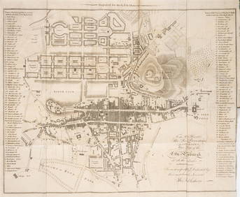
Sold[Maps] Pair of Maps of Southern U.S.Pair of folding maps, late 18th century, both folded (as bound in Morse's American Gazetteer at some point). On laid. Includes: * "A Correct Map of the Georgia Western Territory." Sheet 8.25" x 7.5".See Sold Price
Sold12 U.S. Gazetteer Maps, 1795, 13 itemsThirteen (13) Early American maps, including twelve (12) from THE UNITED STATES GAZETTEER, First Edition, 1795. 1st-12th items: Twelve (12) maps from THE UNITED STATES GAZETTEER, First Edition, by JosSee Sold Price
Sold1799 EDWARD TIFFIN, U.S. NW Territory DocumentAutographs 1799 Edward Tiffin Northwest Territory Document Signed EDWARD TIFFIN (1766-1829). 1st Governor of Ohio (1803-07), Surveyor General Northwest Territory (1815-29); U.S. Senator, Congressman aSee Sold Price
Sold1799 EDWARD TIFFIN, U.S. NW Territory DocumentFederal Period 1799 Edward Tiffin Northwest Territory Document Signed EDWARD TIFFIN (1766-1829). 1st Governor of Ohio (1803-07), Surveyor General Northwest Territory (1815-29); U.S. Senator, CongressmSee Sold Price
Sold1799 EDWARD TIFFIN, U.S. NW Territory DocumentAutographs 1799 Edward Tiffin Northwest Territory Document Signed EDWARD TIFFIN (1766-1829). 1st Governor of Ohio (1803-07), Surveyor General Northwest Territory (1815-29); U.S. Senator, Congressman aSee Sold Price
Sold1799 EDWARD TIFFIN, U.S. NW Territory DocumentAutographs 1799 Edward Tiffin Northwest Territory Document Signed EDWARD TIFFIN (1766-1829). 1st Governor of Ohio (1803-07), Surveyor General Northwest Territory (1815-29); U.S. Senator, Congressman aSee Sold Price
Sold1903 US Dept Interior US, Territories map1903 US Department of the Interior Map of the United States including Territories and Insular Possessions, on rollers, stains, flaking losses along top edge, browning along bottom edge, 60" x 83"See Sold Price
Sold1888 US & Territories mapAlso includes part of the west India islands. Scale of statue miles 40-1in. Dated Dec 31 1888 by the General land office. Overall size 82" wide X 64" high. Some losses. Brittle.See Sold Price
Sold1890's Hand Tinted Northwest Territory MapFeatured in this lot we have a hand tinted Northwest US territory maps originating from the 1890's. The map details the Northwest territories including Wyoming, Idaho, and Montana. The map shows mountSee Sold Price
SoldLike New Scott U.S. Trust Territories Album to 1997Very, clean never used loose leaf album and pages for U.S. trust territories with slipcase. Includes pages for Marshall Islands and Micronesia. Fresh album. Retail $200See Sold Price
Sold1873 Skeleton Map US Territory West of Missisippi"Skeleton Map Of the Territory of the United States west of the Mississippi River Exhibiting the Relations Existing Between Lines And Areas Of Explorations & Surveys Conducted under the auspices of thSee Sold Price
Sold(2) 1893 MAP U.S. INDIAN TERRITORIES & WATER MAP(lot of 2) Framed "Map of Aboriginal America Showing the Distribution and Territorial Limits of The Indian Nations, In The New World", taken from the "Columbian Atlas of the World We Live In", Hunt &See Sold Price
Sold1953 U.S. Oregon Territory ,Texas Annex MapSecond Side of 2 Parts, Overall Good Condition Interior of Map, Some Tearing on Edges Outside of Map Content, 44" x 64", Both Maps Have Been Rolled Up For Many YearsSee Sold Price
MAP, Arizona Territory, U.S. Dept. of InteriorArizona Territory. U.S. Department of Interior, Dept. of the Interior Pacific Wagon Roads. Map No. 1 of the El Paso & Fort Yuma Wagon Road..., from Wagon Roads... A Report Upon the Several Roads ConstSee Sold Price
King Map of U.S. Territories, 1898King, Harry. ...United States and Territories Showing the Extent of Public Surveys. Lithographed map. Government Land Office, 1898. 58 ½" x 81" sheet. Inset shows only Alaska. Dates of acquisitionsSee Sold Price
Antique US Map of Territories & Pacific States, 1865Domestic: Free Shipping Item: Old Antique Map of the Western United States Title: Territories & Pacific States to Accompany "Across the Continent" by Samuel Bowles Engraver: J.H. Goldtwhait Printer: GSee Sold Price
SoldMap of territory of US 1858 ordered by Jefferson DavisWarren (Lt,. Topographical Engineers) G.K. Map of the territory of the United States from the Mississippi River to the Pacific Ocean ordered by the Honorable Jefferson Davis, Secretary of War.. ExplorSee Sold Price
SoldU.S. MAP WASHINGTON TERRITORY, ANSON HENRY, 1863"Map of Public Surveys, Washington Territory to accompany Report of Surv: Genl: 1863, Anson G. Henry, Surveyor General, Lith of J. Bien 24 Vesey St, NY", showing positions of Mt. Baker, Gold Mines, OlSee Sold Price
Central Railroad of New Jersey Map of Sandy Hook Route-ca. 1903JM Hobby Supply and Railroad Artifact Auctions4.4(127)See Sold PriceFeb 24, 2024
Vintage mid 20C American oil painting signedBroward Auction Gallery4.7(292)See Sold PriceMar 17, 2024
FLYING A TOURING SERVICE U.S. ROAD MAPS TIN WALL DISPLAY.Dan Morphy Auctions4.2(1.3k)See Sold PriceFeb 25, 2024
1885 CIVIL WAR 1ed Famous Memoirs US Grant Sheridan Sherman 6v RARE LOT MapsSchilb Antiquarian Rare Books4.8(428)See Sold PriceMar 10, 2024
1963 J.F.K. for US PRESIDENT RE-ELECTION MATERIALJohn McInnis Auctioneers,LLC4.5(505)See Sold PriceFeb 25, 2024
Collection of Allied Military Silk Printed Maps, WWII Era and LaterMaterial Culture4.6(778)See Sold PriceFeb 29, 2024
Scott Rohlfs (AL,CA,20/21C) acrylic paintingBroward Auction Gallery4.7(292)See Sold PriceMay 05, 2024
[VIETNAM]. A group of approx. 120 photographs assembled by African American soldier Vernon CliftonFreeman's | Hindman4.4(1.6k)See Sold PriceFeb 27, 2024
Karl Bodmer - A Young Mandan Indian. 24Trillium Antique Prints & Rare Books4.5(32)See Sold PriceFeb 24, 2024
Karl Bodmer - Scalp Dance of the Minatarres. 27Trillium Antique Prints & Rare Books4.5(32)See Sold PriceFeb 24, 2024
GEORGE ANDREW CORLEY (DATES UNKNOWN) U.S. TEAM SKI TRYOUTS / MT. HOOD OREGON. 1939.Swann Auction Galleries4.4(70)See Sold PriceFeb 29, 2024
Scotland.- Sir Walter Scott's Edinburgh.- The Post-Office annual directory, from Whitsunday 1808, toForum Auctions4.3(53)See Sold PriceFeb 29, 2024
Herman Moll A New Map of Ye North Parts of AmericaWillow Auction House4.5(289)See Sold PriceMar 14, 2024


![[Maps] Pair of Maps of Southern U.S. (1 of 3)](https://p1.liveauctioneers.com/3532/146911/74242637_1_x.jpg?height=282&quality=70&version=1564368564)


![[VIETNAM]. A group of approx. 120 photographs assembled by African American soldier Vernon Clifton (1 of 6)](https://p1.liveauctioneers.com/197/319238/171468143_1_x.jpg?height=282&quality=70&version=1707520367)