1785 Plat Map "The Seven Ranges of Townships"1785 Engraved Map entitled "Plat of the Seven Ranges of Townships being Part of the Territory of the United States N. W. of the river Ohio which by a late act of Congress are directed to be sold.", enSee Sold Price
SoldEarly plat map of Ohio 1814Heading: Author: Carey, Mathew Title: Plat of the Seven Ranges of Townships. Being part of the Territory of the United States N.W. of the River Ohio which by a late act of Congress are directed to beSee Sold Price
Sold1900 Plat Map of a Section of Cherokee Nation Land --Title/Content of Map: 1900 Plat Map of a Section of Cherokee Nation Land -- Cherokee Nation Township 22 North, Range 21 East Date: 1900 c. Muskogee, Ind. Terr. Cartographer: Indian Territory Map Co. SSee Sold Price
1900 Plat Map of a Section of Cherokee Nation Land --Title/Content of Map: 1900 Plat Map of a Section of Cherokee Nation Land -- Cherokee Nation Township 22 North, Range 21 East Date Printed: 1900 c. Muskogee, Ind. Terr. Cartographer: Indian Territory MSee Sold Price
Sold1900 Plat Map of a Section of Cherokee Nation Land --Reserve Reduced! Map Title/Content: 1900 Plat Map of a Section of Cherokee Nation Land -- Cherokee Nation Township 22 North, Range 21 East Cartographer: Indian Territory Map Co. Year / Place: 1900 c.See Sold Price
1900 Plat Map of a Section of Cherokee Nation LandTitle/Content of Map: 1900 Plat Map of a Section of Cherokee Nation Land -- Cherokee Nation Township 22 North, Range 21 East Date Printed: 1900 c. Muskogee, Ind. Terr. Cartographer: Indian Territory MSee Sold Price
1900 Plat Map of a Section of Cherokee Nation Land --Title/Content of Map: 1900 Plat Map of a Section of Cherokee Nation Land -- Cherokee Nation Township 22 North, Range 21 East Date: 1900 c. Muskogee, Ind. Terr. Cartographer: Indian Territory Map Co. SSee Sold Price
Very scarce and important map of the Seven Ranges of Ohio, 1814Very few printed pieces are of more importance in the history of Ohio than this survey of a part of the future state. Considered by some as the map that began the opening to the American West, and whiSee Sold Price
SoldLOT OF THREE MISSOURI MAPSMISSOURI MAPS INCLUDE TWO ST. LOUIS COUNTY PLAT MAP, 1893, AND TOWNSHIP 46 & 48 OF 5TH PRINCIPAL MERIDIAN. APPROXIMATE SIZE 16" X 14".See Sold Price
SoldLot of Paper including VT MapsEarly VT township Map, Seven wonders of the world lithographs, Van Gogh lithographs, Amos Doolittle folio, repro early VT Conventions, Rutland RR cards and stencilsSee Sold Price
Untitled. [Surveys of Public Lands in Illinois andTitle: Untitled. [Surveys of Public Lands in Illinois and Missouri Date: 1860 Cartographer: ANONYMOUS Publisher: American State Papers Size: Height - Width Provenance: Seven plat maps (one large foldiSee Sold Price
SoldLot of 3 Maps - County and PlatLot of 3 Maps. 1 - Burlington WI Plat Map. 2 - Norway WI Plat Map. 3 - Walworth County Township Map. Various. See photos for details. Shipping: After your invoice is paid, our Shipping Department willSee Sold Price
Map of Township 18, Range 3. | Map of Township 18,Title: Map of Township 18, Range 3. | Map of Township 18, Range 4 Publication Date: 1834 Cartographer: PAGUENAUD, E. Publisher: American State Papers Size: 4.75Height - 4.75Width ... For the explanatiSee Sold Price
SoldAntique Folio Atlas STANDARD ATLAS OF WAUKESHA COUNTYAntique Folio Atlas STANDARD ATLAS OF WAUKESHA COUNTY WISCONSIN 1914 Elephant Folio Color Maps Plat Maps Patron Business Directory History Towns Townships Bellevue Big Bend Brookfield Delafield EagleSee Sold Price
Soldoriginal 1800's Group of 2 LaSalle County Illinois PlatMid 1800's Plat map with original drawings and names, Township 35 with Indian Creek, appears to be a very very early map of Wedron I.See Sold Price
SoldKitchin, Thomas 1785 Map of Germany & Netherlands"Germany with the Seven United Provinces" Copper Engraved Map Published 1783-85, London for "A New Geographical, Historical and Commercial Grammar..." by William Guthrie. Drawn and Engraved by ThomasSee Sold Price
Lake Superior and Mississippi River RR 1869 Seven Percent Bonds Book/Report-1869JM Hobby Supply and Railroad Artifact Auctions4.4(127)See Sold PriceFeb 24, 2024
Crams Township and Railroad Map of New York-1890JM Hobby Supply and Railroad Artifact Auctions4.4(127)See Sold PriceFeb 24, 2024
Crams Township and Railroad Map of Pennsylvania-1898JM Hobby Supply and Railroad Artifact Auctions4.4(127)See Sold PriceFeb 24, 2024
Rand McNally County/Township/Railroad Map of Kansas-1911JM Hobby Supply and Railroad Artifact Auctions4.4(127)See Sold PriceFeb 24, 2024
Rand McNally Township County and Railroad Map of Illinois-1879JM Hobby Supply and Railroad Artifact Auctions4.4(127)See Sold PriceFeb 24, 2024
Rand McNally Township County and Railroad Map of Indiana-1880JM Hobby Supply and Railroad Artifact Auctions4.4(127)See Sold PriceFeb 24, 2024
1853 Colton's Railroad & Township Map of Massachusetts, Rhode Island, and ConnecticutRail & Road Auctions4.6(165)See Sold PriceMar 07, 2024
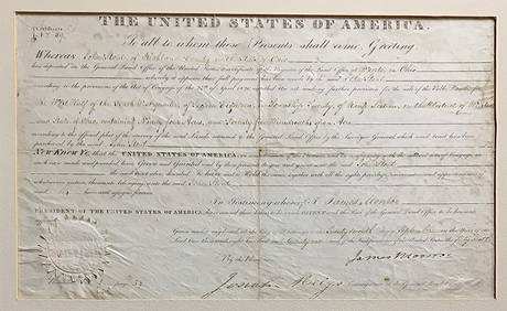
[JUNEAU, Solomon (1793-1856), association]. Land Deed for J...Potter & Potter Auctions4.6(545)See Sold PriceMar 07, 2024
WEST AFRICA Explorers' routes Senegal Ashanti. Mountains of Kong. SDUK 1857 mapJasper524.5(9.9k)See Sold PriceFeb 28, 2024
AFRICA. Map pre-dating much exploration. Mountains of Kong. SDUK 1851 oldJasper524.5(9.9k)See Sold PriceFeb 28, 2024
Buffon, Vaugody & Bell 1785 America - Map of the New ContinentAlbion Auctions4.7(341)See Sold PriceMar 01, 2024
Buffon, Vaugody & Bell 1785 Map of the Old Continent. Africa, AsiaAlbion Auctions4.7(341)See Sold PriceMar 01, 2024
Set of 4 Maps - Netherlands - Seven United Provinces - Germany - Sweden, Denmark, Norway, FinlandProverde Auctions4.3(3)See Sold PriceFeb 28, 2024
Map of United States of North America, 1785Antiques Online Auctions4.6(415)See Sold PriceMar 14, 2024


![[JUNEAU, Solomon (1793-1856), association]. Land Deed for J... (1 of 2)](https://p1.liveauctioneers.com/928/318880/171361009_1_x.jpg?height=282&quality=70&version=1707501302)