ATLAS of ANTIENT GEOGRAPHY by SAMUEL BUTLER 1843John McInnis Auctioneers,LLC4.5(505)See Sold PriceFeb 24, 2024
18TH C. ANTIQUE MAP: FRENCH & INDIAN WAR, FRAMEDThomaston Place Auction Galleries4.4(393)See Sold PriceFeb 24, 2024
Rand McNally Railroad Map Cabinet w/ 21 Railroad MapsRail & Road Auctions4.6(165)See Sold PriceMar 08, 2024
Keith Haring - Ink on New York Map, Best Buddies, Inscribed, Signed, and DatedSapphire Auction Gallery4.1(67)See Sold PriceMar 02, 2024
LATE 17TH C. FRENCH MAP OF THE NEW WORLD BY ALEXIS-HUBERT JAILLOT (1632-1712)Thomaston Place Auction Galleries4.4(393)See Sold PriceFeb 24, 2024
Central Railroad of New Jersey Map of Sandy Hook Route-ca. 1903JM Hobby Supply and Railroad Artifact Auctions4.4(127)See Sold PriceFeb 24, 2024
Lot of Six Mixed Atlas Box Cars-HO Scale-New in BoxJM Hobby Supply and Railroad Artifact Auctions4.4(127)See Sold PriceFeb 25, 2024
Rand McNally/Santa Fe Railroad Map of Iowa-1912JM Hobby Supply and Railroad Artifact Auctions4.4(127)See Sold PriceFeb 24, 2024
NICOLAES VISSCHER (NETHERLANDS, 1618-1709) MAP OF THE NEW WORLDThomaston Place Auction Galleries4.4(393)See Sold PriceFeb 24, 2024
17TH C. WORLD MAP BY NICOLAES VISSCHER (NETHERLANDS, 1618-1709)Thomaston Place Auction Galleries4.4(393)See Sold PriceFeb 24, 2024
Lot of Six Mixed Atlas Cabooses-HO Scale-New in BoxJM Hobby Supply and Railroad Artifact Auctions4.4(127)See Sold PriceFeb 25, 2024
SoldA Large Group of Cincinnati Land Survey MapsCourthouse survey maps of downtown Cincinnati Ohio and its wards, lot includes Cincinnati embracing its wards Part X, V, III, VI, IV, I and II; largest 42 x 22 inches. Overall good condition.See Sold Price
SoldA Large Group of Cincinnati Survey MapsCourthouse survey maps of Cincinnati Ohio and its neighborhoods, lot includes Storrs, Riverside, Miamitown Elizabeth Town, Spencer, Sycamore, Glendale, and Harrison; largest 34 x 22 inches (frame). OvSee Sold Price
SoldA Large Group of Cincinnati Survey MapsCourthouse survey maps of Cincinnati Ohio and its neighborhoods, lot includes Columbia Tusculum, Symmes, Mount Washington, Fairmount, Anderson and Crosby. Overall good condition.See Sold Price
SoldA Large Group of Cincinnati Survey MapsCourthouse survey maps of Cincinnati Ohio and its neighborhoods, lot includes Mt. Auburn, Walnut Hills, Corryville, Clifton, Camp Washington and Avondale; largest 34 x 22 inches (frame) Overall good cSee Sold Price
Sold(NEW YORK – DUTCHESS COUNTY.) Large group of(NEW YORK – DUTCHESS COUNTY.) Large group of manuscript maps and surveys of properties in and around Fishkill and Wappingers Falls. Approximately 40 mostly manuscript land surveys on various wovSee Sold Price
SoldA Large Grouping of Cincinnati Survey MapsCourthouse survey maps of Cincinnati Ohio and its neighborhoods, lot includes Miami White Water, Colerain, Green Township, Cumminsville, Lockland Reading, College Hill, Springfield, Mill Creek; largesSee Sold Price
SoldLarge New Jersey Archive - 18th and 19th CenturyLarge grouping of New Jersey related land documents, manuscript survey maps, receipts, letters, and miscellaneous documents dating from the early 18th century to the mid 19th century. Family names incSee Sold Price
Sold2 LG & 4 SMALLER SURVEYORS MAPS OF CALIFORNIA4 1972 GEOLOGICAL SURVEY MAPS OF CALIFORNIA COUNTIES - OILER PEAK - BRECKENRIDGE MOUNTAIN - PIUTE PEAK AND LORAINE AND 2 LARGE BUREAU OF LAND MANAGEMENT MAPS OF CALIFORNIA - DATED 1989 - BUYERS RESPONSee Sold Price
SoldLg Group Documents 1686-1762 Land Treaties 2 MapsLg Group Documents 1686-1762 Land Treaties 2 Maps, Large lot of historic documents primarily form the 18th century relating to the Easton Pennsylvania area, treaties with the Delaware Indians, and lanSee Sold Price
SoldOVER 60 WW2 ORDNANCE SURVEY, BRITISH ARMY AND RAF MAPSA large group of over 60 assorted WW2-era Ordnance Survey, British Army and Royal Air Force maps of the United Kingdom and parts of Continental Europe. Most of the maps cover parts of the UK in detailSee Sold Price
SoldBENG A large mixed group of maps of the U.K.BENG A large mixed group of maps of the U.K.including editions of Bartholomew's Half-Inch to Mile Map of England & Wales, with editions of Ordnance Survey New Popular Edition One-Inch MapsSee Sold Price
Sold(CARTOGRAPHY) A GROUP OF SIX CARTOGRAPHIC BIBLIOGRA(CARTOGRAPHY) A GROUP OF SIX CARTOGRAPHIC BIBLIOGRAPHIES Maps and Surveys of the Pueblo Lands of Los Angeles; Antique Map Prices, 1987; The World Encompassed; Cities on Stone, Neneteenth Century LithoSee Sold Price
SoldMaps of Various United States of AmericaLarge group of 19th and 20th century maps of parts of the United States. F. H. Gerdes (1809-1884) "U. S. Coast Survey Preliminary Chart of Ship Island Shoal Louisiana" U.S. Coast Survey, Washington DCSee Sold Price
SoldBartholomew, John 1922 Group of 3 Large Maps of ChinaLarge Lithograph Map Published 1922 by The Times, London for "The Times Survey Atlas of the World" Maps by John George Bartholomew of the Edinburgh Geographical Institute. Centre fold as issued. PaperSee Sold Price
Bartholomew, John 1922 Group of 3 Large Maps of ChinaLarge Lithograph Map Published 1922 by The Times, London for "The Times Survey Atlas of the World" Maps by John George Bartholomew of the Edinburgh Geographical Institute. Centre fold as issued. PaperSee Sold Price
SoldThirty-Two Blueprints and Plans for Logansport Yard Pittsburgh, Cincinnati, Chicago & St. LouisA large group of thirty-two blueprints and drafting plans for Logansport Yard dated 1916, 1917, 1918, and 1963. The items dated 1916 include 4 Station Map Track plans, 1 Yard Map, and 5 Proposed AdditSee Sold Price
SoldLarge Land Office map of U.S. 1868Heading: (United States) Author: Gorlinski, Joseph Title: Map of the United States and Territories, Showing the extent of Public Surveys and other details, Constructed From the Plats and official sourSee Sold Price
SoldLarge colored map of Shasta Co. CA 1912Heading: (California - Shasta County) Author: Wiegel, C. R. Title: Map of the County of Shasta California. Compiled from U.S. geological and U.S. land surveys, official and private surveys, etc. by C.See Sold Price
1736 LARGE MAP OF SILESIA POLAND SCHWIDNICENSIS antique 25 x 4 3/4"Principatus Silesiae SCHWIDNICENSIS by HOMANN HEIRS Nuremberg, 1736 The land survey was done by J. W. Wieland, and corrected by M. v. Schubarth. With a large very attractive cartouche in the upper lefSee Sold Price
1739 LARGE MAP OF SILESIA POLAND GLOGOVIENSIS antique 25 x 4 3/4"Principatus Silesiae GLOGOVIENSIS by HOMANN HEIRS Nuremberg, 1739 The land survey was done by J. W. Wieland, and corrected by M. v. Schubarth. With a large very attractive cartouche in the upper leftSee Sold Price
Map of Martinez California Tide LandsDescription:Large folding map. Approximately 23¾x31. 20th century reprinting of 1851 survey map with printed additions to 1895 and later additions colored by hand showing the tide lands and town of MSee Sold Price
SoldLarge Land Office map of U.S. 1868Heading: Author: Gorlinski, Joseph Title: Map of the United States and Territories, Showing the extent of Public Surveys and other details, Constructed From the Plats and official sources of the GeneSee Sold Price
1858 Map of Public Surveys in California...This remarkable large format map of California reports the extent of the Land Office Survey through 1858, just eight years after it had become the 31st state in the Union. The map is highly detailed wSee Sold Price
Large G.L.O. U.S. Map Concentrating On WesternHawes, J. H. Map of the Public Land States And Territories Constructed from the Public Surveys...in The General Land Office. Lithographed map with original hand color. War Department (D. McClennan), 1See Sold Price
Rand McNally & Co's New Ideal State and County Survey and Atlas 1911North American Artifact Auctions4.7(198)See Sold PriceApr 20, 2024
[MAP]. NICHOLLS, Sutton (1668-1729). An Epitome of Sr. Will...Potter & Potter Auctions4.6(545)See Sold PriceMar 07, 2024
[LITHOGRAPHY]. A Large Group of Over 130 Items Related to B...Potter & Potter Auctions4.6(545)See Sold PriceMar 07, 2024
[CIVIL WAR]. A group of 9 illustrated covers featuring political cartoons depicting African AmericanFreeman's | Hindman4.4(1.6k)See Sold PriceFeb 27, 2024
D'Entrecasteaux - Australia: Chart of Van Diemen's Land (New Holland). 3Trillium Antique Prints & Rare Books4.5(32)See Sold PriceFeb 24, 2024
1736 LARGE MAP OF SILESIA POLAND OPPAVIENSIS antique 25 by 34 3/4"Jasper524.5(9.9k)See Sold PriceFeb 27, 2024
1736 LARGE MAP OF SILESIA POLAND KARNOVIENSIS antique 25 x 4 3/4" Duchy of KrnovJasper524.5(9.9k)See Sold PriceFeb 27, 2024
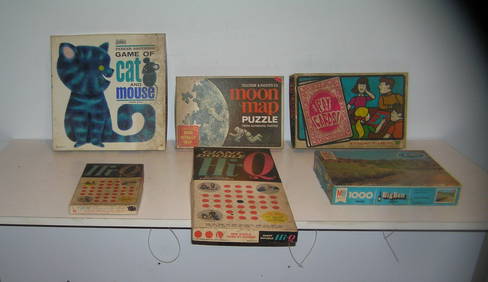
Large group of vintage games and puzzlesBaker's Antiques and Auctions3.2(471)See Sold PriceFeb 24, 2024
Mexico, Central America and West Indies Physical PoliticalJasper524.5(9.9k)See Sold PriceFeb 27, 2024
La Basse-Guinée… Loango, Congo, AngoIa & Benguela Southern Africa BONNE 1788 mapJasper524.5(9.9k)See Sold PriceFeb 28, 2024
Alfred Salzman, Etc. JNF Tin Tzedakah Boxes, 3Auctions at Showplace4.6(740)See Sold PriceApr 07, 2024
Large group of vintage games and puzzlesBaker's Antiques and Auctions3.2(471)See Sold PriceMar 03, 2024


![[MAP]. NICHOLLS, Sutton (1668-1729). An Epitome of Sr. Will... (1 of 1)](https://p1.liveauctioneers.com/928/318880/171361281_1_x.jpg?height=282&quality=70&version=1707501302)
![[LITHOGRAPHY]. A Large Group of Over 130 Items Related to B... (1 of 1)](https://p1.liveauctioneers.com/928/318880/171361547_1_x.jpg?height=282&quality=70&version=1707501302)
![[CIVIL WAR]. A group of 9 illustrated covers featuring political cartoons depicting African American (1 of 2)](https://p1.liveauctioneers.com/197/319238/171468108_1_x.jpg?height=282&quality=70&version=1707520367)