ATLAS of ANTIENT GEOGRAPHY by SAMUEL BUTLER 1843John McInnis Auctioneers,LLC4.6(502)See Sold PriceFeb 24, 2024
18TH C. ANTIQUE MAP: FRENCH & INDIAN WAR, FRAMEDThomaston Place Auction Galleries4.4(386)See Sold PriceFeb 24, 2024
Rand McNally Railroad Map Cabinet w/ 21 Railroad MapsRail & Road Auctions4.6(165)See Sold PriceMar 08, 2024
Keith Haring - Ink on New York Map, Best Buddies, Inscribed, Signed, and DatedSapphire Auction Gallery4(67)See Sold PriceMar 02, 2024
LATE 17TH C. FRENCH MAP OF THE NEW WORLD BY ALEXIS-HUBERT JAILLOT (1632-1712)Thomaston Place Auction Galleries4.4(386)See Sold PriceFeb 24, 2024
Central Railroad of New Jersey Map of Sandy Hook Route-ca. 1903JM Hobby Supply and Railroad Artifact Auctions4.4(126)See Sold PriceFeb 24, 2024
Lot of Six Mixed Atlas Box Cars-HO Scale-New in BoxJM Hobby Supply and Railroad Artifact Auctions4.4(126)See Sold PriceFeb 25, 2024
Rand McNally/Santa Fe Railroad Map of Iowa-1912JM Hobby Supply and Railroad Artifact Auctions4.4(126)See Sold PriceFeb 24, 2024
NICOLAES VISSCHER (NETHERLANDS, 1618-1709) MAP OF THE NEW WORLDThomaston Place Auction Galleries4.4(386)See Sold PriceFeb 24, 2024
17TH C. WORLD MAP BY NICOLAES VISSCHER (NETHERLANDS, 1618-1709)Thomaston Place Auction Galleries4.4(386)See Sold PriceFeb 24, 2024
Lot of Six Mixed Atlas Cabooses-HO Scale-New in BoxJM Hobby Supply and Railroad Artifact Auctions4.4(126)See Sold PriceFeb 25, 2024
SoldA 1755 MAP OF RUSSIAA 1755 MAP OF RUSSIA. Comprising an 18th century map of Russia entitled "Partie Septentrionale De La Russie Europeenne" by French cartographer Robert de Vaugondy. The map displays colored borderlinesSee Sold Price
Map of Tartary Russia, Bonne, 1780, Copper etchingTitle/Content of Map: Map of Tartary Russia, Bonne, 1780, Copper etching Date: 1780 Cartographer: Rigobert Bonne (1727-1755), André Material/Medium: Copper etching Size: Leaf Dimension: 31,5x46 cm (1See Sold Price
Map of Tartary Russia, Bonne, 1780, Copper etchingVery beautiful map by Rigobert Bonne featuring Tartary Russia. Author: Rigobert Bonne (1727-1755), André Date: 1780 circa Technique: etching on copper Leaf Dimension: 31,5x46 cm (12.4x18.1 inches) EnSee Sold Price
SoldRussia - history. GORDON (A) The History of Peter theRussia - history. GORDON (A) The History of Peter the Great, in 2 vols., Aberdeen 1755, 8vo, 3 portraits, folding map, contemporary calf; [WEBER (F C)] The Present State of Russia, 2 vols., London 172See Sold Price
SoldPrevost: Yenisei River / Kungur Ice Cave, RussiaTitle/Content of Map: Prevost: Yenisei River / Kungur Ice Cave, Russia Date Printed: 1755, Paris Cartographer: Bellin / Prevost d'Exile Size: (1) 6" x 8 1/2"; (2) 6 5/8" x 4 1/2" Bellin's superbly detSee Sold Price
Sold1755 Map of the British and French settlements in NorthArtist: Hinton, John, London Title: A Map of the British and French settlements in North America. A MAP OF THE BRITISH AND FRENCH SETTLEMENTS IN NORTH AMERICA. Univ. Mag. J. Hinton Newgate Street. ConSee Sold Price
SoldEarly 18th C Handcolored Map Russia MoscoviaNicely handcolored map of Russia Sive Moscovia, text on verso. Fine, measures 8.5 x 6.5". Reserve: $50.00 Shipping: Domestic: Flat-rate of $5.00 to anywhere within the contiguous U.S. International: FSee Sold Price
SoldMAP - Russia in Europe. De FerRussia in Europe. Nicholas de Fer, Estats du Grand Duc de Moscovie Suivant les Derniere Relations, 1705 (circa). Hand Color. Handsome, smaller map covering European Russia with part of Finland, showinSee Sold Price
SoldLochhead (Pub) 1811 Rare Map. Russia in Europe"The Southern Part of Russia in Europe with Russian and Little Tartary" Copper Engraved Map Published 1811 by William Lochhead, Berwick for "Modern Geography: And a Compendious General Gazetteer" RareSee Sold Price
Sold1755 MAP OF US EAST COAST BY ROBERT DE VAUGONDYDe L'Amerique Septentrionale. By Robert de Vaugondy, Didier, 1723-1786 ; and Robert de Vaugondy, Gilles, 1688-1766, The map is dated 1755, but was published in Vaugondy Atlas Universal Paris in 1757.See Sold Price
Big 1860 Ink Hand Drawn Map Russia Signed C. E. BeckeOld Antique 1860 Hand Drawn Pen & Ink Map of Russia by C.E. Beckel. Notice detailed markings on mountain regions and rivers. Appears to be Northern Russia near the Arctic circle. Name of person drawinSee Sold Price
SoldGuthrie, William 1790 Antique Map. Russia or MuscovyCopper Engraved Map Published 1790, London for "A New Geographical, Historical and Commercial Grammar..." by William Guthrie. The maps are by John Senex, Thomas Kitchin and others. Folds as issued. EaSee Sold Price
SoldPhilip, George 1856 LG Hand Col Map. Russia in EuropeLarge Folio Lithograph Map Published Published 1856 by George Philip, Liverpool for "Philips' Commercial Atlas of the World" Paper Size: 26 x 21 inch (66 x 53cm) Light horizontal bend in centre. NeatlSee Sold Price
SoldMAP, Russia in Europe, JanvierRussia in Europe. Janvier/Lattre, Russie d'Europe avec la Partie la Plus Peuplee de Celle d'Asie..., 1760 (circa). Hand Color. This remarkably detailed map covers the region from the Gulf of Finland aSee Sold Price
SoldRare 1839 Map Russia by Alan BellRUSSIA IN EUROPE ALLAN BELL - RUSSIA This map is in very good condition, folded as published, mapmaker Allan Bell, published in London, 1839, vibrant original hand coloring, borders a little foxed inSee Sold Price
SoldTallis, John (Pub) 1852 Map. Russia In AsiaSteel Engraved Map with Original Outline Hand Color Published 1852-56 by John Tallis, London for "The Universal Pronouncing Dictionary" by Thomas Wright. Drawn & Engraved by John Rapkin. Centre fold aSee Sold Price
SoldTallis, John (Pub) 1852 Map. Russia in EuropeSteel Engraved Map with Original Outline Hand Color Published 1852-56 by John Tallis, London for "The Universal Pronouncing Dictionary" by Thomas Wright. Drawn & Engraved by John Rapkin. Centre fold aSee Sold Price
SoldBarclay, James C1835 Hand Col Map. Russia in EuropeOutline Hand Colored Copper Engraved Map Published C1835, London for "A Complete and Universal English Dictionary" by the Rev. James Barclay et al. Folds as issued. Paper Size: 11 x 8.5 inch (28 x 22cSee Sold Price
Soldc. 1755 Map of the Western HemisphereMapsc. 1755 “A New Map of North America,” by Tirion c. 1755 “NIEUWE KAART VAN AMERICA” (A New Map of North America), by Isaac Tirion, Choice Extremely Fine. Handcolored in outlSee Sold Price
Sold1755 Map of the British ColoniesMaps1755 The “British Colonies in North America” Map 1755, NIEUWE KAART VAN DE GROOTBRITTANNISCHE VOLKPLANTINGEN IN NOORD AMERICA [New Map of Great Britain’s Colonies in North AmericSee Sold Price
1755 Map of the British Colonies1755 Map of the British Colonies 1755, NIEUWE KAART VAN DE GROOTBRITTANNISCHE VOLKPLANTINGEN IN NOORD AMERICA [New Map of Great Britain's Colonies in North America] by Isaak Tirion, Amsterdam, ChoiceSee Sold Price
Map Russia Moscovy Tartaria Ortelius JenkinsonOriginal copper engraving map of Russia, Muscovy and Tartary, Anthony Jenkinson, from German edition of World atlas of "Theatrum orbus terrarum" by Abraham Ortelius. Russiae, Moscoviae, et Tartariae DSee Sold Price
Sold1755 Map of the British ColoniesMaps1755 The “British Colonies in North America” Map 1755, NIEUWE KAART VAN DE GROOTBRITTANNISCHE VOLKPLANTINGEN IN NOORD AMERICA [New Map of Great Britain’s Colonies in North AmericSee Sold Price
Sold1755 Map of the British ColoniesMaps1755 Map of the “British Colonies in North America” 1755, NIEUWE KAART VAN DE GROOTBRITTANNISCHE VOLKPLANTINGEN IN NOORD AMERICA [New Map of Great Britain’s Colonies in North AmeSee Sold Price
18TH C. ANTIQUE MAP: FRENCH & INDIAN WAR, FRAMEDThomaston Place Auction Galleries4.4(386)See Sold PriceFeb 24, 2024
AFTER PIOTR KARLOVICH KLODT VON JURGENSBURG (RUSSIA, 1805-1867)Thomaston Place Auction Galleries4.4(386)See Sold PriceFeb 24, 2024
VENET / DEBUCOURT (1755-1832) Set 3 x Aquatint Engraved Hunting Scenes 23" x 16"Luis Porretta Fine Arts4.3(10)See Sold PriceMar 02, 2024
Johann Homann Hand-Colored Map Engraving, c. 1730Auctions at Showplace4.5(726)See Sold PriceMar 17, 2024
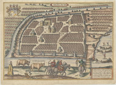
Duval - Pair: Map of Georgia & Map of Moscow, RussiaTrillium Antique Prints & Rare Books4.5(30)See Sold PriceFeb 24, 2024
1816 MAP SOUTHERN PART OF RUSSIA or MUSCOVY in EUROPE copper engraving ANTIQUEJasper524.5(9.8k)See Sold PriceFeb 27, 2024
1816 MAP NORTHERN PART OF RUSSIA or MUSCOVY in EUROPE copper engraving ANTIQUEJasper524.5(9.8k)See Sold PriceFeb 27, 2024
1758 MAP PARTIE DE LA MER GLACIALE contenants La Nouvelle Zemble RUSSIA antiqueJasper524.5(9.8k)See Sold PriceFeb 27, 2024
1749 MAP CARTE DE LA TARTARIE ORIENTALE RUSSIA & CHINA antique EASTERN TARTARYJasper524.5(9.8k)See Sold PriceFeb 27, 2024
1738 RUSSIA SIBERIA & GREAT TARTARY Description illustrated ANTIQUE in ENGLISHJasper524.5(9.8k)See Sold PriceFeb 27, 2024
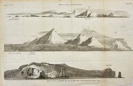
Antique Print with Coastal Views of Kamchatka in Russia by Cook, 1803Proverde Auctions4.3(3)See Sold PriceFeb 28, 2024