6 18th/19th C. Hand Colored Engraved MapsLot of six 18th/19th century hand colored engraved maps of Milanese states, Northern Asia, England and Wales, Turkey, Canada and Nova Belgica et Anglica, largest measures 21 1/4" h x 27" w. ProvenanceSee Sold Price
SoldSix Hand-Colored Engraved Maps, 18th/19th c.[18th and 19th c. Maps], a group of six hand-colored, engraved maps from Robert Sayer's @A General Atlas@, 1780, engraved by Thomas Kitchen, and others, including: "The Kingdoms of Spain and Portugal"See Sold Price
Sold4 maps, 18th-19th C. Italy + ancient geography.[Europe]. 4 engraved maps, hand-colored, double-page. ++ Homann. Novissima & Exactissima Totius Regni Neapolis. Southern Italy, including Naples, c.1740. 21 7/8 x 18 7/8 in. Tape repairs at top of verSee Sold Price
SoldSanson, ''Afrique ou Libie...,'' 1656, hand colored[Map]. Nicholas Sanson. Afrique Ou Libie Ulterieure Ou Sont Le Saara Ou Desert, Le Pays Des Negres, La Guinee & c. Engraved map, hand-colored, of most of northwestern Africa. 1656. 6 3/4 x 11 1/4.See Sold Price
SoldLot of 6 Hand Colored Engraved MapsA lot of six engraved, hand colored maps. Engraving by Wm. C. Woodbridge of MA, 1843. "The World", "South America & Africa", "Political Map Southern Division, USA", "Political Map Northern Division, USee Sold Price
SoldTallis. 2 Maps of Asia and Tibet. c.1850.[Asia] Tallis, John. (1) Map of Asia. Hand colored engraved map. 5 handcolored vignettes.London, J & F. Tallis, c.1850. (2) Map of Thibet, Mongolia, and Mandchouria. Hand colored engraved map. 6 handSee Sold Price
SoldAsia: 3 maps: Cluver, Giustiniani, Herman Moll...[Asia]. 3 engraved maps, hand-colored. Largely in very good condition. ++ Cluver. Asia. c.1690. 7 3/4 x 5 5/8 in. Faint dampstain in margins. ++ Francisco Giustiniani. Asie. 6 x 7 1/2 in. Few smudges.See Sold Price
Sold17th C. Hand Colored Engraved Map of Walachia etc.Including parts of Walachia, Serbia, Bulgaria and Romania, from Gerard Mercator's Atlas Minor, published by Jodocus Hondius, Amsterdam, 1610. matted and framed, not examined out of frame / in as-foundSee Sold Price
SoldTwo 18th C. Hand Colored Engraved Maps.From a Connecticut, CT estate. Dimensions: sheets - 17" high x 24.5" wide and 16.5" high x 25" wide. Condition: Not examined out of frames. Toned paper, trimmed margins, both with center fold creases,See Sold Price
Lot of 17 Early 19th C. Hand Colored Engraved MapsLot of seventeen early 19th century hand colored engraved maps, to include: Asia, Daenenmark, Das Konigreich Polen, Ungarn, Schweden und Norwegen, Denmark, Portugal, and various counties of England, aSee Sold Price
Sold*ANTIQUARIAN 17TH C. HANDCOLORED ENGRAVED MAPAmerica's northeast state coast line with Massachusetts, New York and possibly Virginia, as well as unexplored provinces of Canada including Quebec, approximate plate size 15" x 20", frame 21 1/2" x 2See Sold Price
Sold18TH C. HANDCOLORED ENGRAVED MAP OF AMSTERDAMDimensions: (Frame) H 15.75" x W 16", (Sight) H 9.75" x W 10.25" Condition: Some age toning and spotting.See Sold Price
Sold18th C. Map of LouisianaAn 18th C. hand-colored engraved map by Emanuel Bowen, titled "A New and Accurate Map of Louisiana with Part of Florida and Canada, and the Adjacent Countries", Plate 59. Likely from the "Complete AtlSee Sold Price
Sold18th c. Florida Map - Herman MollFLORIDA, CALLED BY YE FRENCH LOUISIANA & C., hand colored engraved map by Herman Moll (1688-1732), originally appeared in Moll's Atlas Minor (1736). 8 1/8" x 11" plate, 8 3/8" x 11 1/8" sight, 15" x 1See Sold Price
Sold18th C. Hand-Colored Map of New EnglandAn 18th C. hand-colored engraved map of New England, Nova Scotia, New France, or Canada, with the Islands of Newfoundland, Cape Breton, St. John's, by Jacques-Nicholas Bellin. Framed under glass. MatSee Sold Price
SoldGILLET, GEORGE. Connecticut from the Actual Surveys ofGILLET, GEORGE. Connecticut from the Actual Surveys of Warren & Gillet with the Addition of New Towns Turnpike Roads &c. Hand-colored engraved map of Connecticut, a reduced version of the first officiSee Sold Price
SoldAntique French Map of St. AugustineAntique French Map of St. Augustine, "Plan de la Ville et Port de St. Augustin", late 18th/early 19th c., hand-colored engraved map, sight 8 1/2 in. x 12 in., framed. Provenance: Estate of Faith K. TiSee Sold Price
Sold17th C. Hand-Colored Map of Tabula MagellanicaA 17th C. hand-colored engraved map of Tabula Magellanica, by William Blaeu. An important early map of South America showing the Strait of Magellan. Framed under glass. Mat opening: 16-1/4in x 21-1/2iSee Sold Price
Sold6 19th c. hand-colored maps of Asia6 19th c. hand-colored maps of Asia- ''Map of Asia Showing Its Political Divisions''; ''Map of Hindoostan, Farther India, China and Tibet''; ''China''; ''Asia'' (2 copies); Russia in Asia and Tartary'See Sold Price
SoldEARLY BLAEU MAP OF SOUTHEASTERN AMERICA"Virginiae partis australis, et Floridae partis orientalis, interjacentiumq, regionum Nova Descriptio", a17th c. Hand Colored Copper Engraved Map of America from Virginia to Northern Florida, by WilleSee Sold Price
SoldJohn Rapkin, (2) maps North and South AmericaJohn Rapkin, (2) maps North and South America, John Rapkin (British, 1815-1876), "North America" and "South America", c. 1851, hand-colored engraved maps with decorative border and vignettes, 14.5"h xSee Sold Price
SoldPieter Covens and Corneliu Mortier, c. 1740, MapPieter Covens and Corneliu Mortier, "L'Amerique Septentrionale.../America Septentrionali...", Amsterdam, c. 1740, hand-colored engraved map, after Delisle s seminal map of 1700, 18 1/2 in. x 23 inSee Sold Price
SoldVery Rare c. 1740 Map of AMERICA by Henry PoppleHistoric Maps “Carte Particuliere de L'Amerique Septentrionale” by Henry Popple c. 1740, Hand-Colored Engraved Map, entitled “Carte Particuliere de L'Amerique Septentrionale” by Henry Popple,See Sold Price
Soldc. 1740, Map AMERICAHistoric Maps Map “Carte Particuliere de L'Amerique Septentrionale” by Henry Popple c. 1740, Hand-Colored Engraved Map, entitled “Carte Particuliere de L'Amerique Septentrionale,” by Henry PopSee Sold Price
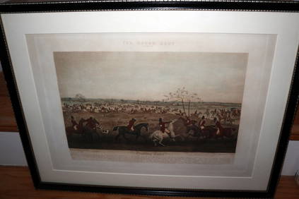
HENRY ALKEN / LEWIS Original 1835 Hand Colored Engraving Quorn Hunt DrawingLuis Porretta Fine Arts4.3(10)See Sold PriceMar 02, 2024
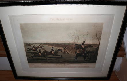
HENRY ALKEN / LEWIS Original 1835 Hand Colored Engraving Quron Hunt Snob Is BeatLuis Porretta Fine Arts4.3(10)See Sold PriceMar 02, 2024
17th Century Hand Colored Engraved Map of GermanyGlobal Auctions Company4.3(36)See Sold PriceMar 03, 2024
18th Century Hess Germany Hand colored Engraved MapGlobal Auctions Company4.3(36)See Sold PriceMar 03, 2024
Hand Colored Engraved Map of Europe, Jean Baptiste Bourguignon Anville 1754Global Auctions Company4.3(36)See Sold PriceMar 03, 2024