ATLAS of ANTIENT GEOGRAPHY by SAMUEL BUTLER 1843John McInnis Auctioneers,LLC4.5(505)See Sold PriceFeb 24, 2024
18TH C. ANTIQUE MAP: FRENCH & INDIAN WAR, FRAMEDThomaston Place Auction Galleries4.4(393)See Sold PriceFeb 24, 2024
Rand McNally Railroad Map Cabinet w/ 21 Railroad MapsRail & Road Auctions4.6(165)See Sold PriceMar 08, 2024
Keith Haring - Ink on New York Map, Best Buddies, Inscribed, Signed, and DatedSapphire Auction Gallery4.1(67)See Sold PriceMar 02, 2024
LATE 17TH C. FRENCH MAP OF THE NEW WORLD BY ALEXIS-HUBERT JAILLOT (1632-1712)Thomaston Place Auction Galleries4.4(393)See Sold PriceFeb 24, 2024
Central Railroad of New Jersey Map of Sandy Hook Route-ca. 1903JM Hobby Supply and Railroad Artifact Auctions4.4(127)See Sold PriceFeb 24, 2024
Lot of Six Mixed Atlas Box Cars-HO Scale-New in BoxJM Hobby Supply and Railroad Artifact Auctions4.4(127)See Sold PriceFeb 25, 2024
Rand McNally/Santa Fe Railroad Map of Iowa-1912JM Hobby Supply and Railroad Artifact Auctions4.4(127)See Sold PriceFeb 24, 2024
NICOLAES VISSCHER (NETHERLANDS, 1618-1709) MAP OF THE NEW WORLDThomaston Place Auction Galleries4.4(393)See Sold PriceFeb 24, 2024
17TH C. WORLD MAP BY NICOLAES VISSCHER (NETHERLANDS, 1618-1709)Thomaston Place Auction Galleries4.4(393)See Sold PriceFeb 24, 2024
Lot of Six Mixed Atlas Cabooses-HO Scale-New in BoxJM Hobby Supply and Railroad Artifact Auctions4.4(127)See Sold PriceFeb 25, 2024
Sold6 FRAMED ITEMS, TWO 18TH C. MAPS, 12 1/4" X 161/4" OVERALL, WATERCOLOR SIGNED JOAN BRUMLEY, 17" X 21" OVERALL, EARLY ENGRAVING 14 1/4" 19" OVERALL, 2 HUNGARIAN FOLK DRAWERS, 11 1/2" X 14 1/2" OVERALL, BARTOK ESTATESee Sold Price
Sold3 18th C. maps incl. R. Vaugondy and J. BaylyItem 1: Robert de Vaugondy hand colored map "Amerique septen trionale." French, 1750. 6 3/8" H x 6 1/2" W. Item 2: Robert de Vaugondy hand colored map "Mappe Monde" French, 1750. 6 3/8" H x 12 1/8" W.See Sold Price
Lot of 18th C. MapsMAP LOT. Lot of three 18th C. British maps. Double framed county maps, "Essex" and "Hereford Shire", published Sept 29, 1741, engraved by W.H. Toms, 6" x 5 3/4" viewed; "Survey of the road from ExeterSee Sold Price
SoldFrench 18th C. Map of the WorldGROUP LOT OF 6 MAPS WITH FINE ORIGINAL COLOR Louis Brion de la Tour (c. 1743 – 1803) from Louis C. Desnos' Atlas General Engraved maps with hand color in full Paris, 1779 (1783) each approximately 2See Sold Price
Sold2) FRENCH 18TH C MAPS JEMMAPES, SARDINIA & CORSICA(lot of 2) Antique French maps on paper, including: (1) "Bataille de Jemmapes le 6 9bre 1792" (Battle of Jemappes 6 November 1792), sight: approx 10.25"h, 15.25"w, overall: approx 12.5"h, 17.5"w, (1)See Sold Price
SoldEarly 18th C Handcolored Map Russia MoscoviaNicely handcolored map of Russia Sive Moscovia, text on verso. Fine, measures 8.5 x 6.5". Reserve: $50.00 Shipping: Domestic: Flat-rate of $5.00 to anywhere within the contiguous U.S. International: FSee Sold Price
Sold18th C. Cuban Map Engraving on Copper18th C. Cuban Map Engraving on Copper. Image size: 6.5 x 9 inches.See Sold Price
Sold6 PCS, 18TH & 19TH C MEDICAL BOOKS, LEATHERBOUNDCollection of medical volumes comprising Smith and Horner "Anatomical Atlas - Illustrative of the Structure of the Human Body" -1845, Thomas Dobson "The Elements of Medicine or a Translation of the ElSee Sold Price
Sold(18th c) NEW AND ACCURATE MAP OF THE WORLDAs recorded by circum-navigators Ferdinand Magellan, Sir Francis Drake and Commodore Anson by Eman Bowen geographer to His Majisty. Vol. 1 page 6. 16 x 23 inches.See Sold Price
(4) eglomise matted antique engravings and maps(4) eglomise matted antique engravings and maps, 18th/19th c., gold leaf and faux tortoise matting, larger: 8.5" x 12.5" (sight), smaller: 9.5" x 6.25" (sight), framedSee Sold Price
Sold2 German Maps and 4 French books, 18th c.Lot of 6 European books & documents. 1ST ITEM: Two German maps, one depicting the Kingdom of Hanover and the other depicting a German village with central school and church. Both retailed by Franz LaFSee Sold Price
SoldFour 17th-18th C. Maps: Desing, Manesson-MallettCollection of four 17th and 18th European maps, Item 1: P. A. Desings map of the western hemisphere. Hand colored copper engraving published in 1741. 6 3/8" H x 5 3/4" W. Items 2 and 3: Two Manesson-See Sold Price
SoldSET OF (6) CELESTIAL COLORED ENGRAVINGS18th c., SYSTEME DE DESCARTES; COSMOGRAPHIE ou Science du Monde; and SYSTEME DE L’UNIVERS SELON TICHO; the other (3) various landscapes with celestial maps in sky, 6 by 4.25 in. (sight), all similarSee Sold Price
SoldMaps, Christoph Weigel [Group of 6][Group of 6 maps by Christoph Weigel, hand-color, all measuring approx. 15" x 12", all 18th c.] **** 1: Ducatus Carnioliae. 3" cut to lower left margin, 1" closed tear to lower margin, vertical creaseSee Sold Price
Japan, 18th c.Japanese old stamped map.Fold: 16x9cm – 6.2x3.5’’Unfold: 85x37cm – 33.4x14.5’’See Sold Price
Sold[Greece/Turkey]. 6 Maps On 5 sheets. [18th-19th C[Greece/Turkey]. 6 Maps On 5 sheets. [18th-19th Century]. 15.5 x 14.5 to 18 x 20 inches. Outline/wash color. Includes Stackhouse's Ancient Greece, 1783; Attica and Turkish Dominions In Europe [two mapSee Sold Price
6 18th/19th C. Hand Colored Engraved MapsLot of six 18th/19th century hand colored engraved maps of Milanese states, Northern Asia, England and Wales, Turkey, Canada and Nova Belgica et Anglica, largest measures 21 1/4" h x 27" w. ProvenanceSee Sold Price
SoldMAP OF NEW ENGLAND AND NEW YORK BY ROBERTMARDEN, LATE 18TH OR EARLY 19TH C, HAND COLORED, EXCELLENT CONDITION. NEW FRAME, MAT AND UV GLASS. SIGHT SIZE 7" X 6", OVERALL 16 1/2" X 14 3/4".See Sold Price
SoldGrp: 6 Maps of Italy 18th-19th c.Group of 18th and 19th century maps of Italy. This group includes one map of Italy, Sardinia, Corsica, and Sicily by Carolo Allard; one map of Sicily by Jan Jansson (1588-1664) with an insert detailinSee Sold Price
Sold18th C. Map of LouisianaAn 18th C. hand-colored engraved map by Emanuel Bowen, titled "A New and Accurate Map of Louisiana with Part of Florida and Canada, and the Adjacent Countries", Plate 59. Likely from the "Complete AtlSee Sold Price
SoldFRAMED RARE 18TH C. MAP OF CORFU BY HOMANNSPlan de la Place de Corfu avec ses Environs Assiegee Par les Infideles, tranchee ouverte le 25me Juillet jusqu'au 22 me d'Aout, Iour de la Fuite des Ottomans". Homann, J. B. Circa 1740. Hand colored cSee Sold Price
Sold18th C Map Ancient World JerusalemEngraved plate showing maps of ancient world including inset of Judea and Samaria and one of Jerusalem. Early 18th century.Very Good, trimmed to plate lines, measures 7 x 5.5". Reserve: $20.00 ShippinSee Sold Price
Sold(6) 18th C Chinese Export Items(6) 18th C Chinese Export Items. 10" X 6 3/4" (Largest)See Sold Price
Sold(6) 18TH C. BEECH WOOD SIDE CHAIRSStripped beech wood, 18th century, possibly Dutch. With Greek key upholstery. Dimensions: H 38.5" x W 21.5" x D 17" x SH 19.5" Condition: Stripped, showing various layers of build up. Some small damagSee Sold Price
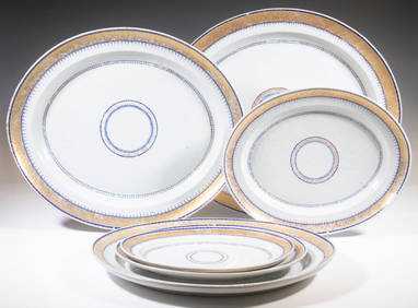
CHINESE EXPORT PORCELAIN NESTED PLATTERSThomaston Place Auction Galleries4.4(393)See Sold PriceFeb 24, 2024
PR OF 18TH C. CHINESE EXPORT DISHESThomaston Place Auction Galleries4.4(393)See Sold PriceFeb 24, 2024
18TH C. PEWTER & PASTE STONE SHOE BUCKLES IN ORIGINAL CASEThomaston Place Auction Galleries4.4(393)See Sold PriceFeb 24, 2024
EARLY 18TH C. MAP OF ITALY, FRAMEDThomaston Place Auction Galleries4.4(393)See Sold PriceFeb 24, 2024
18TH C. ANTIQUE MAP: FRENCH & INDIAN WAR, FRAMEDThomaston Place Auction Galleries4.4(393)See Sold PriceFeb 24, 2024
18TH C. GILT ALTAR FIGURE OF BODHISATTVAThomaston Place Auction Galleries4.4(393)See Sold PriceFeb 24, 2024
18th C. CHINESE EXPORT ROSE MEDALLION PITCHERLewis & Maese Antiques & Auction4.4(527)See Sold PriceFeb 25, 2024
Two (2) Antique 18th C. Copper Engraved Framed Maps - America & EuropeMagnusson Art Group4.5(53)See Sold PriceMar 14, 2024
Map: An 18thC engraved and hand coloured map of Buckinghamshire after Robert Morden. Approx. 8 1/4"Claydon Auctioneers Ltd4.3(125)See Sold PriceFeb 26, 2024
Map: An 18thC engraved and hand coloured map of Northamptonshire, with description ofClaydon Auctioneers Ltd4.3(125)See Sold PriceFeb 26, 2024
Map: An 18thC engraved and hand coloured map of North America and South America, titled DeClaydon Auctioneers Ltd4.3(125)See Sold PriceFeb 26, 2024
Map: An 18thC engraved map of Bedfordshire titled An Accurate Map of the County of Bedford DividedClaydon Auctioneers Ltd4.3(125)See Sold PriceFeb 26, 2024
Map: An 18thC engraved map titled A New and Improved Map of Oxfordshire.. after Thomas Kitchin.Claydon Auctioneers Ltd4.3(125)See Sold PriceFeb 26, 2024
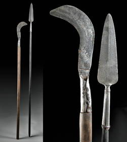
18th C. European Iron Polearms - Spear + BillhookArtemis Fine Arts4.8(1.4k)See Sold PriceFeb 26, 2024
Antique Chinese Yongcheng Porcelain Bangchuiping VaseLion and Unicorn4.8(1.9k)See Sold PriceMar 13, 2024
Nepalese Gilt Bronze Figure of Indian Goddess DurgaLion and Unicorn4.8(1.9k)See Sold PriceMar 14, 2024


![Maps, Christoph Weigel [Group of 6] (1 of 7)](https://p1.liveauctioneers.com/3532/79779/41533565_1_x.jpg?height=282&quality=70&version=1444167022)

![[Greece/Turkey]. 6 Maps On 5 sheets. [18th-19th C (1 of 0)](https://p1.liveauctioneers.com/dist/images/placeholder.jpg?height=282&quality=70)