Sold18th C. Cuban Map Engraving on Copper18th C. Cuban Map Engraving on Copper. Image size: 6.5 x 9 inches.See Sold Price
Sold4 copper engraving maps4 copper engraving maps, 18th C., 1x Rheinverlauf of F. de Wit, cartouche and borders colored, bow folds, approx. 22.5x103cm; Palatinatus Rheni of Janssonius, partially colored, approx. 38x48cm; LineSee Sold Price
SoldJohann Gabriel Doppelmayr (1677-1750), "HemisphaeriumJohann Gabriel Doppelmayr (1677-1750), "Hemisphaerium Coeli Australe," 18th c., hand colored celestial map copper engraving published by Johan Baptiste Homann, Nuremburg, framed, H.- 20 5/8 in., W.- 2See Sold Price
SoldRARE 18TH C. MAP OF THE TOWER OF LONDON IN TUDOR TIMES"A True and Exact Draught of the Tower Liberties, survey'd in the year 1597 by Gulielmus Haiward and J. Gascoyne", 1742, hand colored copper engraving, in modern gold panel frame, under French lined mSee Sold Price
18th C. Map Italy: Etats du Roy de SardaigneHand colored copper engraving atlas map on laid paper, 1787, by Clouet, J. B. L. (Jean-Baptiste Louis,) entitled "Etats du Roy de Sardaigne. (with) Isle de Sardaigne". A beautiful map, with inset, shoSee Sold Price
18thc Copper Plate Engraving, Road Map of KentOriginal, antique, copper-plate engraved, double sided Road Map of Kent, England, compiled by John Owen and engraved by Emmanuel Bowen in the 1720 edition of Britannia Depicta or Ogilby Improved. FramSee Sold Price
SoldCopper engraving map, Joh. Baptist Homann NurembergCopper engraving map, Joh. Baptist Homann Nuremberg, 18th C., Judaea and Palaestina, partly colored, two cartouches, upper with representation of Moses, who receives the Ten Commandments, smoothed creSee Sold Price
SoldHomann Heirs (German, 18th c.) World MapHomann Heirs (German, 18th c.) , "Planiglobii Terrestris Mappa Universalis...", double page, double hemisphere, world map, hand-colored copper engraving, 1746, with four hemispheric projections, two cSee Sold Price
2 18th C. European Maps, Bowen & BuchhandlungTwo (2) 18th C. European Maps, including Bowen & Buchhandlung. 1st item: "Plan der Action bey Sandershausen" Map, published by Raspischen Buchhandlung , Nuremberg, circa 1760. Copper plate engraving wSee Sold Price
2 18th C. European Maps, Bowen & Buchhandlung1st item: "Plan der Action bey Sandershausen" Map, published by Raspischen Buchhandlung , Nuremberg, circa 1760. Copper plate engraving with hand coloring of Sandershausen with a schematic view of theSee Sold Price
2 18th C. European Maps, Bowen & Buchhandlung1st item:"Plan der Action bey Sandershausen" Map, published by Raspischen Buchhandlung , Nuremberg, circa 1760. Copper plate engraving with hand coloring of Sandershausen with a schematic view of theSee Sold Price
Sold2 18th C. European Maps, Bowen & BuchhandlungTwo (2) 18th C. European Maps, including Bowen & Buchhandlung. 1st item: "Plan der Action bey Sandershausen" Map, published by Raspischen Buchhandlung , Nuremberg, circa 1760. Copper plate engraving wSee Sold Price
SoldRARE 18TH C. VARIANT OF DUTCH MAP OF FLORIDA AND"'T Amerikaans Gewest van Florida Door Ferdinand de Soto Nader Ontdekt en groot deels Bemagtigd." Published by Leiden: Pieter van der Aa, 1706, Copper engraving. Uncolored. With an additional line ofSee Sold Price
SoldFour 17th-18th C. Maps: Desing, Manesson-MallettCollection of four 17th and 18th European maps, Item 1: P. A. Desings map of the western hemisphere. Hand colored copper engraving published in 1741. 6 3/8" H x 5 3/4" W. Items 2 and 3: Two Manesson-See Sold Price
Sold18th c. H/C Map Flamsteed and Fortin 177618th Century hand-colored engraved Celestial Map / Zodiac Map Entitled Le Lynx, Le Petit Lion (Lynx, Small Lion), plate 5, from "Atlas Céleste de Flamstéed, approuvé par l'Académie Royale des ScieSee Sold Price
SoldA Tobias Conrad Lotter handcoloured map of theA Tobias Conrad Lotter handcoloured map of the Seventeen Provinces of the Low Countries copper engraving, 18thC and period, 46,5 x 48,5 cmSee Sold Price
SoldFünf Karten zu fränkischen Gebieten — 17. und 18.Five maps of Franconian areas — 17th and 18th C. ''Totius Franconiae Nova Descriptio'', cartographer Gerhard Mercator; copper engraving published by Joan Janssonius, Amsterdam around 1638; EnglSee Sold Price
Seutter Map of Mexico Southern US & Gulf 1700sMappa Geographica Regionem Mexicanam et Floridam. By Matthaeus Seutter. Hand-colored copper plate engraving, circa early 18th c. 20 x 24" plate size. Some tears at bottom and a few other margins.See Sold Price
Sold2 maps. Inc: Afrique. Atlas Methodique. 1761.[Africa] 2 maps. (1) Claude Buy de Mornas (French, 18th c.). "Afrique." 1761-1762. Hand-colored copper plate engraving, flanked by text panels in French. From "Atlas methodique et elementaire de ge´oSee Sold Price
SoldAn 18th Century Map of Poland,Guillaume De L'Isle, published paris, c.1702, with cartouche which reads 'La Pologne Dressee sur ce qu'en ont donne Starovolsk, Beauplan, Hartnoch . . .', copper engraving, uncoloured, verso plane, diSee Sold Price
SoldTwo historical maps of the 18th century, Germany andTwo historical maps of the 18th century, Germany and Denmark, ''Imperium Romano-Germanicum ...'' (Central Germany). Copper engraving, Matthias Seutter c. 1730, ''Regni Daniae ...'', copperplate engravSee Sold Price
SoldMid-18th Century Map by Heirs of Johann HomannDominia Anglorum in America Septentrionale… Homann Heirs (18th century). Copper-plate engraving with original hand color in part. Nuremberg: Homann, c. 1745. 20 1/2 x 23 inches sheet. In the mid-18tSee Sold Price
Sold18th C. Map, Engraving on Paper, Chios Greece18th Century map, engraving on paper, Chios Harbor, Greece, image 12 1/2" x 18 1/4", sheet 19 1/4" x 14 1/4", mounted on paper board. Folded in center; margins soiled; minor surface dirt.See Sold Price
LATE 18TH C. VERY LARGE CHART OF NORTHEAST CANADA BY DES BARRES (1721-1824), 1780, FRAMEDThomaston Place Auction Galleries4.4(393)See Sold PriceFeb 24, 2024
LARGE LATE 17TH C. DUTCH CHART OF CANADA, GREAT LAKES, NEW FRANCE, LABRADOR, HUDSON BAY, BY PIERREThomaston Place Auction Galleries4.4(393)See Sold PriceFeb 24, 2024
EARLY 18TH C. DUTCH CHART OF PACIFIC OCEAN BY FREDERIK DE WIT (1629-1706) WITH CALIFORNIA AS ANThomaston Place Auction Galleries4.4(393)See Sold PriceFeb 24, 2024
LARGE EARLY 18TH C. DUTCH CHART OF UPPER NORTH AMERICA, PIERRE MORTIER (1661-1711), FRAMEDThomaston Place Auction Galleries4.4(393)See Sold PriceFeb 24, 2024
EARLY 18TH C. MAP OF ITALY, FRAMEDThomaston Place Auction Galleries4.4(393)See Sold PriceFeb 24, 2024
18TH C. ANTIQUE MAP: FRENCH & INDIAN WAR, FRAMEDThomaston Place Auction Galleries4.4(393)See Sold PriceFeb 24, 2024
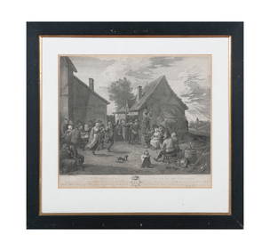
AFTER TENIERS, c.1797 'The Village Festival' Copper plate engraving, 44 x 50cm Together with; AfterAdam's Auctioneers4.3(5)See Sold PriceFeb 27, 2024
Johann Homann Hand-Colored Map Engraving, c. 1730Auctions at Showplace4.6(740)See Sold PriceMar 17, 2024
Two (2) Antique 18th C. Copper Engraved Framed Maps - America & EuropeMagnusson Art Group4.5(53)See Sold PriceMar 14, 2024
1816 MAP SOUTHERN PART OF RUSSIA or MUSCOVY in EUROPE copper engraving ANTIQUEJasper524.5(9.9k)See Sold PriceFeb 27, 2024
1816 MAP NORTHERN PART OF RUSSIA or MUSCOVY in EUROPE copper engraving ANTIQUEJasper524.5(9.9k)See Sold PriceFeb 27, 2024