ATLAS of ANTIENT GEOGRAPHY by SAMUEL BUTLER 1843John McInnis Auctioneers,LLC4.6(502)See Sold PriceFeb 24, 2024
18TH C. ANTIQUE MAP: FRENCH & INDIAN WAR, FRAMEDThomaston Place Auction Galleries4.4(386)See Sold PriceFeb 24, 2024
Rand McNally Railroad Map Cabinet w/ 21 Railroad MapsRail & Road Auctions4.6(165)See Sold PriceMar 08, 2024
Keith Haring - Ink on New York Map, Best Buddies, Inscribed, Signed, and DatedSapphire Auction Gallery4(67)See Sold PriceMar 02, 2024
LATE 17TH C. FRENCH MAP OF THE NEW WORLD BY ALEXIS-HUBERT JAILLOT (1632-1712)Thomaston Place Auction Galleries4.4(386)See Sold PriceFeb 24, 2024
Central Railroad of New Jersey Map of Sandy Hook Route-ca. 1903JM Hobby Supply and Railroad Artifact Auctions4.4(126)See Sold PriceFeb 24, 2024
Lot of Six Mixed Atlas Box Cars-HO Scale-New in BoxJM Hobby Supply and Railroad Artifact Auctions4.4(126)See Sold PriceFeb 25, 2024
Rand McNally/Santa Fe Railroad Map of Iowa-1912JM Hobby Supply and Railroad Artifact Auctions4.4(126)See Sold PriceFeb 24, 2024
NICOLAES VISSCHER (NETHERLANDS, 1618-1709) MAP OF THE NEW WORLDThomaston Place Auction Galleries4.4(386)See Sold PriceFeb 24, 2024
17TH C. WORLD MAP BY NICOLAES VISSCHER (NETHERLANDS, 1618-1709)Thomaston Place Auction Galleries4.4(386)See Sold PriceFeb 24, 2024
Lot of Six Mixed Atlas Cabooses-HO Scale-New in BoxJM Hobby Supply and Railroad Artifact Auctions4.4(126)See Sold PriceFeb 25, 2024
SoldMap of North America and West Indies, 1783Map of North America with the West India Islands, divided, showing United States and British dominions, dated 1783, hand-colored, 41 3/4" x 48", in silver leaf frame 45" x 52". Labeled Old Print Shop,See Sold Price
Sold[Map] New Map North America 1855Jacob Monk ,Baltimore; North America and Territories, Canada,Central America and West Indies, 57 x 62 in. Large Roll down map.See Sold Price
SoldTrollope (Anthony) North AmericaTrollope (Anthony) North America,2 vol., second edition, folding map (with repair to verso), 1862; The West Indies and the Spanish Main, first edition, hand-coloured map,1859, contemporary halSee Sold Price
SoldWoodbridge: Antique Map of North America & West IndiesWOODBRIDGE, W.C. . London: Whittaker, 1821. From "Modern Atlas". Approximately 8-1/2 x 10-1/2, in plastic sleeve. Right margin a little close trimmed (no loss of image), else fine. Depicts the North ASee Sold Price
SoldAmerica.- West Indies.- Sayer (Robert) and JohnAmerica.- West Indies.- Sayer (Robert) and John Bennett. A New and Correct Map of North America, with the West India Islands. Divided According to the Last Treaty of Peace..., large detailed 4 sheet mSee Sold Price
Sold[Map] Seale, Richard. Map of North AmericaSeale, Richard William. A Map of North America with the European Settlements & Whatever Else is Remarkable in ye West Indies.... [London, c.1745.] Sheet measuring 505mm x 408mm. Rather toned, 2" closeSee Sold Price
SoldLAURIE & WHITTLE. Chart containing the CoastsLAURIE & WHITTLE. Chart containing the Coasts of California, New Albion [etc.] / North America and the West Indies. Together, 2 engraved folding maps joined, issued separately but intended to be joineSee Sold Price
Americas.- Sayer (Robert) and John Bennett. A New MapAmericas.- Sayer (Robert) and John Bennett. A New Map of the Whole Continent of America, Divided into North and South and West Indies, large-scale 4 sheet map, with extensive details and rococo-styleSee Sold Price
Sold[NORTH AMERICA/CANADA]. 6 hand-colored lithog[NORTH AMERICA/CANADA]. 6 hand-colored lithograph maps. Very good condition. ++ 2 published by Thomas, Cowperthwait & Co., Phila., 1850. Each about 12 1/2 x 15 5/8. (1) Canada West Formerly Upper CanaSee Sold Price
SoldArrowsmith Map of West IndiesChart of the West Indies and Spanish Dominions in North America. Aaron Arrowsmith (1750-1823). Engraved map in four parts. London: Aaron Arrowsmith, 1803. Each approximately: 25 x 37 1/2 inches sheet,See Sold Price
SoldDavenport- New GazetteerDavenport, Bishop, ''New Gazetteer, or Geographical Dictionary, of North America and The West Indies'', George McDowell & Son, Baltimore, 1832, 1st edition, 471 pp, illustrated with 2 folding maps inSee Sold Price
SoldMap of America and West IndiesDraughts and Plans of Principal Towns and Harbours Eman Bowen 15 3/4" x 18 1/2" (sheet) 18th centurySee Sold Price
SoldDe Jode’s rare map of North AmericaAmericae Pars Borealis, Florida, Baccalaos, Canada, Corterealis. Cornelis De Jode (1509-1591). Engraved map Antwerp, 1593. 22 x 27 1/2 inches sheet, 27 1/4 x 32 1/2 inches framed. De Jode’s rare mapSee Sold Price
Sold1797 Map of North America attributed to MorseMap of North America with California as New Albion and the Snake River as the Great River of the West, ink on paper, attributed to Morse, 1797. Dimensions: Map 10-1/4"W x 8"L; framed 15-1/2"W x 13-1/2See Sold Price
1797 Map of North America attributed to MorseMap of North America with California as New Albion and the Snake River as the Great River of the West, ink on paper, attributed to Morse, 1797. Dimensions: Map 10-1/4"W x 8"L; framed 15-1/2"W x 13-1/2See Sold Price
1797 Map of North America attributed to MorseMap of North America with California as New Albion and the Snake River as the Great River of the West, ink on paper, attributed to Morse, 1797. Dimensions: Map 10-1/4"W x 8"L; framed 15-1/2"W x 13-1/2See Sold Price
1797 Map of North America attributed to MorseMap of North America with California as New Albion and the Snake River as the Great River of the West, ink on paper, attributed to Morse, 1797. Dimensions: Map 10-1/4"W x 8"L; framed 15-1/2"W x 13-1/2See Sold Price
1797 Map of North America attributed to MorseMap of North America with California as New Albion and the Snake River as the Great River of the West, ink on paper, attributed to Morse, 1797. Dimensions: Map 10-1/4"W x 8"L; framed 15-1/2"W x 13-1/2See Sold Price
1797 Map of North America attributed to MorseMap of North America with California as New Albion and the Snake River as the Great River of the West, ink on paper, attributed to Morse, 1797. Dimensions: Map 10-1/4"W x 8"L; framed 15-1/2"W x 13-1/2See Sold Price
1797 Map of North America attributed to MorseMap of North America with California as New Albion and the Snake River as the Great River of the West, ink on paper, attributed to Morse, 1797. Dimensions: Map 10-1/4"W x 8"L; framed 15-1/2"W x 13-1/2See Sold Price
1797 Map of North America attributed to MorseMap of North America with California as New Albion and the Snake River as the Great River of the West, ink on paper, attributed to Morse, 1797. Dimensions: Map 10-1/4"W x 8"L; framed 15-1/2"W x 13-1/2See Sold Price
1797 Map of North America attributed to MorseMap of North America with California as New Albion and the Snake River as the Great River of the West, ink on paper, attributed to Morse, 1797. Dimensions: Map 10-1/4"W x 8"L; framed 15-1/2"W x 13-1/2See Sold Price
SoldD'Anville (J.B.B.) Continent of AmericaD'Anville (J.B.B.) After. A Map of the Whole Continent of America,divided into North and South and West Indies, with a Copious Table, 2-sheet map, inset map of Baffins Bay and Hudsons Bay, andSee Sold Price
Two Jefferys maps West Indies & South America BritTwo Jefferys maps West Indies & South America British (ca. 1710-71) "West Indies" and "South American" hand-colored engravings. (Good condition, trimmed) paper sizes: H8" W10 1/4" and H8" W12 1/2"See Sold Price
The McAlpin Horner Merganser Hen Decoy by Nathan Rowley Horner (1882-1942)Copley Fine Art Auctions4.5(40)See Sold PriceFeb 24, 2024
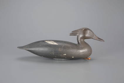
The Muller Horner Goose Decoy by Nathan Rowley Horner (1882-1942)Copley Fine Art Auctions4.5(40)See Sold PriceFeb 24, 2024
Carey, pub. 1796 - Map of GeorgiaTrillium Antique Prints & Rare Books4.5(30)See Sold PriceFeb 24, 2024
Carey, pub. 1796 - Map of The State of South CarolinaTrillium Antique Prints & Rare Books4.5(30)See Sold PriceFeb 24, 2024
Carey, pub. 1796 - Map of KentuckyTrillium Antique Prints & Rare Books4.5(30)See Sold PriceFeb 24, 2024
Carey, pub. 1796 - Map of the Tennassee State formerly part of North Carolina (Tennessee)Trillium Antique Prints & Rare Books4.5(30)See Sold PriceFeb 24, 2024
Map: An 18thC engraved and hand coloured map of North America and South America, titled DeClaydon Auctioneers Ltd4.3(125)See Sold PriceFeb 26, 2024
1822 MAP of NORTH & SOUTH AMERICA GEOGRAPHICAL STATISTICAL HISTORICAL antiqueJasper524.5(9.8k)See Sold PriceFeb 27, 2024
1862 North America Anthony Trollope West Indies AND Spanish Main CANADA NIAGARAJasper524.5(9.8k)See Sold PriceFeb 27, 2024
Map of Mexico, Central America, New Grenada, Venzuela and the West IndiesJasper524.5(9.8k)See Sold PriceFeb 27, 2024
New and Correct Map of North America With the West India Islands,Jasper524.5(9.8k)See Sold PriceFeb 27, 2024
Mexico, Central America and West Indies Physical PoliticalJasper524.5(9.8k)See Sold PriceFeb 27, 2024
Framed Tropical West Indies Map PrintRapid Estate Liquidators and Auction Gallery4.5(1.1k)See Sold PriceFeb 26, 2024
Map of United States of North America, 1785Antiques Online Auctions4.6(407)See Sold PriceMar 14, 2024
Herman Moll A New Map of Ye North Parts of AmericaWillow Auction House4.5(283)See Sold PriceMar 14, 2024


![[Map] New Map North America 1855 (1 of 4)](https://p1.liveauctioneers.com/523/85328/43939935_1_x.jpg?height=282&quality=70&version=1455914464)


![[Map] Seale, Richard. Map of North America (1 of 4)](https://p1.liveauctioneers.com/3532/91776/46880446_1_x.jpg?height=282&quality=70&version=1469669287)

![[NORTH AMERICA/CANADA]. 6 hand-colored lithog (1 of 1)](https://p1.liveauctioneers.com/179/10971/2682757_1_x.jpg?height=282&quality=70&version=1162265652)