3 Antique German Maps by Matthaeus Seutter & GuillaumeSeutter, Matthaeus, (German 1678-1756) Plan De Mayence et des Environs , De L'Isle, Guillaume Le cours du Rhin depuis Worms, jusqua Bonne, et les pays adjacens , Topographical Views of Treverts, CobolSee Sold Price
Sold(3) ANTIQUE MAPS, SPAIN, PORTUGAL, SAXONY, 18TH C.(lot of 3) Antique maps, including: (1) "Saxonie Inferioris Circulus...," c.1730, Georg Matthaus Seutter (German, 1678-1757), hand colored, approx 20.5"h, 23.75"w; (1) "La Catalogna Li Regni Di AragonSee Sold Price
SoldSeutter: Antique Map of Brandenburg & Pomerania, 1740Title/Content of Map: Brandenburg & Pomerania region of Germany & Poland Date Printed: c1740 Cartographer: Matthaus Seutter Material/Medium: Paper Size: 19 1/2" x 23 3/4" Original hand colored copperpSee Sold Price
SoldAntique German map, part of Europe.Antique German map, part of Europe: Bohemia, Bavaria, Silesia, etc. 10 3/4" x 14", frame 19 1/2" x 22 /4", under glass. Should be 17 - early 18th Century as sides of the world are upside down.See Sold Price
Antique German Map by ZannoniMade by Giovanni Rizzi Zannoni; titled "L'Alemagne Divisée par Cercles"; published by Atlas Géographique, chez Lattré, Paris, c.1762; measures approximately 12" x 17.3"; hand watercolor; handSee Sold Price
Antique German Map by FeerMade by Johannes Feer; titled "Erpach Graffschafft Erpach Comitatus"; published in Zurich, c.1800; measures approximately 13.3" x 18.1"; hand-colored; hand-laid paper is somewhat toned affecting the mSee Sold Price
Antique German map, part of Europe.Antique German map, part of Europe: Bohemia, Bavaria, Silesia, etc. 10 3/4" x 14", frame 19 1/2" x 22 /4", under glass. Should be 17 - early 18th Century as sides of the world are upside down.See Sold Price
SoldAntique Map of the Holy Land LotLot of 3 antique maps of the Holy Land: (1). "Judea seu Tarra Sancta quae Hebraeorum sive Israelitarum … Geographicis Gulielmi". Latin. Hand-colored copperplate engraving. By Guillaume Sanson. FSee Sold Price
SoldSeutter (M) 3 maps of east GermanySeutter (Matthaeus) Anhaltinus Principatus Stirpis Ascaniensis; Dynastiae Comitato Schoenburgici; Praefecturarum Colditium Leissnigium, Rochlitium,four maps of eastern Germany, 3 with decoratiSee Sold Price
SoldSeutter (M) 3 maps of northern GermanySeutter (Matthaeus) Marchia sive Electoratus Brandenburgicus nec non Ducatus Pomeraniae...; Electoratus sive Marchia Brandenburgensis; Saxoniae Inferioris Circulus, the Baltic coast of northerSee Sold Price
SoldMatthäeus Seutter (German, 1678-1757) MapMatthäeus Seutter (German, 1678-1757), "Diversi Globi Terr-Aquei Statione Variante...", Augsburg, c. 1735, hand-colored twin-hemisphere map, incorporating eight equatorial and polar projections, decoSee Sold Price
A MATTHAUS SEUTTER (GERMAN, 1678-1757) ANTIQUE MAP OF TA MATTHAUS SEUTTER (GERMAN, 1678-1757) ANTIQUE MAP OF THE AMERICAS ""NOVUS ORBIS/ SIVE/ AMERICA/MERIDIONALIS ET SEP/TENTRIONALIS"" 1730 AND A PIERRE VANDER (FRENCH, 1659-1733) ANTIQUE MAP OF TURKEY ANSee Sold Price
Seutter: Antique Map Balkans, Hungary to Greece, 1740Title/Content of Map: Balkan's from Hungary to Greece Date Printed: c1740 Cartographer: Matthaus Seutter Material/Medium: Paper Size: 23 1/2" x 19 3/4" Original hand colored copperplate engraved. PublSee Sold Price
Seutter: Antique Map of Spain and Portugal, 1740Title/Content of Map: Spain and Portugal Date Printed: c1740 Cartographer: Matthaus Seutter Material/Medium: Paper Size: 23 1/2" x 19 3/4" Original hand colored copperplate engraved. Published in AugsSee Sold Price
SoldSeutter Antique Hand Coloured Map of JamaicaMatthaeus Seutter (1678-1756) Antique Hand Coloured Map of Jamaica Titled Nova Designatio Insulae Jamaicae. Map measures 20 inches H x 23 within matting, frame measures 28 x 31 inches.See Sold Price
Seutter: Antique Map of Italy, 1740Title/Content of Map: Italy by Seutter Date Printed: c1740 Cartographer: Matthaus Seutter Material/Medium: Paper Size: 19 2/3" x 23 1/3" Original hand colored copperplate engraved. Published in AugsbuSee Sold Price
Seutter: Antique Map of British Islands, 1740Title/Content of Map: British Islands by Seutter Date Printed: c1740 Cartographer: Matthaus Seutter Material/Medium: Paper Size: 19 1/2" x 23 2/3" Original hand colored copperplate engraved. PublishedSee Sold Price
SoldSeutter: Antique Map of Corsica, 1740Title/Content of Map: Insula Corsica olim Regni Titulo Insignis Cartographer: Seutter Place & Date: Augsburg / 1740s Size: 19 1/2" x 22 3/4" Condition: old wash color on island, cartouche uncolored; oSee Sold Price
SoldSeutter: Antique Map of France, 1740Title/Content of Map: France by Seutter Date Printed: c1740 Cartographer: Matthaus Seutter Material/Medium: Paper Size: 23 3/4" x 19 3/4" Original hand colored copperplate engraved. Published in AugsbSee Sold Price
SoldSeutter: Antique Map of Switzerland with Alpine ViewsTitle/Content of Map: Switzerland showing magnificent cartouches of alpine views Date Printed: c1740 Cartographer: Matthaus Seutter Material/Medium: Paper Size: 23 2/3" x 20" Original hand colored copSee Sold Price
Seutter: Antique Map of Prussia & Baltic Coast, 1740Title/Content of Map: Prussia with the Baltic Coast Date Printed: c1740 Cartographer: Matthaus Seutter Material/Medium: Paper Size: 19 1/2" x 23 2/3" Original hand colored copperplate engraved. PublisSee Sold Price
Seutter: Antique Map of Scandanavia, 1740Title/Content of Map: Scandanavia by Seutter Date Printed: c1740 Cartographer: Matthaus Seutter Material/Medium: Paper Size: 19 1/3" x 23 2/3" Original hand colored copperplate engraved. Published inSee Sold Price
SoldSeutter: Antique Map of Portugal, Brazil Insert, 1740Title/Content of Map: Portugal with a magnificent cartouche and large insert of Brazil Date Printed: c1740 Cartographer: Matthaus Seutter Material/Medium: Paper Size: 23 1/2" x 19 2/3" Original hand cSee Sold Price
Seutter: Antique Map of Northwest Russia, 1740Title/Content of Map: Northwest Russia Moscowic Kingdom Date Printed: c1740 Cartographer: Matthaus Seutter Material/Medium: Paper Size: 19 3/4" x 23 3/4" Original hand colored copperplate engraved. PuSee Sold Price
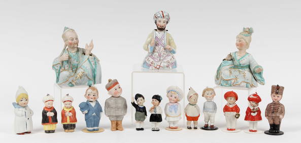
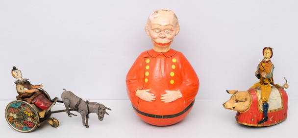
Antique German Max Handwerck 88 11 3/4 Bisque Head Composition Body DollLodestar Auctions4.6(403)See Sold PriceMar 03, 2024
Antique German Heubach Koppelsdorf 250-3 Bisque Head Composition Body DollLodestar Auctions4.6(403)See Sold PriceMar 03, 2024
Antique German Kley & Hahn 3 Bisque Head Composition Body DollLodestar Auctions4.6(403)See Sold PriceMar 03, 2024
Antique German Kley & Hahn 3 Bisque Head Composition Body DollLodestar Auctions4.6(403)See Sold PriceMar 03, 2024
Antique German Heubach Koppelsdorf 250-3 Bisque Head Baby DollLodestar Auctions4.6(403)See Sold PriceMar 03, 2024
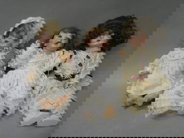
Lot 3 Antique German Bisque Dolls Simon Halbig etcLodestar Auctions4.6(403)See Sold PriceMar 03, 2024
18th Century Hess Germany Hand colored Engraved MapGlobal Auctions Company4.3(36)See Sold PriceMar 03, 2024
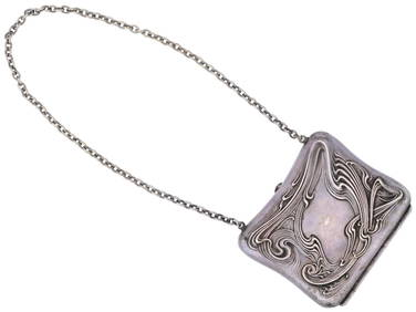
ANTIQUE GERMAN ART NOUVEAU SILVER COIN PURSE C 1910Antique Arena Inc.4.5(883)See Sold PriceFeb 24, 2024
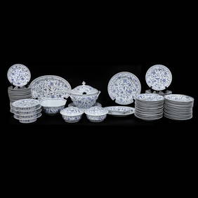
Antique German Delft Blue and White Porcelain Dishes and Serving Pieces, 92 TotalNorthgate Gallery, Inc.4.5(36)See Sold PriceMar 02, 2024
Chatelain - 3 Maps of the British Isles (England, Ireland, Scotland)Trillium Antique Prints & Rare Books4.5(33)See Sold PriceFeb 24, 2024
ANTIQUE TALL GERMAN 3 WEIGHT GRANDFATHER CLOCKRedlands Antique Auction4.8(877)See Sold PriceFeb 24, 2024
ANTIQUE GERMAN HEXAGONAL BRASS TABLE CLOCK WITH KEYAntique Arena Inc.4.5(883)See Sold PriceMar 02, 2024
Antique German Magic Lantern Projector with SlidesMatthew Bullock Auctioneers4.7(1.9k)See Sold PriceMar 02, 2024
1829 GERMAN-LANGUAGE ANTIQUE AMERICAN BIBLE ILLUSTRATED WITH MAPS OF PHILADELPHIANY Elizabeth 4.1(88)See Sold PriceMar 03, 2024
Antique Map of Poland, 1700 by Guillaume De Lisle, ParisAntiques Online Auctions4.6(419)See Sold PriceMar 14, 2024