SoldAntique German map, part of Europe.Antique German map, part of Europe: Bohemia, Bavaria, Silesia, etc. 10 3/4" x 14", frame 19 1/2" x 22 /4", under glass. Should be 17 - early 18th Century as sides of the world are upside down.See Sold Price
SoldAntique map of Europe and part of RussiaAntique map of Europe and part of Russia, 23"x38"See Sold Price
Antique Map Print - Map of Mediterranean - Parts of Europe, Africa, Middle EastTitle: Antique Map Print - Map of Mediterranean - Parts of Europe, Africa, Middle East Date: 1725 Material: Paper Dimensions: 20” x 15” inches / 50 cm x 39 cm Descritpion: Fantastic antiquSee Sold Price
Antique German Map of Western North America 1862"Vereinigte Staaten von Nordamerika". Lithograph von E. Serth after Tr. Bromme for "Tr. Bromme's Hand Atlas", 1862. Original hand coloring. Map shows the western part of the USA with major towns and cSee Sold Price
Antique German Map of Western North America 1862"Vereinigte Staaten von Nordamerika". Lithograph von E. Serth after Tr. Bromme for "Tr. Bromme's Hand Atlas", 1862. Original hand coloring. Map shows the western part of the USA with major towns and cSee Sold Price
SoldAntique German Map of Western North America 1862"Vereinigte Staaten von Nordamerika". Lithograph von E. Serth after Tr. Bromme for "Tr. Bromme's Hand Atlas", 1862. Original hand coloring. Map shows the western part of the USA with major towns and cSee Sold Price
SoldRussia 1818-1835 Pair of Antique Maps"Russian Empire" Copper Engraved Map Published 1818, London for "A New and Complete System of Universal Geography" by Christopher Kelly. Together with "Russia in Europe Part V" Steel Engraved Map PublSee Sold Price
SDUK: Antique Map of Russia, 1845TITLE/CONTENT OF MAP: 'RUSSIA IN EUROPE, PART II., Arkhangel, Vologda, Viatka, Perm' DATE PRINTED: 1845 IMAGE SIZE: Approx 34.0 x 41.5cm, 13.5 x 16.25 inches (Large) TYPE: Antique steel engraved map wSee Sold Price
SoldMINIATURE ROOM BOX."Antique German Classroom". 14" T x 19" W x 10 1/2" D. Faux wood grain walls and floor. Interior walls of classroom show: maps of Europe, Germany, Australia. "Studen Plan" and numbers and two differenSee Sold Price
Sold17th Century German / Dutch bookItem/Description: Antique book. German. Fold out illustration maps include: "Messina". Reads in part: des berunruhigten hollandilchen e loivens siebender theil darinnen. Material: N/A Dimensions: LengSee Sold Price
SoldWeller: Antique Map of Europe, 1877Title/Content of Map: Europe (Latter Part of the 10th Century.) Date Printed: 1877 ca. Cartographer: WELLER, EDW. Publisher: G.P. PUTNAM'S SONS 1877 ca. NEW YORK Size: Quarto – 6.00 H x 8.75 W IncheSee Sold Price
Antique Map Print - Europe - Roman Empire Eastern Part - Cyprus - Rigobert BonneTitle: Antique Map Print - Europe - Roman Empire Eastern Part - Cyprus - Rigobert Bonne Date/Period: 1787 Dimension: 43 cm x 30 cm Material: Paper Additional Information: Imperium Romanum Pars OrientaSee Sold Price
Thomson: Antique Map of Turkey in Europe, 1817TITLE/CONTENT OF MAP: 'North Part of Turkey in Europe comprehending Ancient Illyricum and Dacia, Moesia. &c' A large map of the northern part of Turkey in Europe, including Bosnia, Dalmatia, Servia, MSee Sold Price
SoldNeele: Antique Map of Turkey in Europe, 1783Map: The Southern & Middle Parts of Turkey in Europe. Publication Date: 1783-06-01 Authors: T. STACKHOUSE, NEELE, S. J. Publisher: T. STACKHOUSE Size: Quarto – 15.00 H x 14.25 W Inches Outline map oSee Sold Price
Delarochette: Antique Map of the German Empire, 1759Title/Content of Map: 1759 Delarochette Map of the German Empire and most of Central Europe -- Map of the Empire of Germany, Including All the States Comprehended under that Name: with the Kingdom ofSee Sold Price
Weller: Antique Map of the German Confederation, 1860Map: the German Confederation and Adjacent Countries, Showing The Principal Railways of Central Europe. Publication Date: 1860 Authors: BLACKIE & SON, WELLER, EDW. Publisher: BLACKIE & SON Size: FolioSee Sold Price
Tallis: 3 Antique Maps of Russia, 1851Title/Content of Map: 1851 Three Tallis Maps of Russia in Europe, Russia in Asia, Tartary, all in Book -- The History of Russia containing Russia in Asia; Part of Russia and Independent Tartary; RussiSee Sold Price
SDUK: Antique Map of Europe, 1845Title/Content of Map: 'EUROPE; inset table of population by country'. The map shows Lombardia-Venetia as part of the Austrian Empire, the independent Ionian Islands, and Turkish Crete Date Printed: 18See Sold Price
Tallis: Antique Maps of Russia in Europe/Asia, 1851Map: 1851 Three Tallis Maps of Russia in Europe, Russia in Asia, Tartary, all in Book -- The History of Russia containing Russia in Asia; Part of Russia and Independent Tartary; Russia in Europe ShowiSee Sold Price
Vandermaelen: Antique Map of Baltic Countires, 1827TITLE/CONTENT OF MAP: 'Europe - Partie de la Russie - No 9 ' The Baltic countries known today as Estonia, Latvia and Lithuania, the southern part of the Baltic Sea, the Gulf of Finland to Saint PetersSee Sold Price
SoldSDUK: Antique Map of Europe, 1845TITLE/CONTENT OF MAP: 'EUROPE; inset table of population by country' The map shows Lombardia-Venetia as part of the Austrian Empire, the independent Ionian Islands, and Turkish Crete DATE PRINTED: 184See Sold Price
Vandermaelen: Antique Map of Southern Finland, 1827TITLE/CONTENT OF MAP: 'Europe - Partie de la Russie d'Europe - No 5 ' Most of the southern part of Finland and the Russian region of Karelia, with part of the White Sea DATE PRINTED: 1827 IMAGE SIZE:See Sold Price
Vandermaelen: Antique Map of Greece, 1827TITLE/CONTENT OF MAP: 'Europe - Grèce - No 27 ' Greece, the Aegean and the western part of Turkey. The United States of the Ionian Islands, then a British Protectorate, are showed coloured green as aSee Sold Price
Vandermaelen: Antique Map of Northern Italy, 1827TITLE/CONTENT OF MAP: 'Europe - Partie de l'Italie - No 20 ' Most of the northern Italian states, Switzerland, the western Balkans, and the southern part of what is now Austria DATE PRINTED: 1827 IMAGSee Sold Price
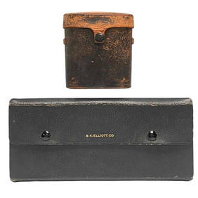
Gentleman's Lot B.K Elliot Drafting Tools and Warner & Swasey BinocularsPremier Auction Galleries4.3(329)See Sold PriceMar 09, 2024
Antique German Kampen Town Color Copper EtchingHill Auction Gallery 4.7(1k)See Sold PriceFeb 28, 2024
Two (2) Antique 18th C. Copper Engraved Framed Maps - America & EuropeMagnusson Art Group4.5(50)See Sold PriceMar 14, 2024
Carey, pub. 1796 - Map of the Tennassee State formerly part of North Carolina (Tennessee)Trillium Antique Prints & Rare Books4.5(30)See Sold PriceFeb 24, 2024
1816 MAP SOUTHERN PART OF RUSSIA or MUSCOVY in EUROPE copper engraving ANTIQUEJasper524.5(9.8k)See Sold PriceFeb 27, 2024
1816 MAP NORTHERN PART OF RUSSIA or MUSCOVY in EUROPE copper engraving ANTIQUEJasper524.5(9.8k)See Sold PriceFeb 27, 2024
1704 DESCRIPTION OF ALL THE SEATS OF THE PRESENT WARS OF EUROPE antique w/ MAPSJasper524.5(9.8k)See Sold PriceFeb 27, 2024
1738 RUSSIA SIBERIA & GREAT TARTARY Description illustrated ANTIQUE in ENGLISHJasper524.5(9.8k)See Sold PriceFeb 27, 2024
CENTRAL AFRICA. Tanzania, Kenya, Angola, Zambia, Congo, Mozambique 1903 mapJasper524.5(9.8k)See Sold PriceFeb 28, 2024
Theodor Fischer (1862 - 1938) - Set of 4 Bird Prints - Haliaetos Albicilla - Strix LapponicaProverde Auctions4.3(3)See Sold PriceFeb 28, 2024
Theodor Fischer (1862 - 1938) - Set of 4 Bird Prints - Pernis Apivorus - Falco ArcticusProverde Auctions4.3(3)See Sold PriceFeb 28, 2024