Sold2 SMALL MATTED 17TH C. MAPS, ASIA,BY CLUVER, NICE 5" X 5" AND AFRICA BY PHILLIP CLUVER, 5" X 5"See Sold Price
Soldfour small 17th c maps of parts of Africafour small 17th c maps of parts of Africa, largest 5 1/2" x 7 1/4"See Sold Price
Mid 17th C Map BavariaWilliam Janszoon Blaeu (1571-1638), "Palatinus Bavariae" (mid 17th C Map of Bavaria), hand colored, image 14-1/2" x 19-3/4", overall 21-1/4" x 26-1/2", framed and mattedSee Sold Price
Sold(2) 17TH C. MAPS OF HOLLANDBoth hand colored engravings, specific areas of Holland Dimensions: (largest open) H 20.5" x W 24" Condition: Some edge damages, losses, small spots of stainingSee Sold Price
17th/18th c Map of Rome by Christoph Weigelins17th/18th c Map of Rome by Christoph Weigelins, hand tinted print, labeled in latin, matted and framed. Appx 12 1/2" x 17 1/4" viewed, frame 19" x 24". Good condition with some discoloration in the upSee Sold Price
Sold(2) 17TH C. LATIN AMERICAN MAPS, WILLIEM BLAEUGUIANA fiue AMAZONUM REGIO, 15 by 19.75 in. (sight); the other NOVUS BRASILIA TYPUS, 15 by 20 in. both AMSTELODAMI, GUILJELMUS BLAEUW excudit both matted and framed under glassSee Sold Price
Johannes Van Keulen, Map of Brazilia, Late 17th CProperty of a Private Collection, Savannah, GA (Dutch, 1654-1715), Map of Brazilia, Late 17th C, showing the coastline, matted and framed. Frame size 26 3/4 in. x 30 1/2 in. By sight: H. 19 3/4 in. xSee Sold Price
SoldJohannes Van Keulen, Map of Brazilia, Late 17th CJohannes Van Keulen, Map of Brazilia, Late 17th C, (Dutch, 1654-1715), Map of Brazilia, Late 17th C, showing the coastline, matted and framed. Frame size 26 3/4 in. x 30 1/2 in. By sight: H. 19 3/4 inSee Sold Price
Johannes Van Keulen, Map of Brazilia, Late 17th CProperty of a Private Collection, Savannah, GA (Dutch, 1654-1715), Map of Brazilia, Late 17th C, showing the coastline, matted and framed. Frame size 26 3/4 in. x 30 1/2 in. By sight: H. 19 3/4 in. xSee Sold Price
SoldA Very Early Map of AfricaA Very Early Map of Africa possibly 17th C, "Carta Geografica della Etiopa o Abyssinia". Matted for framing, 13 1/2" h, 17 1/4" w.See Sold Price
SoldMAP: (on 2) GERMAN CITY VIEWSattrib. Braun & Hogenberg, 17th c. German town views from Civitates Orbis Terrarum hand colored copper plate engravings images measure 13.5 by 18.5 in. and 12 by 18.5 in., matted, framed under glassSee Sold Price
SoldHistorical Map of Nantucket Massachusetts, 1869Historical Nantucket map with information, points, and references for the 17th, 18th, and 19th Century. Surveyed and drawn by The Reverend F. C. Ewer, D.D., Framed and matted under glass. Small hole bSee Sold Price
(2) 17thc. Maps of Germany and Italy(2) Circa 1620 Colored Maps of Westphalia and Mantova. 15 x 19 inches each. Framed Condition: GoodSee Sold Price
Sold2 - 17THC. FRAMED MAPS OF BERMUDA, ONE BY W. BLAEU 1640 & 1 BY JANSSONIUS JOANNES (19" X 23 3/4")2 - 17THC. FRAMED MAPS OF BERMUDA, ONE BY W. BLAEU 1640 & 1 BY JANSSONIUS JOANNES (19" X 23 3/4")See Sold Price
Sold17th C. British Maps, Ogilby and John Speed2 17th C. British Maps: Ogilby's "London to Portsmouth" and John Speed's Scotland. (2 pcs.) {TC} (GALL6004/2) Measurements: The Ogilby 15 1/2 x 19 1/2, framed 18 x 21; the Speed 14 x 19, unframed PleaSee Sold Price
Sold(2) 17TH C. CONTINENTAL HAND-COLORED MAPSIL BELLUNESE Con il FELTRINO with page from its German book on reverse, noted as 1647 framed under glass, image 14.75” by 19.5”; the other LUSATIA SUPERIOR Ex Officina Davids Funck Norumbergae matSee Sold Price
SoldEARLY MAP "INSULA CANDIA EJUSQUE FORTIFICATIO",FREDRICK DE WIT, 18" X 21 1/2", POSSIBLY 17TH C. THIS MAP OF THE ISLAND OF CRETE SHOWING THE ISLAND FOLLOWING THE SIEGE OF CANDIA, 24 YEAR CONFLICT IN WHICH THE OTTOMANS BESIEGED THIS VENETIAN RULED CSee Sold Price
Soldmixed lot of 5 porcelains, Chimixed lot of 5 porcelains, China, Qing dynasty(1644-1911), 17th-19th c., 1 small pot on stand c. 1900, mark QIANLONG; 2 small spiral plates 17th/18th c.; 1 small rice wine bowl with tendril decorationSee Sold Price
Sold17th c. J. Blaeu (?) Engraved Map of Asia Minor17th c. J. Blaeu (?), 1596 - 1673 copper engraved map of Asia Minor, hand colored accents including land boarders, cities and sea serpents, hand colored figures and ships, highlighted with gold indicaSee Sold Price
SoldFOUR FINE NEEDLE LACE SAMPLES, 18TH C1 Argentan, 3" x 30", excellent; 1 Point de France, 3" x 45", fair; 1 Coraline, 3.5" x 116", excellent; 1 Alencon, 6" x 45", excellent; 1 Spanish needlelace (17th C) in 2 small pieces: 1 7" x 13" & 7"See Sold Price
SoldA late 17thC small mule chest with 2 drawers to bottomA late 17thC small mule chest with 2 drawers to bottom with brass ornamentation 37 1/2" wide x 18 3/4" deep x 27 1/4" high Please Note - we do not make reference to the condition of lots within cataloSee Sold Price
Sold17th c. Map of Ireland17th c. Map of Ireland by William Hole- ''Hiberniae Anglis, Yuerdon Britannis Erin incolis, Ierna, London, later hand-coloring, paper age toned. 11 x 13 1/2''See Sold Price
Sold17th c. Map17th c. map of Great Britain, "LE ROYAUME D' ANGLETERRE...". Loose in frame and not glued down. Sight 32" x 23 1/2". Marked and dated "A Paris chez H. Laillot 1693".See Sold Price
Sold(on 2) SMALL METAL HOLY WATER STOUP17th c., poss. Spanish Colonial, embossed standing Madonna and Child above footed container with hinged lid, 7" (very old repair on reverse; crown pierced).; along with an early NEEDLEWORK PANEL OF THSee Sold Price
17TH C. WORLD MAP BY NICOLAES VISSCHER (NETHERLANDS, 1618-1709)Thomaston Place Auction Galleries4.4(386)See Sold PriceFeb 24, 2024
LATE 17TH C. FRENCH MAP OF THE NEW WORLD BY ALEXIS-HUBERT JAILLOT (1632-1712)Thomaston Place Auction Galleries4.4(386)See Sold PriceFeb 24, 2024
17TH C. ANTIQUE MAP SIEGE OF LA ROCHELLE, FRANCE, FRAMEDThomaston Place Auction Galleries4.4(386)See Sold PriceFeb 24, 2024
17TH C. MAP OF THE BERKSHIRES BY JOHN SPEED, FRAMEDThomaston Place Auction Galleries4.4(386)See Sold PriceFeb 24, 2024
18TH C. ANTIQUE MAP: FRENCH & INDIAN WAR, FRAMEDThomaston Place Auction Galleries4.4(386)See Sold PriceFeb 24, 2024
17TH C. ENGLISH LINEAR MAP BY OGILBY, FRAMEDThomaston Place Auction Galleries4.4(386)See Sold PriceFeb 24, 2024
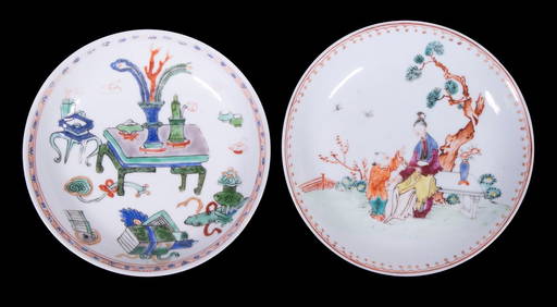
CHINESE KANGXI PERIOD PORCELAIN SAUCERSThomaston Place Auction Galleries4.4(386)See Sold PriceFeb 24, 2024
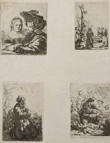
Rembrandt van Rijn. Four etchings, printed on one sheet of medium weight off-white wove paper, withTremont Auctions4.6(293)See Sold PriceFeb 25, 2024
Rembrandt van Rijn. Jan Lutma the Elder, Goldsmith (c.1656). Margins of 5/8" to 1/2". Overall size:Tremont Auctions4.6(293)See Sold PriceFeb 25, 2024
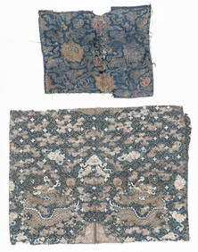
2 Antique Chinese Textile Fragments, 17th C. and 19th C.Material Culture4.6(765)See Sold PriceFeb 29, 2024
Willem Blaeu, Etc. 17th C. Antiquarian Maps, 2Auctions at Showplace4.5(726)See Sold PriceMar 17, 2024
REMBRANDT VAN RIJN (1606-1669) ETCHING TITLED MAN WITH FEATHER BARRETTE - 9.25IN x 10.75IN - 1639The Rug Life4.3(12)See Sold PriceMar 07, 2024
Map: A 17thC engraved and hand coloured map of Scotland titled Strath-Navernia / Strath Navern afterClaydon Auctioneers Ltd4.3(125)See Sold PriceFeb 26, 2024
Map: A 17thC engraved and hand coloured map of Bedfordshire after Robert Morden. Approx. 12 1/2" xClaydon Auctioneers Ltd4.3(125)See Sold PriceFeb 26, 2024
Map: A 17thC engraved and hand coloured map after Frederik de Wit (1630-1706) titled Nova Persiae,Claydon Auctioneers Ltd4.3(125)See Sold PriceFeb 26, 2024
2 SMALL PAINTINGS, 1 O/C UNFRAMED & 1 WATERCOLOR OVAL (O/C 5 1/2" X 9")Carlsen Gallery, Inc.4.6(163)See Sold PriceMar 03, 2024
ANTIQUE ROMAN ARMORIAL VELLUM BINDING, 1744, ILLUSTRATED WITH AN ANTIQUE MAP BY FLORUSNY Elizabeth 4.3(84)See Sold PriceMar 03, 2024