ATLAS of ANTIENT GEOGRAPHY by SAMUEL BUTLER 1843John McInnis Auctioneers,LLC4.6(502)See Sold PriceFeb 24, 2024
18TH C. ANTIQUE MAP: FRENCH & INDIAN WAR, FRAMEDThomaston Place Auction Galleries4.4(386)See Sold PriceFeb 24, 2024
Rand McNally Railroad Map Cabinet w/ 21 Railroad MapsRail & Road Auctions4.6(165)See Sold PriceMar 08, 2024
Keith Haring - Ink on New York Map, Best Buddies, Inscribed, Signed, and DatedSapphire Auction Gallery4(67)See Sold PriceMar 02, 2024
LATE 17TH C. FRENCH MAP OF THE NEW WORLD BY ALEXIS-HUBERT JAILLOT (1632-1712)Thomaston Place Auction Galleries4.4(386)See Sold PriceFeb 24, 2024
Central Railroad of New Jersey Map of Sandy Hook Route-ca. 1903JM Hobby Supply and Railroad Artifact Auctions4.4(126)See Sold PriceFeb 24, 2024
Lot of Six Mixed Atlas Box Cars-HO Scale-New in BoxJM Hobby Supply and Railroad Artifact Auctions4.4(126)See Sold PriceFeb 25, 2024
Rand McNally/Santa Fe Railroad Map of Iowa-1912JM Hobby Supply and Railroad Artifact Auctions4.4(126)See Sold PriceFeb 24, 2024
NICOLAES VISSCHER (NETHERLANDS, 1618-1709) MAP OF THE NEW WORLDThomaston Place Auction Galleries4.4(386)See Sold PriceFeb 24, 2024
17TH C. WORLD MAP BY NICOLAES VISSCHER (NETHERLANDS, 1618-1709)Thomaston Place Auction Galleries4.4(386)See Sold PriceFeb 24, 2024
Lot of Six Mixed Atlas Cabooses-HO Scale-New in BoxJM Hobby Supply and Railroad Artifact Auctions4.4(126)See Sold PriceFeb 25, 2024
Sold2 maps: Speede. Rutlandshire... + Sanson ...France[England/France] 2 Maps. (1) Speede, John (British, 1552-1629). "Rutlandshire With Oukham And Stanford Her Bordering Neighbour Newly Described." John Sudbury and George Humbell, London, 1612. EnglishSee Sold Price
SoldSanson Map of New FranceSanson d'Abbeville, Nicholas (1600-1667). Le Canada, ou Nouvelle France. Engraved map with original hand color. Paris: Pierre Mariette, 1656. 16" x 21 1/2" sheet, 19" x 25" framed. The First Map of CaSee Sold Price
SoldSanson d'Abbeville. Le Royaume de FranceSanson d'Abbeville (Nicolas) Le Royaume de France,France with large decorative title cartouche, engraved map on 2 sheets joined, with original outline hand-colouring, 560 x 885mm., split and cSee Sold Price
SoldMap Le Canada, ou Nouvelle France, Pub Sanson 1656Map on Laid Paper titled; Le Canada, ou Nouvelle France, published by: Nicolas Sanson, Paris France. dated 1656, paper size 18" x 23 1/2", Good Condition, 2 1/2" tear along seam, minor stains twords bSee Sold Price
Sanson Engraved Map of CanadaLe Canada, ou Nouvelle France. Nicolas Sanson d'Abbeville (1600-1667). Engraved Map with original hand color in outline. Paris: Pierre Mariette, 1656. 16 x 21 1/2 inches sheet, 19 x 25 inches framed.See Sold Price
Sold9 maps, mostly France. Jansson, [ca 1640s-1650s].9 Maps, mostly regions of France. Amst: Jansson, 1 map also credits Sanson, c. 1640s-1650s. Hand colored outline. Approx. 16 x 20 in. with variation, Sheets 19 1/2 x 23 in. Includes: ++ Territorium MeSee Sold Price
SoldMAP: NOUVELLE FRANCE, C. 1656, HC ENGRAVINGTitle: Map: Le Canada, ou Nouvelle France, Pub: Nicolas Sanson, Date: Circa 1656, Medium: HC Engraving, Paper size: 18 x 23 1/2, Inscribed: Cartographer and engraver identified within matrix, ConditioSee Sold Price
SoldHand-Painted Print of a 17th Century MapPrint of a 17th century map of the Kingdom of France by Nicolas Sanson. [Sight: 23 5/8" H x 35 1/2" W; Frame: 25 1/2" H x 37 1/2" W]. Crease marks, toning, minor foxing and minor imperfections. UnmounSee Sold Price
Sanson (Nicolas) - Le Comté et Gouvernement deregional map of southern France, decorative title cartouche of flags and arms, lower right, engraved map with original hand-colouring, on 2 sheets, joined, 595 x 900mm., slight creasing around centralSee Sold Price
SoldSanson (Nicolas) - Le Comté et Gouvernement deregional map of southern France, decorative title cartouche of flags and arms, lower right, engraved map with original hand-colouring, on 2 sheets, joined, 595 x 900mm., slight creasing around centralSee Sold Price
SoldMap of North AmericaAmerique Septentrionale par N. Sanson d'Abbeville Geog. du Roy, 17 1/2" x 23 1/2" (sight) published Paris, France 1650See Sold Price
Sanson Le Candad, 1656Sanson, D'Abbeville, Nicholas (1600-1667). Le Canada, ou Nouvelle France. Engraved map with original hand color Paris: Piette Mariette, 1656. 16" x 21 1/2" sheet, 19" x 25" framed. The first map of CaSee Sold Price
Sold(2) Maps France; 1729 and 1852(2) Maps France. 1) Plan de la Ville et Citadelle de Lille, ca. 1729. Measures 21" x 25.75"; and 2) Nouvelle Carte de La France 1852. Measures 26.75" x 21". Both tape on verso at center. Very good conSee Sold Price
Sold(2) EARLY MAPS FRANCE & DENMARK(lot of 2) Framed maps, comprising: (1) "A New Map of the Kingdom of Denmark Comprehending North and South Jutland, Zeeland, Fyen, Laaland and Part of Holstein" by John Cary, 1801, published by John CSee Sold Price
Sold2 Maps: L’Italia + Italia Antiqua.[De Rossi/Sanson/Italy] 2 Maps. ++ Nicholas Sanson. Italia Antiqua cum Itineribus antiquis. Cum Insulis Sicilia Sardinia & Corsica. Rome: Jo. Jacob. De Rubeis. [C. 1690s.] At lower left: “Joannes L�See Sold Price
SoldLOT OF TWO ANTIQUE MAPS OF WESTERN EUROPE & FRANCELOT OF TWO ANTIQUE MAPS OF WESTERN EUROPE AND FRANCE. 1. MAP OF GREATER WESTERN EUROPE. 2. MAP OF FRANCE. Height: 25 and 24 in. by Width: 37 and 30 1/2 in.See Sold Price
2 Bertius Maps. Peloponnese and France. c.1597.[Maps] Bertius, Petrus (Dutch, 1565-1629). (1) Map of Peloponnese, (2) Map of France. Amsterdam, c.1605. Copperplate engraved maps. Each map with contemporary handcolored in outline and cities in red.See Sold Price
SoldLot of 2 antique maps of FranceLot of 2 antique maps of France. Framed sizes are 21"h x 20"w and 20 1/2"h x 22"w, sight sizes are 14"h x 13"w and 13 1/4"h x 14 3/4"wSee Sold Price
2 Sanson maps. Ethiopie & L’Empire .. Perses. 1655[Middle East] Sanson, Nicolas. (1) Haute Ethiopie ou sont L’Empire Des Abissins, La Nubie, et la Zanguebar.” Paris, P. Mariette, 1655. Engraved map. 19 7/8" x 15 7/8".(2) “DescriptiSee Sold Price
SoldJan Jansson Early Map Views France (2)Early maps: Jan Jansson. Calais and Lyon. (2) Map Views in France. Hand-colored engravings. From Theatrum exhibens celebriores Galliae et Helvetiae. Amsterdam, C. 1650s. 19" x 23".See Sold Price
Sold2 WWI Maps & 2 Field Gun SchematicsFour (4) World War I related items - two (2) tactical maps of France and two (2) field gun schematics. 1st-2nd items: Two (2) tactical maps of France, one (1) titled "Map of France, Showing the AmericSee Sold Price
SoldAncient map Collection of 5 Printed 1790-1801This is an Ancient map Collection of 5 unframed maps Printed in London 1790-1801 Map 1) Denmark 11" X 9" Map 2) France 11" X 9" Map 3) South America 14" X 9" Map 4) Eastern United States 11" X 9" MapSee Sold Price
SoldBlaeu (Willem) Perchensis Comitatus; Comitatus BleBlaeu (Willem) Perchensis Comitatus; Comitatus Blesensis,2 regional maps of France on 1 sheet, engraved maps with original hand-colouring, 390 x 510mm. overall, central vertical crease, slightSee Sold Price
Sold2 Maps by Seutter incl: REGIO CANAAN SEU TERRA...[Israel/France] 2 Maps by Matthew Seutter. Double-page engraved map. Hand-colored. Slight foxing. Versos have a tape strip to center of upper and lower edge. On versos, c-fold glued or otherwise conseSee Sold Price
Grand Trunk Railroad Across the Continent Through Canada Book-1917JM Hobby Supply and Railroad Artifact Auctions4.4(126)See Sold PriceFeb 24, 2024
17TH C. ANTIQUE MAP SIEGE OF LA ROCHELLE, FRANCE, FRAMEDThomaston Place Auction Galleries4.4(386)See Sold PriceFeb 24, 2024
COVENS & MORTIER 1745 MAP OF THE GLOBEThomaston Place Auction Galleries4.4(386)See Sold PriceFeb 24, 2024
ABRAHAM ORTELIUS (1527-1598) MAP OF ROMAN GAUL (FRANCE)Thomaston Place Auction Galleries4.4(386)See Sold PriceFeb 24, 2024
CHARLES BENNICA FOLDING KNIFE France, Contemporary Length 4".Eldred's4.7(409)See Sold PriceFeb 28, 2024
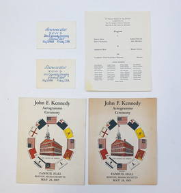
1965 J.F.K. CEREMONY at FANEUIL HALL MATERIALSJohn McInnis Auctioneers,LLC4.6(502)See Sold PriceFeb 25, 2024
Decanters 6 Pieces of cut crystal decanters with stoppers, (3) cut crystal decanters (two stoppersNeely Auction4.6(224)See Sold PriceFeb 25, 2024
Louis XV Style French Marquetry TableEpic Auctions and Estate Sales4.6(204)See Sold PriceMar 02, 2024
Willem Blaeu, Etc. 17th C. Antiquarian Maps, 2Auctions at Showplace4.5(726)See Sold PriceMar 17, 2024
Duval - Pair: Map of Georgia & Map of Moscow, RussiaTrillium Antique Prints & Rare Books4.5(30)See Sold PriceFeb 24, 2024
Duval - Pair: Map of India & Map of MaldivesTrillium Antique Prints & Rare Books4.5(30)See Sold PriceFeb 24, 2024
Antique Map of France, 1703 by Gillaume Del Isle PrintAntiques Online Auctions4.6(407)See Sold PriceMar 14, 2024
Herman Moll A New Map of Ye North Parts of AmericaWillow Auction House4.5(283)See Sold PriceMar 14, 2024


![9 maps, mostly France. Jansson, [ca 1640s-1650s]. (1 of 13)](https://p1.liveauctioneers.com/179/117971/60557771_1_x.jpg?height=282&quality=70&version=1520636872)