SoldAncient Map Collection of 5 Printed 1790-1801This is an Ancient map Collection of 5 unframed maps Printed in London 1790-1801 Map 1) Africa 11" X 9" Map 2) West Indies 13.5" X 9" Map 3) Westphalia 1791 (Europe) 14" X 9" Map 4) Africa (Full ColorSee Sold Price
SoldAncient map Collection of 5 Printed 1790-1801This is an Ancient map Collection of 5 unframed maps Printed in London 1790-1801 Map 1) Denmark 11" X 9" Map 2) France 11" X 9" Map 3) South America 14" X 9" Map 4) Eastern United States 11" X 9" MapSee Sold Price
ANTIQUE CELESTIAL MAPSIZE: 19.5 X 15.5 IN APPROX. UNFRAMED. FOLDED AS ISSUED. PRINTED CIRCA 1812.See Sold Price
Sold1801 Map of GreeceAuthor: Hall Title: 1801 Map of Greece Medium: Ink on Paper Dimensions: 10.5"X8.5" Map of Ancient Greece dated 1801. Part of the Atlas of Ancient Geography by Samuel Butler. Engraved by S. Hall. PubliSee Sold Price
1801 Map of Rome and NaplesAuthor: Hall Title: 1801 Map of Rome and Naples Medium: Ink on Paper Dimensions: 10.5"X8.5" Map of Ancient Italy dated 1801. It captures the Central part of the Peninsula from Rome to Naples. Part ofSee Sold Price
1801 Map of Ancient AsiaAuthor: Hall Title: 1801 Map of Ancient Asia Medium: Ink on Paper Dimensions: 10.5"X8.5" Map of Ancient Asia dated 1801. Part of the Atlas of Ancient Geography. It captures the territory between PersiSee Sold Price
1801 Map of North AfricaAuthor: Hall Title: 1801 Map of North Africa Medium: Ink on Paper Dimensions: 11"X8.5" Map of Ancient Africa dated 1801. Part of the Atlas of Ancient Geography. It captures the North part of the contiSee Sold Price
1801 Map of Ancient AsiaAuthor: Hall Title: 1801 Map of Ancient Asia Medium: Ink on Paper Dimensions: 10.5"X8.5" Map of Ancient Asia dated 1801. Part of the Atlas of Ancient Geography. It captures the territory between PersiSee Sold Price
1801 Map of Ancient AfricaAuthor: Hall Title: 1801 Map of Ancient Africa Medium: Ink on Paper Dimensions: 11"X8.5" Map of Ancient Africa dated 1801. Part of the Atlas of Ancient Geography. It captures the North part of the conSee Sold Price
1801 Map of SpainAuthor: Hall Title: 1801 Map of Spain Medium: Ink on Paper Dimensions: 10.5"X8.5" Map of Ancient Spain dated 1801. Part of the Atlas of Ancient Geography by Samuel Butler. Engraved by S. Hall. PublishSee Sold Price
1801 Map of BritainAuthor: Hall Title: 1801 Map of Britain Medium: Ink on Paper Dimensions: 8.5"X10.5" Map of Ancient Britain dated 1801. Part of the Atlas of Ancient Geography by Samuel Butler. Engraved by S. Hall. PubSee Sold Price
1801 Map of MacedoniaAuthor: Hall Title: 1801 Map of Macedonia Medium: Ink on Paper Dimensions: 10.5"X8.5" Map of Ancient Macedonia dated 1801. Map captures a territory comprised of modern day, Greece, Serbia and RomaniaSee Sold Price
1801 Map of Ancient MacedoniaAuthor: Hall Title: 1801 Map of Ancient Macedonia Medium: Ink on Paper Dimensions: 10.5"X8.5" Map of Ancient Macedonia dated 1801. Map captures a territory comprised of modern day, Greece, Serbia andSee Sold Price
1801 Map of ItalyAuthor: Hall Title: 1801 Map of Italy Medium: Ink on Paper Dimensions: 10.5"X8.5" Map of Ancient Italy dated 1801. It captures the Northern part including the city of Milan Part of the Atlas of AncienSee Sold Price
1801 Map of SicillyAuthor: Hall Title: 1801 Map of Sicilly Medium: Ink on Paper Dimensions: 10.5"X8.5" Map of Ancient Sicilly dated 1801. Part of the Atlas of Ancient Geography by Samuel Butler. Engraved by S. Hall. PubSee Sold Price
1801 Ancient Africa MapAuthor: Hall Title: 1801 Ancient Africa Map Medium: Ink on Paper Dimensions: 11"X8.5" Map of Ancient Africa dated 1801. Part of the Atlas of Ancient Geography. It captures the North part of the continSee Sold Price
Sold1801 Map of SicillyAuthor: Hall Title: 1801 Map of Sicilly Medium: Ink on Paper Dimensions: 10.5"X8.5" Description: Map of Ancient Sicilly dated 1801. Part of the Atlas of Ancient Geography by Samuel Butler. Engraved bySee Sold Price
Sold1801 Map of ItalyAuthor: Hall Title: 1801 Map of Italy Medium: Ink on Paper Dimensions: 10.5"X8.5" Description: Map of Ancient Italy dated 1801. Part of the Atlas of Ancient Geography by Samuel Butler. Engraved by S.See Sold Price
Sold1801 Map of BritainAuthor: Hall Title: 1801 Map of Britain Medium: Ink on Paper Dimensions: 8.5"X10.5" Description: Map of Ancient Britain dated 1801. Part of the Atlas of Ancient Geography by Samuel Butler. Engraved bySee Sold Price
Sold1801 Map of Ancient EgyptAuthor: Hall Title: 1801 Map of Ancient Egypt Medium: Ink on Paper Dimensions: 8.5"X11" Map of Ancient Egypt dated 1801. Part of the Atlas of Ancient Geography. It captures Egypt divided in three partSee Sold Price
Sold1801 Map of the Ancient WorldAuthor: Hall Title: 1801 Map of the Ancient World Medium: Ink on Paper Dimensions: 10.5"X8.5" Map of the ancient World dated 1801. Part of the Atlas of Ancient Geography. Extremely detailed. EngravedSee Sold Price
1801 Map of the Ancient WorldAuthor: Hall Title: 1801 Map of the Ancient World Medium: Ink on Paper Dimensions: 10.5"X8.5" Map of the ancient World dated 1801. Part of the Atlas of Ancient Geography. Extremely detailed. EngravedSee Sold Price
1801 Map of Antique PalestineAuthor: Hall Title: 1801 Map of Antique Palestine Medium: Ink on Paper Dimensions: 8.5"X11" Map of Ancient Palestine dated 1801. Part of the Atlas of Ancient Geography. Engraved by S. Hall. Curated bySee Sold Price
1801 Map of SpainAuthor: Hall Title: 1801 Map of Spain Medium: Ink on Paper Dimensions: 10.5"X8.5" Description: Map of Ancient Spain dated 1801. Part of the Atlas of Ancient Geography by Samuel Butler. Engraved by S.See Sold Price
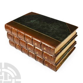
Archaeological Books - Roach Smith - Collectanea Antiqua, etchings and notices of ancient remains,TimeLine Auctions Ltd.4.6(182)See Sold PriceMar 06, 2024
Medieval Printed Paper Bible Page by Johann GrüningerTimeLine Auctions Ltd.4.6(182)See Sold PriceMar 07, 2024
Ancient Roman Imperial Coins - Mixed Billon AR Antoninianus Group [5]TimeLine Auctions Ltd.4.6(182)See Sold PriceMar 09, 2024
Ancient Roman Imperial Coins - Mixed Billon AR Antoninianus Group [5]TimeLine Auctions Ltd.4.6(182)See Sold PriceMar 09, 2024
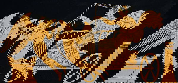
Hamilton - Engraving of a Painting from a Grecian Vase. 5Trillium Antique Prints & Rare Books4.5(30)See Sold PriceFeb 24, 2024
La Basse-Guinée… Loango, Congo, AngoIa & Benguela Southern Africa BONNE 1790 mapJasper524.5(9.8k)See Sold PriceFeb 28, 2024
ANCIENT AFRICA cum Aegypto et Insulis. Nigritae Aethiopia. ARROWSMITH 1828 mapJasper524.5(9.8k)See Sold PriceFeb 28, 2024
États du Roi de Maroc… d’Alger, Tunis & Tripoli. North Africa. BONNE 1790 mapJasper524.5(9.8k)See Sold PriceFeb 28, 2024
Le Canal de Mosambique, l'Isle de Madagascar… Mozambique. Africa. BONNE 1790 mapJasper524.5(9.8k)See Sold PriceFeb 28, 2024
Le Royaume d’Adel… Ajan & Zanguebar. Adal Ajuran. Kenya Tanzania. BONNE 1790 mapJasper524.5(9.8k)See Sold PriceFeb 28, 2024
ANCIENT NORTH AFRICA Septentrionalis. Mauretania Tripolitana ARROWSMITH 1828 mapJasper524.5(9.8k)See Sold PriceFeb 28, 2024
SUB-SAHARAN AFRICA. 'Ancienne Ethiopie'. Ancient Ethiopia. MALLET 1683 old mapJasper524.5(9.8k)See Sold PriceFeb 28, 2024
Afrique Ancienne. Ancient North Africa. MALTE-BRUN c1871 old antique map chartJasper524.5(9.8k)See Sold PriceFeb 28, 2024


![Ancient Roman Imperial Coins - Mixed Billon AR Antoninianus Group [5] (1 of 1)](https://p1.liveauctioneers.com/1191/317894/170617394_1_x.jpg?height=282&quality=70&version=1706620797)
![Ancient Roman Imperial Coins - Mixed Billon AR Antoninianus Group [5] (1 of 1)](https://p1.liveauctioneers.com/1191/317894/170617412_1_x.jpg?height=282&quality=70&version=1706620797)