Sold2 Levasseur maps, Western U.S. and Pacific, 19th cTwo Victor Levasseur maps. Item 1: Steel engraved map of the world with colored borders titled "Planisphere" map by Victor Levasseur, engraved by Raimond Bonheur. Surrounded by an elaborate border witSee Sold Price
Sold19th c. Map of Virginia and Maryland2 19th c. maps of US states 1). Map of Virginia and Maryland with a plan of Washington and Georgetown. 2). Map of Kentucky and Tennessee- both copper engravings, published in London in 1831 by Isaac TSee Sold Price
SoldNEW MAP OF WESTERN TERRITORY OF U.S., BY JOHN CNEW MAP OF WESTERN TERRITORY OF U.S., BY JOHN CARY, 1805, 18" X 19 1/2"See Sold Price
SoldThree (3) 19th C. Maps, Paris, Southern USThree (3) maps, including: 1834 map, Southern US, 17" x 13 1/2", framed 27" x 23", good condition; 1834 map printed Paris, 17" x 13 1/2", framed 27" x 23", good condition; 19th Century dated 1834 PariSee Sold Price
Sold3 19th C. US maps[United States]. 3 Maps. ++ Map Of The Northwest: From Explorations by the United States Engineers & Royal Engineers of England and Union & Northern Pacific R.R. Surveys. Charts northern US and southeSee Sold Price
Sold19TH C MAPS BY ORRIN POTTER U.S. and CONNECTICUTTWO EARLY 19TH C MAPS BY ORRIN POTTER: 1) Map of CONNECTICUT by Orrin Potter, Plymouth 1816, with key showing roads, county lines, court houses, meeting houses, and mountains, 19" x 14 1/2". 2) detailSee Sold Price
Sold(19th c) US / INTERNATIONAL KEEPSAKES REVERE HOUSEIncluding: (2) Banquet menus for Admiral Lessoffsky of the Russian Fleet, Revere House, Boston and Boards of Trade of the Western Cities, Revere House 1864 and 1865 (printed on silk) , gold thread embSee Sold Price
Sold(2) 19th C. Rolled Maps and 19th C. Pocket MapTwo (2) 19th Century rolled maps, fair condition; and 19th Century pocket map of Eastern US with local advertising. Largest 60". Both have wooden rods.See Sold Price
SoldWestern Americana, 19th C. Views, Harpers WeeklyWestern Americana, 19th C. Views, Harpers Weekly prints. "The Far West-Shooting Buffalo On The Line Of The Kansas-Pacific Railroad" and "Pilgrims Of The Plains". Sights 10 1/2" x 15 1/4".See Sold Price
SoldAbout 203 color maps Western states, c.1880-1915[U.S. West]. About 208 maps, mostly from various atlases, all but 5 in printed color, c.1880-1915. About 4 1/2 x 6 5/8 - 12 3/4 x 18 in. Rocky Mountain and West Coast states, Kansas, Nebraska, the DakSee Sold Price
Sold8 color maps: Asia & Africa, 19th C.[Africa]. 8 color maps. ++ 5 from Colton Atlas, c.1855. 14 1/4 x 11 1/8. Includes: 2 titled Africa: North Western Sheet; and 3 titled Africa: North Eastern Sheet. ++ Other 3 from Johnson's Family AtlaSee Sold Price
SoldMAP OF EAST INDIA ARCHIPELAGO, 19th C.Western Route to China, Chart No. 2, 1871 (framed); Published by James Imray & Sons, London; 50 1/4" x 40 1/2" (sight)See Sold Price
Sold19th C. New Rail Road & County Map of N. CarolinaPublished 1878-1883 probably by George F. Cram; depicts cities, towns, rivers and railroads; inset continuation "Western Part of N. Carolina."; 11 1/2"W, 9"H--Private collection, Spartanburg, South CaSee Sold Price
SoldMAPS, Pacific Ocean, U.S. NavyPacific Ocean. U.S. Navy/Andriveau-Goujon, [Lot of 2] Naval Chart of the Pacific and Western Atlantic [and] Oceanie, 1860-1901 (circa). This lot contains two maps focused on colonial ownership in theSee Sold Price
Sold14 Union Pacific Railroad Advertisements, Public Timetable - 1947, Coloring Book, and Mailing14 Union Pacific Railroad advertisements including 2 duplicate Colorado booklets with mild wear and staining on the covers, brochure map of the US, Along the Union Pacific Railroad brochure, Western WSee Sold Price
Sold[Americana - Arctic & Northwest] 2 Congressional[Americana - Arctic & Northwest] 2 Congressional Reports on U.S. Revenue Steamer Corwin - 1880's Cruises in Arctic and Pacific Northwest - Color Plates and Maps Hooper, C.L. REPORT OF THE CRUISE OF THSee Sold Price
SoldMAPS, 2, 19TH C., 12" X 16", CANADA & MICHIGANMAPS, TWO, 19TH C., 12" X 16", CANADA & MICHIGAN:Including 1 engraved by J. & C. Walker, "North America: Sheet V, The North West and Michigan Territories", published by Baldwin & Cradock, 1833, 12 1/2See Sold Price
Sold3 maps: Western US, 2 Mexican War - related.[United States: West]. 3 Maps. ++ James H. Simpson and Edward M. Kern. Map Of The Route Pursued In 1849 By The U.S. Troops, Under the Command of Bvt. Lieut. Col. Jno. M. Washington, Governor [of] NewSee Sold Price
SoldU.S. CIVIL WAR BELTS, BELT BUCKLES, ETC.Three pieces: NCO shoulder belt plate with strap, and (2) "U.S." oval beltbuckles, USA, 19th c. Belt plate diam: 2 1/2"See Sold Price
Sold2 maps: ''Rio Colorado of the West'' 1858, pub. 1[Western US]. 2 Maps. Explorations And Surveys. War Department. Map Nos. 1-2. Rio Colorado Of The West. Drawn by F. W. von Egloffstein. 1858. From: Report Upon The Colorado River Of The West, ExploredSee Sold Price
Sold2 GILT FESTIVAL BONNETS, WESTERN EUROPE, 19TH C1 gold bonnet w/ face-framing brim; 1 metallic silver embroidered cap; very good - excellentSee Sold Price
SoldCOLLECTION OF 4 LATE 19TH C MAPS AND 2 ENGRAVINGSINCLUDING 2 LARGE MAPS OF MIDDLEBOROUGH; 1 OF FREETOWN; 2 OF LAKEVILLE AND 2 ENGRAVINGS OF MIDDLEBOROUGH; SOME STAININGSee Sold Price
Sold5 maps: 19th C., Western Hemisphere, color.[AMERICAS]. 5 Maps. Hand-colored, one in outline. Varying degrees of toning, mostly in and near margins, few small chips at edge, other defects noted. ++ Map of the United States And Territories. TogeSee Sold Price
Sold2 19th c. mapsCartographers: Ferdinand G”tze (attributed), J. Andriveau-Goujon Title: [Map 1, Ferdinand G”tze (attributed)] Charte von Italien [in a set with Map 2, J. Andriveau-Goujon] Carte du Nord-Ouest de LSee Sold Price
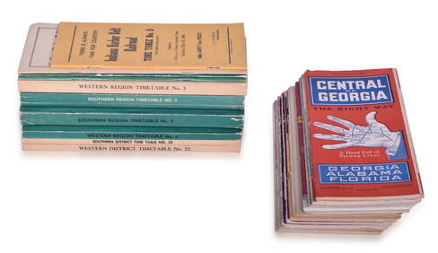
23 Employee and Public Railroad Timetables - NC&StL, NYC, Pennsylvania, C&EI, Southern Pacific, ACL,Rail & Road Auctions4.6(165)See Sold PriceMar 07, 2024
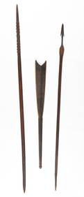
Ethnographic Collector's Lot. Late 19th-Early 20th C.Material Culture4.6(765)See Sold PriceFeb 29, 2024
1675 ELZEVIER JULIUS CAESAR antique ILLUSTRATED w/ MAPS ROMAN HISTORYJasper524.5(9.8k)See Sold PriceFeb 27, 2024
19th C. Orientalist Harem Scene PAINTING O/C by M. K. Gorge L.A.Bidhaus4.3(747)See Sold PriceFeb 26, 2024
19th C. Hermes Intaglio, Athena Cameo, Gold PendantArtemis Fine Arts4.8(1.4k)See Sold PriceFeb 26, 2024
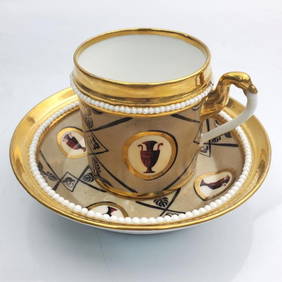
Rare 19th Century Paris Porcelain Cup & SaucerWorld Auction Gallery LLC4.7(261)See Sold PriceMar 10, 2024
Pair of Jeweled Sevres Vase Made into Lamp,19th.CAffinity Antique Auction4.6(248)See Sold PriceMar 03, 2024
19th C. European Figural of Virgin Mary Nursing JesusArtemis Fine Arts4.8(1.4k)See Sold PriceFeb 26, 2024


![[Americana - Arctic & Northwest] 2 Congressional (1 of 6)](https://p1.liveauctioneers.com/46/113409/58240908_1_x.jpg?height=282&quality=70&version=1512492316)