SoldEnglish Ebonized Map Rack, 19th c., on turned suppEnglish Ebonized Map Rack, 19th c., on turned supports, the top sectioned to hold rolled maps, with four Louisiana coastal maps for demonstration purposes, H.- 35 1/2 in., W.- 22 1/2 in., D.- 15 1/2 iSee Sold Price
Sold19th c. Map of Virginia and Maryland2 19th c. maps of US states 1). Map of Virginia and Maryland with a plan of Washington and Georgetown. 2). Map of Kentucky and Tennessee- both copper engravings, published in London in 1831 by Isaac TSee Sold Price
SoldMAPS, 2, 19TH C., 12" X 16", CANADA & MICHIGANMAPS, TWO, 19TH C., 12" X 16", CANADA & MICHIGAN:Including 1 engraved by J. & C. Walker, "North America: Sheet V, The North West and Michigan Territories", published by Baldwin & Cradock, 1833, 12 1/2See Sold Price
Sold19TH C MAPS BY ORRIN POTTER U.S. and CONNECTICUTTWO EARLY 19TH C MAPS BY ORRIN POTTER: 1) Map of CONNECTICUT by Orrin Potter, Plymouth 1816, with key showing roads, county lines, court houses, meeting houses, and mountains, 19" x 14 1/2". 2) detailSee Sold Price
Sold19th c. Map New York City19th c. "Map Of New York And Its Vicinity, New York 1863". Published by S.D. Tildern. 63 1/2" x 63 1/2". Some damage.See Sold Price
SoldGroup of 4 Asian 19th c mapsA group of 4 Asian 19th c maps including colored engraving of China published by George Philip & Son Liverpool 12 1/2" x 10". East India Islands drawn by A Arrowsmith Engraved by S Hall 10" x 8". HindSee Sold Price
Sold19th c. Map19th c. map of New York, H.S. Tanner, hand-colored lithograph. Sight 12 1/2" x 15 1/4".See Sold Price
Sold19th c. Connecticut Map19th c. map "Connecticut From the beft Authorities", marked LRC "Delineated & Engraved by A Doolittle N. Haven". In gilt frame. Sight 14 1/2" x 16 3/4".See Sold Price
SoldFRENCH & AMERICAN PRINTED MAPS 19TH C.-20TH C. 3PCFRENCH & AMERICAN PRINTED MAPS, 19TH C.-20TH C., THREE, H 9 1/4"-14", W 9 1/2"-12 1/2":Including one French map of New Holland, measuring H. 14" x 9 3/4", circa late 19th Century; together with one maSee Sold Price
Sold6 19th c. hand-colored maps of Asia6 19th c. hand-colored maps of Asia- ''Map of Asia Showing Its Political Divisions''; ''Map of Hindoostan, Farther India, China and Tibet''; ''China''; ''Asia'' (2 copies); Russia in Asia and Tartary'See Sold Price
Sold19th c. Wall Map19th c. Dutchess County wall map published in Philadelphia dated 1858. 62" x 59 1/2".See Sold Price
Sold19th C. Souvenir Train Map Tole TrayThis scarce 19th C. Souvenir Train Map Tole Tray measures "15 x 10 1/2."See Sold Price
Sold19TH C. ENGLISH MAHOGANY MAP CHEST19TH C. ENGLISH MAHOGANY MAP CHEST WITH 9 DRAWERS & 2 DOORS & MISMATCHED MARBLE APPROX. 60" W X 58" H X 29" DSee Sold Price
SoldA. Finley, Map of Louisiana, 19th c., hand-colored,A. Finley, Map of Louisiana, 19th c., hand-colored, framed, H.- 9 in., W.- 11 1/2 in.See Sold Price
SoldBooks, Arctic, Middle East, 19th C. includes "TheBooks, Arctic, Middle East, 19th C. includes "The Handwriting of God in Egypt, Sinai and the Holyland, D.A. Randall, 1865 (2 volumes in one), Leather with numerous Maps, Diagrams & Plates; Volume, "WiSee Sold Price
Sold6 UNFRAMED PIECES2 19th C. land prints, 2 19th C. maps, Indiana and Ohio, largest approximately 17 3/8" x 28", "Center Church" print, signed Robert E. Esbensen, numbered 10/23, approximate mat size 20" x 16", and prinSee Sold Price
Sold(2) Late 19th c. maps of Ireland, unframedTwo late 19th century colored maps of Ireland, comprising a map of Ireland printed for The Century Atlas, circa 1897, 16"h x 11"w, unframed, and a map of Ireland printed for The Society for the DiffusSee Sold Price
Sold19TH C. MAP OF PARIS19TH C. MAP OF PARIS: Large framed map of Paris Circa Mid 1900's by Malte-Brun family, in frame. Approx. 35" h x 43" w.See Sold Price
SoldTwo 19th c Maps19th c Atlas page map of Norway - Partie de la Suede et de la Norwege on two sheets plate 22x 19"; 1855 Colton map of Cuba, Jamaica and Puerto Rico 12 x15"See Sold Price
Sold1862 Bowen Civil War Map, Other 19th C. MapsFour 19th c. maps: 1. Framed Bowen's "Map of the Field Operations of the Army of Virginia during the Months of July and August 1862"; report of Maj. Gen. John Pope to the Committee on the Conduct of tSee Sold Price
SoldThree 19th C. Maps & Two 19th C. Prints**Originally Listed At $100** Europe, Ireland and Germany, ca. 19th century CE. A collection of printed materials: two printed German maps, one print of an older engraved map, and two prints of engravSee Sold Price
SoldTwo 19th C. MapsTwo framed 19th C. maps: the United States; Mexico/California/Texas. Various dates and publishers.See Sold Price
SoldMaris Pacifici , 19th C map of the Pacific region ,Maris Pacifici , 19th C map of the Pacific region , after Ortelius Abrahamus. PROVENANCE: Francis de Sales McHugh Collection. 13 x 19in. (33 x 48cm)See Sold Price
2 Early 19Th C. Stools Possibly Shaker, Estate FreshRalph Fontaine Heritage Auctions Inc.4.7(236)See Sold PriceFeb 25, 2024
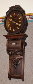
Wonderful 2 Piece 19Th C. Black Forest Barrel Calendar ClockRalph Fontaine Heritage Auctions Inc.4.7(236)See Sold PriceFeb 25, 2024
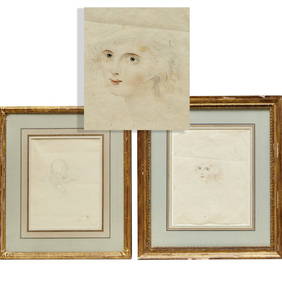
A late 19thC / early 20thC gilt metal stick pin surmounted by a cameo. Approx 3" long. Together withClaydon Auctioneers Ltd4.3(125)See Sold PriceFeb 25, 2024
Map: A 19thC engraved and hand coloured map of South America. Published by the Society for theClaydon Auctioneers Ltd4.3(125)See Sold PriceFeb 26, 2024
Map: A 19thC engraved and hand coloured map of St. Petersburg / Sanktpeterburga by W. B. Clarke.Claydon Auctioneers Ltd4.3(125)See Sold PriceFeb 26, 2024
Map: A 19thC engraved map titled Gloucestershire from the Best Authorities, after John Cary. Approx.Claydon Auctioneers Ltd4.3(125)See Sold PriceFeb 26, 2024
Map: A 19thC engraved and hand coloured map of Buckingham titled A New Map of BuckinghamshireClaydon Auctioneers Ltd4.3(125)See Sold PriceFeb 26, 2024
Map: A 19thC engraved map of West Riding, titled A Map of the North Part of the West Riding ofClaydon Auctioneers Ltd4.3(125)See Sold PriceFeb 26, 2024
2 - 19THC. CHEESE DRAINERS (20 3/4" X 22" WIDE)Carlsen Gallery, Inc.4.6(164)See Sold PriceMar 03, 2024
2 - 19THC. NEW YORK STATE SWING HANDLE BASKETS LARGEST 15 1/2' WIDECarlsen Gallery, Inc.4.6(164)See Sold PriceMar 03, 2024
2- 19THC. SHEFFIELD PLATE TEA CADDIES TALLEST 6" TALLCarlsen Gallery, Inc.4.6(164)See Sold PriceMar 03, 2024
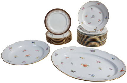
Twenty Four Pieces of Porcelain Dinnerware, 19th c., Platter- H.- 2 7/8 in., W.- 18 7/8 in., D.- 13Crescent City Auction Gallery4.3(231)See Sold PriceMar 08, 2024
Rare 19thc Colton Map, Argentine Republic, Chile, Uruguay, PataguayConnoisseur Auctions3.9(336)See Sold PriceMar 16, 2024
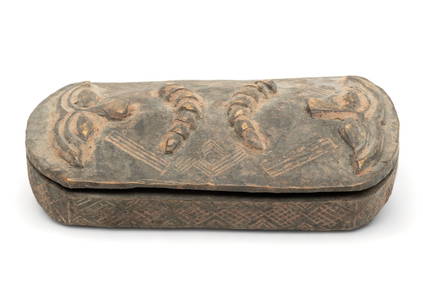
Democratic Republic of Congo, Kuba Peoples, Carved Lidded Box, Ca. 19th C., H 2" W 4.7" L 9.5"DuMouchelles4.6(830)See Sold PriceMar 14, 2024
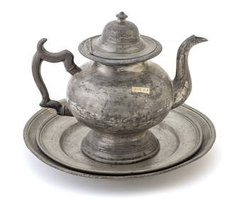
Pewter Plates (2) And Teapot Ca. 19th.c., Dia. 10" 3 pcsDuMouchelles4.6(830)See Sold PriceMar 14, 2024