SoldNEW MAP OF WESTERN TERRITORY OF U.S., BY JOHN CNEW MAP OF WESTERN TERRITORY OF U.S., BY JOHN CARY, 1805, 18" X 19 1/2"See Sold Price
SoldJ. Cary New Map of Part of the USJohn Cary, English, 1754-1835. Hand colored engraved map entitled "A New Map of Part of the United States of America, Exhibiting The Western Territory, Kentucky, Pennsylvania, Maryland, Virginia &c. ASee Sold Price
SoldAN 1811 UNITED STATES MAP BY JOHN CARYA New Map of Part of the United States of North America Exhibiting the Western Territory, Kentucky, Pennsylvania, Maryland, Virginia & c. also the Lakes Superior Michigan Huron Ontario & Erie with UppSee Sold Price
SoldCary: US Western Territory/Great Lakes Region Map, 1805Map: A New Map of Part of the United States of North America, exhibiting the Western Territory, Kentucky, Pennsylvania, Maryland, Virginia &c., also the lakes Superior, Michigan, Huron, Ontario & ErieSee Sold Price
SoldCary Map of the Western Territory, Kentucky,Cary, John (British, 1754-1835). A New Map of Part of the United States of North America, Exhibiting the Western Territory, Kentucky, Pennsylvania, Maryland, Virginia &c. Also, the Lakes Superior, MicSee Sold Price
SoldA New Map... Western Territory, Kentucky...[United States/Old Northwest]. A New Map Of Part Of The United States Of North America, Exhibiting the Western Territory, Kentucky, Pennsylvania, Maryland, Virginia, &c. Also the Lakes Superior, MichiSee Sold Price
New Map of United States of North America, 1805Map: A New Map of Part of the United States of North America, exhibiting the Western Territory, Kentucky, Pennsylvania, Maryland, Virginia &c., also the lakes Superior, Michigan, Huron, Ontario & ErieSee Sold Price
SoldImlay & Filson. New York, 1793IMLAY, Gilbert (c.1754-c.1818) and FILSON, John (c.1747-1788) A Topographical Description of the Western Territory of North America; Containing a Succinct Account of its Climate, Natural History, PoSee Sold Price
SoldUS Map and Book Plate MapUS Map and Book Plate Map. A New Map of Part of the United States by John Cary; c. 1819; Some foxing and toning; 21" x 23". Small Book Plate Map of North America; London: published by G. Virtue; 13" xSee Sold Price
SoldJohn Grigg: Map of Western States & Territories, 1830Map: Western States & Territories Maker: John Grigg, Malte-brun, Conrad/ J. H. Young Date: 1830 Size: Quarto, 9.75 inches high x 8 inches wide From Malte-Brun's "A new General atlas, exhibiting the fiSee Sold Price
SoldMap Group of Eastern US Maps (112207)Single page New jersey c 1920; Massachusetts 1928; Pennsylvania c 1928; New York double truck c 1920s; Ohio/PA double truck,c 1920s, Illinois double truck same date, Indiana double truck, c 1920s. ProSee Sold Price
SoldLands Assigned to Emigrant Indians 1836Title: Map of the Western Territory &c. Author: Hood, Washington Description: Copper-engraved map, hand-colored in outline. 43.5x45.5 cm. (17.18"), folds as issued."Indian" territory, the locations ofSee Sold Price
Sold2 Levasseur maps, Western U.S. and Pacific, 19th cTwo Victor Levasseur maps. Item 1: Steel engraved map of the world with colored borders titled "Planisphere" map by Victor Levasseur, engraved by Raimond Bonheur. Surrounded by an elaborate border witSee Sold Price
SoldHenry Howe HISTORICAL COLLECTIONS OF THE GREAT WESTHenry Howe HISTORICAL COLLECTIONS OF THE GREAT WEST 1857 Decorative Leather Binding Gilt Marbled Page Edges Illustrated India-Tinted Engravings Maps Western US History Frontier Oregon New Mexico TexasSee Sold Price
SoldMitchell Map of Western U.S.*** START PRICE IS THE RESERVE *** [America] MITCHELL, Samuel Augustus (1792-1868). A New Map of Texas, Oregon and California with the Regions Adjoining. Engraving with original hand color, with origiSee Sold Price
Sold3 maps: Western US, 2 Mexican War - related.[United States: West]. 3 Maps. ++ James H. Simpson and Edward M. Kern. Map Of The Route Pursued In 1849 By The U.S. Troops, Under the Command of Bvt. Lieut. Col. Jno. M. Washington, Governor [of] NewSee Sold Price
Sold1805 REGIONAL NORTH AMERICA HAND-COLORED MAP FEAT1805 REGIONAL NORTH AMERICA HAND-COLORED MAP FEATURING VIRGINIA, "A New Map of Part of the United States of North America, Exhibiting The Western Territory, Kentucky, Pennsylvania, Maryland, Virginia,See Sold Price
Sold1869 McNally Map of Western US -- Washington, Oregon,Title: 1869 McNally Map of Western US -- Washington, Oregon, Idaho, Nevada, Utah, and Arizona Date: 1869, New York Cartographer: F McNally Size: 10.8 X 8.5 in. Additional Information: This is a charmiSee Sold Price
SoldFrench Map of Western U.S. c.1870Heading: Author: Andriveau-Goujon Title: Etats-Unis (Etats l'Ouest) Place Published: [Paris] Publisher: Date Published: [c.1870] Description: Engraved map, hand-colored. 62See Sold Price
SoldMap Early 18th Century "A New Map of the World",Most Humbly Inscribed to his Royal Highness George Prince of Wales", by John Senex, c.1721, from the New General Atlas of the World, handcoloured etching, framed, 42cm x 52cmSee Sold Price
1852 Map Railroads US Southern States"Map illustrative of the Internal Improvement System of the South. Prepared by John C. Trautwine Civil Engineer". Map issued for The Journal of the Franklin Institute. Hand colored borders and to charSee Sold Price
SoldMap of the Western Hemisphere, c. 1755Mapsc. 1755 “A New Map of North America,” by Tirion c. 1755 “NIEUWE KAART VAN AMERICA” (A New Map of North America), by Isaac Tirion, Choice Extremely Fine. Handcolored in outlSee Sold Price
SoldGeological Survey of New Jersey Maps, 1868Geological Survey of New Jersey Maps, 1868. Is a series of loose maps of various geological maps throughout New Jersey. By George H Cook & John C Smock, Geologists and surveyed & drawn by G M Hopkins.See Sold Price
LATE 17TH C. FRENCH MAP OF THE NEW WORLD BY ALEXIS-HUBERT JAILLOT (1632-1712)Thomaston Place Auction Galleries4.4(394)See Sold PriceFeb 24, 2024
GROUPING OF (19th c) BRITISH SATIRICAL PRINTS etcJohn McInnis Auctioneers,LLC4.5(505)See Sold PriceFeb 24, 2024
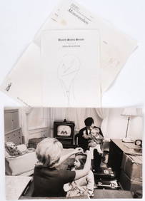
LIFE MAGAZINE UNPUBLISHED TED KENNEDY PHOTOGRAPHJohn McInnis Auctioneers,LLC4.5(505)See Sold PriceFeb 25, 2024
John C Forbes (Canada,1846-1925) oil painting antiqueBroward Auction Gallery4.7(300)See Sold PriceApr 14, 2024
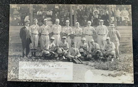
1912 Mint RPPC Postcard Dexter Folder Co. Baseball Team on FieldMynt Auctions4.6(711)See Sold PriceFeb 24, 2024
Map: A 19thC engraved and hand coloured map of Buckingham titled A New Map of BuckinghamshireClaydon Auctioneers Ltd4.3(125)See Sold PriceFeb 26, 2024
Coin Silver by John Knepfly of New Albany, In Teaspoon C. 1845-80 6"Mynt Auctions4.6(711)See Sold PriceFeb 29, 2024
West Indies Islands. Guadaloupe. | Mariegalante &C. | Antigua.Jasper524.5(9.9k)See Sold PriceFeb 27, 2024
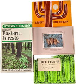
4 Ecology Of Eastern Forest & Tree Finder PaperbacksRapid Estate Liquidators and Auction Gallery4.5(1.1k)See Sold PriceFeb 25, 2024
James C Magee (PA,NY,1846-1924) oil paintingBroward Auction Gallery4.7(300)See Sold PriceMay 19, 2024


![[Ambrotype] Identified Tennessee Soldier (1 of 3)](https://p1.liveauctioneers.com/7226/317626/170485496_1_x.jpg?height=282&quality=70&version=1706368022)