Sold19th c. Map of Virginia and Maryland2 19th c. maps of US states 1). Map of Virginia and Maryland with a plan of Washington and Georgetown. 2). Map of Kentucky and Tennessee- both copper engravings, published in London in 1831 by Isaac TSee Sold Price
Sold6 UNFRAMED PIECES2 19th C. land prints, 2 19th C. maps, Indiana and Ohio, largest approximately 17 3/8" x 28", "Center Church" print, signed Robert E. Esbensen, numbered 10/23, approximate mat size 20" x 16", and prinSee Sold Price
Sold(2) Late 19th c. maps of Ireland, unframedTwo late 19th century colored maps of Ireland, comprising a map of Ireland printed for The Century Atlas, circa 1897, 16"h x 11"w, unframed, and a map of Ireland printed for The Society for the DiffusSee Sold Price
SoldMAPS, 2, 19TH C., 12" X 16", CANADA & MICHIGANMAPS, TWO, 19TH C., 12" X 16", CANADA & MICHIGAN:Including 1 engraved by J. & C. Walker, "North America: Sheet V, The North West and Michigan Territories", published by Baldwin & Cradock, 1833, 12 1/2See Sold Price
SoldCOLLECTION OF 4 LATE 19TH C MAPS AND 2 ENGRAVINGSINCLUDING 2 LARGE MAPS OF MIDDLEBOROUGH; 1 OF FREETOWN; 2 OF LAKEVILLE AND 2 ENGRAVINGS OF MIDDLEBOROUGH; SOME STAININGSee Sold Price
Sold(4) 19th c. Maps and Guides to New York CityIncluding (2) "'The Great Metropolis or New York in 945" by John Dogget. New York. Hardcover mottled cloth-bound, gilt and blind stamped. (fading, minor wear to covers, toning) 5 1/2 x 3 1/2 inches eaSee Sold Price
Sold(16) 19TH C. MAPS OF THE WEST INDIES IN FOLIO,Including: "L'Isle de Ste. Domingue, et celle de Porto Rico", by Bonne, hand colored engraving,1778, 10" x 14 1/2"; PLUS "West Indies", Smith's Atlas, 1808, hand colored engraving, 1808, 11" x 14"; PLSee Sold Price
Sold19th c. Map New York City19th c. "Map Of New York And Its Vicinity, New York 1863". Published by S.D. Tildern. 63 1/2" x 63 1/2". Some damage.See Sold Price
Sold19th C. Map of North & South CarolinaEach county individually hand colored; unframed; 14 1/2"W, 12"H; small tears to margins well outside border and map, toningSee Sold Price
UNFRAMED 19TH C. MAP OF IRELANDHand Colored Engraving, maker unknown, unframed, 17" x 14" sheet, 12" x 9 1/2" image, shrinkwrapped. Toned, margin indentation, edge tears and bends (would mat out).See Sold Price
Sold19th C. Map of Marblehead, MAMap of Marblehead, MA, lithograph, dated 1850, published by Henry McIntyre, 35 1/2" h x 27 3/4" w (view), 38 5/8" h x 30 7/8" w (frame). Provenance: MA estate.See Sold Price
Sold19th C. Map of Marblehead, MAMap of Marblehead, MA, lithograph, dated 1850, published by Henry McIntyre, 35 1/2" h x 27 3/4" w (view), 38 5/8" h x 30 7/8" w (frame). Provenance: MA estate.See Sold Price
SoldJOSEPH T. SCOTT (AMERICAN, 18TH/19TH C.) MAP OFJOSEPH T. SCOTT (AMERICAN, 18TH/19TH C.) MAP OF VIRGINIA, on laid paper, titled "VIRGINIA" in upper left corner, above scale; printed for "The New and Universal Gazetteer". Late 18th century. 7 1/2" xSee Sold Price
Sold19th c. Connecticut Map19th c. map "Connecticut From the beft Authorities", marked LRC "Delineated & Engraved by A Doolittle N. Haven". In gilt frame. Sight 14 1/2" x 16 3/4".See Sold Price
SoldFrame LotFrame lot including print Vue de la Ville et du Port de Bordeaux" (sight 23 1/2" x 33"), map "Paris Sous Francois" (sight 12" x 16 1/2"), 19th c. print: Opening Of London Bridge Aug. 1, 1831 After J.See Sold Price
SoldAssembled Collection of 13 19th C Atlas MapsDESCRIPTION: Assembled collection of 13 atlas maps. Includes: 1) View of Calcutta published in 1842 by Chapman & Hall. 2) Circa 1840 views of Syracuse, Parma, London, and Ireland. Published by The SocSee Sold Price
Sold6 19th c. hand-colored maps of Asia6 19th c. hand-colored maps of Asia- ''Map of Asia Showing Its Political Divisions''; ''Map of Hindoostan, Farther India, China and Tibet''; ''China''; ''Asia'' (2 copies); Russia in Asia and Tartary'See Sold Price
Sold3 19th c. American Map BooksThree 19th century American books. 1ST ITEM: 2 Volume set of The History and Topography of the United States, edited by John Howard Hinton, published London by Simpkin & Marshall &Thomas Waddle, PhilaSee Sold Price
Sold19th c. Wall Map19th c. Dutchess County wall map published in Philadelphia dated 1858. 62" x 59 1/2".See Sold Price
Sold2 Antique 19thC. Leather Family Bibles 1825Lot of two antique Bibles. With ornate gold embossed details on spine, gorgeous marbled endpapers. Marked Family Bibles of previous owners. Includes maps, charts, and etchings. Publisher: BrattleboroSee Sold Price
SoldThree 19th Century Celestial MapsThree 19th C. celestial maps, framed under glass. Two dated 1835, the other 1832. Published by F.J. Huntington, Connecticut. Sheets measure: 15" x 13-1/2".See Sold Price
SoldTexas nach den Besten Quellen Map, 19th CMap: Texas nach den Besten Quellen Cartographer: Bibliographischen Instituts. / Radefeld Place & Date: Hildburghausen / 1849/1857 Size: 13 7/8" x 11 1/2" Condition: original outline color The scarce sSee Sold Price
SoldLATE 19TH C. STUDENT DRAWN MAP OF NEW BEDFORD, MASS"A Picture Map of New Bedford", graphite and colored pencil on muslin, with handwritten captions, in fatigued panel frame under old glass, OS: 13 3/4" x 11 1/2", SS: 11" x 14 3/4". Creased, stained.See Sold Price
CHINESE EXPORT PORCELAIN BOWLS WITH PEACOCKSThomaston Place Auction Galleries4.4(386)See Sold PriceFeb 24, 2024
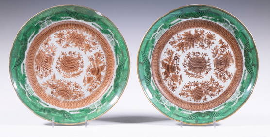
CHINESE BROWN AND GREEN FITZHUGH PORCELAIN PLATESThomaston Place Auction Galleries4.4(386)See Sold PriceFeb 24, 2024
19thc Colton Map, Comparitive Size of Lakes & IslandsConnoisseur Auctions4(333)See Sold PriceFeb 24, 2024
2 Early 19Th C. Stools Possibly Shaker, Estate FreshRalph Fontaine Heritage Auctions Inc.4.7(235)See Sold PriceFeb 25, 2024
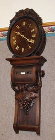
Wonderful 2 Piece 19Th C. Black Forest Barrel Calendar ClockRalph Fontaine Heritage Auctions Inc.4.7(235)See Sold PriceFeb 25, 2024
Map: A 19thC engraved and hand coloured map of South America. Published by the Society for theClaydon Auctioneers Ltd4.3(125)See Sold PriceFeb 26, 2024
Map: A 19thC engraved map titled Gloucestershire from the Best Authorities, after John Cary. Approx.Claydon Auctioneers Ltd4.3(125)See Sold PriceFeb 26, 2024
1816 MAP SOUTHERN PART OF RUSSIA or MUSCOVY in EUROPE copper engraving ANTIQUEJasper524.5(9.8k)See Sold PriceFeb 27, 2024
1744 ROMAN HISTORY ARMORIAL VELLUM BINDING ILLUSTRATED w/ MAP antique by FLORUSJasper524.5(9.8k)See Sold PriceFeb 27, 2024
1816 MAP NORTHERN PART OF RUSSIA or MUSCOVY in EUROPE copper engraving ANTIQUEJasper524.5(9.8k)See Sold PriceFeb 27, 2024
1758 MAP PARTIE DE LA MER GLACIALE contenants La Nouvelle Zemble RUSSIA antiqueJasper524.5(9.8k)See Sold PriceFeb 27, 2024
1675 ELZEVIER JULIUS CAESAR antique ILLUSTRATED w/ MAPS ROMAN HISTORYJasper524.5(9.8k)See Sold PriceFeb 27, 2024
2 - 19THC. CHEESE DRAINERS (20 3/4" X 22" WIDE)Carlsen Gallery, Inc.4.6(163)See Sold PriceMar 03, 2024
2 - 19THC. NEW YORK STATE SWING HANDLE BASKETS LARGEST 15 1/2' WIDECarlsen Gallery, Inc.4.6(163)See Sold PriceMar 03, 2024
2- 19THC. SHEFFIELD PLATE TEA CADDIES TALLEST 6" TALLCarlsen Gallery, Inc.4.6(163)See Sold PriceMar 03, 2024
Group of 2 19thC Export Painting Hanging ScrollsStunning Arts Auction & Appraisal 4.6(75)See Sold PriceMar 09, 2024