ATLAS of ANTIENT GEOGRAPHY by SAMUEL BUTLER 1843John McInnis Auctioneers,LLC4.6(504)See Sold PriceFeb 24, 2024
18TH C. ANTIQUE MAP: FRENCH & INDIAN WAR, FRAMEDThomaston Place Auction Galleries4.4(389)See Sold PriceFeb 24, 2024
Rand McNally Railroad Map Cabinet w/ 21 Railroad MapsRail & Road Auctions4.6(165)See Sold PriceMar 08, 2024
Keith Haring - Ink on New York Map, Best Buddies, Inscribed, Signed, and DatedSapphire Auction Gallery4.1(67)See Sold PriceMar 02, 2024
LATE 17TH C. FRENCH MAP OF THE NEW WORLD BY ALEXIS-HUBERT JAILLOT (1632-1712)Thomaston Place Auction Galleries4.4(389)See Sold PriceFeb 24, 2024
Central Railroad of New Jersey Map of Sandy Hook Route-ca. 1903JM Hobby Supply and Railroad Artifact Auctions4.4(126)See Sold PriceFeb 24, 2024
Lot of Six Mixed Atlas Box Cars-HO Scale-New in BoxJM Hobby Supply and Railroad Artifact Auctions4.4(126)See Sold PriceFeb 25, 2024
Rand McNally/Santa Fe Railroad Map of Iowa-1912JM Hobby Supply and Railroad Artifact Auctions4.4(126)See Sold PriceFeb 24, 2024
NICOLAES VISSCHER (NETHERLANDS, 1618-1709) MAP OF THE NEW WORLDThomaston Place Auction Galleries4.4(389)See Sold PriceFeb 24, 2024
17TH C. WORLD MAP BY NICOLAES VISSCHER (NETHERLANDS, 1618-1709)Thomaston Place Auction Galleries4.4(389)See Sold PriceFeb 24, 2024
Lot of Six Mixed Atlas Cabooses-HO Scale-New in BoxJM Hobby Supply and Railroad Artifact Auctions4.4(126)See Sold PriceFeb 25, 2024
Sold(2) 17TH C. MAPS OF HOLLANDBoth hand colored engravings, specific areas of Holland Dimensions: (largest open) H 20.5" x W 24" Condition: Some edge damages, losses, small spots of stainingSee Sold Price
SoldEight Antique Maps by BlaeuEight Antique Maps by Blaeu , 17th c., hand-colored engravings, incl. Holland, Frankfort, Austria, Umbria, and others, sheets 19 1/2 in. x 23 in Provenance: Property deaccessioned from the Louisiana SSee Sold Price
Sold2 - 17THC. FRAMED MAPS OF BERMUDA, ONE BY W. BLAEU 1640 & 1 BY JANSSONIUS JOANNES (19" X 23 3/4")2 - 17THC. FRAMED MAPS OF BERMUDA, ONE BY W. BLAEU 1640 & 1 BY JANSSONIUS JOANNES (19" X 23 3/4")See Sold Price
Sold2 SMALL MATTED 17TH C. MAPS, ASIA,BY CLUVER, NICE 5" X 5" AND AFRICA BY PHILLIP CLUVER, 5" X 5"See Sold Price
SoldEARLY MAP "INSULA CANDIA EJUSQUE FORTIFICATIO",FREDRICK DE WIT, 18" X 21 1/2", POSSIBLY 17TH C. THIS MAP OF THE ISLAND OF CRETE SHOWING THE ISLAND FOLLOWING THE SIEGE OF CANDIA, 24 YEAR CONFLICT IN WHICH THE OTTOMANS BESIEGED THIS VENETIAN RULED CSee Sold Price
Sold17th c. Map of Ireland17th c. Map of Ireland by William Hole- ''Hiberniae Anglis, Yuerdon Britannis Erin incolis, Ierna, London, later hand-coloring, paper age toned. 11 x 13 1/2''See Sold Price
Sold17th c. Map17th c. map of Great Britain, "LE ROYAUME D' ANGLETERRE...". Loose in frame and not glued down. Sight 32" x 23 1/2". Marked and dated "A Paris chez H. Laillot 1693".See Sold Price
Soldfour small 17th c maps of parts of Africafour small 17th c maps of parts of Africa, largest 5 1/2" x 7 1/4"See Sold Price
SoldJohn Speed 17th C Map Europe And The Chief CitiesJohn Speed (English, c.1551–1629). A hand colored 17th century map of Europe titled EUROP, AND THE CHIEFE CITIES, featuring description on verso. Measures 16 in. x 21 in. (sight), 20 1/2 in. x 25 1/See Sold Price
SoldFantastic Dutch 17th C. map of Japan & adjacent islandsA nice Dutch map of Japan and adjacent islands by Joan Jansson, c. 1660. Title: New and Accurate Japan, Land of Ezo and Adjacent Islands, fully hand-colored with 2 Compass Roses, 4 Galleons and a SeaSee Sold Price
Sold17th C. Map of Germany17th century, map of Germany, hand-colored, original frame, 19 7/8"h x 23 1/2"w (view), 27 5/8"h x 31"w (frame).See Sold Price
SoldLate 16th / Early 17thc Map of South East England,Gerard Mercator ( 1565 - 1656 ) engraved map of "South East England". With Latin text to the reverse, in modern Hogarth frame with glass to both sides.14 1/2" X 18 1/2". Provenance : R. Deverall, DuvaSee Sold Price
Sold17THC. MAP OF NORTH AMERICACARTOGRAPHER UNKNOWN, POSS. JAN JANSSON 21 1/2" X 18 1/4"See Sold Price
Sold(2) Delft blue and white tobacco jars(2) Delft blue and white tobacco jars, 17th/18th c., Holland, one labeled "Rappe" and decorated with feather-skirted Indians smoking pipes, the other labeled "Schotse" with foliate and scroll decoratiSee Sold Price
SoldFRAMED 17TH C. DUTCH MAP BY JOAN BLAEU (1596-1673)"Territorii Bergensis Accvratissima Descriptio", from "Atlas Maior Sive Cosmographia Blaviana, Qua Solvm, Salvm, Coelvm, Accvratissime Describvntvr." Koeman B1 56; van der Krogt 2:601-3 (first volumeSee Sold Price
Sold17th C. Partial Map of Europe by H. van LoonH. van Loon, circa 1685, framed map of Turkey, "Arabia", and "Persia", 18 3/4" x 25" sight, 20 1/4" x 26 1/2" framed.See Sold Price
Sold19TH C. RE-STRIKE OF 17TH C. HONDIUS MAP OF THE WORLD"Nova Totius Terrarum Orbis Geographica ac Hydrographica Tabula, auct. Ind. Hondio.", a Paris, Chez Nicolas Bercy, 1649. Hand colored engraving, in stick frame, no glass. OS: 20 1/2" x 26 3/4", imageSee Sold Price
Sold17thC. Hand-colored Map FLANDRIA ET ZELANDIA COMITATUSFlanders Flandria Zeelandia c.1640 Belgium & Holland engraved hand colour map Flandria et Zelandia Comitatus [Flanders and Zeelandia County] Issued c.1640, by Matthäus Merian der Ältere (or "MaSee Sold Price
SoldAntique Bone figure of Christ Corpus Christi HollandAntique Bone figure of Christ Corpus Christi Holland c.17th cent AD. size 3 1/2 inch length. Carved bone figure of Christ, from a crucifix, wearing a tunic tied at his waist and the crown of Thorns, nSee Sold Price
Sold2 Antique Maps, c. 1600, Florence & YorkshireTwo Antique Handcolored Maps, c. 1600, Florence by Don Stephano, late 16th c. & Yorkshire by John Speed, early 17th c. {ACGQ7041/2} (TC ) Dimensions: Florence 13.5 x 18.5, framed 20x25; the YorkshireSee Sold Price
SoldFrance Antique Map & View, 17th C.Descriptio Veromanduorum, Antique map, Blaeu, Amsterdam, mid 17th C. W/ view Mommedy on 2 separate sheets, engraving by Israel Silvestre, 1669. 19 1/2" x 26 1/4".See Sold Price
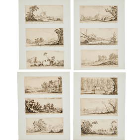
SoldEphemera LotEphemera Lot including (2) early constellation maps (21 x 27 1/2") believed to be 17th c. and reproductions of "Constellations of the Cellarius Atlas", Hansen Planetarium editions (as found), JapaneseSee Sold Price
SoldNine Antique Maps of EuropeNine Antique Maps of Europe , 17th c., by Mercator and Jansson, hand-colored engravings, sheets 19 1/2 in. x 23 in Provenance: Property deaccessioned from the Louisiana State Museum, proceeds to be usSee Sold Price
17TH C. WORLD MAP BY NICOLAES VISSCHER (NETHERLANDS, 1618-1709)Thomaston Place Auction Galleries4.4(389)See Sold PriceFeb 24, 2024
LATE 17TH C. FRENCH MAP OF THE NEW WORLD BY ALEXIS-HUBERT JAILLOT (1632-1712)Thomaston Place Auction Galleries4.4(389)See Sold PriceFeb 24, 2024
17TH C. ENGLISH CHART OF THE THAMES BY CAPT. GREENVILLE COLLINS, 1693-4, FRAMEDThomaston Place Auction Galleries4.4(389)See Sold PriceFeb 24, 2024
17TH C. ANTIQUE MAP SIEGE OF LA ROCHELLE, FRANCE, FRAMEDThomaston Place Auction Galleries4.4(389)See Sold PriceFeb 24, 2024
17TH C. MAP OF THE BERKSHIRES BY JOHN SPEED, FRAMEDThomaston Place Auction Galleries4.4(389)See Sold PriceFeb 24, 2024
17TH C. ENGLISH LINEAR MAP BY OGILBY, FRAMEDThomaston Place Auction Galleries4.4(389)See Sold PriceFeb 24, 2024
17TH C. DUTCH EARLY DELFTWARE BASINThomaston Place Auction Galleries4.4(389)See Sold PriceFeb 24, 2024
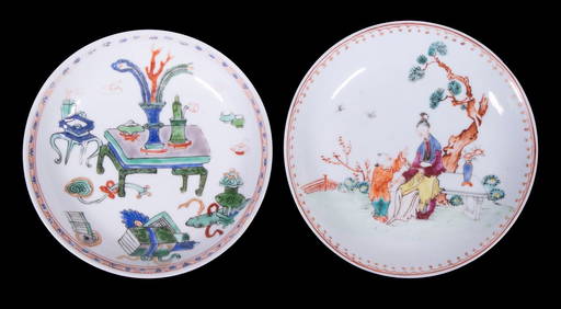
CHINESE KANGXI PERIOD PORCELAIN SAUCERSThomaston Place Auction Galleries4.4(389)See Sold PriceFeb 24, 2024
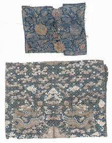
2 Antique Chinese Textile Fragments, 17th C. and 19th C.Material Culture4.6(769)See Sold PriceFeb 29, 2024
Willem Blaeu, Etc. 17th C. Antiquarian Maps, 2Auctions at Showplace4.6(731)See Sold PriceMar 17, 2024
Two (2) Antique 18th C. Copper Engraved Framed Maps - America & EuropeMagnusson Art Group4.5(50)See Sold PriceMar 14, 2024
Map: A 17thC engraved and hand coloured map of Scotland titled Strath-Navernia / Strath Navern afterClaydon Auctioneers Ltd4.3(125)See Sold PriceFeb 26, 2024
Map: A 17thC engraved map of the British Isles titled A Generall Mapp of the Isles of GreatClaydon Auctioneers Ltd4.3(125)See Sold PriceFeb 26, 2024
Map: A 17thC engraved and hand coloured map of Bedfordshire after Robert Morden. Approx. 12 1/2" xClaydon Auctioneers Ltd4.3(125)See Sold PriceFeb 26, 2024
Map: A 17thC engraved and hand coloured map after Frederik de Wit (1630-1706) titled Nova Persiae,Claydon Auctioneers Ltd4.3(125)See Sold PriceFeb 26, 2024
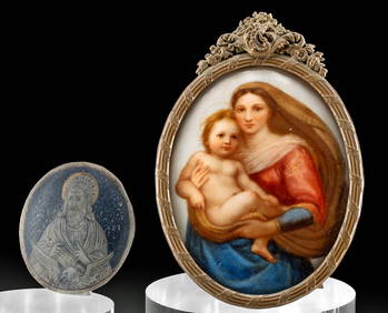
17th C. Niello Plaque + 19th C. Porcelain PaintingArtemis Fine Arts4.8(1.4k)See Sold PriceFeb 26, 2024