ATLAS of ANTIENT GEOGRAPHY by SAMUEL BUTLER 1843John McInnis Auctioneers,LLC4.5(505)See Sold PriceFeb 24, 2024
18TH C. ANTIQUE MAP: FRENCH & INDIAN WAR, FRAMEDThomaston Place Auction Galleries4.4(393)See Sold PriceFeb 24, 2024
Rand McNally Railroad Map Cabinet w/ 21 Railroad MapsRail & Road Auctions4.6(165)See Sold PriceMar 08, 2024
Keith Haring - Ink on New York Map, Best Buddies, Inscribed, Signed, and DatedSapphire Auction Gallery4(67)See Sold PriceMar 02, 2024
LATE 17TH C. FRENCH MAP OF THE NEW WORLD BY ALEXIS-HUBERT JAILLOT (1632-1712)Thomaston Place Auction Galleries4.4(393)See Sold PriceFeb 24, 2024
Central Railroad of New Jersey Map of Sandy Hook Route-ca. 1903JM Hobby Supply and Railroad Artifact Auctions4.4(127)See Sold PriceFeb 24, 2024
Lot of Six Mixed Atlas Box Cars-HO Scale-New in BoxJM Hobby Supply and Railroad Artifact Auctions4.4(127)See Sold PriceFeb 25, 2024
Rand McNally/Santa Fe Railroad Map of Iowa-1912JM Hobby Supply and Railroad Artifact Auctions4.4(127)See Sold PriceFeb 24, 2024
NICOLAES VISSCHER (NETHERLANDS, 1618-1709) MAP OF THE NEW WORLDThomaston Place Auction Galleries4.4(393)See Sold PriceFeb 24, 2024
17TH C. WORLD MAP BY NICOLAES VISSCHER (NETHERLANDS, 1618-1709)Thomaston Place Auction Galleries4.4(393)See Sold PriceFeb 24, 2024
Lot of Six Mixed Atlas Cabooses-HO Scale-New in BoxJM Hobby Supply and Railroad Artifact Auctions4.4(127)See Sold PriceFeb 25, 2024
Sold19thc Map of New Netherland, 17thc Dutch Colony1879 bookplate print, wood engraving, map of New Netherland ( 17thc Dutch Colony ) after an original 1656 map of A. Vanderdonck. 6" X 9 1/2" page size. 4 1/4" X 7" map size. New Netherland was comSee Sold Price
SoldEARLY DUTCH MAP NEW ENGLAND NOVA BELGICA 1635This Dutch colored map of New Netherland and New England derives from Adriaen Block’s 1614 hand-drawn chart. The chart defined Manhattan and Long Island as islands after Block's explorationsSee Sold Price
SoldPETER STUYVESANT(1612 – 1672) Dutch Director-General of the colony of New Netherland from 1647 until it was ceded to the English in 1664, after which it was renamed New York. A major figure in the early history ofSee Sold Price
SoldPeter StuyvesantLast Dutch Director-General of the colony of New Netherland (1612–1672) who was a major figure in the early history of New York City. Incredibly rare LS in Dutch, signed “P. Stuyvesant,” one pagSee Sold Price
SoldJames Hardie THE DESCRIPTION OF THE CITY OF NEW-YORKJames Hardie THE DESCRIPTION OF THE CITY OF NEW-YORK 1827 Leatherbound Hand-Colored Fold-Out Map S Marks Discovery of America Dutch Colony Negro Plot Sir Charles Hardie Evacuation British Census PubliSee Sold Price
Rare Antique Classroom Pull Down Map RackLate 19th -Early 20th Century.Denoyer - Geppert Co. Chicago.1) Third and Last Algonkin Period Map.2)New Netherland Map.3)Political and Conservation Map.4)Formation Of The State(New York) Map.5)City GoSee Sold Price
SoldFramed Map of New NetherlandNew Netherland map, framed, Nova Belgica et Anglia Nova, fort, animal and Indians in canoes, color accents, French text on verso, matted and framed, 22" x 27". Willem Blaeu, Amsterdam 1635 CONDITION:See Sold Price
The Dutch colony of the Cape of Good Hope. South AfricaTITLE/CONTENT OF MAP: 'The Dutch colony of the Cape of Good Hope by L.S. De La Rochette' The top image on the right hand side shows the entire map. To view a close up of the map showing the level of pSee Sold Price
The Dutch colony of the Cape of Good Hope. South AfricaTITLE/CONTENT OF MAP: 'The Dutch colony of the Cape of Good Hope by L.S. De La Rochette' The top image on the right hand side shows the entire map. To view a close up of the map showing the level of pSee Sold Price
Rare Antique Classroom Pull Down Map RackLate 19th -Early 20th Century.Denoyer - Geppert Co. Chicago. 1) Third and Last Algonkin Period Map. 2)New Netherland Map. 3)Political and Conservation Map.See Sold Price
The Dutch colony of the Cape of Good Hope. South AfricaTITLE/CONTENT OF MAP: 'The Dutch colony of the Cape of Good Hope by L.S. De La Rochette' The top image on the right hand side shows the entire map. To view a close up of the map showing the level of pSee Sold Price
SoldDOCUMENTS NEW NETHERLAND Early NYC Dutch 1924We at CNY Book Auctions are pleased to offer a large selection of works on early United States History and Explorations, Civil War History, Slavery, and U.K. Histories, including English, Irish, and SSee Sold Price
SoldEarly 19thC Map of Late 17thC Scenes, DieppeEarly 19th century map of late 17th century scenes, Dieppe, France, 21" x 30", frame 29" x 39".See Sold Price
SoldEarly 19thC Map of Late 17thC Scenes, RouenEarly 19th century map of late 17th century scenes, Rouen, France, 25" x 20", frame 33" x 29".See Sold Price
19thc Colton Map of New Brunswick, Nova Scotia,1857 Colton Map of New Brunswick, Nova Scotia, Newfoundland & Prince Edward Island. Antique geographical map. From the famous "Colton's General atlas" by Colton ( NYC J.H. Colton And Company, No. 172See Sold Price
SoldScarce Hudson-Fulton Celebration TapestryA woven tapestry with the Roman numerals for 1626 at center top for the year Manhatten was purchased from the Native Americans by the Dutch, and showing map of the Dutch colony in North America entitlSee Sold Price
A 19thc Map of Quebec Inc. New York & New EnglandAn exact map of the province of Quebec with part of New York and New England from the latest surveys, signed to the bottom J. Lodge Sculpture, map measures 9" H x 11" W, nicely framed and matted.See Sold Price
A 19thc Map of Quebec Inc. New York & New EnglandAn exact map of the province of Quebec with part of New York and New England from the latest surveys, signed to the bottom J. Lodge Sculpture, map measures 9" H x 11" W, nicely framed and matted.See Sold Price
SoldA 19thc Map of Quebec Inc. New York & New EnglandAn exact map of the province of Quebec with part of New York and New England from the latest surveys, signed to the bottom J. Lodge Sculpture, map measures 9" H x 11" W, nicely framed and matted.See Sold Price
SoldA 19thc Map of Quebec Inc. New York & New EnglandAn exact map of the province of Quebec with part of New York and New England from the latest surveys, signed to the bottom J. Lodge Sculpture, map measures 9" H x 11" W, nicely framed and matted.See Sold Price
A 19thc Map of Quebec Inc. New York & New EnglandAn exact map of the province of Quebec with part of New York and New England from the latest surveys, signed to the bottom J. Lodge Sculpture, map measures 9" H x 11" W, nicely framed and matted.See Sold Price
A 19thc Map of Quebec Inc. New York & New EnglandAn exact map of the province of Quebec with part of New York and New England from the latest surveys, signed to the bottom J. Lodge Sculpture, map measures 9" H x 11" W, nicely framed and matted.See Sold Price
SoldA 19thc Map of Quebec Inc. New York & New EnglandAn exact map of the province of Quebec with part of New York and New England from the latest surveys, signed to the bottom J. Lodge Sculpture, map measures 9" H x 11" W, nicely framed and matted.See Sold Price
SoldMap: A 19thC engraved map of Australia, New Zealand andMap: A 19thC engraved map of Australia, New Zealand and East India Islands, engraved and published by G. F. Crutchley. Approx. 15 1/2" x 18 1/2"See Sold Price
PETRUS LANGENDULT New Testament Commentary c1687 Full Calf Dutch AmsterdamLuis Porretta Fine Arts4.3(10)See Sold PriceMar 02, 2024
LARGE LATE 17TH C. DUTCH CHART OF CANADA, GREAT LAKES, NEW FRANCE, LABRADOR, HUDSON BAY, BY PIERREThomaston Place Auction Galleries4.4(393)See Sold PriceFeb 24, 2024
EARLY 18TH C. DUTCH CHART OF PACIFIC OCEAN BY FREDERIK DE WIT (1629-1706) WITH CALIFORNIA AS ANThomaston Place Auction Galleries4.4(393)See Sold PriceFeb 24, 2024
19thc Colton Map, Comparitive Size of Lakes & IslandsConnoisseur Auctions3.9(336)See Sold PriceFeb 24, 2024
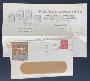
1920 Troy NY USA Advertising Cover Dutch Colony Coffee With LetterMynt Auctions4.6(697)See Sold PriceFeb 26, 2024
Willem Blaeu, Etc. 17th C. Antiquarian Maps, 2Auctions at Showplace4.6(740)See Sold PriceMar 17, 2024
Map: A 19thC engraved and hand coloured map of Buckingham titled A New Map of BuckinghamshireClaydon Auctioneers Ltd4.3(125)See Sold PriceFeb 26, 2024
1738 BIBLE in DUTCH ILLUSTRATED w/ MAPS MASSIVE FOLIO in DUTCH antique BIBLIAJasper524.5(9.9k)See Sold PriceFeb 27, 2024
1738 BIBLE in DUTCH ILLUSTRATED w/ MAPS antique MASSIVE FOLIO BIBLIAJasper524.5(9.9k)See Sold PriceFeb 27, 2024
1772 GREEK BIBLE NEW TESTAMENT antique BIBLIA LATIN text MAP NOVUM TESTAMENTUMJasper524.5(9.9k)See Sold PriceFeb 27, 2024
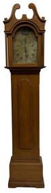
19THC. NEW ENGLAND TALL CASE CLOCK, WORKING ORIGINAL PAINTED DIAL 87" TALL X 19 1/2" WIDE X 11 1/2"Carlsen Gallery, Inc.4.6(164)See Sold PriceMar 03, 2024
3 - 19THC. NEW YORK STATE BASKETS, 2 SWING HANDLE LARGEST IS 18" DIAMCarlsen Gallery, Inc.4.6(164)See Sold PriceMar 03, 2024
1730 BIBLE in DUTCH ILLUSTRATED w/ MAPS antique MASSIVE FOLIO BIBLIAJasper524.5(9.9k)See Sold PriceFeb 27, 2024
Jan Goeree (1670-1731) - Set of 2 Italian Engravings of Roman ScenesProverde Auctions4.3(3)See Sold PriceFeb 28, 2024
Pieter Mortier (1661-1711) - Set of 2 Biblical Engravings - "Death of Herod Agrippa" - "PaulProverde Auctions4.3(3)See Sold PriceFeb 28, 2024
Pieter Mortier (1661-1711) - Set of 2 Biblical Engravings - "The apostles Paulus and Barnabas in theProverde Auctions4.3(3)See Sold PriceFeb 28, 2024
Jan Goeree (1670-1731) - Set av 4 Architecture Engravings - Church of Saint Pudentiana - AProverde Auctions4.3(3)See Sold PriceFeb 28, 2024
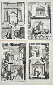
Jan Goeree (1670-1731) - Set av 4 Architecture Engravings - A Reconstruction of the Arch of DomitianProverde Auctions4.3(3)See Sold PriceFeb 28, 2024