ATLAS of ANTIENT GEOGRAPHY by SAMUEL BUTLER 1843John McInnis Auctioneers,LLC4.6(502)See Sold PriceFeb 24, 2024
18TH C. ANTIQUE MAP: FRENCH & INDIAN WAR, FRAMEDThomaston Place Auction Galleries4.4(386)See Sold PriceFeb 24, 2024
Rand McNally Railroad Map Cabinet w/ 21 Railroad MapsRail & Road Auctions4.6(165)See Sold PriceMar 08, 2024
Keith Haring - Ink on New York Map, Best Buddies, Inscribed, Signed, and DatedSapphire Auction Gallery4(67)See Sold PriceMar 02, 2024
LATE 17TH C. FRENCH MAP OF THE NEW WORLD BY ALEXIS-HUBERT JAILLOT (1632-1712)Thomaston Place Auction Galleries4.4(386)See Sold PriceFeb 24, 2024
Central Railroad of New Jersey Map of Sandy Hook Route-ca. 1903JM Hobby Supply and Railroad Artifact Auctions4.4(126)See Sold PriceFeb 24, 2024
Lot of Six Mixed Atlas Box Cars-HO Scale-New in BoxJM Hobby Supply and Railroad Artifact Auctions4.4(126)See Sold PriceFeb 25, 2024
Rand McNally/Santa Fe Railroad Map of Iowa-1912JM Hobby Supply and Railroad Artifact Auctions4.4(126)See Sold PriceFeb 24, 2024
NICOLAES VISSCHER (NETHERLANDS, 1618-1709) MAP OF THE NEW WORLDThomaston Place Auction Galleries4.4(386)See Sold PriceFeb 24, 2024
17TH C. WORLD MAP BY NICOLAES VISSCHER (NETHERLANDS, 1618-1709)Thomaston Place Auction Galleries4.4(386)See Sold PriceFeb 24, 2024
Lot of Six Mixed Atlas Cabooses-HO Scale-New in BoxJM Hobby Supply and Railroad Artifact Auctions4.4(126)See Sold PriceFeb 25, 2024
1900 Map of IndianaAuthor: Matthews Title: 1900 Map of Indiana Medium: Ink on Paper Dimensions: 13.5"X22" Map of Indiana dated 1900. Published by Matthews-Northrup Co. in Buffalo, NY. Double folio map. Key upper right.See Sold Price
SoldCivil War Book Indiana At Chickamauga 1863 w/ MapIndiana At Chickamauga 1863/1900 Report of Indiana Commissioner Chickamauga National Military Park Indianapolis 1901 with several illustrations and map housed in sleeve.See Sold Price
Sold1900 Map of MontanaAuthor: Mast Title: 1900 Map of Montana Medium: Ink on Paper Dimensions: 13.5"X11" Map of Montana dated 1900. Published by Mast, Crowell and Kirkpatrick. Dated. Key lower left. Color coded for territoSee Sold Price
SoldMAP - Indiana. MendenhallIndiana. Edward Mendenhall, A New Map of Indiana Exhibiting the Counties, Townships, Cities, Villages, and Post Offices. Rail Roads, Canals, and Common Roads, 1869 (dated). Hand Color. An attractive,See Sold Price
Sold1900 Map of CharlestonAuthor: Watson Title: 1900 Map of Charleston Medium: Ink on Paper Dimensions: 11.5"X14.5" Map of the city of Charleston dated 1900. Printed and published by Watson in Chicago. Part of his World Atlas.See Sold Price
Sold1900 Map of the PhilippinesAuthor: Crowell Title: 1900 Map of the Philippines Medium: Ink on Paper Dimensions: 13.5"X22" Map of the Philippines dated 1900. Published by Crowell and Kirkpatrick in New York. Map is dated. DoubleSee Sold Price
1900 Map of DenverAuthor: Cram Title: 1900 Map of Denver Medium: Ink on Paper Dimensions: 14.5"X11.5" Map of the city of Denver dated 1900. Printed and published by George Cram in Chicago. Part of his World Atlas. ColoSee Sold Price
Sold1900 Map of MontanaAuthor: Mast Title: 1900 Map of Montana Medium: Ink on Paper Dimensions: 13.5"X11" Description: Map of Montana dated 1900. Published by Mast, Crowell and Kirkpatrick. Dated. Key lower left. Color codeSee Sold Price
Sold1900 Map of LouisvilleAuthor: Cram Title: 1900 Map of Louisville Medium: Ink on Paper Dimensions: 14.5"X11.5" Map of the city of Louisville dated 1900. Printed and published by George Cram in Chicago. Part of his World AtlSee Sold Price
Sold1900 Map of WisconsinTitle: 1900 Map of Wisconsin Author: Matthews Medium: Ink on Paper Dimensions: 13.5"X21.5" Description: Map of Wisconsin dated 1900. Published by the Matthews-Northrup Co. in Buffalo, New York. DoubleSee Sold Price
Sold1900 Map of ColoradoAuthor: Watson Title: 1900 Map of Colorado Medium: Ink on PaperDimensions: 13.5"X11" Map of Colorado dated 1900. Published by Watson in Chicago. Dated explanation on population, land and water surfaceSee Sold Price
1900 Map of MontanaAuthor: Cram Title: 1900 Map of Montana Medium: Ink on Paper Dimensions: 22"X15" Map of Montana dated 1900. Printed and published by George Cram in Chicago. Part of his Family Atlas. Double folio map.See Sold Price
1900 Map of New JerseyTitle: 1900 Map of New Jersey Author: Matthews Materials: Ink on Paper Dimensions: 10.5"X13.5" Description: Map of New Jersey dated 1900. Printed and published by Matthews and Northrup co. in Buffalo,See Sold Price
Sold1900 Map of AlaskaAuthor: Mast Title: 1900 Map of Alaska Medium: Ink on Paper Dimensions: 21.5"X13.5" Description: Map of Alaska and some parts of British America(present day Canada) dated 1900. Published by Mast, CrowSee Sold Price
INDOCHINA.Siam with British & French spheres. Burma Cambodia Anam 1900 mapTITLE/CONTENT OF MAP: 'Siam, Anam, Cambodia, Cochin China, Tong King' DATE PRINTED: 1900 IMAGE SIZE: Approx 28.5 x 21.0cm, 11 x 8.25 inches (Medium) TYPE: Antique colour map CONDITION: Good; suitableSee Sold Price
1900 Map of AlaskaTitle: 1900 Map of Alaska Author: Mast Medium: Ink on Paper Dimensions: 21.5"X13.5" Double folio map of Alaska and portion of Canada dated 1900. Published by Mast, Crower&Kirkpatrick. This double foliSee Sold Price
Sold19th C Cram RR & Township Map IndianaIndexed Railroad and Township Map of Indiana. Brown cloth cover with gilt. 6" x 3-3/4". Published by Geo. F. Cram Chicago. Interior with Index on rose paper. Map 24" x 17". Fine condition.See Sold Price
Sold1900 Map of ClevelandAuthor: Cram Title: 1900 Map of Cleveland Medium: Ink on paper Dimensions: 14.5"X11.5" Map of Cleveland dated 1900. Engraved and published by George Cram in Chicago. Part of Cram's Universal Atlas. VeSee Sold Price
SoldPocket Map Indiana 1835MAP - YOUNG, J. H. The Tourist's Pocket Map of the State of Indiana.Philadelphia: S. Augustus Mitchell, 1835. Hand-colored engraved folding pocket map (390x325 mm). Folds into publisher's roSee Sold Price
1900 Map of Porto RicoAuthor: Cram Title: 1900 Map of Porto Rico Medium: Ink on paper Dimensions: 22"X14.5" Map of Porto Rico dated 1900. Engraved and published by George Cram in Chicago. Double folio map with lower rightSee Sold Price
1900 Map of GeorgiaAuthor: Watson Title: 1900 Map of Georgia Medium: Ink on Paper Dimensions: 10"X13.5" Map of Georgia dated 1900. Engraved and published by Watson in Georgia. Key upper right. Dated explanation on populSee Sold Price
1900 Map of Maryland and DelawareAuthor: Watson Title: 1900 Map of Maryland and Delaware Medium: Ink on Paper/Glass/Wood Dimensions: 19.5"X16.5" Framed map of Maryland and Delaware dated 1900. Published by Watson in Chicago. Part ofSee Sold Price
ca. 1900 MAP of COLOGNE GERMANY COLORFUL FOLDINGca. 1900 MAP of COLOGNE GERMANY COLORFUL FOLDING ANTIQUE MAP PRE WW2 WALLED CITY ca. 1900 MAP of COLOGNE GERMANY COLORFUL FOLDING ANTIQUE MAP PRE WW2 WALLED CITY Circa 1900 Antique Map of Cologne, GerSee Sold Price
Crawfordsville and Southwestern RY First Mortgage Bond Prospectus Book-1872JM Hobby Supply and Railroad Artifact Auctions4.4(126)See Sold PriceFeb 24, 2024
Michigan Southern and Northern Indiana RR 14th Annual Report-February 28, 1869JM Hobby Supply and Railroad Artifact Auctions4.4(126)See Sold PriceFeb 24, 2024
Rand McNally Township County and Railroad Map of Indiana-1880JM Hobby Supply and Railroad Artifact Auctions4.4(126)See Sold PriceFeb 24, 2024
Early 1900's Railway Service Map, Illinois, Ohio, Indiana, Kentucky, TennesseeConnoisseur Auctions4(333)See Sold PriceFeb 24, 2024
Thirty Pieces of Lackawanna Railroad Ephemera - Chief Engineer Timebook, Map, Public Timetables,Rail & Road Auctions4.6(165)See Sold PriceMar 07, 2024
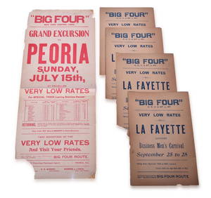
Five Big Four Railroad Broadsheets - Lafayette, Indiana and Peoria, IllinoisRail & Road Auctions4.6(165)See Sold PriceMar 07, 2024
8 Stereoscope Cards - Ships: Columbus Flag Ship, Battleship Indiana 1887-early 1900'sNorth American Artifact Auctions4.6(182)See Sold PriceApr 20, 2024
An Indiana Jones Adventure Opening Year Field Map.Van Eaton Galleries4.6(99)See Sold PriceMar 02, 2024
ANDREW RAYMOND JANSON OIL ON BOARD ADIRONDACKSCharleston Estate Services Ltd.4.5(58)See Sold PriceMar 03, 2024
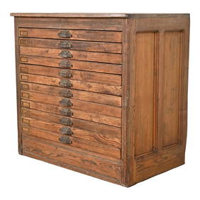
Antique Arts & Crafts Ebonized Oak Architect's Blueprint Flat File Cabinet, Circa 1900Liberty & 33rd Furniture Co.4.4(11)See Sold PriceFeb 27, 2024
Antique Pine 12-Drawer Blueprint Flat File Cabinet by Hamilton, Circa 1900Liberty & 33rd Furniture Co.4.4(11)See Sold PriceFeb 27, 2024
Antique Arts & Crafts Oak Architect's Blueprint Flat File Cabinet, Circa 1900Liberty & 33rd Furniture Co.4.4(11)See Sold PriceFeb 27, 2024
Colonial Africa. British German French Spanish Portuguese Italian TIMES 1900 mapJasper524.5(9.8k)See Sold PriceFeb 28, 2024
Colonial West Africa. Nigeria Cameroon Congo. British German. TIMES 1900 mapJasper524.5(9.8k)See Sold PriceFeb 28, 2024
Colonial Africa North-East. Hejaz Kenya Abyssinia Colonial. THE TIMES 1900 mapJasper524.5(9.8k)See Sold PriceFeb 28, 2024
COLONIAL AFRICA. British East/Central/South Africa. Bechuanaland 1900 old mapJasper524.5(9.8k)See Sold PriceFeb 28, 2024
Colonial Southern Africa. British Portuguese German. Madagascar. TIMES 1900 mapJasper524.5(9.8k)See Sold PriceFeb 28, 2024
Colonial Africa North-West. British French. Nigeria Sahara. THE TIMES 1900 mapJasper524.5(9.8k)See Sold PriceFeb 28, 2024
Francis McNally - Antique Map of Ohio, Indiana & KentuckyProverde Auctions4.3(3)See Sold PriceFeb 28, 2024
Antique EAPG Indiana Glass Bismarc Star or Togo Water GobletsJasper524.5(9.8k)See Sold PriceMar 07, 2024