ATLAS of ANTIENT GEOGRAPHY by SAMUEL BUTLER 1843John McInnis Auctioneers,LLC4.6(502)See Sold PriceFeb 24, 2024
18TH C. ANTIQUE MAP: FRENCH & INDIAN WAR, FRAMEDThomaston Place Auction Galleries4.4(386)See Sold PriceFeb 24, 2024
Rand McNally Railroad Map Cabinet w/ 21 Railroad MapsRail & Road Auctions4.6(165)See Sold PriceMar 08, 2024
Keith Haring - Ink on New York Map, Best Buddies, Inscribed, Signed, and DatedSapphire Auction Gallery4(67)See Sold PriceMar 02, 2024
LATE 17TH C. FRENCH MAP OF THE NEW WORLD BY ALEXIS-HUBERT JAILLOT (1632-1712)Thomaston Place Auction Galleries4.4(386)See Sold PriceFeb 24, 2024
Central Railroad of New Jersey Map of Sandy Hook Route-ca. 1903JM Hobby Supply and Railroad Artifact Auctions4.4(126)See Sold PriceFeb 24, 2024
Lot of Six Mixed Atlas Box Cars-HO Scale-New in BoxJM Hobby Supply and Railroad Artifact Auctions4.4(126)See Sold PriceFeb 25, 2024
Rand McNally/Santa Fe Railroad Map of Iowa-1912JM Hobby Supply and Railroad Artifact Auctions4.4(126)See Sold PriceFeb 24, 2024
NICOLAES VISSCHER (NETHERLANDS, 1618-1709) MAP OF THE NEW WORLDThomaston Place Auction Galleries4.4(386)See Sold PriceFeb 24, 2024
17TH C. WORLD MAP BY NICOLAES VISSCHER (NETHERLANDS, 1618-1709)Thomaston Place Auction Galleries4.4(386)See Sold PriceFeb 24, 2024
Lot of Six Mixed Atlas Cabooses-HO Scale-New in BoxJM Hobby Supply and Railroad Artifact Auctions4.4(126)See Sold PriceFeb 25, 2024
SoldMAP - Indiana. MendenhallIndiana. Edward Mendenhall, A New Map of Indiana Exhibiting the Counties, Townships, Cities, Villages, and Post Offices. Rail Roads, Canals, and Common Roads, 1869 (dated). Hand Color. An attractive,See Sold Price
Sold19th C Cram RR & Township Map IndianaIndexed Railroad and Township Map of Indiana. Brown cloth cover with gilt. 6" x 3-3/4". Published by Geo. F. Cram Chicago. Interior with Index on rose paper. Map 24" x 17". Fine condition.See Sold Price
SoldPocket Map Indiana 1835MAP - YOUNG, J. H. The Tourist's Pocket Map of the State of Indiana.Philadelphia: S. Augustus Mitchell, 1835. Hand-colored engraved folding pocket map (390x325 mm). Folds into publisher's roSee Sold Price
SoldTanner: Antique Map of Indiana, 1843Title/Content of Map: Indiana by Tanner Date Printed: 1843 Cartographer: based on the work of H.C. Tanner Material/Medium: Paper Size: 17" x 14" Hand colored engraved Map. From the first edition publiSee Sold Price
SoldIndiana by ColtonTitle/Content of Map: Indiana by Colton Date Printed: 1859 Cartographer: J.H. Colton Material/Medium: Paper Size: 15" x 17" Provenance: New York From Colton's 'General Atlas.' Published in New York. HSee Sold Price
SoldAntique Map of Indiana by Colton, 1859Title/Content of Map: Indiana by Colton Date Printed: 1859 Cartographer: Material/Medium: Paper Size: 14 x 17" Provenance: New York Please note that this lot has a confidential reserve. When you leaveSee Sold Price
SoldIndiana & OhioTitle/Content of Map: Indiana & Ohio Cartographer: Bradford, Thomas Gamaliel Date: 1835 Publisher: William D. Ticknor / Wiley & Long Size: 17.8Height - 10.1Width Regional map from T.G. Bradford's "A CSee Sold Price
SoldIndiana, Kentucky & Tennessee by H.S. TannerHeading: Author: Tanner, H[enry] S[chenk] Title: Three maps, Indiana, Kentucky and Tennessee Place Published: Philadelphia Publisher:1839-1841 Date Published: Description:See Sold Price
Indiana & OhioTitle/Content of Map: Indiana & Ohio Date: 1861 Cartographer: Johnson Material/Medium: steel engraved Size: 28x18” Provenance: New York Additional Info: Hand colored Reserve: $35.00 Shipping: DomesSee Sold Price
SoldMitchell: Antique Map of Indiana & Ohio, 1869Title/Content of Map: Indiana & Ohio by Mitchell Date Printed: 1869 Cartographer: Augustus S. Mitchell Material/Medium: Paper Size: 15" x 12" Hand colored steel engraved Map. Published in PhiladelphiaSee Sold Price
Colton: Antique Map of Indiana, 1861Title/Content of Map: Indiana by Colton Date Printed: 1861 Cartographer: J.H. Colton Material/Medium: Paper Size: 17 1/2" x 13" Hand colored steel engraved Map from 'Colton's General Atlas'. PublishedSee Sold Price
SoldBradford: Antique Map of Indiana, 1838Title/Content of Map: Indiana by Bradford Date Printed: 1838/1841 Cartographer: Thomas G. Bradford Material/Medium: Paper Size: 13" x 16 1/2" Hand colored. A General Atlas of the World with a SeparateSee Sold Price
SoldPocket Map of Iowa 1856MAP - MENDENHALL, E. (publisher). Map of Iowa Exhibiting the Townships, Cities, Villages, Post Offices, Railroads, Common Roads. Cincinnati: Menedenhall, 1856. Hand-colored engraved folding pSee Sold Price
SoldA New Map of IndianaHeading: (Map - Indiana) Author: Title: A New Map of Indiana Place Published: Philadelphia Publisher:Thomas Cowperthwait Date Published: 1854 Description:See Sold Price
Colton: Antique Map of Indiana, 1861Title/Content of Map: Indiana by Colton Date Printed: 1861 Cartographer: J.H. Colton Size: 15" x 17" Material/Medium: Paper Provenance: New York From 'Colton's General Atlas'. Hand colored steel engraSee Sold Price
Colton: Antique Map of Indiana, 1859Title/Content of Map: Indiana by Colton Date Printed: 1859 Cartographer: H.J. Colton Material/Medium: Paper Size: 17 1/1" x 15" Hand colored,engraved. Published in New York in 'Colton's General Atlas.See Sold Price
Indiana 1886Title/Content of Map: Indiana 1886 Date Printed: 1886 Material/Medium: Paper Size: approx 10.5x13 inches Additional Info: W.H. Stewart & Co., The People's Family atlas Reserve: $30.00 Shipping: DomestSee Sold Price
Indiana 1886Title/Content of Map: Indiana 1886 Date Printed: 1886 Material/Medium: Paper Size: approx 10.5x13 inches Additional Info: W.H. Stewart & Co., The People's Family atlas Reserve: $30.00 Shipping: DomestSee Sold Price
Indiana, Kentucky & Tennessee by H.S. TannerTitle: Three maps, Indiana, Kentucky and Tennessee Author: Tanner, H[enry] S[chenk] Description: Includes: A New Map of Indiana with its Roads & Distances. 34.5x28 cm. (13¾x11"). (Some marginal stainSee Sold Price
Indiana 1886Title/Content of Map: Indiana 1886 Date Printed: 1886 Material/Medium: Paper Size: approx 10.5x13 inches Additional Info: W.H. Stewart & Co., The People's Family atlas Reserve: $30.00 Shipping: DomestSee Sold Price
Indiana & OhioTitle/Content of Map: Indiana & Ohio Date: 1861 Cartographer: Johnson Material/Medium: steel engraved Size: 28x18”Provenance: New York Hand colored Reserve: $40.00 Shipping: Domestic: Free shiSee Sold Price
Indiana & OhioTitle/Content of Map: Indiana & Ohio Date: 1861 Cartographer: Johnson Material/Medium: steel engraved Size: 28x18” Provenance: New York Additional Info: Hand colored Reserve: $55.00 Shipping: DomesSee Sold Price
Indiana & OhioTitle/Content of Map: Indiana & Ohio Date: 1861 Cartographer: Johnson Material/Medium: steel engraved Size: 28x18” Provenance: New York Additional Info: Hand colored Reserve: $45.00 Shipping: DomesSee Sold Price
Indiana.Title/Content of Map: Indiana. Date: 1866 Cartographer: by Johnson Size: 18x29” Provenance: New York. Note a large tear along the right middle of the map. Does effect the union county area on the eaSee Sold Price
Crawfordsville and Southwestern RY First Mortgage Bond Prospectus Book-1872JM Hobby Supply and Railroad Artifact Auctions4.4(126)See Sold PriceFeb 24, 2024
Michigan Southern and Northern Indiana RR 14th Annual Report-February 28, 1869JM Hobby Supply and Railroad Artifact Auctions4.4(126)See Sold PriceFeb 24, 2024
Central Railroad of New Jersey Map of Sandy Hook Route-ca. 1903JM Hobby Supply and Railroad Artifact Auctions4.4(126)See Sold PriceFeb 24, 2024
Rand McNally Township County and Railroad Map of Indiana-1880JM Hobby Supply and Railroad Artifact Auctions4.4(126)See Sold PriceFeb 24, 2024
Rand McNally/Santa Fe Railroad Map of Iowa-1912JM Hobby Supply and Railroad Artifact Auctions4.4(126)See Sold PriceFeb 24, 2024
LATE 17TH C. FRENCH MAP OF THE NEW WORLD BY ALEXIS-HUBERT JAILLOT (1632-1712)Thomaston Place Auction Galleries4.4(386)See Sold PriceFeb 24, 2024
18TH C. ANTIQUE MAP: FRENCH & INDIAN WAR, FRAMEDThomaston Place Auction Galleries4.4(386)See Sold PriceFeb 24, 2024
NICOLAES VISSCHER (NETHERLANDS, 1618-1709) MAP OF THE NEW WORLDThomaston Place Auction Galleries4.4(386)See Sold PriceFeb 24, 2024
Early 1900's Railway Service Map, Illinois, Ohio, Indiana, Kentucky, TennesseeConnoisseur Auctions4(333)See Sold PriceFeb 24, 2024
Early G Unser Stoneware Crock, Jeffersonville Indiana 14.5"T x 12"DiaSwisher Bros. Auction LLC4.4(241)See Sold PriceFeb 24, 2024
Thirty Pieces of Lackawanna Railroad Ephemera - Chief Engineer Timebook, Map, Public Timetables,Rail & Road Auctions4.6(165)See Sold PriceMar 07, 2024
Keith Haring - Ink on New York Map, Best Buddies, Inscribed, Signed, and DatedSapphire Auction Gallery4(67)See Sold PriceMar 02, 2024
Rand McNally Railroad Map Cabinet w/ 21 Railroad MapsRail & Road Auctions4.6(165)See Sold PriceMar 08, 2024
An Indiana Jones Adventure Opening Year Field Map.Van Eaton Galleries4.6(99)See Sold PriceMar 02, 2024
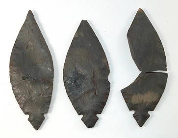
3 Piece Turkey Tail Cache. Found in Jay County, Indiana.Tony Putty Artifacts4.7(404)See Sold PriceMar 09, 2024
Putnam - First Map of the State of Ohio by Rufus PutnamTrillium Antique Prints & Rare Books4.5(30)See Sold PriceFeb 24, 2024
INDIANA JONES AND THE TEMPLE OF DOOM (1984) - Indiana Jones' Screen-Matched Stunt Leather JacketPropstore4.2(6)See Sold PriceMar 12, 2024
Francis McNally - Antique Map of Ohio, Indiana & KentuckyProverde Auctions4.3(3)See Sold PriceFeb 28, 2024