ATLAS of ANTIENT GEOGRAPHY by SAMUEL BUTLER 1843John McInnis Auctioneers,LLC4.6(502)See Sold PriceFeb 24, 2024
18TH C. ANTIQUE MAP: FRENCH & INDIAN WAR, FRAMEDThomaston Place Auction Galleries4.4(386)See Sold PriceFeb 24, 2024
Rand McNally Railroad Map Cabinet w/ 21 Railroad MapsRail & Road Auctions4.6(165)See Sold PriceMar 08, 2024
Keith Haring - Ink on New York Map, Best Buddies, Inscribed, Signed, and DatedSapphire Auction Gallery4(67)See Sold PriceMar 02, 2024
LATE 17TH C. FRENCH MAP OF THE NEW WORLD BY ALEXIS-HUBERT JAILLOT (1632-1712)Thomaston Place Auction Galleries4.4(386)See Sold PriceFeb 24, 2024
Central Railroad of New Jersey Map of Sandy Hook Route-ca. 1903JM Hobby Supply and Railroad Artifact Auctions4.4(126)See Sold PriceFeb 24, 2024
Lot of Six Mixed Atlas Box Cars-HO Scale-New in BoxJM Hobby Supply and Railroad Artifact Auctions4.4(126)See Sold PriceFeb 25, 2024
Rand McNally/Santa Fe Railroad Map of Iowa-1912JM Hobby Supply and Railroad Artifact Auctions4.4(126)See Sold PriceFeb 24, 2024
NICOLAES VISSCHER (NETHERLANDS, 1618-1709) MAP OF THE NEW WORLDThomaston Place Auction Galleries4.4(386)See Sold PriceFeb 24, 2024
17TH C. WORLD MAP BY NICOLAES VISSCHER (NETHERLANDS, 1618-1709)Thomaston Place Auction Galleries4.4(386)See Sold PriceFeb 24, 2024
Lot of Six Mixed Atlas Cabooses-HO Scale-New in BoxJM Hobby Supply and Railroad Artifact Auctions4.4(126)See Sold PriceFeb 25, 2024
1895 Map of IndianapolisAuthor: Cram Title: 1895 Map of Indianapolis Medium: Ink on paper Dimensions: 22"X14.5" Map of Indianapolis dated 1895. Engraved and published by George Cram in Chicago. This double folio map was partSee Sold Price
1895 Map of IndianapolisAuthor: Cram Title: 1895 Map of Indianapolis Medium: Ink on Paper Dimensions: 22"X14.5" Map of Indianapolis dated 1895. Engraved and published by George Cram in Chicago. This double folio map was partSee Sold Price
1895 Map of IndianapolisAuthor: Cram Title: 1895 Map of Indianapolis Medium: Ink on Paper Dimensions: 22"X14.5" Map of Indianapolis dated 1895. Engraved and published by George Cram in Chicago. Double folio map. Part of CramSee Sold Price
1895 Map of IndianapolisAuthor: Cram Title: 1895 Map of Indianapolis Medium: Ink on Paper Dimensions: 22"X14.5" Map of Indianapolis dated 1895. Printed and published by George Cram in Chicago. Part of Cram's Family Atlas. DoSee Sold Price
Sold1895 MAP OF HOUSTON HEIGHTS LITHOGRAPH1895 MAP OF HOUSTON HEIGHTS LITHOGRAPH. FROM THE ESTATE OF BART TRUXILLO. Height: 25 in. by Width: 19 in.See Sold Price
SoldTimes Atlas 1895 Map. North Polar RegionsLithograph Map Published 1895, London for "The Times Atlas" Centre fold as published. Paper Size: 21.5 x 16 inch (54 x 41cm) Good ConditionSee Sold Price
SoldThe Times 1895 Map of Western/Eastern HemisphereLithograph Map Published 1895, London for "The Times Atlas" Paper Size: 21 x 16 inch (53 x 40cm)See Sold Price
Sold1895 Map of AtlantaAuthor: Cram Title: 1895 Map of Atlanta Materials: Ink on Paper/Glass/Wood Dimensions: 16.5"X18.5" Description: Map of the city of Atlanta dated 1895. Published and engraved by George Cram in Chicago.See Sold Price
SoldCIRCA 1895 MAP OF HOUSTON HEIGHTS LITHOGRAPHCIRCA 1895 MAP OF HOUSTON HEIGHTS LITHOGRAPH. PUBLISHER COOLEY. FROM THE ESTATE OF BART TRUXILLO. Height: 25 in. by Width: 19 in.See Sold Price
Sold1895 Map of AfricaAuthor: Cram Title: 1895 Map of Africa Medium: Ink on Paper Dimensions: 14.5"X22.5" Description: Map of Africa dated 1895. Engraved and published by George Cram in Chicago. Double folio map. Key upperSee Sold Price
Sold1895 Map of AtlantaAuthor: Cram Title: 1895 Map of Atlanta Medium: Ink on Paper Dimensions: 11"X14.5" Map of Atlanta dated 1895. Engraved and published by George Cram in Chicago. Very detailed. Colored for geography. HoSee Sold Price
Sold1895 Map of Chicago, Illinois from Atlas of the World1895 Map of Chicago, Illinois from Atlas of the World page 74 Map 11â€Â x 15â€Â H **Age appropriate condition, as seen in photosSee Sold Price
Sold(CIVIL WAR, MAP) The Historical Map. Indianapolis,(CIVIL WAR, MAP) The Historical Map. Indianapolis: Asher, 1862. 12mo, red cloth over printed blue paper boards. 56 pp., with large fold-out color map of the Civil War and four black and white in-textSee Sold Price
Sold1895 Map of Zanzibar Island and adjacent areasTitle/Content of Map: 1895 Map of Zanzibar Island and adjacent areas Date Printed: 1895 Material/Medium: Lithograph Size: 15.5CM*23.5CM Provenance: Leipzig Academy of Literature Reserve: $120.00 ShippSee Sold Price
Sold1895 Map of MinnesotaTitle: 1895 Map of Minnesota Author: Cram Medium: Ink on Paper Dimensions: 14.5"X22" Description: Map of Minnesota dated 1895. Engraved and published by George Cram in Chicago. Part of his World AtlasSee Sold Price
Sold1895 Map of ArizonaTitle: 1895 Map of Arizona Author: Cram Medium: Ink on Paper Dimensions: 14.5"X22" Description: Map of the Arizona territory dated 1895. Engraved and published by George Cram in Chicago. Part of his WSee Sold Price
Sold1895 Map of ChicagoTitle: 1895 Map of Chicago Medium: Ink on Paper Dimensions: 11"X14.5" Description: Map of Chicago dated 1895. Printed and published by George Cram in Chicago. Part of his Family Atlas. Detailed explanSee Sold Price
Sold1895 Map of IowaTitle: 1895 Map of Iowa Author: Cram Medium: Ink on Paper Dimensions: 22"X14.5" Description: Map of Iowa dated 1895. Engraved and published by George Cram in Chicago. Part of his World Atlas. Double fSee Sold Price
Sold1895 Map of Porto RicoAuthor: Cram Title: 1895 Map of Porto Rico Medium: Ink on Paper Dimensions: 22"X14.5" Map of Porto Rico dated 1895. Engraved and published by George Cram in Chicago. Part of his World Atlas. Double foSee Sold Price
ASIA PHYSICAL. Relief Mountain heights Ocean depths Rivers. JOHNSTON 1895 mapTITLE/CONTENT OF MAP: 'The Mountains, Table Lands, Plains & Valleys, of Asia' DATE PRINTED: 1895 IMAGE SIZE: Approx 21.5 x 26.0cm, 8.5 x 10.25 inches (Medium) TYPE: Antique colour map CONDITION: Good;See Sold Price
1895 Map of NevadaAuthor: Cram Title: 1895 Map of Nevada Medium: Ink on Paper Dimensions: 14.5"X22.5" Map of Nevada dated 1895. Engraved and published by George Cram in Chicago. Part of Cram's World Atlas. Double folioSee Sold Price
1895 Map of JapanAuthor: Bartholomew Title: 1895 Map of Japan Materials: Ink on Paper Dimensions: 18"X23" Description: Map of Japan engraved for John Bartholomew and company. Part of the Times Atlas published by the ESee Sold Price
SoldCIVIL WAR 1895 MAP CHICKAMAUGA & DALE GALLON PRINTOriginal 1895 print - Map of the Chickamauga Battlefield sketched by J.C. McElroy , a Captain in the 18th Ohio Infantry. Map measures 30" x 20". Also included is a Dale gallon Signed and numbered 379/See Sold Price
Santa Fe RR Summer in Southern California Book-1895JM Hobby Supply and Railroad Artifact Auctions4.4(126)See Sold PriceFeb 24, 2024
Chicago and Northwestern RY March 17, 1895 Public TimetableJM Hobby Supply and Railroad Artifact Auctions4.4(126)See Sold PriceFeb 24, 2024
JOHN FULTON Coke Coal Mining Rare c1895 1st Edition TreatiseLuis Porretta Fine Arts4.3(10)See Sold PriceMar 02, 2024
Group of Ten Railroad Photographs, Maps, and Prints - New Jersey, Long Island, and New YorkRail & Road Auctions4.6(165)See Sold PriceMar 07, 2024
Eight Louisville, New Albany & Chicago and Chicago, Indianapolis & Louisville Annual ReportsRail & Road Auctions4.6(165)See Sold PriceMar 08, 2024
Railroad Ephemera Group - Hartford, Providence and Fishkill Railroad, Iron Mountain, SouthernRail & Road Auctions4.6(165)See Sold PriceMar 08, 2024
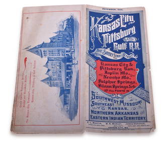
1895 Kansas City, Pittsburg & Gulf Railroad Public TimetableRail & Road Auctions4.6(165)See Sold PriceMar 08, 2024
Jesenske & Mucha's Ballady a Pisne - Ornately Bound Volume with Frontispiece illustrated by MuchaTrillium Antique Prints & Rare Books4.5(30)See Sold PriceFeb 24, 2024
COLONIAL EAST AFRICA. German/British/Portuguese East Africa. Tanzania 1895 mapJasper524.5(9.8k)See Sold PriceFeb 28, 2024
COLONIAL AFRICA. British East/Central/South Africa. Bechuanaland 1895 old mapJasper524.5(9.8k)See Sold PriceFeb 28, 2024
Colonial Southern Africa. British Portuguese German. Madagascar. TIMES 1895 mapJasper524.5(9.8k)See Sold PriceFeb 28, 2024
Colonial Africa North-West. British French. Nigeria Sahara. THE TIMES 1895 mapJasper524.5(9.8k)See Sold PriceFeb 28, 2024
Colonial Africa North-East. Hejaz Kenya Abyssinia Sudan. THE TIMES 1895 mapJasper524.5(9.8k)See Sold PriceFeb 28, 2024
Colonial West Africa. Nigeria Cameroon Congo. British German. TIMES 1895 mapJasper524.5(9.8k)See Sold PriceFeb 28, 2024
Colonial Africa. British German French Spanish Portuguese Italian TIMES 1895 mapJasper524.5(9.8k)See Sold PriceFeb 28, 2024
Henry Seebohm (1832 - 1895) - Set of 2 British Bird Egg Prints - Pink Footed Goose - Brent Goose -Proverde Auctions4.3(3)See Sold PriceFeb 28, 2024
Jules Verne, De La Terre a La Lune, Au Steamer Red MacaronLion and Unicorn4.7(1.8k)See Sold PriceMar 10, 2024
Jules Verne, L'Etoile du Sud, Au Steamer Red MacaronLion and Unicorn4.7(1.8k)See Sold PriceMar 10, 2024