Sold1891 TRAVEL ATLAS OF MASSACHUSETTSGeorge H. Walker & Co., Boston. In leather roll case stamped "Railway Department".See Sold Price
SoldWalker's Map of Nantucket, 1891Walker's Map of Nantucket, 1891, Massachusetts Atlas, Plate No. 10, copyright 1891, 1902, 1904, and 1907, Geo. H. Walker & Co., Boston, in shadow box frame with UF-5 plexiglass , label verso, 20"h x 2See Sold Price
SoldMartha's Vineyard, George H Walker 1891Title: Part of Massachusetts. Atlas Plate No. 11 Subject: Martha's Vineyard Maker: George H. Walker Date: 1891 Materials: Hand colored copperplate engraving Size: 27.5 x 19 inches Identifies the six pSee Sold Price
SoldNantucket, George H Walker 1891Title: Part of Massachusetts. Atlas Plate No. 10 Subject: Nantucket Maker: George H. Walker Date: 1891 Materials: Hand colored copperplate engraving Size: 27.5 x 19 inches Identifies the six principleSee Sold Price
Sold1891 George Walker Massachusetts Atlas Plate No. 10 Map of Nantucket1891 George Walker Massachusetts Atlas Plate No. 10 Map of Nantucket, copyright 1891 G.H. Walker & Co. Boston, Mass, showing Nantucket, Nantucket Sound, Tuckernuck and Muskeget Islands. Sight 19 iSee Sold Price
City of Gloucester.Title/Content of Map: City of Gloucester. Date: 1906 ca. Cartographer: WEBBER, WINSLOW L. Size: 26.75X17.25 "Part of Massachusetts Atlas Copyright 1891, 1900 & 1904. Copyright 1900, 1904 & 1906..." DeSee Sold Price
SoldORIGINAL MAP OF MASSACHUSETTS COAST 18911891 map of the Massachusetts towns of Plymouth, Kingston, Duxbury, Plympton,Bourne etc.. Displaying roads railroad, bodies of water, etc..See Sold Price
Cape Cod Map of BarnstableLater copy of an 1891 Walker’s map of Barnstable Massachusetts with Falmouth, Mashpee, Sandwich, Bourne, Barnstable, etc.. Also showing Buzzard’s Bay and Wareham. Nicely framed. 32â€See Sold Price
SoldCape Cod Map of BarnstableLater copy of an 1891 Walker’s map of Barnstable Massachusetts with Falmouth, Mashpee, Sandwich, Bourne, Barnstable, etc.. Also showing Buzzard’s Bay and Wareham. Nicely framed. 32” x 23 1/2”See Sold Price
SoldBOUND 1891 ATLAS OF MASSACHUSETTS BY GEORGEWALKER & CO., BOSTON, MA; 20" X 15"; 5 FRONT PAGES HAVE MINOR TEARS AND CREASES; FRONT AND REAR BOARDS SHOW WEAR AND SPINE HAS BEEN TAPED; A NUMBER OF PAGES HAVE PENCIL REMARKS IN MARGIN; PP 30 AND 31See Sold Price
SoldMASSACHUSETTS ATLASES 1879 & 1891Two New England atlases, one atlas of Massachusetts 1891, one atlas of Plymouth County 1879, two journals of Stanley Alger, who worked for the government during World War II, photo of family homesteadSee Sold Price
SoldATLAS PLATE OF THE LOWER CAPE Plate No. 9 from theATLAS PLATE OF THE LOWER CAPE Circa 1904 Plate No. 9 from the "Massachusetts Atlas", copyright 1891 and 1904 by Geo. H. Walker, Boston. Depicts Yarmouth, Brewster, Harwich, Chatham and Orleans. 19.75"See Sold Price
SoldWalker Atlas of Massachusetts. Boston 1891O.W. Walker. Atlas of Massachusetts. Boston: 1891. Large folio. Double-page maps. (Repairs.) Modern cloth. (1) (RIJO-A109)(AL) Property From the Estate of Richard I Johnson (1925-2020), Chestnut Hill,See Sold Price
SoldAtlas Of Massachusetts. [Bos: Walker & Co., 1891].[United States/Massachusetts]. [Atlas Of Massachusetts]. [Bos: Walker & Co., 1891]. Prtd color. Oblong folio.See Sold Price
Sold1878 HUGE MAP of Massachusetts & Boston Harbor Rand McNally Plymouth1878 HUGE MAP of Massachusetts & Boston Harbor Rand McNally Plymouth Rand McNally was a notable 19th and early 20th-century American publishing company known for their maps and travel atlases. This enSee Sold Price
SoldComplete Road Atlas42. Complete Road Atlas.Massachusetts and Rhode Island. Index Sheet, Five 28x 30-1/2 inch folding map sheets. Square 4to publisher's cloth portfolio, loose as issued; a few tears at folds, generally cSee Sold Price
SoldMassachusetts. Walker, O.W. Atlas of MassachusettMassachusetts. Walker, O.W. Atlas of Massachusetts. Boston: George Walker, 1891. Folio format imprint; title page, index, and approximately fifty-four large color-printed maps of Massachusetts, rolledSee Sold Price
SoldMASSACHUSETTS ATLASMASSACHUSETTS ATLAS, "Atlas of Massachusetts. / Compiled under the direction of / O. W. Walker, C. E." and "Published by Geo. H. Walker & Co., 160 Tremont St. / Boston, Mass. / Copyright 1891 by Geo.See Sold Price
SoldBOUND ATLAS OF MASSACHUSETTS PUBLISHED BYGEORGE H. WALKER, BOSTON, 1891; 231 PAGES; 20" X 15 1/2"; CLOTH BOUND; SPINE IS SPLIT AND BADLY DETERIORATED; THE BOARDS HAVE BEEN RE-TAPED AND ARE SCUFFED THROUGHOUT; LIGHT FOXING; SOME OF THE PAGESSee Sold Price
SoldAtlas of MassachusettsAtlas of Massachusetts by George H. Walker & Co., 1904 edition, 20" x 15".See Sold Price
Sold1871 Topographical Atlas of Massachusetts, Walling1871 Atlas of Massachusetts complete with twenty-six hand colored printed maps of individual counties and cities with New England and U.S. Map included. Atlas titled, "OFFICIAL TOPOGRAPHICAL ATLAS OFSee Sold Price
Massachusetts. Atlas Plate No.7 [Plymouth]Title: Massachusetts. Atlas Plate No.7 [Plymouth] Publication Date: c1891 Cartographer: ANONYMOUS Publisher: GEO. H. WALKER & CO. Size: 17.5Height - 26Width Road and railroad map showing proposed lineSee Sold Price
SoldTOPOGRAPHICAL ATLAS OF MASSACHUSETTES, 1871"Official Topographical Atlas of Massachusetts, from Astronomical, Trigonometrical and Various Local Surveys; Compiled and Corrected by H. F. Walling & O. W. Gray, 102 Chauncy St. Boston. Published bySee Sold Price
SoldVintage Atlas of the state of MassachusettsThis nice atlas is in good overall condition however the front cover is detached and needs to be reattached. Front page reads Official topographical atlas of Massachusetts from astronomical, trigonomeSee Sold Price
Hermann Dudley Murphy (MA,1867-1945) oil painting antiqueBroward Auction Gallery4.8(277)See Sold PriceMar 31, 2024
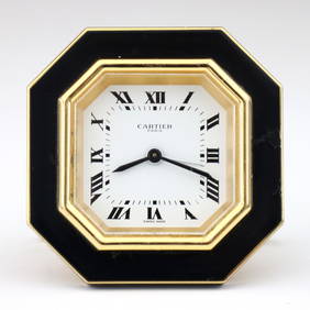
TIFFANY BLUE ENAMEL OCTAGONAL 8 DAY TRAVEL CLOCKThomaston Place Auction Galleries4.4(386)See Sold PriceFeb 25, 2024
CHARLES HENRY GIFFORD (Massachusetts, 1839-1904), Luminist view of three sailboats in a quietEldred's4.7(409)See Sold PriceFeb 28, 2024
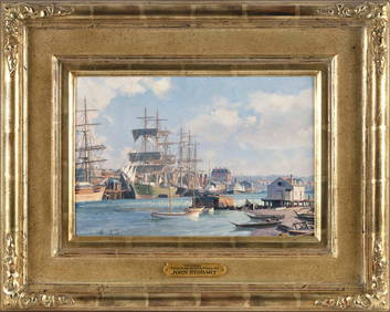
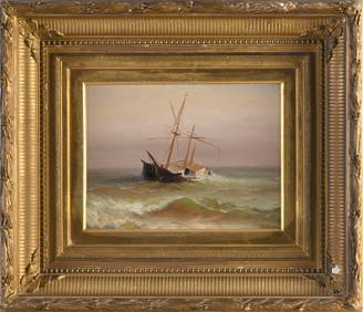
JOHN STOBART (Massachusetts/Florida/England, 1929-2023), "Victoria, View from Songhee Point, 1891".,Eldred's4.7(409)See Sold PriceFeb 27, 2024
CHARLES HENRY GIFFORD (Massachusetts, 1839-1904), Shipwreck., Oil on canvas, 9.5" x 12". Framed 19"Eldred's4.7(409)See Sold PriceFeb 27, 2024
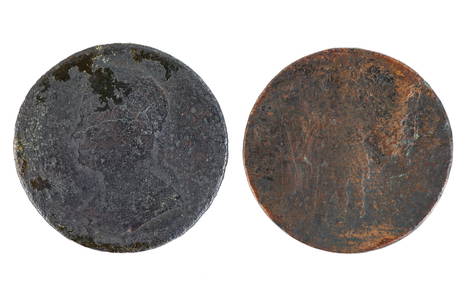
1786 VERMONT PENNY and MASSACHUSETTS COPPER CENTJohn McInnis Auctioneers,LLC4.6(502)See Sold PriceFeb 24, 2024
ATLAS of ANTIENT GEOGRAPHY by SAMUEL BUTLER 1843John McInnis Auctioneers,LLC4.6(502)See Sold PriceFeb 24, 2024
WASHINGTON, JACKSON and other HISTORICAL AMERICANAJohn McInnis Auctioneers,LLC4.6(502)See Sold PriceFeb 24, 2024
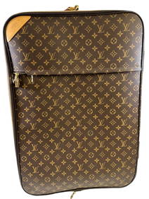
Large Louis Vuitton brown monogram Pegasus 65 roller luggage suitcase weekend travel bag.Neely Auction4.6(224)See Sold PriceFeb 25, 2024
Three Switzerland and Spain Railway Advertising Travel PostersRail & Road Auctions4.6(165)See Sold PriceMar 07, 2024
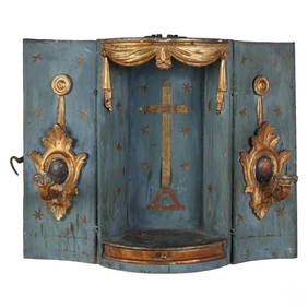
Italian 19C Antique Wood Niche Travel Altar CasketHill Auction Gallery 4.7(1k)See Sold PriceFeb 28, 2024
Model Train Sets in HO Scale, From Athearn, AHM, Atlas, and RoundhouseCain Modern Auctions4.4(44)See Sold PriceFeb 28, 2024
PAULINE LENNARDS PALMER (Illinois/Norway, 1867-1938), Village scene, Provincetown, Massachusetts.,Eldred's4.7(409)See Sold PriceMar 13, 2024
THERESA FERBER BERNSTEIN (New York/Massachusetts, 1891/95-2002), "Streetworkers"., Oil on canvas,Eldred's4.7(409)See Sold PriceMar 13, 2024
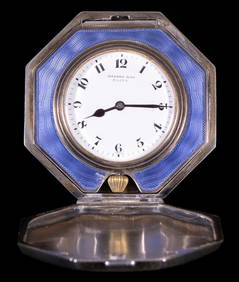
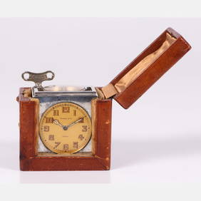
Rare Tiffany & Co. Paris Silver 5 Function Travel Clock in Leather CaseGray's Auctioneers4.5(186)See Sold PriceMar 06, 2024


![Atlas Of Massachusetts. [Bos: Walker & Co., 1891]. (1 of 3)](https://p1.liveauctioneers.com/179/30170/11745934_1_x.jpg?height=282&quality=70&version=1338007155)


![Massachusetts. Atlas Plate No.7 [Plymouth] (1 of 1)](https://p1.liveauctioneers.com/5584/138985/70466031_1_x.jpg?height=282&quality=70&version=1554250661)