ATLAS of ANTIENT GEOGRAPHY by SAMUEL BUTLER 1843John McInnis Auctioneers,LLC4.6(502)See Sold PriceFeb 24, 2024
18TH C. ANTIQUE MAP: FRENCH & INDIAN WAR, FRAMEDThomaston Place Auction Galleries4.4(386)See Sold PriceFeb 24, 2024
Rand McNally Railroad Map Cabinet w/ 21 Railroad MapsRail & Road Auctions4.6(165)See Sold PriceMar 08, 2024
Keith Haring - Ink on New York Map, Best Buddies, Inscribed, Signed, and DatedSapphire Auction Gallery4(67)See Sold PriceMar 02, 2024
LATE 17TH C. FRENCH MAP OF THE NEW WORLD BY ALEXIS-HUBERT JAILLOT (1632-1712)Thomaston Place Auction Galleries4.4(386)See Sold PriceFeb 24, 2024
Central Railroad of New Jersey Map of Sandy Hook Route-ca. 1903JM Hobby Supply and Railroad Artifact Auctions4.4(126)See Sold PriceFeb 24, 2024
Lot of Six Mixed Atlas Box Cars-HO Scale-New in BoxJM Hobby Supply and Railroad Artifact Auctions4.4(126)See Sold PriceFeb 25, 2024
Rand McNally/Santa Fe Railroad Map of Iowa-1912JM Hobby Supply and Railroad Artifact Auctions4.4(126)See Sold PriceFeb 24, 2024
NICOLAES VISSCHER (NETHERLANDS, 1618-1709) MAP OF THE NEW WORLDThomaston Place Auction Galleries4.4(386)See Sold PriceFeb 24, 2024
17TH C. WORLD MAP BY NICOLAES VISSCHER (NETHERLANDS, 1618-1709)Thomaston Place Auction Galleries4.4(386)See Sold PriceFeb 24, 2024
Lot of Six Mixed Atlas Cabooses-HO Scale-New in BoxJM Hobby Supply and Railroad Artifact Auctions4.4(126)See Sold PriceFeb 25, 2024
1890 Map of IdahoAuthor: Mc Nally Title: 1890 Map of Idaho Materials: Ink on Paper Dimensions: 11"X14" Description: Map of Idaho dated 1890. Published by Rand McNally and part of the Atlas of the World. Highly detaileSee Sold Price
Sold1890's Hand Tinted Northwest Territory MapFeatured in this lot we have a hand tinted Northwest US territory maps originating from the 1890's. The map details the Northwest territories including Wyoming, Idaho, and Montana. The map shows mountSee Sold Price
SoldWashington, Oregon, and Idaho USGS Topographic MapsLot of nearly 30 topogaphic maps. 1:125,000 series. c.1890-1910. Includes: 16 Washington, 11 Oregon (incl. Baker) and 2 Idaho (incl. Silver City). Mixed condition with some having rough edges, toning,See Sold Price
Sold1890 Map of HawaiiTitle: 1890 Map of Hawaii Medium: Ink on Paper Dimensions: 14.5"X11" Description: Map of Hawaii dated 1890. Printed and published by Watson in Chicago. Part of his World Atlas. Key upper right. ExplanSee Sold Price
Sold1890 Map of ColoradoAuthor: Watson Title: 1890 Map of Colorado Medium: Ink on Paper Dimensions: 14.5"X11" Map of Colorado dated 1890. Printed and published by Watson in Chicago. Part of his World Atlas. Key lower left. ESee Sold Price
SoldPost Route Map Idaho, Montana & WyomingMarked in ink, Inspector's Office on the label, reading "Post Route Map of the Territory of Idaho, Montana and Wyoming. Linen backed, 19th Century Map of these early territories. 31x42"See Sold Price
Sold1890 Map of TexasAuthor: Gaskell Title: 1890 Map of Texas Medium: Ink on Paper Dimensions: 21.5"X13.5" Map of Texas dated 1890. This double folio map was part of Gaskell's Atlas of the World. Published by John F. WaitSee Sold Price
Sold1890 Map of DenverAuthor: Watson Title: 1890 Map of Denver Medium: Ink on Paper Dimensions: 14.5"X11.5" Map of Denver dated 1890. Engraved and published by Watson in Chicago. Part of his World Atlas. Color coded for geSee Sold Price
Sold1890 Map of ChinaAuthor: Watson Title: 1890 Map of China Medium: Ink on Paper Dimensions: 22.5"X14.5" Map of the Chinese Empire dated 1890. Published by Watson in Chicago. Double folio map. Key lower right. ExplanatioSee Sold Price
SoldLetts & Son 1890 Map of RomePlan of Rome with over a hundred buildings, churches, gardens, arches, ruins, fortifications, plazas, and convents. Conservation framed. MEASUREMENTS: 12" high x 16" wide; overall with frame 19-3/4" hSee Sold Price
Sold1890 Map of OregonAuthor: Watson Title: 1890 Map of Oregon Medium: Ink on Paper Dimensions: 15"X11" Map of Oregon dated 1890. Engraved by Watson. Published by the People's Publishing Co. in Chicago. Key upper middle. CSee Sold Price
Sold75 Helena, Montana 1890 MapsThis lot features 75 Helena Montana maps dated 1890. The maps show the city on this date and was printed in 1890, but these are prints from of the original. The maps measure 11"x17.25" Great map withSee Sold Price
1890 Map of BostonAuthor: Watson Title: 1890 Map of Boston Medium: Ink on Paper Dimensions: 11"X14.5" Map of Boston dated 1890. Printed and engraved by Watson in Chicago. Part of his World Atlas. With steam roads and hSee Sold Price
Sold1890 Map of West TexasTitle: 1890 Map of West Texas Medium: Ink on Paper Dimensions: 14.5"X22.5" Description: Map of West Texas dated 1890. Engraved and published by George Cram in Chicago. Part of his Family Atlas. DoubleSee Sold Price
Sold1890 Map of OmahaAuthor: Cram Title: 1890 Map of Omaha Medium: Ink on Paper Dimensions: 11"X14.5" Map of Omaha dated 1890. Engraved and published by George Cram in Chicago. Very detailed. Color coded for geography. CrSee Sold Price
Sold1890 Map of MontanaAuthor: Watson Title: 1890 Map of Montana Medium: Ink on Paper Dimensions: 22"X14.5" Map of Montana dated 1890. Published by Watson in Chicago. Key lower left. Double folio. Color coded for territoriaSee Sold Price
1890 Map of St. PetersburgAuthor: Cram Title: 1890 Map of St. Petersburg Medium: Ink on Paper Dimensions: 13.5"X11" Map of St. Petersburg dated 189o. Engraved and published by George Cram in Chicago. Part of his World Atlas. VSee Sold Price
1890 Map of St. LouisAuthor: Watson Title: 1890 Map of St. Louis Medium: Ink on Paper Dimensions: 11.5"X14.5" Map of St. Louis dated 1890. Engraved and published by Watson in Chicago. Insets of Carondelet and city center.See Sold Price
Sold1890 Map of ArizonaAuthor: Watson Title: 1890 Map of Arizona Materials: Ink on Paper Dimensions: 11"X14.5" Description: Map of Arizona dated 1890. Printed and published by Watson in Chicago. Part of his Family Atlas. KeSee Sold Price
Sold1890 Map of MadridAuthor: Cram Title: 1890 Map of Madrid Medium: Ink on Paper Dimensions: 14.5"X11.5" Map of Madrid dated 1890. Printed and published by George Cram in Chicago. Part of his Family Atlas. Color coded forSee Sold Price
1890 Map of MontanaAuthor: Cram Title: 1890 Map of Montana Materials: Ink on Paper Size/Dimensions: 22"X14.5" Description: Map of Montana dated 1890. Printed and published by George Cram in Chicago. Part of his Family ASee Sold Price
Sold1890 Map of MexicoAuthor: Cram Title: 1890 Map of Mexico Medium: Ink on Paper Dimensions: 22"X14.5" Map of Mexico dated 1890. Printed and published by George Cram in Chicago. Double folio map. Inset of Lower CaliforniaSee Sold Price
1890 Map of RomeAuthor: Bulla Title: 1890 Map of Rome Medium: Ink on paper Dimensions: 25"X21" Black and white hand drawn map of Rome dated 1890. Published by the famous Bulla house in Milan. Detailed with monumentsSee Sold Price
1890 Map of Massachussetts/Connecticut/Rhode IslandTitle: 1890 Map of Massachussetts/Connecticut/Rhode Island Author: Watson Medium: Ink on Paper Dimensions: 22"X15" Map of Massachussets, Connecticut and Rhode Island from Watson's Illustrated Atlas ofSee Sold Price
Crams Township and Railroad Map of New York-1890JM Hobby Supply and Railroad Artifact Auctions4.4(126)See Sold PriceFeb 24, 2024
Northern Pacific RR Washington and Northern Idaho Map Folder-1941JM Hobby Supply and Railroad Artifact Auctions4.4(126)See Sold PriceFeb 24, 2024
Eastern RR Summer Book of Tours-1884JM Hobby Supply and Railroad Artifact Auctions4.4(126)See Sold PriceFeb 24, 2024
Southern Pacific RR Book West By South-Half South-1890JM Hobby Supply and Railroad Artifact Auctions4.4(126)See Sold PriceFeb 24, 2024
Chicago Burlington and Quincy RR Spring 1890 Public TimetableJM Hobby Supply and Railroad Artifact Auctions4.4(126)See Sold PriceFeb 24, 2024
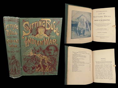
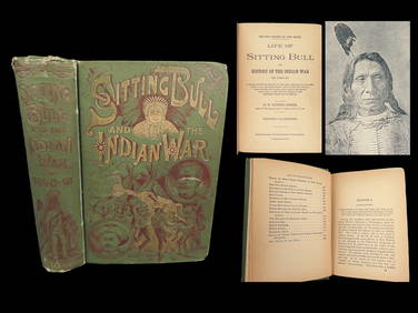
1891 Sitting Bull 1st ed Life Native American Sioux Indians DAKOTA Ghost DanceSchilb Antiquarian Rare Books4.8(421)See Sold PriceMar 10, 2024
18TH C. ANTIQUE MAP: FRENCH & INDIAN WAR, FRAMEDThomaston Place Auction Galleries4.4(386)See Sold PriceFeb 24, 2024
1891 DAKOTA Indians 1st ed Life Sitting Bull Native American Sioux Ghost DanceSchilb Antiquarian Rare Books4.8(421)See Sold PriceMar 31, 2024
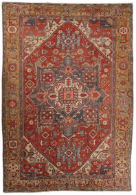
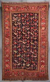
A VERY FINE SOUTHWEST PERSIAN RUG WITH BIRDS CIRCA 1890Soulis Auctions4.8(953)See Sold PriceFeb 24, 2024
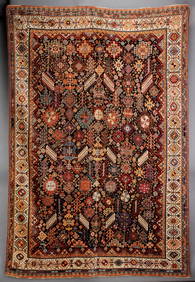
A FINE ANTIQUE SOUTHWEST PERSIAN QASHQUAI RUG C. 1890Soulis Auctions4.8(953)See Sold PriceFeb 24, 2024
AN ANTIQUE MOGHAN CAUCASIAN LONG RUN CARPET CIRCA 1890Soulis Auctions4.8(953)See Sold PriceFeb 24, 2024
NORTH & WEST AFRICA. Gold Coast (Ghana) Slave Coast. Tribal names 1890 mapJasper524.5(9.8k)See Sold PriceFeb 28, 2024
Central Africa. Map showing great forest traversed by Mr Stanley, 1890Jasper524.5(9.8k)See Sold PriceFeb 28, 2024
Francis McNally - Antique Map of Washington, Oregon, Idaho, Nevada, Utah & ArizonaProverde Auctions4.3(3)See Sold PriceFeb 28, 2024