ATLAS of ANTIENT GEOGRAPHY by SAMUEL BUTLER 1843John McInnis Auctioneers,LLC4.6(502)See Sold PriceFeb 24, 2024
18TH C. ANTIQUE MAP: FRENCH & INDIAN WAR, FRAMEDThomaston Place Auction Galleries4.4(386)See Sold PriceFeb 24, 2024
Rand McNally Railroad Map Cabinet w/ 21 Railroad MapsRail & Road Auctions4.6(165)See Sold PriceMar 08, 2024
Keith Haring - Ink on New York Map, Best Buddies, Inscribed, Signed, and DatedSapphire Auction Gallery4(67)See Sold PriceMar 02, 2024
LATE 17TH C. FRENCH MAP OF THE NEW WORLD BY ALEXIS-HUBERT JAILLOT (1632-1712)Thomaston Place Auction Galleries4.4(386)See Sold PriceFeb 24, 2024
Central Railroad of New Jersey Map of Sandy Hook Route-ca. 1903JM Hobby Supply and Railroad Artifact Auctions4.4(126)See Sold PriceFeb 24, 2024
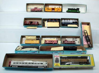
Lot of Six Mixed Atlas Box Cars-HO Scale-New in BoxJM Hobby Supply and Railroad Artifact Auctions4.4(126)See Sold PriceFeb 25, 2024
Rand McNally/Santa Fe Railroad Map of Iowa-1912JM Hobby Supply and Railroad Artifact Auctions4.4(126)See Sold PriceFeb 24, 2024
NICOLAES VISSCHER (NETHERLANDS, 1618-1709) MAP OF THE NEW WORLDThomaston Place Auction Galleries4.4(386)See Sold PriceFeb 24, 2024
17TH C. WORLD MAP BY NICOLAES VISSCHER (NETHERLANDS, 1618-1709)Thomaston Place Auction Galleries4.4(386)See Sold PriceFeb 24, 2024
Lot of Six Mixed Atlas Cabooses-HO Scale-New in BoxJM Hobby Supply and Railroad Artifact Auctions4.4(126)See Sold PriceFeb 25, 2024
Sold1872 Warner Beers Map of Southern US -- Map of theReserve Reduced! Title/Content of Map: 1872 Warner Beers Map of Southern US -- Map of the Southern States Date: 1872, Chicago Cartographer: Warner Beers Size: 16.7 x 27.3 in. This is a nice large doubSee Sold Price
1872 Warner Beers Map of Southern US -- Map of theTitle/Content of Map: 1872 Warner Beers Map of Southern US -- Map of the Southern States Date: 1872, Chicago Cartographer: Warner Beers Size: 16.7 x 27.3 in. This is a nice large double page map of moSee Sold Price
1872 Warner Beers Map of Southern US -- Map of theTitle/Content of Map: 1872 Warner Beers Map of Southern US -- Map of the Southern States Date: 1872, Chicago Cartographer: Warner Beers Size: 16.7 x 27.3 in. This is a nice large double page map of moSee Sold Price
1872 Warner Beers Map of Southern US -- Map of theTitle/Content of Map: 1872 Warner Beers Map of Southern US -- Map of the Southern States Date Printed: 1872, Chicago Cartographer: Warner Beers Size: 16.7 x 27.3 in. This is a nice large double page mSee Sold Price
Sold1862, 1872 Maps - VA, Southern States1862 Johnson map of Richmond, VA (18 x 27"). 1872 Warner & Beers map of Southern States (29 x 18).See Sold Price
1872 Warner Beers Map Western Portion of SouthernTitle/Content of Map: 1872 Warner Beers Map Western Portion of Southern States -- County Map of Tennessee, Kentucky, Alabama. Mississippi, Arkansas and Louisiana Date: 1872, Chicago Cartographer: WarnSee Sold Price
Sold1872 Warner Beers Map Western Portion of SouthernReserve Reduced! Title/Content of Map: 1872 Warner Beers Map Western Portion of Southern States -- County Map of Tennessee, Kentucky, Alabama. Mississippi, Arkansas and Louisiana Date: 1872, Chicago CSee Sold Price
1872 Warner Beers Map Western Portion of SouthernTitle/Content of Map: 1872 Warner Beers Map Western Portion of Southern States -- County Map of Tennessee, Kentucky, Alabama. Mississippi, Arkansas and Louisiana Date: 1872, Chicago Cartographer: WarnSee Sold Price
1872 Warner Beers Map Western Portion of SouthernTitle/Content of Map: 1872 Warner Beers Map Western Portion of Southern States -- County Map of Tennessee, Kentucky, Alabama. Mississippi, Arkansas and Louisiana Date Printed: 1872, Chicago CartographSee Sold Price
1872 Map of The Central StatesThis colorful map of the central states of the U.S. was published by Warner & Beers for a larger atlas of the entire country by H. H. Lloyd in 1872. It shows the counties of 9 states from coastal DelaSee Sold Price
SoldTWO MAPS OF MONTANA AND REGION, 1872 AND 1917Includes a 'County Map of Idaho, Montana and Wyoming,' by Warner and Beers, with many US Army forts shown. Professionally matted, 13.75 x 16 inch sight size. Also a 1917 'Pocket Map of Montana,' by ThSee Sold Price
1872 Warner & Beers Map of the Caribbean -- Map of theTitle: 1872 Warner & Beers Map of the Caribbean -- Map of the West Indies Date: 1872, Chicago Cartographer: Warner & Beers Size: 15.7 x 13.8 in. Additional Information: A highly detailed map of the CaSee Sold Price
1872 Warner & Beers Map of the Caribbean -- Map of theTitle/Content of Map: 1872 Warner & Beers Map of the Caribbean -- Map of the West Indies Date: 1872, Chicago Cartographer: Warner & Beers Size: 15.7 x 13.8 in. A highly detailed map of the Caribbean,See Sold Price
Sold1872 Warner & Beers Map of the Caribbean -- Map of theTitle/Content of Map: 1872 Warner & Beers Map of the Caribbean -- Map of the West Indies Date: 1872, Chicago Cartographer: Warner & Beers Size: 15.7 x 13.8 in. A highly detailed map of the Caribbean,See Sold Price
1872 Warner & Beers Map of the Caribbean -- Map of theTitle/Content of Map: 1872 Warner & Beers Map of the Caribbean -- Map of the West Indies Date: 1872, Chicago Cartographer: Warner & Beers Size: 15.7 x 13.8 in. A highly detailed map of the Caribbean,See Sold Price
1872 Warner & Beers Map of the Caribbean -- Map of theTitle/Content of Map: 1872 Warner & Beers Map of the Caribbean -- Map of the West Indies Date Printed: 1872, Chicago Cartographer: Warner & Beers Size: 15.7 x 13.8 in. A highly detailed map of the CarSee Sold Price
1872 Warner & Beers Map of the Caribbean -- Map of theTitle/Content of Map: 1872 Warner & Beers Map of the Caribbean -- Map of the West Indies Date: 1872, Chicago Cartographer: Warner & Beers Size: 15.7 x 13.8 in. A highly detailed map of the Caribbean,See Sold Price
1872 Warner & Beers Map of the Caribbean -- Map of theTitle/Content of Map: 1872 Warner & Beers Map of the Caribbean -- Map of the West Indies Date: 1872, Chicago Cartographer: Warner & Beers Size: 15.7 x 13.8 in. A highly detailed map of the Caribbean,See Sold Price
1872 Warner & Beers Map of the Caribbean -- Map of theTitle: 1872 Warner & Beers Map of the Caribbean -- Map of the West Indies Date: 1872, Chicago Cartographer: Warner & Beers Size: 15.7 x 13.8 in. Additional Information: A highly detailed map of the CaSee Sold Price
1872 Warner & Beers Map of the Caribbean -- Map of theTitle/Content of Map: 1872 Warner & Beers Map of the Caribbean -- Map of the West Indies Date: 1872, Chicago Cartographer: Warner & Beers Size: 15.7 x 13.8 in. A highly detailed map of the Caribbean,See Sold Price
1872 Warner & Beers Map of the Caribbean -- Map of theTitle/Content of Map: 1872 Warner & Beers Map of the Caribbean -- Map of the West Indies Date: 1872, Chicago Cartographer: Warner & Beers Size: 15.7 x 13.8 in. A highly detailed map of the Caribbean,See Sold Price
Warner & Beers: Antique Map of the Caribbean, 1872Title/Content of Map: 1872 Warner & Beers Map of the Caribbean -- Map of the West Indies Date Printed: 1872, Chicago Cartographer: Warner & Beers Size: 15.7 x 13.8 in. A highly detailed map of the CarSee Sold Price
Warner & Beers: Antique Map of the Caribbean, 1872Title/Content of Map: 1872 Warner & Beers Map of the Caribbean -- Map of the West Indies Date Printed: 1872, Chicago Cartographer: Warner & Beers Size: 15.7 x 13.8 in. A highly detailed map of the CarSee Sold Price
Warner & Beers: Antique Map of the Caribbean, 1872Title/Content of Map: 1872 Warner & Beers Map of the Caribbean -- Map of the West Indies Date Printed: 1872, Chicago Cartographer: Warner & Beers Size: 15.7 x 13.8 in. A highly detailed map of the CarSee Sold Price
Michigan Southern and Northern Indiana RR 14th Annual Report-February 28, 1869JM Hobby Supply and Railroad Artifact Auctions4.4(126)See Sold PriceFeb 24, 2024
Central Railroad of New Jersey Map of Sandy Hook Route-ca. 1903JM Hobby Supply and Railroad Artifact Auctions4.4(126)See Sold PriceFeb 24, 2024
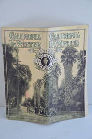
Los Angeles and Salt Lake RR California in Winter Brochure-October 1912JM Hobby Supply and Railroad Artifact Auctions4.4(126)See Sold PriceFeb 24, 2024
Santa Fe RR Summer in Southern California Book-1895JM Hobby Supply and Railroad Artifact Auctions4.4(126)See Sold PriceFeb 24, 2024
Southern Pacific RR Four Gateways to the Pacific Coast Brochure-1917JM Hobby Supply and Railroad Artifact Auctions4.4(126)See Sold PriceFeb 24, 2024
Southern Pacific RR Oregon Outdoors Brochure-May 1916JM Hobby Supply and Railroad Artifact Auctions4.4(126)See Sold PriceFeb 24, 2024
FLYING A TOURING SERVICE U.S. ROAD MAPS TIN WALL DISPLAY.Dan Morphy Auctions4.2(1.3k)See Sold PriceFeb 25, 2024
1885 CIVIL WAR 1ed Famous Memoirs US Grant Sheridan Sherman 6v RARE LOT MapsSchilb Antiquarian Rare Books4.8(421)See Sold PriceMar 10, 2024
LATE 16TH C. MAP OF SCOTLAND BY MERCATOR, FRAMEDThomaston Place Auction Galleries4.4(386)See Sold PriceFeb 24, 2024
Rand McNally Railroad Map Cabinet w/ 21 Railroad MapsRail & Road Auctions4.6(165)See Sold PriceMar 08, 2024
[CIVIL WAR]. Archive identified to African American soldier William H. Wade, 20th US Colored Troops,Freeman's | Hindman4.4(1.6k)See Sold PriceFeb 27, 2024
[VIETNAM]. A group of approx. 120 photographs assembled by African American soldier Vernon CliftonFreeman's | Hindman4.4(1.6k)See Sold PriceFeb 27, 2024
1816 MAP SOUTHERN PART OF RUSSIA or MUSCOVY in EUROPE copper engraving ANTIQUEJasper524.5(9.8k)See Sold PriceFeb 27, 2024
GEORGE ANDREW CORLEY (DATES UNKNOWN) U.S. TEAM SKI TRYOUTS / MT. HOOD OREGON. 1939.Swann Auction Galleries4.4(65)See Sold PriceFeb 29, 2024
RARE ANTIQUE GERMAN METTLACH STONEWARE BEER STEINAntique Arena Inc.4.5(852)See Sold PriceMar 02, 2024
1683 Sanson Map of the Caribbean -- Les Isles Antilles, &c Entre Lesquelles sont les Lucayes, et lesJasper524.5(9.8k)See Sold PriceFeb 27, 2024
Athern HO Gauge incomplete Diesel/GP 38 Spokane Portland and Seattle Diesel/Burlington Northern CowHarris Toy and Train Auctions4.5(122)See Sold PriceMar 01, 2024
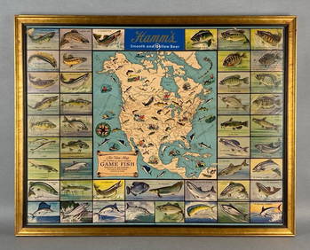
Hamms Air-View Map of Game Fish Advertising Beer PosterMatthew Bullock Auctioneers4.7(1.8k)See Sold PriceMar 02, 2024


![[CIVIL WAR]. Archive identified to African American soldier William H. Wade, 20th US Colored Troops, (1 of 3)](https://p1.liveauctioneers.com/197/319238/171468121_1_x.jpg?height=282&quality=70&version=1707520367)
![[VIETNAM]. A group of approx. 120 photographs assembled by African American soldier Vernon Clifton (1 of 6)](https://p1.liveauctioneers.com/197/319238/171468143_1_x.jpg?height=282&quality=70&version=1707520367)