ATLAS of ANTIENT GEOGRAPHY by SAMUEL BUTLER 1843John McInnis Auctioneers,LLC4.5(505)See Sold PriceFeb 24, 2024
18TH C. ANTIQUE MAP: FRENCH & INDIAN WAR, FRAMEDThomaston Place Auction Galleries4.4(393)See Sold PriceFeb 24, 2024
Rand McNally Railroad Map Cabinet w/ 21 Railroad MapsRail & Road Auctions4.6(165)See Sold PriceMar 08, 2024
Keith Haring - Ink on New York Map, Best Buddies, Inscribed, Signed, and DatedSapphire Auction Gallery4(67)See Sold PriceMar 02, 2024
LATE 17TH C. FRENCH MAP OF THE NEW WORLD BY ALEXIS-HUBERT JAILLOT (1632-1712)Thomaston Place Auction Galleries4.4(393)See Sold PriceFeb 24, 2024
Central Railroad of New Jersey Map of Sandy Hook Route-ca. 1903JM Hobby Supply and Railroad Artifact Auctions4.4(127)See Sold PriceFeb 24, 2024
Lot of Six Mixed Atlas Box Cars-HO Scale-New in BoxJM Hobby Supply and Railroad Artifact Auctions4.4(127)See Sold PriceFeb 25, 2024
Rand McNally/Santa Fe Railroad Map of Iowa-1912JM Hobby Supply and Railroad Artifact Auctions4.4(127)See Sold PriceFeb 24, 2024
NICOLAES VISSCHER (NETHERLANDS, 1618-1709) MAP OF THE NEW WORLDThomaston Place Auction Galleries4.4(393)See Sold PriceFeb 24, 2024
17TH C. WORLD MAP BY NICOLAES VISSCHER (NETHERLANDS, 1618-1709)Thomaston Place Auction Galleries4.4(393)See Sold PriceFeb 24, 2024
Lot of Six Mixed Atlas Cabooses-HO Scale-New in BoxJM Hobby Supply and Railroad Artifact Auctions4.4(127)See Sold PriceFeb 25, 2024
Sold1860 Walling Map of Vermont w/ 1859 Hagar1860 Walling Map of Vermont, with inset 1859 Albert Hager Geological Map of Vermont, 5' 4" x 5' 3"chips, lossesSee Sold Price
Sold1857/ 1860 Walling “Map of the State of Vermont” w1857/ 1860 Walling “Map of the State of Vermont” w Albert Hager inset Geological map, town maps & vignettes, includes 1860 census numbers, but lacks the date 1860 in Walling's legend, 64” x 62��See Sold Price
SoldNEW ENGLAND FRAMED MAP-1860, COUNTY MAP OF THE STATESNEW ENGLAND FRAMED MAP-1860, COUNTY MAP OF THE STATES OF NEW YORK, NEW HAMPSHIRE, VERMONT, MASSACHUSETTS, RHODE ID. AND CONNECTICUT, CONSTRUCTED & ENGRAVED BY W.WILLIAMS PHILADELPHIA, MAP MEASURES 13See Sold Price
Sold1860 WALL MAP OF NYC NEW YORKMap of New York and its Environs. H.F. Walling, published by S.D. Tilden 1860. Dimensions: (Open) H 64" x W 64" Condition: Separated from wooden rolled. Signs of age including losses, crazing, bendingSee Sold Price
Samuel Augustus Mitchell (1790-1868), "County Map ofSamuel Augustus Mitchell (1790-1868), "County Map of New York, New Hampshire, Vermont, Massachusettes, Rhode Island and Connecticut," 1860, H. - 15 1/4 in., W. - 22 1/2 in.See Sold Price
SoldCivil War Era Map of the United StatesMap of the United States and Territories. Henry F. Walling (1825 - 1889) & Ormando W. Gray (fl. 1860 – 1880). Lithographed Map. Boston, 1871. 17 x 25 1/2 inches sheetSee Sold Price
SoldTwo Maps by Johnson & Browning, "Austria, Turkey,Two Maps by Johnson & Browning, "Austria, Turkey, Greece," 1859; together with "Northern and Southern Italy," 1860-1863, hand colored, Italy- H.- 26 1/2 in., W.- 36 in., Austria- H.- 18 in., W.- 26 1/See Sold Price
SoldColton: Antique Map of Vermont, 1859Title/Content of Map: Vermont by Colton Date Printed: 1859 Cartographer: H.J. Colton Material/Medium: Paper Size: 17 1/2" x 15" Hand colored,engraved. Published in New York in 'Colton's General Atlas.See Sold Price
1822 F Lucas Geographical, Statistical, & Historical1822 F Lucas Geographical, Statistical, & Historical Map of Vermont w/ letterpress text printed on the map, image 16.5” x 20.5”See Sold Price
Sold1860 Dutton / Walling Case Map of Boston -- Map ofReserve Reduced! Title/Content of Map: 1860 Dutton / Walling Case Map of Boston -- Map of Boston and the County Adjacent Date: 1860 New York / Boston Cartographer: E Dutton / H Walling Size: 41.3 x 30See Sold Price
1860 Dutton / Walling Case Map of Boston -- Map ofTitle/Content of Map: 1860 Dutton / Walling Case Map of Boston -- Map of Boston and the County Adjacent Date: 1860 New York / Boston Cartographer: E Dutton / H Walling Size: 41.3 x 30.7 in. unfolded,See Sold Price
1860 Dutton / Walling Case Map of Boston -- Map ofTitle/Content of Map: 1860 Dutton / Walling Case Map of Boston -- Map of Boston and the County Adjacent Date: 1860 New York / Boston Cartographer: E Dutton / H Walling Size: 41.3 x 30.7 in. unfolded,See Sold Price
1860 Dutton / Walling Case Map of Boston -- Map ofTitle/Content of Map: 1860 Dutton / Walling Case Map of Boston -- Map of Boston and the County Adjacent Date: 1860 New York / Boston Cartographer: E Dutton / H Walling Size: 41.3 x 30.7 in. unfolded,See Sold Price
Sold3 New Mexico Maps, 1859, 1860, 18631) Sketch of Public Surveys in New Mexico to accompany the annual survey general for 1863. 20x20â€. John A. Clark. Aging along folds. 2) Sketch of Public Surveys in New Mexico to accompany the annuSee Sold Price
Sold(2) GEOGRAPHY/ATLAS INC. WARNER'S 1859LOT (2) GEOGRAPHY/ATLAS INC. GUYOTS 1875; WARNER'S 1859 W/MAPSSee Sold Price
SoldGrouping of 18 -19th century pamphlets, most of VerGrouping of 18 -19th century pamphlets, most of Vermont, including Geographical and Historical Poem of Vermont 1852 w/foldout Vermont map, Leavitt's Song Book - Green Mountain Minstrels - Vermont 1868See Sold Price
SoldAFRICAN EXPLORATION VOLUMES, LOT OF SIXAFRICAN EXPLORATION VOLUMES, LOT OF SIX, comprising Richard F. Burton (1821-1890), "The Lake Regions of Central Africa", 1860, with fold-out map; W. Winwood Reade (1838-1875), "Savage Africa", 1864, wSee Sold Price
Sold1860 California Map by S.A. Mitchell w/ Salt Lake &Beautiful 1860 County Map of California, with inset of Salt Lake Country, Utah, and inset of San Francisco Bay and Vicinity, by S.A. Mitchell. Frame-able condition. Nice color and great detail. "EnterSee Sold Price
H. F. WALLING - MAP OF BOSTON, 1860H. F. Walling - Map Of Boston, 1860 - 23 X 30 In. - This Giclée Print Is Gallery Stretched And Ready To Hang Or Lean Against A Wall, Or Display On An Easel. - A Giclée Print Is The Highest Quality PSee Sold Price
H. F. WALLING - MAP OF BOSTON, 1860H. F. Walling - Map Of Boston, 1860 - 33 3/4 X 44 In. This is a Giclée on Canvas. Very Large Piece!See Sold Price
H. F. Walling - Map Of Boston, 1860H. F. Walling - Map Of Boston, 1860 Size: 33 3/4 X 44 In. - This Is A Gallery Stretched Giclee Print On Canvas. The Piece Was Printed On High Quality Artist Grade 350 Gsm, Acid-free, Archival Canvas ASee Sold Price
1860 Map of New Hampshire and VermontAuthor: Johnson Title: 1860 Map of New Hampshire and Vermont Medium: Ink on Paper Dimensions: 18"X26.5" Map of New Hampshire and Vermont dated 1860. Printed by A.J.Johnson. Published by Johnson and WaSee Sold Price
H. F. Walling - Map Of Boston, 1860H. F. Walling - Map Of Boston, 1860 Size: 27 5/8 X 36 In. - This Is A Gallery Stretched Giclee Print On Canvas. The Piece Was Printed On High Quality Artist Grade 350 Gsm, Acid-free, Archival Canvas ASee Sold Price
H. F. Walling - Map Of Boston, 1860H. F. Walling - Map Of Boston, 1860 - 30 5/8 X 40 In. - Giclée On Canvas - Museum Wrapped - Large Piece Of Art - This Piece Is Ready To Hang On Your WallSee Sold Price
Golden Plover Pair by Joseph W. Lincoln (1859-1938)Copley Fine Art Auctions4.5(40)See Sold PriceFeb 24, 2024
Early Pennsylvania Railroad Literature - 1881 New York and Chicago Limited Timetable Brochure andRail & Road Auctions4.6(165)See Sold PriceMar 07, 2024
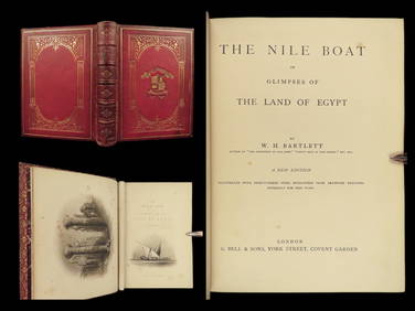
1880 Niles Boat Egypt Voyages Sphinx Pyramids Valley of Kings Illustrated MAPSSchilb Antiquarian Rare Books4.8(428)See Sold PriceMar 31, 2024
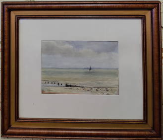
Philip Wilson Steer W/C of an English Seascape w/ SailboatHeritage Gallery Auctions4.4(60)See Sold PriceMar 10, 2024
Vintage Vanguard Studio wall map, dated 1968South Jersey Auction by Babington Auction Inc4.6(124)See Sold PriceFeb 25, 2024
Rand McNally Railroad Map Cabinet w/ 21 Railroad MapsRail & Road Auctions4.6(165)See Sold PriceMar 08, 2024
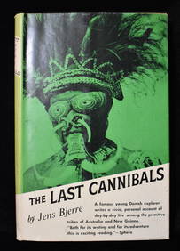
THE LAST CANNIBALS by JENS BJERRE 1957 Fine or Near FineNorth American Artifact Auctions4.7(198)See Sold PriceApr 20, 2024
Willem Blaeu, Etc. 17th C. Antiquarian Maps, 2Auctions at Showplace4.6(740)See Sold PriceMar 17, 2024
Spectacular orientalist battle representing the Battle of Tetouan with Catalan infantry troopsTemplum Fine Art Auctions4.3(8)See Sold PriceFeb 28, 2024
1738 BIBLE in DUTCH ILLUSTRATED w/ MAPS MASSIVE FOLIO in DUTCH antique BIBLIAJasper524.5(9.9k)See Sold PriceFeb 27, 2024
C. 1820 VERMONT SIDEBOARD , CHERRY W/ MAPLE BURL VENEERS (46" X 40" X 181/2")Carlsen Gallery, Inc.4.6(164)See Sold PriceMar 03, 2024
30 Volumes of Scott’s Waverly NovelsBroken Arch Auction Gallery NCFL#93994.6(300)See Sold PriceMar 04, 2024
Two Hand-Colored 19th Century Maps of New Orleans and Louisiana, Larger- H.- 12 1/2 in., W.- 15 1/2Crescent City Auction Gallery4.3(231)See Sold PriceMar 08, 2024
French Napoleon III Marble Top Parquetry Walnut Commode, c. 1860, H.- 40 1/2 in. W.- 49 in., D.- 20Crescent City Auction Gallery4.3(231)See Sold PriceMar 09, 2024