ATLAS of ANTIENT GEOGRAPHY by SAMUEL BUTLER 1843John McInnis Auctioneers,LLC4.5(494)See Sold PriceFeb 24, 2024
18TH C. ANTIQUE MAP: FRENCH & INDIAN WAR, FRAMEDThomaston Place Auction Galleries4.4(386)See Sold PriceFeb 24, 2024
Rand McNally Railroad Map Cabinet w/ 21 Railroad MapsRail & Road Auctions4.6(165)See Sold PriceMar 08, 2024
Keith Haring - Ink on New York Map, Best Buddies, Inscribed, Signed, and DatedSapphire Auction Gallery3.9(67)See Sold PriceMar 02, 2024
LATE 17TH C. FRENCH MAP OF THE NEW WORLD BY ALEXIS-HUBERT JAILLOT (1632-1712)Thomaston Place Auction Galleries4.4(386)See Sold PriceFeb 24, 2024
Central Railroad of New Jersey Map of Sandy Hook Route-ca. 1903JM Hobby Supply and Railroad Artifact Auctions4.4(126)See Sold PriceFeb 24, 2024
Lot of Six Mixed Atlas Box Cars-HO Scale-New in BoxJM Hobby Supply and Railroad Artifact Auctions4.4(126)See Sold PriceFeb 25, 2024
Rand McNally/Santa Fe Railroad Map of Iowa-1912JM Hobby Supply and Railroad Artifact Auctions4.4(126)See Sold PriceFeb 24, 2024
NICOLAES VISSCHER (NETHERLANDS, 1618-1709) MAP OF THE NEW WORLDThomaston Place Auction Galleries4.4(386)See Sold PriceFeb 24, 2024
17TH C. WORLD MAP BY NICOLAES VISSCHER (NETHERLANDS, 1618-1709)Thomaston Place Auction Galleries4.4(386)See Sold PriceFeb 24, 2024
Lot of Six Mixed Atlas Cabooses-HO Scale-New in BoxJM Hobby Supply and Railroad Artifact Auctions4.4(126)See Sold PriceFeb 25, 2024
Sold1860 Dutton / Walling Case Map of Boston -- Map ofReserve Reduced! Title/Content of Map: 1860 Dutton / Walling Case Map of Boston -- Map of Boston and the County Adjacent Date: 1860 New York / Boston Cartographer: E Dutton / H Walling Size: 41.3 x 30See Sold Price
1860 Dutton / Walling Case Map of Boston -- Map ofTitle/Content of Map: 1860 Dutton / Walling Case Map of Boston -- Map of Boston and the County Adjacent Date: 1860 New York / Boston Cartographer: E Dutton / H Walling Size: 41.3 x 30.7 in. unfolded,See Sold Price
1860 Dutton / Walling Case Map of Boston -- Map ofTitle/Content of Map: 1860 Dutton / Walling Case Map of Boston -- Map of Boston and the County Adjacent Date: 1860 New York / Boston Cartographer: E Dutton / H Walling Size: 41.3 x 30.7 in. unfolded,See Sold Price
1860 Dutton / Walling Case Map of Boston -- Map ofTitle/Content of Map: 1860 Dutton / Walling Case Map of Boston -- Map of Boston and the County Adjacent Date: 1860 New York / Boston Cartographer: E Dutton / H Walling Size: 41.3 x 30.7 in. unfolded,See Sold Price
H. F. WALLING - MAP OF BOSTON, 1860H. F. Walling - Map Of Boston, 1860 - 23 X 30 In. - This Giclée Print Is Gallery Stretched And Ready To Hang Or Lean Against A Wall, Or Display On An Easel. - A Giclée Print Is The Highest Quality PSee Sold Price
H. F. WALLING - MAP OF BOSTON, 1860H. F. Walling - Map Of Boston, 1860 - 33 3/4 X 44 In. This is a Giclée on Canvas. Very Large Piece!See Sold Price
H. F. Walling - Map Of Boston, 1860H. F. Walling - Map Of Boston, 1860 Size: 33 3/4 X 44 In. - This Is A Gallery Stretched Giclee Print On Canvas. The Piece Was Printed On High Quality Artist Grade 350 Gsm, Acid-free, Archival Canvas ASee Sold Price
H. F. Walling - Map Of Boston, 1860H. F. Walling - Map Of Boston, 1860 Size: 27 5/8 X 36 In. - This Is A Gallery Stretched Giclee Print On Canvas. The Piece Was Printed On High Quality Artist Grade 350 Gsm, Acid-free, Archival Canvas ASee Sold Price
H. F. Walling - Map Of Boston, 1860H. F. Walling - Map Of Boston, 1860 - 30 5/8 X 40 In. - Giclée On Canvas - Museum Wrapped - Large Piece Of Art - This Piece Is Ready To Hang On Your WallSee Sold Price
H. F. WALLING - MAP OF BOSTON, 1860H. F. Walling - Map Of Boston, 1860 - 27 5/8 X 36 In. - This Giclée Print Is Gallery Stretched And Ready To Hang Or Lean Against A Wall, Or Display On An Easel. - A Giclée Print Is The Highest QualiSee Sold Price
H. F. WALLING - MAP OF BOSTON, 1860H. F. Walling - Map Of Boston, 1860 - 33 3/4 X 44 In. - This Giclée Print Is Gallery Stretched And Ready To Hang Or Lean Against A Wall, Or Display On An Easel. - A Giclée Print Is The Highest QualiSee Sold Price
H. F. Walling - Map Of Boston, 1860H. F. Walling - Map Of Boston, 1860 Size: 33 3/4 X 44 In. - This Is A Gallery Stretched Giclee Print On Canvas. The Piece Was Printed On High Quality Artist Grade 350 Gsm, Acid-free, Archival Canvas ASee Sold Price
H. F. WALLING - MAP OF BOSTON, 1860H. F. Walling - Map Of Boston, 1860 - 30 5/8 X 40 In. - Giclée On Canvas - Museum Wrapped - Large Piece Of Art - This Piece Is Ready To Hang On Your WallSee Sold Price
H. F. WALLING - MAP OF BOSTON, 1860H. F. Walling - Map Of Boston, 1860 - 27 5/8 X 36 In. - This Giclée Print Is Gallery Stretched And Ready To Hang Or Lean Against A Wall, Or Display On An Easel. - A Giclée Print Is The Highest QualiSee Sold Price
H. F. WALLING - MAP OF BOSTON, 1860H. F. Walling - Map Of Boston, 1860 - 30 5/8 X 40 In. - This Giclée Print Is Gallery Stretched And Ready To Hang Or Lean Against A Wall, Or Display On An Easel. - A Giclée Print Is The Highest QualiSee Sold Price
H. F. WALLING -MAP OF BOSTON, 1860 - GICLÉE ON CANVASH. F. Walling -map Of Boston, 1860 - Giclée On Canvas -33 3/4 X 44 In. - A Giclée Print Is The Highest Quality Print Available Today. Because There Is No Visible Dot Screen Pattern, The Resulting ImSee Sold Price
H. F. WALLING - MAP OF BOSTON, 1860H. F. WALLING - MAP OF BOSTON, 1860 - Giclée on Canvas - Size-33 3/4 x 44 in.See Sold Price
H. F. WALLING - MAP OF BOSTON, 1860H. F. Walling - Map Of Boston, 1860 - 33 3/4 X 44 In. - This Giclée Print Is Gallery Stretched And Ready To Hang Or Lean Against A Wall, Or Display On An Easel. - A Giclée Print Is The Highest QualiSee Sold Price
H. F. WALLING - MAP OF BOSTON, 1860H. F. Walling - Map Of Boston, 1860 - 33 3/4 X 44 In. - Gallery Stretched The Piece Of Art Is Ready To Hang Or Lean Against A Wall, Or Display On An Easel. - A Giclée Print Is The Highest Quality PriSee Sold Price
H. F. WALLING -MAP OF BOSTON, 1860 - GICLÉE ON CANVASH. F. Walling -map Of Boston, 1860 - Giclée On Canvas -30 5/8 X 40 In. - A Giclée Print Is The Highest Quality Print Available Today. Because There Is No Visible Dot Screen Pattern, The Resulting ImSee Sold Price
SoldCivil War Era Map of the United StatesMap of the United States and Territories. Henry F. Walling (1825 - 1889) & Ormando W. Gray (fl. 1860 – 1880). Lithographed Map. Boston, 1871. 17 x 25 1/2 inches sheetSee Sold Price
SoldWALLING, H. F. Map of Addison County Vermont.WALLING, H. F. Map of Addison County Vermont. Hand-colored lithographed case map in 24 sections, 1440x1430 mm overall; linen-backed; with a case. Boston, 1857 A beautiful county map typical of the perSee Sold Price
Sold1857/ 1860 Walling “Map of the State of Vermont” w1857/ 1860 Walling “Map of the State of Vermont” w Albert Hager inset Geological map, town maps & vignettes, includes 1860 census numbers, but lacks the date 1860 in Walling's legend, 64” x 62��See Sold Price
Sold1860 Walling Map of Vermont w/ 1859 Hagar1860 Walling Map of Vermont, with inset 1859 Albert Hager Geological Map of Vermont, 5' 4" x 5' 3"chips, lossesSee Sold Price
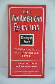
Chicago Burlington and Quincy RR Pan-American Exposition Flyer-1901JM Hobby Supply and Railroad Artifact Auctions4.4(126)See Sold PriceFeb 24, 2024
Eastern RR Summer Book of Tours-1884JM Hobby Supply and Railroad Artifact Auctions4.4(126)See Sold PriceFeb 24, 2024
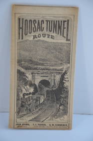
Fitchburg Railroad 1880 Hoosac Tunnel Route Public TimetableJM Hobby Supply and Railroad Artifact Auctions4.4(126)See Sold PriceFeb 24, 2024
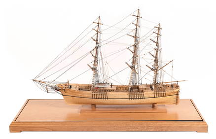
OUTSTANDING CASED MODEL OF THE CLIPPER SHIP "FLYING CLOUD" 20th Century Case height 28.75". LengthEldred's4.7(403)See Sold PriceFeb 28, 2024
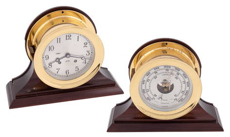
CHELSEA SHIP'S BELL CLOCK AND BAROMETER SET Boston, Massachusetts, 20th Century Bezel diametersEldred's4.7(403)See Sold PriceFeb 28, 2024
CHELSEA SHIP'S BELL CLOCK RETAILED BY RIGGS & BRO., PHILADELPHIA Boston, Circa 1901 Bezel diameterEldred's4.7(403)See Sold PriceFeb 27, 2024
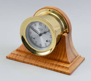
CHELSEA SHIPSTRIKE MANTEL CLOCK Boston, 20th Century Height on base 7.5". Width 10".Eldred's4.7(403)See Sold PriceFeb 27, 2024
CHELSEA SHIP'S BELL BAROMETER Boston, Late 20th Century Diameter 7.5". Depth 3.5".Eldred's4.7(403)See Sold PriceFeb 27, 2024
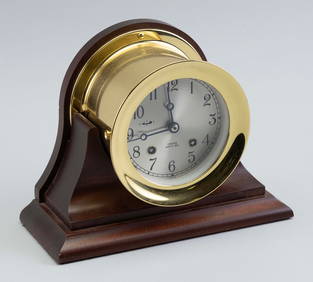
CHELSEA SHIP'S BELL MANTEL CLOCK Boston, Contemporary Clock diameter 5.5". Height on stand 7.5".Eldred's4.7(403)See Sold PriceFeb 27, 2024
Vintage Full Color World Map LithographThe Benefit Shop Foundation Inc.4.3(2.9k)See Sold PriceFeb 28, 2024
Nova Totius Full Color Geographical World MapThe Benefit Shop Foundation Inc.4.3(2.9k)See Sold PriceFeb 28, 2024
Vintage 1955 German Leather Map CaseThe Benefit Shop Foundation Inc.4.3(2.9k)See Sold PriceFeb 28, 2024
Large lot of assorted prints. 18th-20th century. To include: North American and other maps, CivilTremont Auctions4.6(292)See Sold PriceFeb 25, 2024
1818 RARE Geography Made Easy MAPS Jedidiah Morse Boston Indians Atlas AsiaSchilb Antiquarian Rare Books4.8(415)See Sold PriceMar 31, 2024
Rand McNally Railroad Map Cabinet w/ 21 Railroad MapsRail & Road Auctions4.6(165)See Sold PriceMar 08, 2024
Arrowsmith & Lewis - Map of North AmericaTrillium Antique Prints & Rare Books4.5(28)See Sold PriceFeb 24, 2024
Arrowsmith & Lewis - Map of the United StatesTrillium Antique Prints & Rare Books4.5(28)See Sold PriceFeb 24, 2024
CHELSEA SHIP'S BELL BAROMETER Boston, Late 20th Century Diameter 5.5". Depth 3.5".Eldred's4.7(403)See Sold PriceMar 07, 2024
Two Hand-Colored 19th Century Maps of New Orleans and Louisiana, Larger- H.- 12 1/2 in., W.- 15 1/2Crescent City Auction Gallery4.3(229)See Sold PriceMar 08, 2024
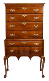
FINE 18TH C. BOSTON CHIPPENDALE MAPLE HIGHBOY.William Smith Auctions4.6(145)See Sold PriceMar 06, 2024
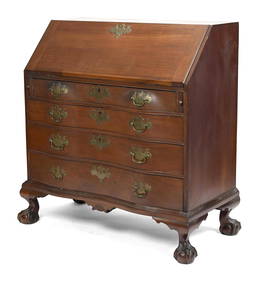
18TH C. BOSTON MA CHIPPENDALE MAHOGANY OXBOW DESK.William Smith Auctions4.6(145)See Sold PriceMar 06, 2024