ATLAS of ANTIENT GEOGRAPHY by SAMUEL BUTLER 1843John McInnis Auctioneers,LLC4.6(502)See Sold PriceFeb 24, 2024
18TH C. ANTIQUE MAP: FRENCH & INDIAN WAR, FRAMEDThomaston Place Auction Galleries4.4(386)See Sold PriceFeb 24, 2024
Rand McNally Railroad Map Cabinet w/ 21 Railroad MapsRail & Road Auctions4.6(165)See Sold PriceMar 08, 2024
Keith Haring - Ink on New York Map, Best Buddies, Inscribed, Signed, and DatedSapphire Auction Gallery4(67)See Sold PriceMar 02, 2024
LATE 17TH C. FRENCH MAP OF THE NEW WORLD BY ALEXIS-HUBERT JAILLOT (1632-1712)Thomaston Place Auction Galleries4.4(386)See Sold PriceFeb 24, 2024
Central Railroad of New Jersey Map of Sandy Hook Route-ca. 1903JM Hobby Supply and Railroad Artifact Auctions4.4(126)See Sold PriceFeb 24, 2024
Lot of Six Mixed Atlas Box Cars-HO Scale-New in BoxJM Hobby Supply and Railroad Artifact Auctions4.4(126)See Sold PriceFeb 25, 2024
Rand McNally/Santa Fe Railroad Map of Iowa-1912JM Hobby Supply and Railroad Artifact Auctions4.4(126)See Sold PriceFeb 24, 2024
NICOLAES VISSCHER (NETHERLANDS, 1618-1709) MAP OF THE NEW WORLDThomaston Place Auction Galleries4.4(386)See Sold PriceFeb 24, 2024
17TH C. WORLD MAP BY NICOLAES VISSCHER (NETHERLANDS, 1618-1709)Thomaston Place Auction Galleries4.4(386)See Sold PriceFeb 24, 2024
Lot of Six Mixed Atlas Cabooses-HO Scale-New in BoxJM Hobby Supply and Railroad Artifact Auctions4.4(126)See Sold PriceFeb 25, 2024
1857 HYDROGRAHIC FRAMED CAPE COD CHARTDated 1857. Preliminary chart No. #4 of the coast of United states. From Plymouth Mass to Sakonnet River RI. Map later framed. 32 inches x 29 inches. Overall 39 inches x 29 inches. Weight 13 pounds. FSee Sold Price
Sold1857 HYDROGRAPHIC FRAMED CAPE COD CHARTDated 1857. Preliminary chart No. #4 of the coast of United states. From Plymouth Mass to Saughkonner River RI. Map later framed. 32 inches x 29 inches. Overall 39 inches x 29 inches. Weight 13 poundsSee Sold Price
SoldChart of Cape Cod 1857Title: Provincetown Harbor, Massachusetts Author: U.S. Coast Survey Description: Lithographed chart, modern hand-coloring. 37x44 cm. (14½x17½").Chart of the tip of Cape Cod. Heading: zzhPlace PublisSee Sold Price
Framed Chart of Cape Cod Bay"Handcolored copy of an early Cape Cod by chart published in 1872. Shows the entire bay and surrounding landscape from Duxbury Bay to Provincetown. Framed in painted gold. 37"" high x 45"" wide."See Sold Price
SoldFramed 1872 Chart of Cape Cod Bay1872 chart showing Cape Cod Bay from Duxbury Beach to Provincetown. Mounted into a black and gold frame. 34 tall x 43 wide. Condition: very goodSee Sold Price
SoldFramed 1872 Chart of Cape Cod Bay1872 chart showing Cape Cod Bay from Duxbury Beach to Provincetown. Mounted into a black and gold frame. 34 tall x 43 wide. Condition: very goodSee Sold Price
SoldMid 19th C. Framed "Coast Chart # 10"Mid 19th Century framed "Coast Chart #10" Cape Cod Bay by the US Coast Survey, 34 1/2 x 43. Fair condition, staining and paper loss.See Sold Price
Eldridge chart of Cape Cod Bay, 19011901 original George W. Eldridge chart of Cape cod Bay. the chart displays the waters in fathoms from Chatham to Gloucester with important cities, towns and harbors noted. Framed. 59” tall x 35” wSee Sold Price
Eldridge chart of Cape Cod Bay, 19011901 original George W. Eldridge chart of Cape cod Bay. the chart displays the waters in fathoms from Chatham to Gloucester with important cities, towns and harbors noted. Framed. 59” tall x 35” wSee Sold Price
Sold18th C. Reprint Chart Showing Cape Cod, Martha's18th Century reprint chart showing Cape Cod, Martha's Vineyard and Nantucket Island as well as a small enlarged area of Plymouth Bay, nicely matted and framed 29 1/2 x 39 1/2.See Sold Price
SoldVineyard Sound chart by EldridgeHand colored copy of a George Eldridge original chart from 1877 showing Martha's Vineyard, Nantucket and part of Cape Cod. Nicely framed with glass 39" high x 57" wideSee Sold Price
SoldChart of Cape CodHand colored copy of a George W. Eldridge chart showing Cotuit and Osterville on Cape Cod. Matted and framed. 34" high x 40" wide.See Sold Price
SoldLate 19th Century Chart of Outer Cape CodLate 19th Century map of outer Cape Cod by Walker Lithograph and Publishing Co. Chart shows the outer Cape from Eastham to Provincetown. Matted and framed. Overall dimensions 27" x 33". On sight 19 1/See Sold Price
SoldBoston Bay and Massachusetts Bay chart19th century coast survey chart showing Boston Bay and approaches and Massachusetts Bay. Includes the coast from Cape Ann down to Cape cod. A used old original chart now framed in burlwood. 44 1/2”See Sold Price
SoldCopy of 19th C. Massachusetts Bay ChartCopy of a 19th Century Massachusetts Bay Chart showing Cape Ann to Cape Cod. Originally published in 1872. Framed with glass. Overall dimensions 32 x41. Condition: very good.See Sold Price
SoldFramed chart of Nantucket SoundCirca 1958, ocean chart showing “Nantucket Sound and Approaches”. Also shows the south coast of Cape Cod from Buzzard’s Bay to Chatham including Monomoy Island. Framed in a painted silver moldinSee Sold Price
Soldlarge framed chart showing Martha's Vineyard, Nantlarge framed chart showing Martha's Vineyard, Nantucket and the coast of Cape Cod from the Elizabeth Islands to Chatham - 32" x 52"See Sold Price
SoldFramed Chart of the Atlantic CoastFramed chart of the Atlantic coast from Cape Sable to Cape Hattaras from 1908 by the US Coastal Survey. Highlights include New Brunswick, Nova Scotia, Cape Cod, Martha's Vineyard, Long Island, NorfolkSee Sold Price
SoldHand colored chart of Massachusetts.Massachusetts Bay chart. Detailed, hand colored chart showing the Mass coast from Chatham around the tip of Cape Cod and up to Gloucester. Recreation of a 1912 Eldridge chart. Framed with glass. 62" hSee Sold Price
SoldChart of Vineyard Sound and Nantucket Shoals.Fine recreation of the 1877 Eldridge chart showing Martha's Vineyard, Nantucket, the Elizabeth Islands and the Cape Cod coast from Falmouth to Chatham. Nicely framed. 38" high x 56" wide.See Sold Price
SoldGEORGE ELDRIDGE CHART OF VINEYARD SOUND AND NANTUCKETGEORGE ELDRIDGE CHART OF VINEYARD SOUND AND NANTUCKET SHOALS Late 19th/Early 20th Century Also depicts parts of Cape Cod. 28.5" x 48.75" sight. Framed 32.5" x 53".See Sold Price
SoldJoseph Milne Impressionist Cow Landscape PaintingJoseph Milne United Kingdom,1857-1911 Impressionist landscape of cows grazing in a pasture. Oil on Board Signed lower right. Board measures 13 1/2" x 19",framed 21 1/4" x 26 1/2" From a Cape Cod, MassSee Sold Price
SoldAntique Framed Cape Cod Hooked RugEarly 20th C. framed hooked rug depicting Cape Cod. Rug decorated with sailboat, seahorse, cottage and rope border, set in period mahogany frame. Measures: 23.75" H x 36" WSee Sold Price
SoldFramed Cape Cod Needlework MapItem/Description: Vintage Cap Codd (Cape Cod) Embroidered Map. 'Cap Codd' as the locals say it, and as is spelled on this 1930s piece of Americana. (Textile Art, Sampler, Cross Stitch, Antique, MassacSee Sold Price
LATE 18TH C. VERY LARGE CHART OF NORTHEAST CANADA BY DES BARRES (1721-1824), 1780, FRAMEDThomaston Place Auction Galleries4.4(386)See Sold PriceFeb 24, 2024
George Adomeit (American 1879-1964) CAPE COD LandscapePremier Auction Galleries4.3(329)See Sold PriceMar 09, 2024
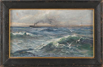
ARTHUR VIDAL DIEHL (Massachusetts/New York/England, 1870-1929), Steamship in open waters., Oil onEldred's4.7(409)See Sold PriceFeb 27, 2024
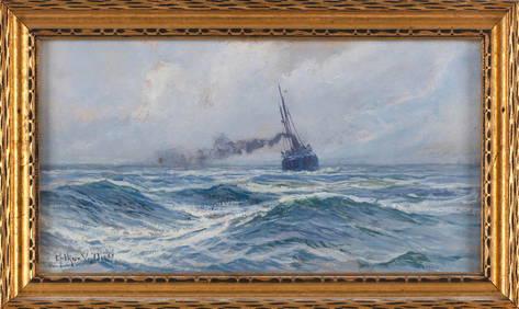
ARTHUR VIDAL DIEHL (Massachusetts/New York/England, 1870-1929), Steamship at sea., Oil on board, 6"Eldred's4.7(409)See Sold PriceFeb 27, 2024
CHRISTOPHER BLOSSOM (Connecticut, 1956-), "The Bark Superior in the Bering Strait"., Oil on canvas,Eldred's4.7(409)See Sold PriceFeb 27, 2024
SMALL CASED MODEL OF THE TWO-MASTED "SUE B." OF CAPE COD 20th Century Case height 9.75". LengthEldred's4.7(409)See Sold PriceFeb 27, 2024
HERMES Cape Cod 23cm Quartz Belt Watch Stainless Steel Leather SilverBidhaus4.3(747)See Sold PriceFeb 26, 2024
GEORGE GUSTAV ADOMEIT (1879-1967) "CAPE COD".Amelia Jeffers, Auctioneers & Appraisers4.6(101)See Sold PriceMar 07, 2024
N. CAMERON WATSON (Massachusetts, 1955-), Portrait of a woman., Mixed media collage, 4.75" x 5"Eldred's4.7(409)See Sold PriceMar 13, 2024
ODIN KAESELAU SMITH (Massachusetts, 1965-), Two Cape Cod viewsEldred's4.7(409)See Sold PriceMar 13, 2024
FOUR CAPE COD WATERCOLORS 20th Century Framed from 9" x 13" to 19" x 23".Eldred's4.7(409)See Sold PriceMar 07, 2024
1988 Cape Cod Prospects A's Ballpark Card #23- Jeff Bagwell- Beckett Graded 93 Kings Auction4.3(194)See Sold PriceFeb 24, 2024
Michael Davidoff (NY,France,b 1944) watercolor paintingBroward Auction Gallery4.8(277)See Sold PriceMay 19, 2024
Vintage Cape Cod Frolic One Gallon CoolerRapid Estate Liquidators and Auction Gallery4.5(1.1k)See Sold PriceFeb 26, 2024
Hermes Cape Cod Double Tour Quartz Watch Stainless Steel and Leather 29Golden Air Auctions4.4(257)See Sold PriceFeb 26, 2024
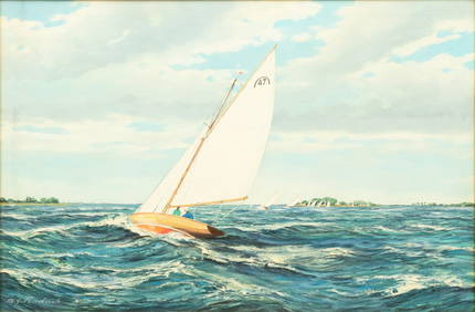
M. G. Friedrich (German/American (20th C.)) Oil on Canvas Ca. 1950, "Sailing Off Cape Cod", H 24" WDuMouchelles4.6(825)See Sold PriceMar 15, 2024