ATLAS of ANTIENT GEOGRAPHY by SAMUEL BUTLER 1843John McInnis Auctioneers,LLC4.6(502)See Sold PriceFeb 24, 2024
18TH C. ANTIQUE MAP: FRENCH & INDIAN WAR, FRAMEDThomaston Place Auction Galleries4.4(386)See Sold PriceFeb 24, 2024
Rand McNally Railroad Map Cabinet w/ 21 Railroad MapsRail & Road Auctions4.6(165)See Sold PriceMar 08, 2024
Keith Haring - Ink on New York Map, Best Buddies, Inscribed, Signed, and DatedSapphire Auction Gallery4(67)See Sold PriceMar 02, 2024
LATE 17TH C. FRENCH MAP OF THE NEW WORLD BY ALEXIS-HUBERT JAILLOT (1632-1712)Thomaston Place Auction Galleries4.4(386)See Sold PriceFeb 24, 2024
Central Railroad of New Jersey Map of Sandy Hook Route-ca. 1903JM Hobby Supply and Railroad Artifact Auctions4.4(126)See Sold PriceFeb 24, 2024
Lot of Six Mixed Atlas Box Cars-HO Scale-New in BoxJM Hobby Supply and Railroad Artifact Auctions4.4(126)See Sold PriceFeb 25, 2024
Rand McNally/Santa Fe Railroad Map of Iowa-1912JM Hobby Supply and Railroad Artifact Auctions4.4(126)See Sold PriceFeb 24, 2024
NICOLAES VISSCHER (NETHERLANDS, 1618-1709) MAP OF THE NEW WORLDThomaston Place Auction Galleries4.4(386)See Sold PriceFeb 24, 2024
17TH C. WORLD MAP BY NICOLAES VISSCHER (NETHERLANDS, 1618-1709)Thomaston Place Auction Galleries4.4(386)See Sold PriceFeb 24, 2024
Lot of Six Mixed Atlas Cabooses-HO Scale-New in BoxJM Hobby Supply and Railroad Artifact Auctions4.4(126)See Sold PriceFeb 25, 2024
1855 Map of the Eastern HemisphereAuthor: Colton Title: 1855 Map of the Eastern Hemisphere Materials: Ink on Paper Dimensions: 14.5"X17.5" Description: Map of the Eastern Hemisphere dated 1855. Engraved and published by J.H. Colton inSee Sold Price
Sold1855 Colton Map of Eastern Hemisphere -- EasternTitle/Content of Map: 1855 Colton Map of Eastern Hemisphere -- Eastern Hemisphere Date: 1855, New York Cartographer: J Colton Size: 14.5 X 13.7 in. This is an excellent hemispherical map. The coastlinSee Sold Price
SoldJohnson, Alvin Jewett & Ward East & West 1855 MapJohnson, Alvin Jewett and Ward Eastern & Western Hemispheres 1855, from Johnson's New Illustrated Family Atlas 1855 . Dimensions: 13" X 13"Inv.27-28See Sold Price
SoldTallis, John (Pub) 1852 Map. Eastern HemisphereSteel Engraved Map with Original Outline Hand Color Published 1852-56 by John Tallis, London for "The Universal Pronouncing Dictionary" by Thomas Wright. Drawn & Engraved by John Rapkin. Centre fold aSee Sold Price
Bonne: Oblique Projection Map Eastern Hemisphere, 1787Title/Content of Map: Eastern Hemisphere - Antique 45 Degree Northern Oblique Projection. "Mappe-Monde sur le plan Horizontal situe a 45 d. de latitude Nord. Hemisphere Oriental." Date Printed: 1787 CSee Sold Price
SoldColored Map Eastern Hemisphere, O. W. Gray, 1873Colored Map Eastern Hemisphere, O. W. Gray, 1873See Sold Price
SoldVintage Framed Map - Eastern HemisphereVintage Framed Map - Eastern Hemisphere. New York and London. Professionally framed. Measures 19 x 25 inches.See Sold Price
SoldMap, Eastern Hemisphere, Thomson [Lon: c1814-1817Eastern Hemisphere. Engraved double page circular hemisphere map, from John Thomson's ''A New General Atlas,'' Lon: c.1814-1817. Original hand-coloring, 19 7/8 in. diameter.See Sold Price
Sold(2) Framed Maps, Eastern Hemisphere British IslesTwo framed maps showing Eastern Hemisphere and British Isles. Circa 1888. Overall dimensions 19" x 16". Condition: good.See Sold Price
SoldTallis/Rapkin: Antique Map of Eastern Hemisphere, 1849TITLE/CONTENT OF MAP: 'Eastern Hemisphere' The steamship mail route from Britain to Asia is indicated in blue DATE PRINTED: 1849 IMAGE SIZE: Approx 26.5 x 34.5cm, 10.5 x 13.5 inches (Large); Please noSee Sold Price
SoldEASTERN HEMISPHERE.Shows mail routes to BritishReserve Reduced! TITLE/CONTENT OF MAP: 'Eastern Hemisphere' The steamship mail route from Britain to Asia is indicated in blue. Marked on the map are the Mountains of Kong and the Mountains of the MooSee Sold Price
Tallis/Rapkin: Map of Eastern Hemisphere, 1849Title/Content of Map: 'Eastern Hemisphere' The steamship mail route from Britain to Asia is indicated in blue T DATE PRINTED: 1849 IMAGE SIZE: Approx 26.5 x 34.5cm, 10.5 x 13.5 inches (Large); PleaseSee Sold Price
E. Hemisphere Mail Route to British Colonies 1849 MapEastern Hemisphere. Mail Route to British Colonies. Asia.tallis/rapkin, 1849 Map. Title/content of Map: 'eastern Hemisphere' the Steamship Mail Route from Britain to Asia Is Indicated in Blue This MapSee Sold Price
Thomson: Map of Eastern & Western Hemisphere 1817Title/Content of Map: Eastern Hemisphere | Western Hemisphere. Date Printed: 1817 Cartographer: THOMSON, JOHN & CO. Size: X19.6 No.4,5 from Thomson's New General Atlas 1817. Hemisphere maps. ReissuedSee Sold Price
Cram: Double Hemisphere Antique World Map, 1891Map: 1891 Cram Double Hemisphere World Map -- Eastern Hemisphere; Western Hemisphere Date/Place: 1891, Chicago Cartographer: G Cram Size: 13 x 10.5 in. Condition: Very good. Clear colored print. SomeSee Sold Price
Mid 19th century Engraved colored map. "EasternMid 19th century Engraved colored map. "Eastern Hemisphere". Circular View of Asia, Europe, Africa and Australia. Sight size: 18.25" x 20". Overall size: 24.5" x 25.5”See Sold Price
Cram: Double Hemisphere World Map, 1891Map: 1891 Cram Double Hemisphere World Map -- Eastern Hemisphere; Western Hemisphere Cartographer: G Cram Year/Place: 1891, Chicago Dimensions: 13 x 10.5 in. A very nice double page map set of the twoSee Sold Price
Eastern hemisphere. Europe Africa Asia Australasia.TITLE/CONTENT OF MAP: 'Eastern hemisphere' DATE PRINTED: 1817 IMAGE SIZE: Approx 55.5 x 53.5cm, 21.75 x 21 inches (Large); Please note that this is a folding map. TYPE: Antique early 19th century atlaSee Sold Price
SoldMid 19th century Engraved colored map. "EasternMid 19th century Engraved colored map. "Eastern Hemisphere". Circular View of Asia, Europe, Africva and Australia. Sight size: 18-1/4" x 20". Overall size: 24-1/2" x 25-1/2".See Sold Price
Eastern Hemisphere. Europe Asia Africa New HollandTITLE/CONTENT OF MAP: 'Eastern Hemisphere' The top image on the right hand side shows the entire map. To view a close up of the map showing the level of printed detail, please click on the bottom imagSee Sold Price
Johnson: Antique Map of the Eastern Hemisphere, 1850Title/Content of Map: 'Eastern Hemisphere' New Holland Siam Nubia Hindoostan Persia Date Printed: 1850 Image Size: Approx 29.0 x 28.0cm, 11.25 x 11 inches (Large) Type: Antique engraved map with origiSee Sold Price
Cram: Antique Double Hemisphere World Map, 1891Map: 1891 Cram Double Hemisphere World Map -- Eastern Hemisphere; Western Hemisphere Cartographer: G Cram Year / Place: 1891, Chicago Dimensions: 13 x 10.5 in. Condition: Very good. Clear colored prinSee Sold Price
SoldColton: Antique Map of the Eastern Hemisphere, 1859Title/Content of Map: Eastern Hemisphere by Colton Date Printed: 1859 Cartographer: H.J. Colton Material/Medium: Paper Size: 17 1/2" x 15" Hand colored steel engraved Map. From 'Colton's General AtlasSee Sold Price
Thomson: Antique Map of Eastern Hemisphere, 1817TITLE/CONTENT OF MAP: 'Eastern hemisphere' DATE PRINTED: 1817 IMAGE SIZE: Approx 55.5 x 53.5cm, 21.75 x 21 inches (Large); Please note that this is a folding map. TYPE: Antique early 19th century atlaSee Sold Price
19thc Colton Map, Comparitive Size of Lakes & IslandsConnoisseur Auctions4(333)See Sold PriceFeb 24, 2024
1855 Map of New York & Erie Railroad and 1917 Trespassing On Railway Property Is A MisdemeanorRail & Road Auctions4.6(165)See Sold PriceMar 07, 2024
Wilson - Wood Thrush, Red-breasted Thrush or Robin, & Nuthatches. 2Trillium Antique Prints & Rare Books4.5(30)See Sold PriceFeb 24, 2024
Wilson - Grosbeak, Warbler, Siskin, & Flycatcher. 17Trillium Antique Prints & Rare Books4.5(30)See Sold PriceFeb 24, 2024
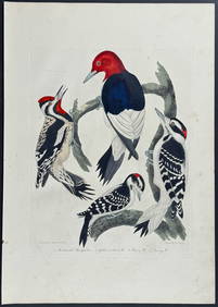
Wilson - Woodpeckers - Red-headed, Yellow-bellied, Hairy, & Downy. 9Trillium Antique Prints & Rare Books4.5(30)See Sold PriceFeb 24, 2024
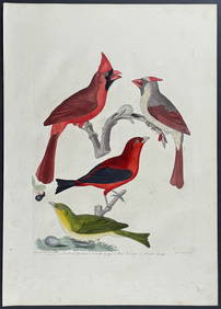
Wilson - Cardinal Grosbeak & Red Tanager. 11Trillium Antique Prints & Rare Books4.5(30)See Sold PriceFeb 24, 2024
Wilson - Mottled Owl, Lark, Creeper, & Warbler. 19Trillium Antique Prints & Rare Books4.5(30)See Sold PriceFeb 24, 2024
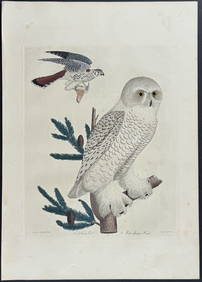
Wilson - Snow Owl (Snowy Owl) & Sparrow Hawk. 32Trillium Antique Prints & Rare Books4.5(30)See Sold PriceFeb 24, 2024
Wilson - Ivory-billed Woodpecker, Red-headed & Pileated Woodpeckers. 29Trillium Antique Prints & Rare Books4.5(30)See Sold PriceFeb 24, 2024
Wilson - Carolina Parrot & Flycatchers. 26Trillium Antique Prints & Rare Books4.5(30)See Sold PriceFeb 24, 2024
1764 Bellin Map of Eastern Guadeloupe in the Lesser Antilles -- Partie Orientale de l'Isle de laJasper524.5(9.8k)See Sold PriceFeb 27, 2024
Eastern Sahara. Africa. Libya Niger Algeria Chad Nigeria 1885 old antique mapJasper524.5(9.8k)See Sold PriceFeb 28, 2024
Reprint From The Original Coltons Map 1855 No.30 Copyright 1967Rapid Estate Liquidators and Auction Gallery4.5(1.1k)See Sold PriceFeb 29, 2024