ATLAS of ANTIENT GEOGRAPHY by SAMUEL BUTLER 1843John McInnis Auctioneers,LLC4.5(505)See Sold PriceFeb 24, 2024
18TH C. ANTIQUE MAP: FRENCH & INDIAN WAR, FRAMEDThomaston Place Auction Galleries4.4(393)See Sold PriceFeb 24, 2024
Rand McNally Railroad Map Cabinet w/ 21 Railroad MapsRail & Road Auctions4.6(165)See Sold PriceMar 08, 2024
Keith Haring - Ink on New York Map, Best Buddies, Inscribed, Signed, and DatedSapphire Auction Gallery4(67)See Sold PriceMar 02, 2024
LATE 17TH C. FRENCH MAP OF THE NEW WORLD BY ALEXIS-HUBERT JAILLOT (1632-1712)Thomaston Place Auction Galleries4.4(393)See Sold PriceFeb 24, 2024
Central Railroad of New Jersey Map of Sandy Hook Route-ca. 1903JM Hobby Supply and Railroad Artifact Auctions4.4(127)See Sold PriceFeb 24, 2024
Lot of Six Mixed Atlas Box Cars-HO Scale-New in BoxJM Hobby Supply and Railroad Artifact Auctions4.4(127)See Sold PriceFeb 25, 2024
Rand McNally/Santa Fe Railroad Map of Iowa-1912JM Hobby Supply and Railroad Artifact Auctions4.4(127)See Sold PriceFeb 24, 2024
NICOLAES VISSCHER (NETHERLANDS, 1618-1709) MAP OF THE NEW WORLDThomaston Place Auction Galleries4.4(393)See Sold PriceFeb 24, 2024
17TH C. WORLD MAP BY NICOLAES VISSCHER (NETHERLANDS, 1618-1709)Thomaston Place Auction Galleries4.4(393)See Sold PriceFeb 24, 2024
Lot of Six Mixed Atlas Cabooses-HO Scale-New in BoxJM Hobby Supply and Railroad Artifact Auctions4.4(127)See Sold PriceFeb 25, 2024
Sold1855 Colton Map of Lake Superior and the UpperTitle: 1855 Colton Map of Lake Superior and the Upper Peninsula of Michigan-- Lake Superior and the Northern Part of Michigan Cartographer: J Colton Date: 1855, New York Size: 11.8 X 15.5 in. AdditionSee Sold Price
1855 Colton Map of Lake Superior and the UpperTitle/Content of Map: 1855 Colton Map of Lake Superior and the Upper Peninsula of Michigan -- Lake Superior and the Northern Part of Michigan Date: 1855, New York Cartographer: J Colton Size: 11.8 X 1See Sold Price
Sold1855 Colton Map of Lake Superior and the Northern PartTitle: 1855 Colton Map of Lake Superior and the Northern Part of Michigan -- Lake Superior and the Northern Part of Michigan Cartographer: J Colton Year / Place: 1855, New York Map Dimension (in.): 11See Sold Price
1855 Colton Map of Lake Superior and the Northern PartTitle: 1855 Colton Map of Lake Superior and the Northern Part of Michigan -- Lake Superior and the Northern Part of Michigan Cartographer: J Colton Year / Place: 1855, New York Map Dimension (in.): 11See Sold Price
1855 Colton Map of Lake Superior and the Northern PartTitle/Content of Map: 1855 Colton Map of Lake Superior and the Northern Part of Michigan -- Lake Superior and the Northern Part of Michigan Cartographer: J Colton Year/Place: 1855, New York Size: 11.8See Sold Price
Sold[United States]. 4 Maps.[United States]. 4 Maps. ++ Lake Superior And The Northern Part Of Michigan. J. H. Colton: 1855. 11 1/2 x 13 3/4, hand-colored. Corners torn, minor edgewear, map unaffected. ++ Map Of The Central StatSee Sold Price
Sold1857 Colton Map of Lake Superior and the Northern PartReserve Reduced! Title/Content of Map: 1857 Colton Map of Lake Superior and the Northern Part of Michigan -- Lake Superior and the Northern Part of Michigan Date: 1857, New York Cartographer: J ColtonSee Sold Price
SoldColton: Antique Map of Lake Superior & Michigan, 1859Title/Content of Map: Lake Superior & UP of Michigan by Colton Date Printed: 1859 Cartographer: H. J. Colton Material/Medium: Paper Size: 17 1/2" x 15" Hand colored engraved. Published in New York inSee Sold Price
Sold1855 Colton Map of Ontario -- Canada West or UpperTitle/Content of Map: 1855 Colton Map of Ontario -- Canada West or Upper Canada Date: 1855, New York Cartographer: J Colton Size: 11.8 X 14.7 in. This is a very nice map of today's Ontario. Plenty ofSee Sold Price
SoldG.W. & C.B. Colton/ Publishers 1867G.W. & C.B. Colton/ Publishers, "Map of the Country from Lake Superior to the Pacific Ocean from the Latest Explorations and Surveys to Accompany the Report of Edwin F. Johnson Chf. Engr. Northern PacSee Sold Price
1855 Colton View of Lakes and Islands Globally --Title/Content of Map: 1855 Colton View of Lakes and Islands Globally -- Comparative Size Lakes, Islands Date: 1855, New York Cartographer: J Colton Size: 11.7 X 14.6 in. This is a great thematic map tSee Sold Price
1855 Colton View of Lakes and Islands Globally --Title/Content of Map: 1855 Colton View of Lakes and Islands Globally -- Comparative Size Lakes, Islands Cartographer: J Colton Year/Place: 1855, New York Size: 11.7 X 14.6 in. This is a great thematicSee Sold Price
1855 Colton View of Lakes and Islands Globally --Title/Content of Map: 1855 Colton View of Lakes and Islands Globally -- Comparative Size Lakes, Islands Cartographer: J Colton Year/Place: 1855, New York Size: 11.7 X 14.6 in. This is a great thematicSee Sold Price
1855 Colton View of Lakes and Islands Globally --Title/Content of Map: 1855 Colton View of Lakes and Islands Globally -- Comparative Size Lakes, Islands Cartographer: J ColtonDate: 1855, New York Size: 11.7 X 14.6 in. This is a great thematic map thSee Sold Price
SoldJ. H. Colton, "Lake Superior and the Northern Part ofJ. H. Colton, "Lake Superior and the Northern Part of Michigan, c. 1855, hand colored, H.- 13 5/8 in., W.- 16 7/8 in.See Sold Price
Sold1855 Colton Map of Asia -- AsiaTitle: 1855 Colton Map of Asia -- Asia Cartographer: J Colton Year / Place: 1855, New York Map Dimension (in.): 12.3 X 14.5 in. A very nice continental map of Asia. Plenty of topographical, river, lakSee Sold Price
1855 Colton Map of Asia -- AsiaTitle/Content of Map: 1855 Colton Map of Asia -- Asia Cartographer: J ColtonDate: 1855, New York Size: 12.3 X 14.5 in. A very nice continental map of Asia. Plenty of topographical, river, lake and citSee Sold Price
1855 Colton Map of Asia -- AsiaTitle/Content of Map: 1855 Colton Map of Asia -- Asia Date: 1855, New York Cartographer: J Colton Size: 12.3 X 14.5 in. A very nice continental map of Asia. Plenty of topographical, river, lake and ciSee Sold Price
1855 Colton Map of Asia -- AsiaTitle/Content of Map: 1855 Colton Map of Asia -- Asia Cartographer: J Colton Year/Place: 1855, New York Size: 12.3 X 14.5 in. A very nice continental map of Asia. Plenty of topographical, river, lakeSee Sold Price
1855 Colton Map of Asia -- AsiaTitle/Content of Map: 1855 Colton Map of Asia -- Asia Cartographer: J Colton Year/Place: 1855, New York Size: 12.3 X 14.5 in. A very nice continental map of Asia. Plenty of topographical, river, lakeSee Sold Price
1855 Colton Map of Asia -- AsiaTitle/Content of Map: 1855 Colton Map of Asia -- Asia Date: 1855, New York Cartographer: J Colton Size: 12.3 X 14.5 in. A very nice continental map of Asia. Plenty of topographical, river, lake and ciSee Sold Price
1855 Colton Map of Asia -- AsiaTitle: 1855 Colton Map of Asia -- Asia Date: 1855, New York Cartographer: J Colton Size:12.3 X 14.5 in. Description: A very nice continental map of Asia. Plenty of topographical, river, lake and citySee Sold Price
1855 Colton Map of Asia -- AsiaTitle: 1855 Colton Map of Asia -- Asia Cartographer: J Colton Year / Place: 1855, New York Map Dimension (in.): 12.3 X 14.5 in. A very nice continental map of Asia. Plenty of topographical, river, lakSee Sold Price
1855 Colton Map of Asia -- AsiaTitle/Content of Map: 1855 Colton Map of Asia -- Asia Date: 1855, New York Cartographer: J Colton Size: 12.3 X 14.5 in. A very nice continental map of Asia. Plenty of topographical, river, lake and ciSee Sold Price
Lake Superior and Mississippi River RR 1869 Seven Percent Bonds Book/Report-1869JM Hobby Supply and Railroad Artifact Auctions4.4(127)See Sold PriceFeb 24, 2024
Michigan Southern and Northern Indiana RR 14th Annual Report-February 28, 1869JM Hobby Supply and Railroad Artifact Auctions4.4(127)See Sold PriceFeb 24, 2024
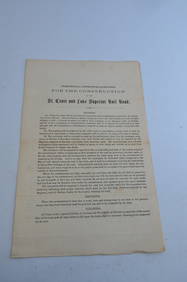
St Croix and Lake Superior RR General Specifications for Construction Document-1856JM Hobby Supply and Railroad Artifact Auctions4.4(127)See Sold PriceFeb 24, 2024
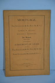
Stillwater and St Paul/Lake Superior and Mississippi RR Mortgage/Lease Agreement-1870JM Hobby Supply and Railroad Artifact Auctions4.4(127)See Sold PriceFeb 24, 2024
New York Central RR The Adirondacks Brochure 1916-1917JM Hobby Supply and Railroad Artifact Auctions4.4(127)See Sold PriceFeb 24, 2024
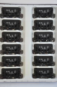
Lake Superior and Ishpeming RR 12-Pack Walthers Ore Cars-HO Scale-New in BoxJM Hobby Supply and Railroad Artifact Auctions4.4(127)See Sold PriceFeb 25, 2024
Lake Superior and Ishpeming RR 12-Pack Walthers Ore Cars-HO Scale-New in BoxJM Hobby Supply and Railroad Artifact Auctions4.4(127)See Sold PriceFeb 25, 2024
LATE 17TH C. FRENCH MAP OF THE NEW WORLD BY ALEXIS-HUBERT JAILLOT (1632-1712)Thomaston Place Auction Galleries4.4(393)See Sold PriceFeb 24, 2024
DEVINE c1856 Dr Salters Map Of Lake Huron Ontario Indian Lands etc. No. 7 ScarceLuis Porretta Fine Arts4.3(10)See Sold PriceMar 02, 2024
MATTHEWS c1856 Map Of Upper Canada Ontario Indian Land Agency Divisions Scarce!Luis Porretta Fine Arts4.3(10)See Sold PriceMar 02, 2024
19thc Colton Map, Comparitive Size of Lakes & IslandsConnoisseur Auctions3.9(336)See Sold PriceFeb 24, 2024
1853 Colton's Railroad & Township Map of Massachusetts, Rhode Island, and ConnecticutRail & Road Auctions4.6(165)See Sold PriceMar 07, 2024
1855 Map of New York & Erie Railroad and 1917 Trespassing On Railway Property Is A MisdemeanorRail & Road Auctions4.6(165)See Sold PriceMar 07, 2024
Pair of Early Railroad Maps - 1862 Pittsburgh, Ft. Wayne & Chicago Railway and 1873 PennsylvaniaRail & Road Auctions4.6(165)See Sold PriceMar 07, 2024
GEORGE ANDREW CORLEY (DATES UNKNOWN) U.S. TEAM SKI TRYOUTS / MT. HOOD OREGON. 1939.Swann Auction Galleries4.4(70)See Sold PriceFeb 29, 2024
Rare 19thc Colton Map, Argentine Republic, Chile, Uruguay, PataguayConnoisseur Auctions3.9(336)See Sold PriceMar 16, 2024
Reprint From The Original Coltons Map 1855 No.30 Copyright 1967Rapid Estate Liquidators and Auction Gallery4.5(1.1k)See Sold PriceFeb 29, 2024
ALFRED DE BREANSKI SENIOR (BRITISH 1852-1928) A PAIR OF OILS ON CANVASHutchinson Scott Auctioneers4.4(42)See Sold PriceJul 12, 2024


![[United States]. 4 Maps. (1 of 1)](https://p1.liveauctioneers.com/179/1435/617538_1_x.jpg?height=282&quality=70)