ATLAS of ANTIENT GEOGRAPHY by SAMUEL BUTLER 1843John McInnis Auctioneers,LLC4.5(505)See Sold PriceFeb 24, 2024
18TH C. ANTIQUE MAP: FRENCH & INDIAN WAR, FRAMEDThomaston Place Auction Galleries4.4(393)See Sold PriceFeb 24, 2024
Rand McNally Railroad Map Cabinet w/ 21 Railroad MapsRail & Road Auctions4.6(165)See Sold PriceMar 08, 2024
Keith Haring - Ink on New York Map, Best Buddies, Inscribed, Signed, and DatedSapphire Auction Gallery4(67)See Sold PriceMar 02, 2024
LATE 17TH C. FRENCH MAP OF THE NEW WORLD BY ALEXIS-HUBERT JAILLOT (1632-1712)Thomaston Place Auction Galleries4.4(393)See Sold PriceFeb 24, 2024
Central Railroad of New Jersey Map of Sandy Hook Route-ca. 1903JM Hobby Supply and Railroad Artifact Auctions4.4(127)See Sold PriceFeb 24, 2024
Lot of Six Mixed Atlas Box Cars-HO Scale-New in BoxJM Hobby Supply and Railroad Artifact Auctions4.4(127)See Sold PriceFeb 25, 2024
Rand McNally/Santa Fe Railroad Map of Iowa-1912JM Hobby Supply and Railroad Artifact Auctions4.4(127)See Sold PriceFeb 24, 2024
NICOLAES VISSCHER (NETHERLANDS, 1618-1709) MAP OF THE NEW WORLDThomaston Place Auction Galleries4.4(393)See Sold PriceFeb 24, 2024
17TH C. WORLD MAP BY NICOLAES VISSCHER (NETHERLANDS, 1618-1709)Thomaston Place Auction Galleries4.4(393)See Sold PriceFeb 24, 2024
Lot of Six Mixed Atlas Cabooses-HO Scale-New in BoxJM Hobby Supply and Railroad Artifact Auctions4.4(127)See Sold PriceFeb 25, 2024
Sold1850s Re-creation of 18th Century Map Showing Lower1850s Re-creation of 18th Century Map Showing Lower Manhattan Montresor, John. A Plan of the City of New York & its Environs...To the Hon'ble Tho's. Gage, Esq. Major General and Commander in Chief ofSee Sold Price
SoldPlot (R.) The Natural History of Oxford-ShirePlot (Robert) The Natural History of Oxford-Shire,second edition, 16 engraved plates, lacking folding map, damage to lower fore-corner of first gathering, 18th-century ms. note re Plot tippedSee Sold Price
Sold20th C. Re-creation of Rembrandt's 'Nightwatch'Late 20th Century re-creation of Rembrandt's famous painting 'Nightwatch', oil on canvas, showing two dozen figures in various poses in regal dress. Signed 'Willy Flores' lower right. Mounted into a mSee Sold Price
SoldAntique Oil on Canvas of Mary Magdalene ***17th / 18th Century. Mary Magdalene with partly raised arms standing by faded rendering of items on lower left. Cracks and losses as shown. As is. Photos showing views in different light. Re-lined. 28See Sold Price
Sold18TH CENTURY MAP OF LOWER SOUTH AMERICAAntique hand-colored lithograph map reads, "Carte du Chili Meridional, du Rio de la Plata des Patagons et du Detroit de Magellan Ce quii fait l'extremite Australe de L'Amerrique Merid Par le S. D'AnviSee Sold Price
SoldLarge 18th century wall map showing areas around tLarge 18th century wall map showing areas around the Caspian Sea including Persia, Sarmatia, etc. 20" x 23". Provenance: From a private Kingston NY collection.See Sold Price
Weigel: Antique Map of Southern French Antilles, 1718Insulae Antillae Franciae Inferiores A dramatic German early 18th-century map of lower French Antilles, including St. Lucia, St. Vincent and the Grenadines, Grenada, and Barbados, based on "written coSee Sold Price
1720 antique MAP of GERMANY 18th CENTURY Lower Saxony & North Rhine-WestphaliaCirculi Westphaliae in omnes suos Status et Provincias… 18th century coloured map of Lower Saxony and North Rhine-Westphalia by by Johann Baptist Homann. Shows the area between Hamburg, Cologne,See Sold Price
18th Century Map of South America18th century map “Amerique Meridionale” showing continent of South America. Measures 7.75 x 6.5”, Fine.See Sold Price
1720 antique MAP of GERMANY 18th CENTURY Lower Saxony & North Rhine-WestphaliaCirculi Westphaliae in omnes suos Status et Provincias… 18th century coloured map of Lower Saxony and North Rhine-Westphalia by by Johann Baptist Homann. Shows the area between Hamburg, Cologne,See Sold Price
1720 antique MAP of GERMANY 18th CENTURY Lower Saxony & North Rhine-WestphaliaCirculi Westphaliae in omnes suos Status et Provincias… 18th century coloured map of Lower Saxony and North Rhine-Westphalia by by Johann Baptist Homann. Shows the area between Hamburg, Cologne,See Sold Price
1720 antique MAP of GERMANY 18th CENTURY Lower Saxony & North Rhine-WestphaliaCirculi Westphaliae in omnes suos Status et Provincias… 18th century coloured map of Lower Saxony and North Rhine-Westphalia by by Johann Baptist Homann. Shows the area between Hamburg, Cologne,See Sold Price
1720 antique MAP of GERMANY 18th CENTURY Lower Saxony & North Rhine-WestphaliaCirculi Westphaliae in omnes suos Status et Provincias… 18th century coloured map of Lower Saxony and North Rhine-Westphalia by by Johann Baptist Homann. Shows the area between Hamburg, Cologne,See Sold Price
Sold18th c. Map of Northern Germany, Johann Baptist HomannsEarly 18th century map titled "Circulus Saxoniae inferioris" showing northern Germany including the cities of Berlin and Hamburg by Johann Baptist Homann published circa 1740. Framed map measures 19"See Sold Price
SoldGerman Historic War Maps, Towns, and Sieges17th and 18th Century German Cartography School, Various Maps showing Battles, Settlements, Wars at German, Swedish, and Dutch Cities, copperplate engravings, approximately 12 x 14.5 inches, approximaSee Sold Price
SoldFramed colored map of North America,Framed colored 17th/18th century map of North America, detailed map showing eastern seaboard extending to the Caribbean, the western U.S being largely uncharted with Mendocino Bay being the last northSee Sold Price
Sold18th c. Needlepoint MapNeedlepoint map, 18th century, on silk, showing Africa, Middle-East, Europe, Asia, Australia. Framed and with early matting, sight measures 15" x 15", overall with frame 20" x 20". The designation ofSee Sold Price
Sold18th Century Map of Tennessee with Native American land"Map of the Tennasee Government Formerly Part of North Carolina from the Latest Surveys, 1795," engraved by B. Tanner, published New York, J. Reid, L. Wayland & C. Smith, showing the Missisippi RiverSee Sold Price
SoldMARK TIDDEMAN (ENGLISH, 18TH CENTURY) MAP OF EASTERNMARK TIDDEMAN (ENGLISH, 18TH CENTURY) MAP OF EASTERN VIRGINIA, hand-colored, on laid paper, cartouche in lower left corner lettered "A Draught of / VIRGINIA / from the Capes of YORK in YORK RIVER andSee Sold Price
Sold18th Century Map of North AmericaOrnamental title cartouche lower right "Partie De L'Amerique Septentrionale, qui comprend Le Cours De L'Ohio, La Nlle Angleterre, La Nlle York, Le New Jersey, La Pensylvanie, Le Maryland La Virginie,See Sold Price
18th century map, North and SouthCarolina, ["Carte General de la Caroline, Dresse sur les Memoires les plus Nouveaux Par Le Sieua S…[sic]",] by Pierre Mortier, from his [Suite de Neptune Francois,] Amsterdam, 1700, showing the coasSee Sold Price
Sold18th century map of the Americas,Plate 3 of [Ocean Atlantique et Mers Adjacentes en Quatre Feuilles…] by Robert Sayer, showing southeastern North America, the Gulf of Mexico, the Caribbean Islands, and northern South America, publiSee Sold Price
SoldGrouping of 18th Century Indentures-Furnace Related.Grouping of 9 velum indentures related to Warwick and Reading Furnaces in Pennsylvania. Documents date: 1761, 1778, 1779(2), 1782(2), and 1792(3). Sold with vellum draught map showing Warwick furnaceSee Sold Price
Sold18th century map by John Overton 'A New Map of th18th century map by John Overton 'A New Map of the Kingdom of England and Principality of Wales' with twenty panels featuring views of city's, British Royal coat of arms above table showing the reignsSee Sold Price
Pennsylvania Fan Back Windsor Side ChairSchmidt's Antiques Inc. Since 19114.8(431)See Sold PriceMar 02, 2024
Ethiopian Diptych with Passion and Resurrection of ChristTimeLine Auctions Ltd.4.6(183)See Sold PriceMar 05, 2024
Large lot of assorted prints. 18th-20th century. To include: North American and other maps, CivilTremont Auctions4.5(297)See Sold PriceFeb 25, 2024
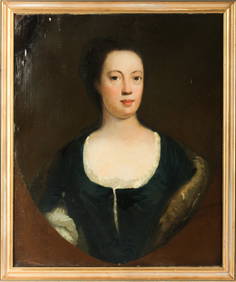
18th Century Continental School Portrait of a LadyNadeau's Auction Gallery4.7(409)See Sold PriceFeb 24, 2024
Continental School Genre Scene of a Lute PlayerNadeau's Auction Gallery4.7(409)See Sold PriceFeb 24, 2024
Mid 18th Century Exquisite Portrait Miniature in Ebonized Wood FrameHeritage Gallery Auctions4.4(60)See Sold PriceMar 10, 2024
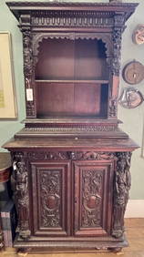
Late 18th Century Italian Rennaissance Heavily Carved Figural CabinetHeritage Gallery Auctions4.4(60)See Sold PriceMar 10, 2024
ANTIQUE FRENCH ROLLA OIL PAINTING BY HENRI GERVEXAntique Arena Inc.4.5(878)See Sold PriceFeb 24, 2024
Willem Blaeu, Etc. 17th C. Antiquarian Maps, 2Auctions at Showplace4.6(740)See Sold PriceMar 17, 2024
18th Century English School, Portrait of a Lady, Oil on Canvas PaintingHoch LTD.4.6(79)See Sold PriceFeb 25, 2024
ALBRECHT DURER (1471-1528) "THE LAMENTATION FOR CHRIST".Amelia Jeffers, Auctioneers & Appraisers4.5(120)See Sold PriceMar 07, 2024
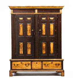
CHIPPENDALE PAINT DECORATED WARDROBE.Amelia Jeffers, Auctioneers & Appraisers4.5(120)See Sold PriceMar 08, 2024
1800 MUNGO PARK TRAVELS to AFRICA 2 VOLS w/ MAP antique in ENGLISHJasper524.5(9.9k)See Sold PriceFeb 27, 2024
Red Organic Wool Hand Knotted Antiqued Sarouk Re-Creation Oversize RugJasper524.5(9.9k)See Sold PriceFeb 28, 2024
Red Wool Hand Knotted Antiqued Fine Heris Re-Creation Round RugJasper524.5(9.9k)See Sold PriceFeb 28, 2024
Red Antiqued Fine Heris Re-Creation Hand Knotted Soft Wool Runner RugJasper524.5(9.9k)See Sold PriceFeb 28, 2024
La Basse-Guinée… Loango, Congo, AngoIa & Benguela Southern Africa BONNE 1790 mapJasper524.5(9.9k)See Sold PriceFeb 28, 2024
La Basse-Guinée… Loango, Congo, AngoIa & Benguela Southern Africa BONNE 1788 mapJasper524.5(9.9k)See Sold PriceFeb 28, 2024
Late 18th century map of England and Wales sampler and two printsFellows4.3(159)See Sold PriceMar 05, 2024
A group of seven 18th-century prints showing people and religions of IndiaIndigo Art AuctionsSee Sold PriceMar 08, 2024