ATLAS of ANTIENT GEOGRAPHY by SAMUEL BUTLER 1843John McInnis Auctioneers,LLC4.5(505)See Sold PriceFeb 24, 2024
18TH C. ANTIQUE MAP: FRENCH & INDIAN WAR, FRAMEDThomaston Place Auction Galleries4.4(393)See Sold PriceFeb 24, 2024
Rand McNally Railroad Map Cabinet w/ 21 Railroad MapsRail & Road Auctions4.6(165)See Sold PriceMar 08, 2024
Keith Haring - Ink on New York Map, Best Buddies, Inscribed, Signed, and DatedSapphire Auction Gallery4(67)See Sold PriceMar 02, 2024
LATE 17TH C. FRENCH MAP OF THE NEW WORLD BY ALEXIS-HUBERT JAILLOT (1632-1712)Thomaston Place Auction Galleries4.4(393)See Sold PriceFeb 24, 2024
Central Railroad of New Jersey Map of Sandy Hook Route-ca. 1903JM Hobby Supply and Railroad Artifact Auctions4.4(127)See Sold PriceFeb 24, 2024
Lot of Six Mixed Atlas Box Cars-HO Scale-New in BoxJM Hobby Supply and Railroad Artifact Auctions4.4(127)See Sold PriceFeb 25, 2024
Rand McNally/Santa Fe Railroad Map of Iowa-1912JM Hobby Supply and Railroad Artifact Auctions4.4(127)See Sold PriceFeb 24, 2024
NICOLAES VISSCHER (NETHERLANDS, 1618-1709) MAP OF THE NEW WORLDThomaston Place Auction Galleries4.4(393)See Sold PriceFeb 24, 2024
17TH C. WORLD MAP BY NICOLAES VISSCHER (NETHERLANDS, 1618-1709)Thomaston Place Auction Galleries4.4(393)See Sold PriceFeb 24, 2024
Lot of Six Mixed Atlas Cabooses-HO Scale-New in BoxJM Hobby Supply and Railroad Artifact Auctions4.4(127)See Sold PriceFeb 25, 2024
Sold1799 Map ITALY JOHN CARY "A New Map of Piedmont" 18th CA beautifully engraved and colored 18th Century map of Italy. This piece is entitled: "A New Map of Piedmon the Duchies of Savoy and Milan; and the Republic of Genoa; with their Subdivisions." EngraveSee Sold Price
1799 Map ITALY JOHN CARY "A New Map of Piedmont" 18th CThis is a beautifully engraved and colored 18th Century map of Italy. This piece is entitled: "A New Map of Piedmon the Duchies of Savoy and Milan; and the Republic of Genoa; with their Subdivisions."See Sold Price
Sold1799 ITALIAN PIEDMONT MAP BY CARY1799 Italian map A NEW MAP OF PIEDMONT by John Cary, published London. VG condition with some toning to paper. 19.25 x 21.25 inches plus 1" frame.See Sold Price
A New Map of Piedmont by John Cary 1799Map: A New Map of Piedmont Maker: John Cary Size: Folio - 17.75 inches high x 20.25 inches wide Date: 1799 "The Duchies of Savoy and Milan; and the Republic of Genoa; with their subdivisions." PleaseSee Sold Price
SoldCARY, FRANCE, SWISSERLAND- (2) HC ENGR,C.1800Artist: John Cary, Title: A New Map of France & New Map of Swisserland - two, Printmaker: John Cary, Pub: John Cary, Date: C.1806 & C.1799, Medium: Hand-colored engraving, Paper size: 20 1/2 x 24 eachSee Sold Price
SoldJOHN CARYA New Map of Italy, Including The Islands of Sicily, Sardinia and Corsica, with the Post Roads… 1799 Hand Colored engraving on paper Dimensions: 20" x 23" Note: "Gorgeous large format map of Italy,See Sold Price
SoldJohn Cary (British, 1754-1835) Framed Map AssortmentJohn Cary (British, 1754-1835) Framed Map Assortment c.1875, (3) maps including a 1799 'New Map of Germany,' 1804 'New Map of Europe' and 1805 'New Map of Africa' Height: 18.50 inches, Width: 21.75 inSee Sold Price
JOHN CARYA New Map of Italy, Including The Islands of Sicily, Sardinia and Corsica, with the Post Roads… 1799 Hand Colored engraving on paper Dimensions: 20" x 23" Note: "Gorgeous large format map of ItaSee Sold Price
SoldGrp: 9 Maps of New York City 18th-Early 20th c.Group of nine maps of New York City, dating from the 18th to early 20th century. By cartographers including John Montresor (1736-1799). Additionally includes a lovely 1704 map of the city featuring thSee Sold Price
SoldAFTER JOHN CARY, NEW MAP OF SUSSEX, C. 1801After John Cary (British 1754-1835), "A New Map of Sussex, Divided Into Hundreds, Exhibiting Its Roads, Rivers, Parks & C.", circa 1801, colored copper engraving, topographical map depicting the EngliSee Sold Price
SoldCary: New Map of Piedmont, 1799Title/Content of Map: New Map of Piedmont, Date Printed: 1799 Cartographer: CARY, JOHN Size (inches): x8.6 "the Duchies of Savoy and Milan; and the Republic of Genoa; with their subdivisions." PleaseSee Sold Price
SoldJohn Cary New Map of France Engraving 1799John Cary (ca. 1754–1835), "A New Map of France, Divided into Departments, as decreed by the National Assembly, MDCCXC," 1799. Hand colored engraved map of France. Dimensions: Sight; height: inSee Sold Price
SoldJohn Cary 'New map of the Principality of Wales'John Cary 'New map of the Principality of Wales' hand coloured engraving, published 1809, unframed, 47cm x 56 cm also one other map by Cary and five county maps by C & J Greenwood (7)See Sold Price
Sold18thc Map of Asia, John Senex, EnglandFramed English hand-colored engraved map by John Senex "A New Map of Asia" TITLE: A New Map of Asia from the latest Observations Most Humbly Inscrib'd to the Right Honbl. George Earl of Warrington & cSee Sold Price
SoldCARY, JOHN. A New Map of Nova Scotia, NewfoundCARY, JOHN. A New Map of Nova Scotia, Newfoundland &c. Double-page engraved map, 515x600 mm, wide margins; hand-colored. London, 1807 All items are offered for sale subject to Swann Galleries' standarSee Sold Price
Cary (John) A New Map of Nova Scotia,-. Cary (John) A New Map of Nova Scotia, Newfoundland &c., engraved map of the Gulf of St Laurence, and the coasts of Newfoundland, Nova Scotia, New Brunswick, etc., with full original hand-coSee Sold Price
John Cary: A New Map of the Circle of Bavaria, 1799By: John Cary Date: 1799 (Dated) London Dimensions: 18 x 20 inches (45.7 cm x 50.8 cm) Description: This is an authentic hand-colored antique map by the prominent cartographer John Cary, which depictsSee Sold Price
SoldMap: An 18thC hand coloured engraved map of Shropshire,Map: An 18thC hand coloured engraved map of Shropshire, after John Cary (1755-1835). Approx. 10 1/2" x 8 1/2"See Sold Price
Sold1 piece. Hand-Colored Engraved Map. Cary, John. A1 piece. Hand-Colored Engraved Map. Cary, John. A New Map of Part of The United States of North America Containing the Carolinas and Georgia, also The Floridas and Part of The Bahama Islands & C." LonSee Sold Price
SoldJohn Cary. A New Map Of America. 1806 [ca. 1808].[Cary, John/America New Map] A NEW MAP OF AMERICA, From the Latest Authorities By John Cary, Engraver. 1806. From an edition of Cary’s “New Universal Atlas.” [C. 1808. Phillis, Atlases, 714 listSee Sold Price
SoldJohn Cary. A NEW MAP OF AMERICA 1806, [ca. 1808].[New World] A NEW MAP OF AMERICA, From the Latest Authorities By John Cary, Engraver. 1806. From an edition of Cary’s “New Universal Atlas.” [C. 1808. Phillis, Atlases, 714 lists this as Plate 5See Sold Price
Sold[ITALY]. John Carey. A New Map Of Italy, Incl[ITALY]. John Carey. A New Map Of Italy, Including The Islands Of Sicily, Sardinia And Corsica With The Post Roads. Lon: 1799. Double-page engraved map, outline color. 18 x 20. Fine condition. This isSee Sold Price
Sold3 Asian maps, c. 1806[Asia]. 3 maps, double-page, outline color. Overall very good condition. ++ John Cary. A New Map Of Asia, From The Latest Authorities. Lon: 1806. 18 1/8 x 23 3/8 in. ++ Samuel Dunn. Asia, Divided IntoSee Sold Price
SoldCary Map of the Southeast, 1821, inc. AlabamaJohn Cary: A NEW MAP OF PART OF THE UNITED STATES OF NORTH AMERICA, CONTAINING THE CAROLINAS and GEORGIA, ALSO THE FLORIDAS AND PART OF THE BAHAMA ISLANDS & C., 1821. Scarce map, the only edition of CSee Sold Price
Central Railroad of New Jersey Map of Sandy Hook Route-ca. 1903JM Hobby Supply and Railroad Artifact Auctions4.4(127)See Sold PriceFeb 24, 2024
CHIPPENDALE TIGER MAPLE SLANT LID DESKThomaston Place Auction Galleries4.4(393)See Sold PriceFeb 24, 2024
LATE 18TH C. VERY LARGE CHART OF NORTHEAST CANADA BY DES BARRES (1721-1824), 1780, FRAMEDThomaston Place Auction Galleries4.4(393)See Sold PriceFeb 24, 2024
LATE 17TH C. FRENCH MAP OF THE NEW WORLD BY ALEXIS-HUBERT JAILLOT (1632-1712)Thomaston Place Auction Galleries4.4(393)See Sold PriceFeb 24, 2024
EARLY 18TH C. DUTCH CHART OF PACIFIC OCEAN BY FREDERIK DE WIT (1629-1706) WITH CALIFORNIA AS ANThomaston Place Auction Galleries4.4(393)See Sold PriceFeb 24, 2024
EARLY 18TH C. MAP OF ITALY, FRAMEDThomaston Place Auction Galleries4.4(393)See Sold PriceFeb 24, 2024
17TH C. MAP OF THE BERKSHIRES BY JOHN SPEED, FRAMEDThomaston Place Auction Galleries4.4(393)See Sold PriceFeb 24, 2024
18TH C. ANTIQUE MAP: FRENCH & INDIAN WAR, FRAMEDThomaston Place Auction Galleries4.4(393)See Sold PriceFeb 24, 2024
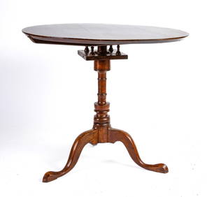
(18th c) NEW HAMPSHIRE CHERRY BIRD CAGE TEA TABLEJohn McInnis Auctioneers,LLC4.5(505)See Sold PriceFeb 25, 2024
Keith Haring - Ink on New York Map, Best Buddies, Inscribed, Signed, and DatedSapphire Auction Gallery4(67)See Sold PriceMar 02, 2024
18th C. Spanish Colonial Four Evangelist CarvingsNapoleon's Fine Art4.4(75)See Sold PriceFeb 25, 2024
Willem Blaeu, Etc. 17th C. Antiquarian Maps, 2Auctions at Showplace4.6(740)See Sold PriceMar 17, 2024
Map: A 19thC engraved and hand coloured map of Buckingham titled A New Map of BuckinghamshireClaydon Auctioneers Ltd4.3(125)See Sold PriceFeb 26, 2024
West Indies Islands. Guadaloupe. | Mariegalante &C. | Antigua.Jasper524.5(9.9k)See Sold PriceFeb 27, 2024
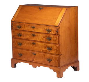
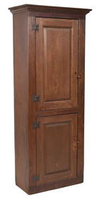
18TH C. NEW ENGLAND RED STAINED CHIMNEY CUPBOARD.William Smith Auctions4.6(147)See Sold PriceMar 06, 2024


![John Cary. A New Map Of America. 1806 [ca. 1808]. (1 of 3)](https://p1.liveauctioneers.com/179/93063/47518594_1_x.jpg?height=282&quality=70&version=1472482862)
![John Cary. A NEW MAP OF AMERICA 1806, [ca. 1808]. (1 of 3)](https://p1.liveauctioneers.com/179/82189/42599758_1_x.jpg?height=282&quality=70&version=1447864785)
![[ITALY]. John Carey. A New Map Of Italy, Incl (1 of 1)](https://p1.liveauctioneers.com/179/10971/2682742_1_x.jpg?height=282&quality=70&version=1162265652)