ATLAS of ANTIENT GEOGRAPHY by SAMUEL BUTLER 1843John McInnis Auctioneers,LLC4.6(504)See Sold PriceFeb 24, 2024
18TH C. ANTIQUE MAP: FRENCH & INDIAN WAR, FRAMEDThomaston Place Auction Galleries4.4(389)See Sold PriceFeb 24, 2024
Rand McNally Railroad Map Cabinet w/ 21 Railroad MapsRail & Road Auctions4.6(165)See Sold PriceMar 08, 2024
Keith Haring - Ink on New York Map, Best Buddies, Inscribed, Signed, and DatedSapphire Auction Gallery4.1(67)See Sold PriceMar 02, 2024
LATE 17TH C. FRENCH MAP OF THE NEW WORLD BY ALEXIS-HUBERT JAILLOT (1632-1712)Thomaston Place Auction Galleries4.4(389)See Sold PriceFeb 24, 2024
Central Railroad of New Jersey Map of Sandy Hook Route-ca. 1903JM Hobby Supply and Railroad Artifact Auctions4.4(126)See Sold PriceFeb 24, 2024
Lot of Six Mixed Atlas Box Cars-HO Scale-New in BoxJM Hobby Supply and Railroad Artifact Auctions4.4(126)See Sold PriceFeb 25, 2024
Rand McNally/Santa Fe Railroad Map of Iowa-1912JM Hobby Supply and Railroad Artifact Auctions4.4(126)See Sold PriceFeb 24, 2024
NICOLAES VISSCHER (NETHERLANDS, 1618-1709) MAP OF THE NEW WORLDThomaston Place Auction Galleries4.4(389)See Sold PriceFeb 24, 2024
17TH C. WORLD MAP BY NICOLAES VISSCHER (NETHERLANDS, 1618-1709)Thomaston Place Auction Galleries4.4(389)See Sold PriceFeb 24, 2024
Lot of Six Mixed Atlas Cabooses-HO Scale-New in BoxJM Hobby Supply and Railroad Artifact Auctions4.4(126)See Sold PriceFeb 25, 2024
Sold1787 MAP NORD ou SeptentrionAntique MAP, 1787, NORD ou Septentrion, NORD QUEST, CHOROGRAPHIE, du BAS RHIN, 17in x 11.5 black & white folded; material: paper, Shipping cost: $19, Different rate(s) to California, Alaska Hawaii andSee Sold Price
1787 MAP NORD ou SeptentrionAntique MAP, 1787, NORD ou Septentrion, NORD QUEST, CHOROGRAPHIE, du Cercle de FRANCONIE, 17in x 11.5 black & white folded; material: paper, Shipping cost: $19, Different rate(s) to California, AlaskaSee Sold Price
1787 MAP NORD ou SeptentrionAntique MAP, 1787, NORD ou Septentrion, NORD QUEST, CHOROGRAPHIE, du BAS RHIN, 17in x 11.5 black & white folded; material: paper, Shipping cost: $19, Different rate(s) to California, Alaska Hawaii andSee Sold Price
1787 MAP NORD ou SeptentrionAntique MAP, 1787, NORD ou Septentrion, NORD QUEST, CHOROGRAPHIE, du BAS RHIN, 17in x 11.5 black & white folded; material: paper, Shipping cost: $19, Different rate(s) to California, Alaska Hawaii andSee Sold Price
1787 MAP NORD ou SeptentrionAntique MAP, 1787, NORD ou Septentrion, NORD QUEST, CHOROGRAPHIE, du Cercle de FRANCONIE, 17in x 11.5 black & white folded; material: paper, Shipping cost: $19, Different rate(s) to California, AlaskaSee Sold Price
Antique map, DE HAUT RHIN 1787Antique MAP, 1787, NORD ou Septentrion, NORD QUEST, CHOROGRAPHIE, du BAS RHIN, 17in x 11.5 black & white folded; material: paper, Shipping cost: $19, Different rate(s) to California, Alaska Hawaii andSee Sold Price
Antique map, DE HAUT RHIN 1787Antique MAP, 1787, NORD ou Septentrion, NORD QUEST, CHOROGRAPHIE, du BAS RHIN, 17in x 11.5 black & white folded; material: paper, Shipping cost: $19, Different rate(s) to California, Alaska Hawaii andSee Sold Price
Sold[MAP] [ROBERT DE VAUGONDY, GILLES] Parte de la Me[MAP] [ROBERT DE VAUGONDY, GILLES] Parte de la Mer du Nord ou se trouvent Les Grandes et Las Petites Isles Antilles et les Isles Lucayes. Engraved map, partly colored by hand. 20 1/2 x 25 inches. FramSee Sold Price
La Mer du Nord où se trouvent les… Isles. Caribbean. VAUGONDY 1750 old mapTITLE OF MAP (NOT PRINTED ON THE PAGE):'Partie de la Mer du Nord, où se trouvent les Grandes et Petites Isles Antilles, et les Isles Lucayes. Par le Sr. Robert Geographe ordinaire du Roy, Avec PrSee Sold Price
La Mer du Nord où se trouvent les… Isles. Caribbean. VAUGONDY 1750 old mapTITLE OF MAP (NOT PRINTED ON THE PAGE):'Partie de la Mer du Nord, où se trouvent les Grandes et Petites Isles Antilles, et les Isles Lucayes. Par le Sr. Robert Geographe ordinaire du Roy, Avec PrSee Sold Price
La Mer du Nord où se trouvent les… Isles. Caribbean. VAUGONDY 1750 old mapTITLE OF MAP (NOT PRINTED ON THE PAGE):'Partie de la Mer du Nord, où se trouvent les Grandes et Petites Isles Antilles, et les Isles Lucayes. Par le Sr. Robert Geographe ordinaire du Roy, Avec PrSee Sold Price
SoldVAUGONDY, ROBERT DE. Partie de La Mer du NordRobert de Vaugondy, Didier. PARTIE DE LA MER DU NORD OU LE TROUVENT LES GRANDES ET PETITES ISLES ANTILLES, ET LES ISLES LUCAYES [Paris, 1784]. H. 49.5cm W. 63cm. Engraved map, hand-coloured in outlineSee Sold Price
ROBERT DE VAUGONDY, PARTIE DE LA MER DU NORD, 1784Robert de Vaugondy, Dider PARTIE DE LA MER DU NORD OU LE TROUVENT LES GRANDES ET PETITES ISLES ANTILLES, ET LES ISLES LUCAYES [Paris, 1784] H. 49.5cm W. 63cm Engraved map, hand-coloured in outline.See Sold Price
de Fer: Antique Map of Gulf of Mexico & Caribbean, 1717Title/Content of Map: "Le Golfe de Mexique, et les Provinces et Isles qui l'Environe comme sont la Floride au Nord, le Mexique ou Nouvelle Espagne a l'Ouest, la Terre-Ferme au Sud, les Is. Antilles, LSee Sold Price
SoldAN ANTIQUE MAP, "Le Golfe de Mexique," PARIS, 1717,AN ANTIQUE MAP, "Le Golfe de Mexique," PARIS, 1717, hand colored engraving on paper, "Et les Provinces et Isles qui l'Environe comme sont La Floride Au Nord Le Mexique ou Nouvelle Espagnea Al'ouest laSee Sold Price
Bonne: Oblique Projection Map Eastern Hemisphere, 1787Title/Content of Map: Eastern Hemisphere - Antique 45 Degree Northern Oblique Projection. "Mappe-Monde sur le plan Horizontal situe a 45 d. de latitude Nord. Hemisphere Oriental." Date Printed: 1787 CSee Sold Price
Mappe-monde sur un plan horisontal… à 45°N hemisphere Oriental. BONNE 1787TITLE/CONTENT OF MAP: Mappe-monde sur un plan horisontal, situé à 45 degrés de latitude Nord, hémisphère Oriental [Map of the World on a horizontal plane at 45 degrees North lSee Sold Price
SoldDIXON, GEORGE. Voyage Autour du Monde, et PrinDIXON, GEORGE. Voyage Autour du Monde, et Principalement a la Côte Nord-Ouest de l'Amérique, Fait en 1785, 1786, 1787 et 1788. 22 maps and plates, 23 folding tables. 2 volumes. 8vo, contemporary motSee Sold Price
SoldDelaporte: Antique Map of Poland Reserve, 1787Title/Content of Map: Poland Reserve Date Printed: 1787 Cartographer: Joseph Delaporte Material/Medium: Paper Size: 9 1/2" x 7 1/4" From the Atlas Ou Collection De Cartes. Geographiques Pour L'intelliSee Sold Price
Comté de Flandre. French & Belgian Flanders. Nord. VAUGONDY 1752 old mapTITLE OF MAP (NOT PRINTED ON THE PAGE):'Comté de Flandre où se trouvent distingués les Bailliages de Berg St. Winox, de Furnes, de Bourbourg, de Bailleul, et de Douay, les ChatelleniesSee Sold Price
SoldChâtelain (H A) ScandinavieChâtelain (Henri Abraham) Nouvelle Carte de Scandinavie ou des Etats du Nord,Scandinavia with part of Russia and eastern Europe, bordered with numerous coats-of-arms, engraved map with explanaSee Sold Price
SoldFramed map, Rigobert Bonne, Northeastern US, 1787Framed handcolored map, Rigobert Bonne, Carte De La Partie Nord, Des Etats Unis, de l' Amerique Septentrionale, Northeastern United States, from Raynal's ''Atlas d.les Deux Indes'', Geneva, J.L. PelleSee Sold Price
SoldSantini map of Russian discoveries in N. PacificTitle: Carte des Nouvelles Découvertes au Nord de la Mer du Sud, Tant à 'Est de la Siberie et du Kamtchatka, ou à l'Ouest de la Nouvelle France... Author: De l'Isle, Joseph Nicholas Description: CoSee Sold Price
SoldDel’Isle & Buache map of northern discoveries, 1780Heading: Author: De l'Isle, Joseph Nicholas & Philippe Buache Title: Carte des Nouvelles Découvertes au Nord de la Mer du Sud, Tant à 'Est de la Siberie et du Kamtchatka, ou à l'Ouest de la NouvelSee Sold Price
LATE 17TH C. FRENCH MAP OF THE NEW WORLD BY ALEXIS-HUBERT JAILLOT (1632-1712)Thomaston Place Auction Galleries4.4(389)See Sold PriceFeb 24, 2024
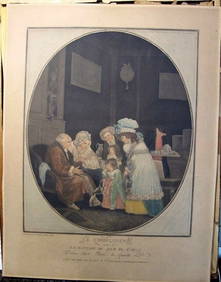
Philibert-Louis Debucourt Original Engraving Le Compliment 1787 VERY RARE!Luis Porretta Fine Arts4.3(10)See Sold PriceMar 02, 2024
RIGOBERT BONNE c1787 Original Colored Map Germany & Region 15" x 12"Luis Porretta Fine Arts4.3(10)See Sold PriceMar 02, 2024
Framed Hand Colored Antique Map of the Department of Nord, FranceDonny Malone Auctions4.4(1.8k)See Sold PriceMar 04, 2024
Duval - Pair: Map of Georgia & Map of Moscow, RussiaTrillium Antique Prints & Rare Books4.5(30)See Sold PriceFeb 24, 2024
Duval - Pair: Map of India & Map of MaldivesTrillium Antique Prints & Rare Books4.5(30)See Sold PriceFeb 24, 2024
1764 Bellin Map of Lesser Antilles Northern Portion -- Petites Antilles ou Isles du Vent 3e. Partie.Jasper524.5(9.8k)See Sold PriceFeb 27, 2024
1825 Vandermaelen Map of the Curacao, Aruba -- Amer. Sep. Curacao No. 74.Jasper524.5(9.8k)See Sold PriceFeb 27, 2024
NORTH & WEST AFRICA. Sahara Niger river 'Zaara ou le Desert'. MALLET 1683 mapJasper524.5(9.8k)See Sold PriceFeb 28, 2024
COLONIAL FRENCH NORTH AFRICA. Afrique du Nord. Politique. Political 1929 mapJasper524.5(9.8k)See Sold PriceFeb 28, 2024
Plan du Portendic, appellé aussi…' Portendick Mauritania. BELLIN 1746 old mapJasper524.5(9.8k)See Sold PriceFeb 28, 2024
Plan du Portendic, appellé aussi…' Portendick Mauritania BELLIN/SCHLEY 1747 mapJasper524.5(9.8k)See Sold PriceFeb 28, 2024
Carte de la partie septentrionale d'Afrique, ou de la Barbarie… BONNE 1780 mapJasper524.5(9.8k)See Sold PriceFeb 28, 2024
Afrique…Nord-Ouest' & 'Inde' by Meissas. N Africa India Singapore 1861 old mapJasper524.5(9.8k)See Sold PriceFeb 28, 2024
ANCIENT NORTH AFRICA. Greek colonies. "La Libye, L'Egypte…". TARDIEU 1830 mapJasper524.5(9.8k)See Sold PriceFeb 28, 2024
La Basse-Guinée… Loango, Congo, AngoIa & Benguela Southern Africa BONNE 1788 mapJasper524.5(9.8k)See Sold PriceFeb 28, 2024
L'Afrique Françoise ou du Senegal'. French West Africa. DE L’ISLE 1727 mapJasper524.5(9.8k)See Sold PriceFeb 28, 2024
Souvenirs Du Nord Ou La Guerre, La Russie Et Les Russies Ou L'Esclavage 1812 Par M. R. Faure 1821Rapid Estate Liquidators and Auction Gallery4.5(1.1k)See Sold PriceFeb 29, 2024


![[MAP] [ROBERT DE VAUGONDY, GILLES] Parte de la Me (1 of 1)](https://p1.liveauctioneers.com/292/8142/1390885_1_x.jpg?height=282&quality=70)