ATLAS of ANTIENT GEOGRAPHY by SAMUEL BUTLER 1843John McInnis Auctioneers,LLC4.5(505)See Sold PriceFeb 24, 2024
18TH C. ANTIQUE MAP: FRENCH & INDIAN WAR, FRAMEDThomaston Place Auction Galleries4.4(393)See Sold PriceFeb 24, 2024
Rand McNally Railroad Map Cabinet w/ 21 Railroad MapsRail & Road Auctions4.6(165)See Sold PriceMar 08, 2024
Keith Haring - Ink on New York Map, Best Buddies, Inscribed, Signed, and DatedSapphire Auction Gallery4(67)See Sold PriceMar 02, 2024
LATE 17TH C. FRENCH MAP OF THE NEW WORLD BY ALEXIS-HUBERT JAILLOT (1632-1712)Thomaston Place Auction Galleries4.4(393)See Sold PriceFeb 24, 2024
Central Railroad of New Jersey Map of Sandy Hook Route-ca. 1903JM Hobby Supply and Railroad Artifact Auctions4.4(127)See Sold PriceFeb 24, 2024
Lot of Six Mixed Atlas Box Cars-HO Scale-New in BoxJM Hobby Supply and Railroad Artifact Auctions4.4(127)See Sold PriceFeb 25, 2024
Rand McNally/Santa Fe Railroad Map of Iowa-1912JM Hobby Supply and Railroad Artifact Auctions4.4(127)See Sold PriceFeb 24, 2024
NICOLAES VISSCHER (NETHERLANDS, 1618-1709) MAP OF THE NEW WORLDThomaston Place Auction Galleries4.4(393)See Sold PriceFeb 24, 2024
17TH C. WORLD MAP BY NICOLAES VISSCHER (NETHERLANDS, 1618-1709)Thomaston Place Auction Galleries4.4(393)See Sold PriceFeb 24, 2024
Lot of Six Mixed Atlas Cabooses-HO Scale-New in BoxJM Hobby Supply and Railroad Artifact Auctions4.4(127)See Sold PriceFeb 25, 2024
1750 Robert de Vaugondy Map of Majority of RussianTitle: 1750 Robert de Vaugondy Map of Majority of Russian Empire -- Partie Occidentale de l'Empire de Russie, ou se Trouve Distinguee la Russie Europeenne… Cartographer: D Robert de Vaugondy Year /See Sold Price
1750 Robert de Vaugondy Map of Majority of RussianTitle: 1750 Robert de Vaugondy Map of Majority of Russian Empire -- Partie Occidentale de l'Empire de Russie, ou se Trouve Distinguee la Russie Europeenne… Cartographer: D Robert de Vaugondy Year /See Sold Price
SoldPair of maps of Russian Empire, 1750Heading: Author: Robert de Vaugondy, Gilles and Didier Title: Partie Occidentale de l'Empire de Russie, ou se trouve distinguee la Russie Europeenne... [together with] Partie Orientale de L'Empire deSee Sold Price
Pair of maps of Russian Empire, 1750Heading: Author: Robert de Vaugondy, Gilles and Didier Title: Partie Occidentale de l'Empire de Russie, ou se trouve distinguee la Russie Europeenne... [together with] Partie Orientale de L'Empire deSee Sold Price
de Vaugondy: Map of Russie Europeenne, 1750Map: Russie Europeenne Publication Date: 1750 Authors: ROBERT DE VAUGONDY, GILLES Size: Miniature – 6.80 H x 5.80 W Inches "Par le Sr. Robert de Vaugondy, avec privilege 1750." Page 336 of a seriesSee Sold Price
Royaume de Danemarck… Denmark & Southern Sweden. ROBERT DE VAUGONDY 1750 mapTITLE OF MAP (NOT PRINTED ON THE PAGE):'Royaume de Danemarck, qui comprend le Nort-Jutland divisé en fes quatre Dioceses, le Sud-Jutland divisé en ses deux Duchés, de Sleswick et de HolSee Sold Price
Antique 1757 Vaugondy Map of Russian EmpireAntique 1757 Vaugondy Map of Russian Empire. 1757 Robert De Vaugondy Large Antique Map of the Russian Empire - Poland to Asia. Antique hand colored engraving. Professionally framed and matted. MeasureSee Sold Price
SoldAntique 1757 Vaugondy Map of Russian EmpireAntique 1757 Vaugondy Map of Russian Empire. 1757 Robert De Vaugondy Large Antique Map of the Russian Empire - Poland to Asia. Antique hand colored engraving. Professionally framed and matted. MeasureSee Sold Price
Britannia Map, Robert de Vaugondy, 1750Framed hand-colored map of Britannia, by Nicolao Sanson and Robert de Vaugondy, dated 1750. Latin: Britannicae, Insula. Measures 20.75" x 22.5". Framed and matted measurement 30.25" x 31.5".See Sold Price
Amérique Méridionale. South America. ROBERT DE VAUGONDY 1750 old antique mapTITLE OF MAP (NOT PRINTED ON THE PAGE):'Amérique Méridionale, dressée, sur les Mémoires les plus récents et assujétie aux observations astronomique. Par le Sr. Robert deSee Sold Price
LARGE 18TH C MAP OF RUSSIAA FINE 18TH CENTURY MAP OF RUSSIA, 1750, ROBERT DE VAUGONDY. Partie Occidentale DE L'EMPIRE DE RUSSIE A finely engraved map with large title cartouche upper left dated 1750, original hand-colorinSee Sold Price
Robert de Vaugondy: Map of Poland With Privilege 1750Original title: Pologne par le Sr. Robert de Vaugondy. Avec Privilege 1750 Cartographer: Gilles Robert de Vaugondy 6 x 6.5 inches. Hand colored. Dated 1750 on the title, this version was published inSee Sold Price
SoldFrench Hand-Colored Map of America, 1750Antique French Hand-Colored Map of America , "Amerique Septentrionale, dressee, sur les Relations les plus modernes...", 1750, Robert de Vaugondy, the cartouche with an alligator flanked by figures, 1See Sold Price
Robert de Vaugondy: Map of Poland With Privilege 1750Original title: Pologne par le Sr. Robert de Vaugondy. Avec Privilege 1750 Cartographer: Gilles Robert de Vaugondy 6 x 6.5 inches. Hand colored. Dated 1750 on the title, this version was published inSee Sold Price
SoldRobert de Vaugondy Maps of AmericaRobert de Vaugondy (Gilles & Didier) Set of 10 Maps from the Supplement to Diderot's Encyclopedia,10 engraved folding maps, each c.300 x 380mm., the majority of American interest, modern calf,See Sold Price
SoldAmerique Septentrionale.Amerique Septentrionale. Hand-colored engraved map by Robert de Vaugondy, 1750 18.75" x 23" Frame: 29" x 33.75"See Sold Price
Sold4 Maps: 1760 N. Am.; Botanic Geo.; Eur.; OK Terr.Four Antique Maps; a French 1760 Map of North American ''AMÉRIQUE SEPTENTRIONALE...1750'' Paris: S. Robert De Vaugondy, c. 1750 (1st edition, dated in the cartouche; "Outlines of Botanical Geography"See Sold Price
Sold1750 Amerique Septentrionale dressee, sur les RelationsThis is an authentic antique map of North America by Robert De Vaugondy. The map is dated 1750, but was published in Vaugondy’s “Atlas Universal” out of Paris in 1757. This exceptioSee Sold Price
PologneTitle: Pologne Publication Date: 1750 Cartographer: ROBERT DE VAUGONDY, GILLES Size: 5.75Height - 6.3Width Additional Information: Par le Sr. Robert de Vaugondy, avec privilege 1750. Page 326 of a serSee Sold Price
SoldIsles BritanniquesTitle: Isles Britanniques Publication Date: 1750 Cartographer: ROBERT DE VAUGONDY, DIDIER Size: 5.8Height - 5.8Width Additional Information: Par le Sr. Robert de Vaugondy avec privilege 1750. Page 292See Sold Price
Suede Et Norwege.Title: Suede Et Norwege. Publication Date: 1750 Cartographer: ROBERT DE VAUGONDY, GILLES Size: 5.8Height - 5.8Width Additional Information: Par le Sr. Robert de Vaugondy, avec privilege 1750. Page 320See Sold Price
Archipel Des Indes Orientales,Title: Archipel Des Indes Orientales, Printing Date: 1750 Cartographer: ROBERT DE VAUGONDY, GILLES Publisher: LES AUTEURS ET BOUDET Size: 18.8Height - 23.25Width Additional Information: qui comprend lSee Sold Price
Provinces Unies Des Pays-BasTitle: Provinces Unies Des Pays-Bas Publication Date: 1750 Cartographer: ROBERT DE VAUGONDY, DIDIER Size: 5.75Height - 5.8Width Additional Information: Par le S. Robert de Vaugondy avec privilege du rSee Sold Price
Royaumes D'espagne Et De Portugal.Title: Royaumes D'espagne Et De Portugal. Publication Date: 1750 Cartographer: ROBERT DE VAUGONDY, DIDIER Size: 5.8Height - 5.8Width Additional Information: Par le Sr. Robert de Vaugondy avec privilegSee Sold Price
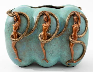
Erte "Trois Femmes" Artist Proof Bronze Bowl, 1990Auctions at Showplace4.6(740)See Sold PriceMar 03, 2024
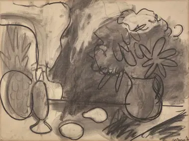
Robert De Niro, Sr. (American, 1922-1993) - Still Life with PitcherFreeman's | Hindman4.5(158)See Sold PriceFeb 28, 2024
ATTR NICOLAS DE STAEL MID 20TH C FRENCH OIL PAINTINGAntique Arena Inc.4.5(878)See Sold PriceMar 02, 2024
Buffon, Vaugody & Bell 1785 America - Map of the New ContinentAlbion Auctions4.6(341)See Sold PriceMar 01, 2024
Buffon, Vaugody & Bell 1785 Map of the Old Continent. Africa, AsiaAlbion Auctions4.6(341)See Sold PriceMar 01, 2024
SVIRIDOV GEORGY: (1915-1998)International Autograph Auctions Europe S.L.4.5(52)See Sold PriceMar 13, 2024
Robert Benard (1734 - 1777) - Set of 9 Copperplate Engravings - Greek and Roman architecture - ViewProverde Auctions4.3(3)See Sold PriceFeb 28, 2024
Robert Benard (1734 - 1777) - Set of 9 Copperplate Engravings - Architecture, Masonry, Quarry withProverde Auctions4.3(3)See Sold PriceFeb 28, 2024
Robert Benard (1734 - 1777) - Set of 9 Chemical Engravings - Alchemical symbols - Utensils forProverde Auctions4.3(3)See Sold PriceFeb 28, 2024
Robert de Vaugondy - Map of Canada - Mer de l' Ouest or Sea of the West and a Northwest PassageProverde Auctions4.3(3)See Sold PriceFeb 28, 2024
Charlie Chaplin: Collection of feuilletons about man and creativity: Chaplin as he was seen: RobertARTMAXIMUM4.3(4)See Sold PriceMar 14, 2024