ATLAS of ANTIENT GEOGRAPHY by SAMUEL BUTLER 1843John McInnis Auctioneers,LLC4.6(502)See Sold PriceFeb 24, 2024
18TH C. ANTIQUE MAP: FRENCH & INDIAN WAR, FRAMEDThomaston Place Auction Galleries4.4(386)See Sold PriceFeb 24, 2024
Rand McNally Railroad Map Cabinet w/ 21 Railroad MapsRail & Road Auctions4.6(165)See Sold PriceMar 08, 2024
Keith Haring - Ink on New York Map, Best Buddies, Inscribed, Signed, and DatedSapphire Auction Gallery4(67)See Sold PriceMar 02, 2024
LATE 17TH C. FRENCH MAP OF THE NEW WORLD BY ALEXIS-HUBERT JAILLOT (1632-1712)Thomaston Place Auction Galleries4.4(386)See Sold PriceFeb 24, 2024
Central Railroad of New Jersey Map of Sandy Hook Route-ca. 1903JM Hobby Supply and Railroad Artifact Auctions4.4(126)See Sold PriceFeb 24, 2024
Lot of Six Mixed Atlas Box Cars-HO Scale-New in BoxJM Hobby Supply and Railroad Artifact Auctions4.4(126)See Sold PriceFeb 25, 2024
Rand McNally/Santa Fe Railroad Map of Iowa-1912JM Hobby Supply and Railroad Artifact Auctions4.4(126)See Sold PriceFeb 24, 2024
NICOLAES VISSCHER (NETHERLANDS, 1618-1709) MAP OF THE NEW WORLDThomaston Place Auction Galleries4.4(386)See Sold PriceFeb 24, 2024
17TH C. WORLD MAP BY NICOLAES VISSCHER (NETHERLANDS, 1618-1709)Thomaston Place Auction Galleries4.4(386)See Sold PriceFeb 24, 2024
Lot of Six Mixed Atlas Cabooses-HO Scale-New in BoxJM Hobby Supply and Railroad Artifact Auctions4.4(126)See Sold PriceFeb 25, 2024
Sold1747 Map of Syria and AssyriaA map of "Syria and Assyria According to the Description of Ptolomy and other authors". Printed at London for John and Paul Knapton, 1747. Fine condition, the actual map measures 9.25 x 6.5", with ampSee Sold Price
SoldAntique Map SYRIA, MESOPOTAMIA, ASSYRIASize: 11 X 8.5 inches approx. Unframed. Printed 1826.See Sold Price
Antique Map SYRIA, MESOPOTAMIA, ASSYRIASize: 11 X 8.5 inches approx. Unframed. Printed 1826.See Sold Price
SoldCarey & Lea: Map of Syria, Mesopotamia, Assyria, 1832Syria, Mesopotamia, Assyria, &c. Pub. 1832 by Carey & Lea. 7 x 9. Antique hand colored map of Syria, Mesopotamia, Assyria, and other surrounding areas in the Ancient Middle East (mainly comprising modSee Sold Price
SoldTWO 19TH CENTURY MAPS OF PERSIA AND SYRIAIncludes an 1822 map of Persia by Carey and Lea, from 'The Juvenile Atlas,' professionally matted, 7.75 x 9.75 inch sight size; and an 1822 era map of Syria and Assyria, also matted, 8 x 10.25 inch siSee Sold Price
SoldMASPERO (GASTON) The Struggle of the Nations: Egypt,MASPERO (GASTON) The Struggle of the Nations: Egypt, Syria and Assyria, 1896, coloured map, plates, rebacked; with - The Dawn of Civilization, 2nd edition 1896, folding map, plates, also rebacked; LIVSee Sold Price
SoldMount & Page: Antique Map of Levant coast, 1747TITLE/CONTENT OF MAP: 'Prospects of the land upon the coasts of Cyprus and Syria' The following places are shown or referred to on the coastal profile chart: Baruti (Beirut) Sidon Cape Porcos AntiochiSee Sold Price
Bowen map of Asia Minor 1747Heading: Author: Bowen, Emanuel Title: A New and Accurate Map of Anatolia or Asia Minor with Syria and such other Provinces of the Turkish Empire as border thereupon, laid down according to the bestSee Sold Price
Bowen map of Asia Minor 1747Heading: Author: Bowen, Emanuel Title: A New and Accurate Map of Anatolia or Asia Minor with Syria and such other Provinces of the Turkish Empire as border thereupon, laid down according to the bestSee Sold Price
Bowen map of Asia Minor 1747Heading: Author: Bowen, Emanuel Title: A New and Accurate Map of Anatolia or Asia Minor with Syria and such other Provinces of the Turkish Empire as border thereupon, laid down according to the bestSee Sold Price
SoldCluverius (Philippus) Persia[Cluverius (Philippus)] Persia sive Sophorum Regnum cum Armenia, Assyria, Mesopotania et Babilonia, engraved map of part of Asia, including Armenia and Syria, 208 x 255mm., [Leiden], [1661] ?See Sold Price
SoldCanada 1747 Map. Royal or Cape Breton by Kitchin"A Map of Royal or Cape Breton from the best Authorities" by Thomas Kitchin. Copper Engraved Map Published 1732-85, London for "The London Magazine" Paper Size: 8 x 5 inch (20 x 13cm) Good ConditionSee Sold Price
Sold1747 Map of Ancient Europe Asia AfricaA Map of Europe Asia and Africa as far as they are described in Lucan's Pharsalia, published by John and Paul Knapton, London, 1747 in "Geographia Classica". 13.5" x 8" overall and map measureing 9 xSee Sold Price
Sold1747 Map of Ancient Africa EgyptA map of "Africa ex Bello Africano C I Caesaris", with inset of Egypt at the time of the Roman Empire. Printed at London by Knapton, 1747. Map measures 9.97 x 6.75" with extra wide left margin. Fine.See Sold Price
SoldNetherlands 1747 Map of Holland, Utrecht"A New & Exact Map of the Provinces of Holland, Utrecht, Gelderland, Zeeland, Dutch Flanders and Dutch Brabant" Copper Engraved Map Published 1732-85, London for "The London Magazine" Folds as issued.See Sold Price
SoldTallis, John (Pub) 1852 Map. SyriaSteel Engraved Map with Original Outline Hand Color Published 1852-56 by John Tallis, London for "The Universal Pronouncing Dictionary" by Thomas Wright. Drawn & Engraved by John Rapkin. Centre fold aSee Sold Price
SoldRare 1747 Map Belgium by Edentibus Homannianis HeredibRare 1747 Map of Belgium by Edentibus Homannianis Heredib. Well preserved color accented map of Catholic Belgium with Ten Provinces of Lower Germany made for an Atlas collection in 1747. The detailedSee Sold Price
SoldNetherlands, Belgium, Low Countries 1747 Map"A Correct Map of the Low Countries" Copper Engraved Map Published 1732-85, London for "The London Magazine" Folds as issued. Paper Size: 11 x 9 inch (28 x 23cm) Good ConditionSee Sold Price
Sold1747 Map of Expedition Alexander the GreatThe Expedition of Alexander the Great according to Quintus Curtius , Arrian, and others", published by Paul Knapton, London 1747. Fine condition. The map measures 9.5 x 6 with large margins. Fine condSee Sold Price
Sold1747 Map of the Europe Mentioned by EusebiusA Map of the places Mentioned in Eusebius's Ecelesiastical History, published by John and Paul Knapton, London, 1747 in "Geographia Classica". 13.5" x 8" overall and map measureing 9 x 6.5". Reserve:See Sold Price
Sold5V ANCIENT CIVILIZATION - ART Syria Assyria WeissThis auction lot includes the following group of titles: - Assyria by Parrot - Dated 1961 by Golden - English text, The Arts of Mankind - Assur by Parrot - Dated 1961 by Gallimard - French text, TSee Sold Price
Sold1747 Map of the Whole World Known to AncientsA Map of the Whole World as far as it was Known to the Antients, published by Paul Knapton, London 1747. Fine condition. The map measures 9.5 x 6" with large margins. Fine condition. Reserve: $50.00 SSee Sold Price
1747 Map Belgium Catholicum, Tobias Maier, HeritieTen provinces of the Catholic Inferieurs. [21 x 24 inches].See Sold Price
Sold1747 Map Roman Empire During Julius CaesarA Map of the Roman Empire as it was in the time of Julius Caesar, published by John and Paul Knapton, London, 1747 in "Geographia Classica". 13.5" x 8" overall and map measuring 9 x 6.5". Reserve: $30See Sold Price
DAVID ROBERTS - Holy Land / Syria / Egypt etc. 3 x Folio Volumes 1849 Very RareLuis Porretta Fine Arts4.3(10)See Sold PriceMar 02, 2024
Archaeological Books - Hilprecht - The Excavations in Assyria and BabyloniaTimeLine Auctions Ltd.4.5(183)See Sold PriceMar 06, 2024
West African serpents. Snake scorpion worm lizard pangolin iguana 1747 printJasper524.5(9.8k)See Sold PriceFeb 28, 2024
Partie de la Coste d'Afrique'. Southern Mauritania BELLIN/SCHLEY 1747 old mapJasper524.5(9.8k)See Sold PriceFeb 28, 2024
Carte du Golfe de Guinée'. Gulf of Guinea. Nigeria & Cameroon. BELLIN 1747 mapJasper524.5(9.8k)See Sold PriceFeb 28, 2024
Coste Occidentale d’Afrique'. Bay of Arguin, Mauritania. BELLIN/SCHLEY 1747 mapJasper524.5(9.8k)See Sold PriceFeb 28, 2024
Plan du Portendic, appellé aussi…' Portendick Mauritania BELLIN/SCHLEY 1747 mapJasper524.5(9.8k)See Sold PriceFeb 28, 2024
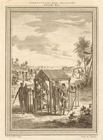
West Africa. Shrines of the Kings of Guinea, from Bry. Heads on stakes 1747Jasper524.5(9.8k)See Sold PriceFeb 28, 2024
Partie de la Coste de Guinée' Sierra Leone Liberia coast BELLIN/SCHLEY 1747 mapJasper524.5(9.8k)See Sold PriceFeb 28, 2024
Partie de la Coste de Guinée'. Sierra Leone & Liberia coast. BELLIN 1747 mapJasper524.5(9.8k)See Sold PriceFeb 28, 2024
Coste Orientale d’Afrique'. South Africa Mozambique BELLIN/SCHLEY 1747 mapJasper524.5(9.8k)See Sold PriceFeb 28, 2024
Young Crocodile, drawn in London October 1739. Sea toad. Cuttlefish. SCHLEY 1747Jasper524.5(9.8k)See Sold PriceFeb 28, 2024
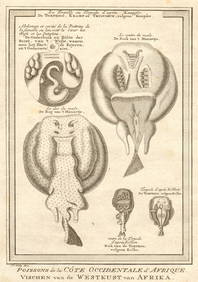
West African fish. Torpedo or electric rays after Kempfer. SCHLEY 1747 printJasper524.5(9.8k)See Sold PriceFeb 28, 2024
West Africa. Hammerhead shark. Gambian insects. Ocean Sunfish. SCHLEY 1747Jasper524.5(9.8k)See Sold PriceFeb 28, 2024
Guinea-Bissau. Negroes of Cacheu & Bissau preparing cassava. Manioc. SCHLEY 1747Jasper524.5(9.8k)See Sold PriceFeb 28, 2024
Coste d’Afrique…' Guinea-Bissau & Bissagos archipelago. BELLIN/SCHLEY 1747 mapJasper524.5(9.8k)See Sold PriceFeb 28, 2024
Cottonier & plantes de Guinée'. Cotton Cassava manioc potato. West Africa 1747Jasper524.5(9.8k)See Sold PriceFeb 28, 2024
Suite de la Coste de Guinée'. Ghana Togo Benin coast. Whidah. BELLIN 1747 mapJasper524.5(9.8k)See Sold PriceFeb 28, 2024