ATLAS of ANTIENT GEOGRAPHY by SAMUEL BUTLER 1843John McInnis Auctioneers,LLC4.6(504)See Sold PriceFeb 24, 2024
18TH C. ANTIQUE MAP: FRENCH & INDIAN WAR, FRAMEDThomaston Place Auction Galleries4.4(389)See Sold PriceFeb 24, 2024
Rand McNally Railroad Map Cabinet w/ 21 Railroad MapsRail & Road Auctions4.6(165)See Sold PriceMar 08, 2024
Keith Haring - Ink on New York Map, Best Buddies, Inscribed, Signed, and DatedSapphire Auction Gallery4.1(67)See Sold PriceMar 02, 2024
LATE 17TH C. FRENCH MAP OF THE NEW WORLD BY ALEXIS-HUBERT JAILLOT (1632-1712)Thomaston Place Auction Galleries4.4(389)See Sold PriceFeb 24, 2024
Central Railroad of New Jersey Map of Sandy Hook Route-ca. 1903JM Hobby Supply and Railroad Artifact Auctions4.4(126)See Sold PriceFeb 24, 2024
Lot of Six Mixed Atlas Box Cars-HO Scale-New in BoxJM Hobby Supply and Railroad Artifact Auctions4.4(126)See Sold PriceFeb 25, 2024
Rand McNally/Santa Fe Railroad Map of Iowa-1912JM Hobby Supply and Railroad Artifact Auctions4.4(126)See Sold PriceFeb 24, 2024
NICOLAES VISSCHER (NETHERLANDS, 1618-1709) MAP OF THE NEW WORLDThomaston Place Auction Galleries4.4(389)See Sold PriceFeb 24, 2024
17TH C. WORLD MAP BY NICOLAES VISSCHER (NETHERLANDS, 1618-1709)Thomaston Place Auction Galleries4.4(389)See Sold PriceFeb 24, 2024
Lot of Six Mixed Atlas Cabooses-HO Scale-New in BoxJM Hobby Supply and Railroad Artifact Auctions4.4(126)See Sold PriceFeb 25, 2024
SoldCanada 1747 Map. Royal or Cape Breton by Kitchin"A Map of Royal or Cape Breton from the best Authorities" by Thomas Kitchin. Copper Engraved Map Published 1732-85, London for "The London Magazine" Paper Size: 8 x 5 inch (20 x 13cm) Good ConditionSee Sold Price
Colton's North Eastern Canada MapCirca 1855 Antique Canada Map, Title: Colton's New Brunswick, Nova Scotia, Prince Edward Id., and Cape Breton Id. Published by: J. H. Colton of NY in 1855, Approximate size: 18-1/2" x 26". Map folds aSee Sold Price
SoldBellin/Jefferys: Antique Map of Canada & Islands, 1746Map: A new chart of the coast of New England, Nova Scotia, New France or Canada, with the islands of Newfoundl’d. Cape Breton, St. John’s &c. Publication Date: 1746 Authors: Gentleman’s MagazineSee Sold Price
Sold1764 Hand Colored Map Acadia Canada Jacques Bellin“Carte de l'Acadie et Pays Voisins…”, a map of the portion of Canada including Cape Breton and Cape Sable. Handcolored. By Jacques Bellin, Paris, 1764. Very Good, measures 16 x 10.5”. Please nSee Sold Price
Dominion of Canada (East). Maritimes. Newfoundland.TITLE/CONTENT OF MAP: 'Dominion of Canada (Eastern Sheet) showing New Brunswick, & Nova Scotia, with Prince Edward Id Cape Breton Id and Newfoundland [inset: Newfoundland]' DATE PRINTED: 1879 IMAGE SISee Sold Price
Sold1778 Zatta Newfoundland & Cape Breton1778 Antonio Zatta, Venizia, "Le isole di Terra Nova e Capo Breton" (Newfoundland & Cape Breton, Canada), hand colored 2 sheet map, salted cod vignette, plate size 17 1/2" x 13 1/2", overall size 19 1See Sold Price
SoldKitchin: Antique Map of Cape de Verde Islands, 1747Title of the Map: 'A Map or Chart of the Cape de Verde Islands' Cape Verde islands - Cabo Verde - Santo Antão - São Vicente - Santa Luzia - São Nicolau - Sal - Boa Vista - Maio - Santiago - Fogo -See Sold Price
Map of North America Plus CanadaNorth America PLUS The Dominion of Canada with Nova Scotia Prince Edward Island and Cape Breton Island insert map and Newfoundland insert map Two maps on one sSee Sold Price
Map of North America Plus CanadaNorth America PLUS The Dominion of Canada with Nova Scotia Prince Edward Island and Cape Breton Island insert map and Newfoundland insert map Two maps on one sSee Sold Price
Map of North America Plus CanadaNorth America PLUS The Dominion of Canada with Nova Scotia Prince Edward Island and Cape Breton Island insert map and Newfoundland insert map Two maps on one sheet. (backSee Sold Price
Map of North America Plus CanadaNorth America PLUS The Dominion of Canada with Nova Scotia Prince Edward Island and Cape Breton Island insert map and Newfoundland insert map Two maps on one sSee Sold Price
Map of North America Plus CanadaNorth America PLUS The Dominion of Canada with Nova Scotia Prince Edward Island and Cape Breton Island insert map and Newfoundland insert map Two maps on one sheet. (back toSee Sold Price
SoldMap of North America Plus CanadaNorth America PLUS The Dominion of Canada with Nova Scotia Prince Edward Island and Cape Breton Island insert map and Newfoundland insert map Two maps on one sheetSee Sold Price
Map of North America Plus CanadaNorth America PLUS The Dominion of Canada with Nova Scotia Prince Edward Island and Cape Breton Island insert map and Newfoundland insert map Two maps on one sSee Sold Price
Map of North America Plus CanadaNorth America PLUS The Dominion of Canada with Nova Scotia Prince Edward Island and Cape Breton Island insert map and Newfoundland insert map Two maps on one sheet. (backSee Sold Price
SoldLarge Map of Nova Scotia, 1786Jefferys, Thomas. "A New Map of Nova Scotia, and Cape Breton Island with the adjacent parts of New England and Canada…. " London, Printed and sold by R. Saver, Map Seller, 1 Aug. 1786. Measured fromSee Sold Price
SoldJefferys New Map of Nova ScotiaA New Map of Nova Scotia, and Cape Breton Island with the Adjacent Parts of New England and Canada... Thomas Jefferys (1719-1771). Engraved map with hand color in outline. London, 1775. 18 3/4 x 24 1/See Sold Price
The Cape De Verde Islands Map, Thomas Kitchin, 1747TITLE OF THE MAP: 'A Map or Chart of the Cape de Verde Islands' Cape Verde islands - Cabo Verde - Santo Antão - São Vicente - Santa Luzia - São Nicolau - Sal - Boa Vista - Maio - Santiago - Fogo -See Sold Price
SoldAmerica.- Bowen (Emanuel) A New & Accurate Map ofAmerica.- Bowen (Emanuel) A New & Accurate Map of Louisiana, with Part of Florida and Canada, and the Adjacent Countries; A New & Accurate Map of the Islands of Newfoundland, Cape Breton, St. John andSee Sold Price
SoldNova Scotia and Cape Breton. Thomas Jeffreys (1719Nova Scotia and Cape Breton. Thomas Jeffreys (1719-1771) A New Map of Nova Scotia and Cape Britain with the adjacent parts of New England and Canada. London, c. 1755. Engraved hand-colored map, printeSee Sold Price
SoldCanada.- Gibson (John) A New and Correct Map of theCanada.- Gibson (John) A New and Correct Map of the Isles of New Found Land, Cape Breton &c., with the Provinces of Nova Scotia, engraved map on laid paper with watermark of a crown and the initials GSee Sold Price
Sold18th C. Hand-Colored Map of New EnglandAn 18th C. hand-colored engraved map of New England, Nova Scotia, New France, or Canada, with the Islands of Newfoundland, Cape Breton, St. John's, by Jacques-Nicholas Bellin. Framed under glass. MatSee Sold Price
Map of Nova Scotia, New Brunswick, Prince Edward IslandTitle/Content of Map: Map of Nova Scotia, New Brunswick, Prince Edward Island And Cape Breton (Dominion of Canada) 1905 Date Printed: 1905 Cartographer: ANONYMOUS Size: 17X22.6 "Prepared under directiSee Sold Price
Dominion of Canada (Eastern Sheet) Comprising NewTitle: Dominion of Canada (Eastern Sheet) Comprising New Brunswick, Nova Scotia, Prince Edward Id. & Cape Breton Id. With Newfoundland | Newfoundland Publication Date: 1888 Cartographer: BRADLEY, WM.See Sold Price
1875 Rand Avery and Co. Map of Express Companies and Railroads of the USA and CanadaJM Hobby Supply and Railroad Artifact Auctions4.4(126)See Sold PriceFeb 24, 2024
LATE 18TH C. VERY LARGE CHART OF NORTHEAST CANADA BY DES BARRES (1721-1824), 1780, FRAMEDThomaston Place Auction Galleries4.4(389)See Sold PriceFeb 24, 2024
Map UNITED COUNTIES LEEDS & GRENVILLE by Walling 1861 Rare Canada Map 5ft x 5ftLuis Porretta Fine Arts4.3(10)See Sold PriceMar 02, 2024
MATTHEWS c1856 Map Of Upper Canada Ontario Indian Land Agency Divisions Scarce!Luis Porretta Fine Arts4.3(10)See Sold PriceMar 02, 2024
Hiroshi Sugimoto - North Atlantic Ocean, Cape Breton IslandSapphire Auction Gallery4.1(67)See Sold PriceMar 02, 2024
Nostalgia #386 Cape Breton Highlanders of 1894Old Toy Soldier Auctions USA4.8(1.1k)See Sold PriceMar 15, 2024
[MAP]. [ALBRIZZI, Giambatista, 1698-1777]. Carta Geografica...Potter & Potter Auctions4.6(544)See Sold PriceMar 07, 2024
2023 Royal Canadian Mint Canada Maple Leaf 1g. 9999 Fine Gold RoundMatthew Bullock Auctioneers4.7(1.8k)See Sold PriceFeb 24, 2024
Coast & Islands between Cape Roxo. Guinea-Bissau & Bissagos. KITCHIN 1745 mapJasper524.5(9.8k)See Sold PriceFeb 28, 2024
Carte du Golfe de Guinée'. Gulf of Guinea. Nigeria & Cameroon. BELLIN 1747 mapJasper524.5(9.8k)See Sold PriceFeb 28, 2024
Coste Occidentale d’Afrique'. Bay of Arguin, Mauritania. BELLIN/SCHLEY 1747 mapJasper524.5(9.8k)See Sold PriceFeb 28, 2024
Partie de la Coste de Guinée' Sierra Leone Liberia coast BELLIN/SCHLEY 1747 mapJasper524.5(9.8k)See Sold PriceFeb 28, 2024
Partie de la Coste de Guinée'. Sierra Leone & Liberia coast. BELLIN 1747 mapJasper524.5(9.8k)See Sold PriceFeb 28, 2024
Guinea-Bissau. Cacheu town & Fortaleza de São José da Amura. SCHLEY 1747 printJasper524.5(9.8k)See Sold PriceFeb 28, 2024
Coste Orientale d’Afrique'. South Africa Mozambique BELLIN/SCHLEY 1747 mapJasper524.5(9.8k)See Sold PriceFeb 28, 2024
West African birds. Kurbalot Fisher Aigret Bustard Damsel Monoceros 1747 printJasper524.5(9.8k)See Sold PriceFeb 28, 2024
Coste d’Afrique…' Guinea-Bissau & Bissagos archipelago. BELLIN/SCHLEY 1747 mapJasper524.5(9.8k)See Sold PriceFeb 28, 2024
Churchill & Nieuhof 1744 Folio Map. Cape of Good Hope, South AfricaAlbion Auctions4.6(341)See Sold PriceMar 01, 2024
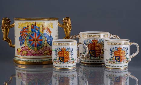
GROUP OF BRITISH ROYAL PORCELAIN MEMORABILIAPridham's Auctions & Appraisals4.7(223)See Sold PriceMar 02, 2024
JOYCE WIELAND: TRUE PATRIOT LOVE. 1971, 1st. ED.Toronto Book Auctions4.3(13)See Sold PriceMar 07, 2024
RMC ROYAL MILITARY COLLEGE. 8 BOOKS SOLD TOGETHER.Toronto Book Auctions4.3(13)See Sold PriceMar 07, 2024
Robert de Vaugondy - Map of Canada - Mer de l' Ouest or Sea of the West and a Northwest PassageProverde Auctions4.3(3)See Sold PriceFeb 28, 2024


![[MAP]. [ALBRIZZI, Giambatista, 1698-1777]. Carta Geografica... (1 of 1)](https://p1.liveauctioneers.com/928/318880/171361280_1_x.jpg?height=282&quality=70&version=1707501302)