ATLAS of ANTIENT GEOGRAPHY by SAMUEL BUTLER 1843John McInnis Auctioneers,LLC4.5(505)See Sold PriceFeb 24, 2024
18TH C. ANTIQUE MAP: FRENCH & INDIAN WAR, FRAMEDThomaston Place Auction Galleries4.4(393)See Sold PriceFeb 24, 2024
Rand McNally Railroad Map Cabinet w/ 21 Railroad MapsRail & Road Auctions4.6(165)See Sold PriceMar 08, 2024
Keith Haring - Ink on New York Map, Best Buddies, Inscribed, Signed, and DatedSapphire Auction Gallery4(67)See Sold PriceMar 02, 2024
LATE 17TH C. FRENCH MAP OF THE NEW WORLD BY ALEXIS-HUBERT JAILLOT (1632-1712)Thomaston Place Auction Galleries4.4(393)See Sold PriceFeb 24, 2024
Central Railroad of New Jersey Map of Sandy Hook Route-ca. 1903JM Hobby Supply and Railroad Artifact Auctions4.4(127)See Sold PriceFeb 24, 2024
Lot of Six Mixed Atlas Box Cars-HO Scale-New in BoxJM Hobby Supply and Railroad Artifact Auctions4.4(127)See Sold PriceFeb 25, 2024
Rand McNally/Santa Fe Railroad Map of Iowa-1912JM Hobby Supply and Railroad Artifact Auctions4.4(127)See Sold PriceFeb 24, 2024
NICOLAES VISSCHER (NETHERLANDS, 1618-1709) MAP OF THE NEW WORLDThomaston Place Auction Galleries4.4(393)See Sold PriceFeb 24, 2024
17TH C. WORLD MAP BY NICOLAES VISSCHER (NETHERLANDS, 1618-1709)Thomaston Place Auction Galleries4.4(393)See Sold PriceFeb 24, 2024
Lot of Six Mixed Atlas Cabooses-HO Scale-New in BoxJM Hobby Supply and Railroad Artifact Auctions4.4(127)See Sold PriceFeb 25, 2024
Sold1721 Senex Map of the Atlantic Side of Panama -- ATitle/Content of Map: 1721 Senex Map of the Atlantic Side of Panama -- A Draft of the Golden & Adjacent Islands, with part of ye Isthmus of Darien as it was taken by Capt. Ieneser. Where ye Scots WestSee Sold Price
1721 Senex Map of the Atlantic Side of Panama -- ATitle/Content of Map: 1721 Senex Map of the Atlantic Side of Panama -- A Draft of the Golden & Adjacent Islands, with part of ye Isthmus of Darien as it was taken by Capt. Ieneser. Where ye Scots WestSee Sold Price
1721 Senex Map of the Atlantic Side of Panama -- ATitle/Content of Map: 1721 Senex Map of the Atlantic Side of Panama -- A Draft of the Golden & Adjacent Islands, with part of ye Isthmus of Darien as it was taken by Capt. Ieneser. Where ye Scots WestSee Sold Price
1721 Senex Map of British Caribbean Islands -- A NewTitle/Content of Map: 1721 Senex Map of British Caribbean Islands -- A New Map of the English Empire in the Ocean of America or West Indies Date: 1721, London Cartographer: J Senex Size: 20.1 X 23.8 iSee Sold Price
1721 Senex Map of British Caribbean Islands -- A NewTitle/Content of Map: 1721 Senex Map of British Caribbean Islands -- A New Map of the English Empire in the Ocean of America or West Indies Date: 1721, London Cartographer: J Senex Size: 20.1 X 23.8 iSee Sold Price
1721 Senex Map of British Caribbean Islands -- A NewTitle/Content of Map: 1721 Senex Map of British Caribbean Islands -- A New Map of the English Empire in the Ocean of America or West Indies Date: 1721, London Cartographer: J Senex Size: 20.1 X 23.8 iSee Sold Price
Sold1721 Senex Map of British Caribbean Islands -- A NewTitle/Content of Map: 1721 Senex Map of British Caribbean Islands -- A New Map of the English Empire in the Ocean of America or West Indies Date: 1721, London Cartographer: J Senex Size: 20.1 X 23.8 iSee Sold Price
1721 Senex Map of British Caribbean Islands -- A NewTitle/Content of Map: 1721 Senex Map of British Caribbean Islands -- A New Map of the English Empire in the Ocean of America or West Indies Date: 1721, London Cartographer: J Senex Size: 20.1 X 23.8 iSee Sold Price
1721 Senex Map of British Caribbean Islands -- A NewTitle/Content of Map: 1721 Senex Map of British Caribbean Islands -- A New Map of the English Empire in the Ocean of America or West Indies Date: 1721, London Cartographer: J Senex Size: 20.1 X 23.8 iSee Sold Price
1721 Senex Map of British Caribbean Islands -- A NewTitle: 1721 Senex Map of British Caribbean Islands -- A New Map of the English Empire in the Ocean of America or West Indies Date: 1721, London Cartographer: J Senex Size: 20.1 X 23.8 in. Additional ISee Sold Price
1721 Senex Map of British Caribbean Islands -- A NewTitle/Content of Map: 1721 Senex Map of British Caribbean Islands -- A New Map of the English Empire in the Ocean of America or West Indies Date: 1721, London Cartographer: J Senex Size: 20.1 X 23.8 iSee Sold Price
1721 Senex Map of British Caribbean Islands -- A NewTitle/Content of Map: 1721 Senex Map of British Caribbean Islands -- A New Map of the English Empire in the Ocean of America or West Indies Date: 1721, London Cartographer: J Senex Size: 20.1 X 23.8 iSee Sold Price
1721 Senex Map of Sicily and Malta -- A Map of theTitle/Content of Map: 1721 Senex Map of Sicily and Malta -- A Map of the Island and Kingdom of Sicily from the Latest Observations Cartographer: J Senex Year/Place: 1721, London Size: 19 X 23 in. ThisSee Sold Price
1721 Senex Map of Sicily and Malta -- A Map of theTitle/Content of Map: 1721 Senex Map of Sicily and Malta -- A Map of the Island and Kingdom of Sicily from the Latest Observations Cartographer: J Senex Year/Place: 1721, London Size: 19 X 23 in. ThisSee Sold Price
1721 Senex Map of Sicily and Malta -- A Map of theTitle: 1721 Senex Map of Sicily and Malta -- A Map of the Island and Kingdom of Sicily from the Latest Observations Cartographer: J Senex Year / Place: 1721, London Map Dimension (in.): 19 X 23 in. ThSee Sold Price
1721 Senex Map of Sicily and Malta -- A Map of theTitle/Content of Map: 1721 Senex Map of Sicily and Malta -- A Map of the Island and Kingdom of Sicily from the Latest Observations Cartographer: J Senex Year/Place: 1721, London Size: 19 X 23 in. ThisSee Sold Price
1721 Senex Map of Sicily and Malta -- A Map of theTitle/Content of Map: 1721 Senex Map of Sicily and Malta -- A Map of the Island and Kingdom of Sicily from the Latest Observations Date: 1721, London Cartographer: J Senex Size: 19 X 23 in. This is aSee Sold Price
1721 Senex Map of Sicily and Malta -- A Map of theTitle: 1721 Senex Map of Sicily and Malta -- A Map of the Island and Kingdom of Sicily from the Latest Observations Cartographer: J Senex Year/Place: 1721, London Map Dimensions (in.): 19 X 23 in. DesSee Sold Price
1721 John Senex Map of the WorldItem: 1721 John Senex Map of the World Description: John Senex Map of the World Dimensions: 17 x 21.5 in Please note that this lot has a confidential reserve. When you leave a bid in advance of the auSee Sold Price
SoldJohn Senex, "Map of Louisiana", 1721John Senex, "A Map of Louisiana and the River Mississippi", 1721, London, copper-plate engraved map, laid paper, watermarked with a fleur-de-lis and "HD", the map with interesting nomenclature of "ProSee Sold Price
SoldEngraved Map of Maine Coastline by Des BarresCoast of Maine showing Blue Hill Bay, Penobscot Bay, Belfast Bay, Islesboro Island, Deer Island, and other islands. Joseph Frederick Willet Des Barres (1721-1824). Engraved Map from the Atlantic NeptuSee Sold Price
SoldMap of Italy by John Senex 1721Heading: Author: Senex, John Title: Italy Distinguished According to the Extent of all the States, Kingdomes, Republicks, Dukedoms, Principalities &c. that do at Present Divide it... Revised by I. SeSee Sold Price
SoldJohn Senex Map of North and South America 1719-17John Senex (1678–1740), "A New Map of America from the Latest Observations," London, ca. 1719-1721. Hand colored copperplate engraved map of North and South America, from Senex's "New General ASee Sold Price
SoldJohn Senex, MapJohn Senex, "A Map of Louisiana and of the River Mississipi", London, 1721, famously plagiarized from Delisle's original 1718 map, mounted on board, framed, 19 in. x 23 in.,See Sold Price
Hammonds Map of Kentucky and Tennessee Railroads-1910JM Hobby Supply and Railroad Artifact Auctions4.4(127)See Sold PriceFeb 24, 2024
Kenyons Pocket Map and Shippers Guide of Wisconsin-1914JM Hobby Supply and Railroad Artifact Auctions4.4(127)See Sold PriceFeb 24, 2024
Map of Missouri Highways and Railroads-1921JM Hobby Supply and Railroad Artifact Auctions4.4(127)See Sold PriceFeb 24, 2024
Northern Pacific RR Washington and Northern Idaho Map Folder-1941JM Hobby Supply and Railroad Artifact Auctions4.4(127)See Sold PriceFeb 24, 2024
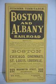
Boston and Albany RR March 17, 1881 Public TimetableJM Hobby Supply and Railroad Artifact Auctions4.4(127)See Sold PriceFeb 24, 2024
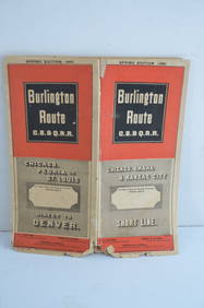
Chicago Burlington and Quincy RR Spring 1885 Public TimetableJM Hobby Supply and Railroad Artifact Auctions4.4(127)See Sold PriceFeb 24, 2024
Chicago Burlington and Quincy RR Spring 1890 Public TimetableJM Hobby Supply and Railroad Artifact Auctions4.4(127)See Sold PriceFeb 24, 2024
Chicago Burlington and Quincy RR February 5, 1892 Public TimetableJM Hobby Supply and Railroad Artifact Auctions4.4(127)See Sold PriceFeb 24, 2024
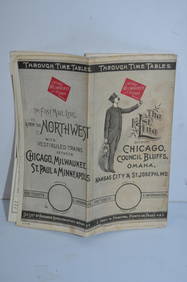
Chicago Milwaukee and St Paul RY March 1, 1889 Public TimetableJM Hobby Supply and Railroad Artifact Auctions4.4(127)See Sold PriceFeb 24, 2024
New York Central and Hudson River RR Public Timetable-November 3, 1901JM Hobby Supply and Railroad Artifact Auctions4.4(127)See Sold PriceFeb 24, 2024
Pennsylvania Central/Pittsburgh Ft Wayne and Chicago 1870 Public TimetableJM Hobby Supply and Railroad Artifact Auctions4.4(127)See Sold PriceFeb 24, 2024
Pennsylvania Railroad May 29, 1904 Public TimetableJM Hobby Supply and Railroad Artifact Auctions4.4(127)See Sold PriceFeb 24, 2024
Jerusalem Map for British Soldiers in Palestine - WW2Levy Auction House4.3(11)See Sold PriceFeb 27, 2024
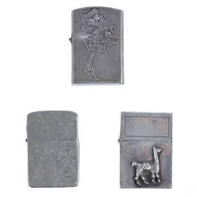
Vietnam War Era Silver Cigarette Lighters 3pc LOTHill Auction Gallery 4.7(1k)See Sold PriceFeb 28, 2024
Group of 15 Printed or Lithographed Items, including: litho...Potter & Potter Auctions4.6(545)See Sold PriceMar 07, 2024
3PC Royal Bayreuth Porcelain Flower CreamersBruneau & Co. Auctioneers4.5(491)See Sold PriceMar 18, 2024
John Senex Map of Louisiana & Mississippi RiverWillow Auction House4.5(289)See Sold PriceMar 14, 2024