ATLAS of ANTIENT GEOGRAPHY by SAMUEL BUTLER 1843John McInnis Auctioneers,LLC4.6(502)See Sold PriceFeb 24, 2024
18TH C. ANTIQUE MAP: FRENCH & INDIAN WAR, FRAMEDThomaston Place Auction Galleries4.4(386)See Sold PriceFeb 24, 2024
Rand McNally Railroad Map Cabinet w/ 21 Railroad MapsRail & Road Auctions4.6(165)See Sold PriceMar 08, 2024
Keith Haring - Ink on New York Map, Best Buddies, Inscribed, Signed, and DatedSapphire Auction Gallery4(67)See Sold PriceMar 02, 2024
LATE 17TH C. FRENCH MAP OF THE NEW WORLD BY ALEXIS-HUBERT JAILLOT (1632-1712)Thomaston Place Auction Galleries4.4(386)See Sold PriceFeb 24, 2024
Central Railroad of New Jersey Map of Sandy Hook Route-ca. 1903JM Hobby Supply and Railroad Artifact Auctions4.4(126)See Sold PriceFeb 24, 2024
Lot of Six Mixed Atlas Box Cars-HO Scale-New in BoxJM Hobby Supply and Railroad Artifact Auctions4.4(126)See Sold PriceFeb 25, 2024
Rand McNally/Santa Fe Railroad Map of Iowa-1912JM Hobby Supply and Railroad Artifact Auctions4.4(126)See Sold PriceFeb 24, 2024
NICOLAES VISSCHER (NETHERLANDS, 1618-1709) MAP OF THE NEW WORLDThomaston Place Auction Galleries4.4(386)See Sold PriceFeb 24, 2024
17TH C. WORLD MAP BY NICOLAES VISSCHER (NETHERLANDS, 1618-1709)Thomaston Place Auction Galleries4.4(386)See Sold PriceFeb 24, 2024
Lot of Six Mixed Atlas Cabooses-HO Scale-New in BoxJM Hobby Supply and Railroad Artifact Auctions4.4(126)See Sold PriceFeb 25, 2024
16th C. Map "Cite De Saintes" by Braun & HogenbergStriking; Colorful Map Entitled "Cite De Saintes" from the important Civitates Orbis Terrarum (volume 7) by the renowned and respected Georg Braun and Franz Hogenberg | Map is a bird's-eye view of SaiSee Sold Price
16th Century Map Entitled "Cite De Saintes" From theStriking & Colorful Map Entitled "Cite De Saintes" from the important Civitates Orbis Terrarum (volume 7)by the renowned and respected Georg Braun and Franz Hogenberg | Map is a bird's-eye view ofSee Sold Price
Map Entitled "Cite De Saintes " By Braun & HogenbergStriking & Colorful Antique Map Entitled "Cite De Saintes" from the important Civitates Orbis Terrarum (volume 7)by the renowned and respected Georg Braun and Franz Hogenberg | Map is a bird's-eye vieSee Sold Price
SoldCity Saintes Antique MapCite De Saintes (bird's-eye view of Saintes by Braun and Hogenberg, made after a drawing by Georg Hoefnagel ca. 1596). Hand-colored engraving, possibly from a later printing. Sight size 19 x 15.25 incSee Sold Price
Sold16th C Map of Mexico, Cusco, Peru, Braun Hogenberg16th C Hand Colored Aerial Map, etching of Mexico City, Cusco, Braun and Hogenberg. Written insets: Mexico, Regia et Celebris Hispaniae Novae Civitas - Cusco, Regni Peru in Novo Orbe Caput. Authors BRSee Sold Price
BRAUN & HOGENBERG 16TH C. MAP OF NIMES & BORDEAUXGEORG BRAUN & FRANS HOGENBERG FRAMED 16TH C. MAP OF NIMES & BORDEAUX Map engraving by Georg Braun and Frans Hogenberg, of the French cities of Nimes and Bordeaux. Set in a wooden frame under glass. CiSee Sold Price
SoldGEORG BRAUN & FRANS HOGENBERG FRAMED 16TH C. MAPGEORG BRAUN & FRANS HOGENBERG FRAMED 16TH C. MAP Map engraving by Georg Braun and Frans Hogenberg, of the French cities of Nimes and Bordeaux. Set in a wooden frame under glass. Circa 16th century.&nbSee Sold Price
Sold2 hand-Colored 16th C. maps: Verona, Florence...Braun & Hogenberg. 2 hand-colored city views. ++ ''Hae Est Nobilis, & Florens Illa Neapolis, Campa nice ciuitas, antea Parthenope appellata...'' Birds-eye view of Naples' streets and buildings, shipsSee Sold Price
SoldRotterdam and Gouda, hand-colored map, 16th c.Rotterdam and Gouda, hand-colored map, 16th c., "Roterodamum Hollandiae Opp." and "Gouda", G. Braun and F. Hogenberg, hand-colored engraving on paper, 15"h x 19.25"w (sight), 22"h x 26.5"w (frame)See Sold Price
Sold17TH C. MAP OF MEXICO CITY, DE BRY, LA AMERICAc. 1610, a bird's eye view of Mexico City, New Spain, engraved by de Bry published by Braun and Hogenberg (1572-1624) with German text grass cloth mat, framed under glass, 16.5 by 11.5 in. The fourthSee Sold Price
Sold16th C HandColored Atlas Map Velitrae Vvlgo BlitriHoefnagel, Georgius (1542-1600) "VELITRAE VVLGO BLITRI", colored engraved atlas map from "Civitates Orbis Terrarum" by Georg Braun and Franz Hogenberg, third part, Latin ed., (printed 1581-1621), publSee Sold Price
Sold16th C Hand Colored Atlas Map Mola - Castel NovoHoefnagel, Georgius (1542-1600), "Mola - Castel Novo", colored engraved atlas map from Georg Braun and Franz Hogenberg's "Civitates Orbis Terrarum" third part, Latin ed., (printed 1581-1621 and publisSee Sold Price
SoldA 16th Century Map / Panorama of Vilnius, Lithuania,Published c. 1599, Braun & Hogenberg, map title ‘VILNA LITVANIAE’, Latin text to verso, uncoloured, paper with slight trim to edge, with old tape marks to edge, no restoration, dimensionsSee Sold Price
SoldBraun, Georg & Franz Hogenberg Edenburgum, ScotiaeBraun, Georg & Franz Hogenberg Edenburgum, Scotiae Metropolis Cologne, C.16th, hand coloured map, 34 x 46cm, framed and glazedSee Sold Price
SoldBraun & Hogenberg Greek Island Engravings,Braun & Hogenberg Greek Island Engravings, from Civitates Orbis Terrarum, Amsterdam, late 16th - early 17th c., Candia (modern Heraklion, Crete) and La Cita de Corphv (Korfu) are shown as birdseye panSee Sold Price
SoldBirds-Eye View Map. Town Plan of Nuremberg.Published by Braun, C. 1575. Hand colored engraving by Hogenberg. One of 6 16th C. hand colored town maps from this collection. From a Manhattan, NYC estate. Dimensions: Image appx. 19.25" x 12". CondSee Sold Price
SoldBirds-Eye View Map. Town Plan of Schaebisch Hall& River Kocher (Suevia). Published by Braun C. 1580. Hand colored engraving by Hogenberg. One of 6 16th C. hand colored town maps from this collection. From a Manhattan, NYC estate. Dimensions: ImageSee Sold Price
SoldBirds-Eye View Map. Town Plan of Swiebodzin.Published by Braun, C. 1598. Hand colored engraving by Hogenberg. One of 6 16th C. hand colored town maps from this collection. From a Manhattan, NYC estate. Dimensions: Image appx. 18 1/8" x 13.5". CSee Sold Price
SoldBirds-Eye View Map. Town Plan of Meissen (?).Published by Braun, C. 1575. Hand colored engraving by Hogenberg. One of 6 16th C. hand colored town maps from this collection. From a Manhattan, NYC estate. Dimensions: Image appx. 19" x 12.75". CondSee Sold Price
SoldBirds-Eye view Map. Town plan of Oenipontis (?).Published by Braun, C. 1590. Hand colored engraving by Hogenberg. One of 6 16th C. hand colored town maps from this collection. From a Manhattan, NYC estate. Dimensions: Image appx. 20" x 14". ConditiSee Sold Price
SoldBirds-Eye View Map. Town Plan of Innsbruck.Published by Braun, C. 1575. Hand colored engraving by Hogenberg. One of 6 16th C. hand colored town maps from this collection. From a Manhattan, NYC estate. Dimensions: Image approx. 16.625" x 13.25"See Sold Price
SoldMixed lot of 7 historical plaMixed lot of 7 historical plans and maps of the 16th-18th century, Brunswick from Ortelius, Lüneburg from Braun/Hogenberg, Denmark from Dahlberg, Bremen from Homann, Malta from de Wit, Candia fromSee Sold Price
SoldFrans Hogenberg, Pair of 16th c. War EngravingsFrans Hogenberg, Dutch, "Moord te Haarlem door de Spanjaarden", Murders in Harlem by the Spaniards, and a Map showing the Siege of Harlem, each 1573, each framed to display the text on verso. (BPIE100See Sold Price
Braun and Hogenberg View of towns in SpainConil and Xeres de la frontera. Georg Braun (1541-1622) & Frans Hogenberg (15350-1590). from Civitatus Orbis Terrarum. Hand-colored engraving. Cologne, c. 1572-1577. 16 1/4 x 22 inches sheet.See Sold Price
LARGE LATE 17TH C. DUTCH CHART OF CANADA, GREAT LAKES, NEW FRANCE, LABRADOR, HUDSON BAY, BY PIERREThomaston Place Auction Galleries4.4(386)See Sold PriceFeb 24, 2024
17TH C. WORLD MAP BY NICOLAES VISSCHER (NETHERLANDS, 1618-1709)Thomaston Place Auction Galleries4.4(386)See Sold PriceFeb 24, 2024
LATE 17TH C. FRENCH MAP OF THE NEW WORLD BY ALEXIS-HUBERT JAILLOT (1632-1712)Thomaston Place Auction Galleries4.4(386)See Sold PriceFeb 24, 2024
EARLY 18TH C. DUTCH CHART OF PACIFIC OCEAN BY FREDERIK DE WIT (1629-1706) WITH CALIFORNIA AS ANThomaston Place Auction Galleries4.4(386)See Sold PriceFeb 24, 2024
17TH C. ANTIQUE MAP SIEGE OF LA ROCHELLE, FRANCE, FRAMEDThomaston Place Auction Galleries4.4(386)See Sold PriceFeb 24, 2024
LATE 16TH C. MAP OF SCOTLAND BY MERCATOR, FRAMEDThomaston Place Auction Galleries4.4(386)See Sold PriceFeb 24, 2024
18TH C. ANTIQUE MAP: FRENCH & INDIAN WAR, FRAMEDThomaston Place Auction Galleries4.4(386)See Sold PriceFeb 24, 2024
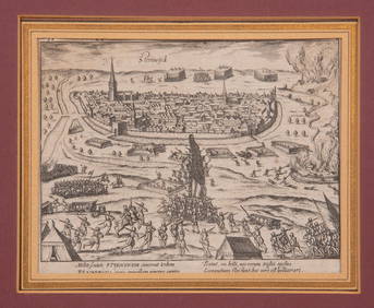
16TH C. BIRDSEYE VIEW OF SEIGE OF STEENWYCK, NETHERLANDS BY FRANS HOGENBERG (1535-1590)Thomaston Place Auction Galleries4.4(386)See Sold PriceFeb 24, 2024
MAP OF SALZBURG BY GEORGE BRAUN & FRANS HOGENBURG. 1588Thomaston Place Auction Galleries4.4(386)See Sold PriceFeb 24, 2024
Antique German Kampen Town Color Copper EtchingHill Auction Gallery 4.7(1k)See Sold PriceFeb 28, 2024
Willem Blaeu, Etc. 17th C. Antiquarian Maps, 2Auctions at Showplace4.5(726)See Sold PriceMar 17, 2024
A matched five-piece late 19th-century American tea-serviceLyon & Turnbull4.3(51)See Sold PriceMar 05, 2024
Jules Verne, L'Etoile du Sud, Au Steamer Red MacaronLion and Unicorn4.7(1.8k)See Sold PriceMar 10, 2024
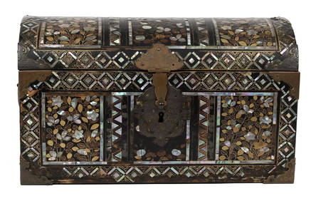
16TH C. JAPANESE MOMOYAMA INLAID LACQUERED CASKET.William Smith Auctions4.6(146)See Sold PriceMar 06, 2024